+Muzikman Posted November 15, 2004 Share Posted November 15, 2004 (edited) After looking through one of the threads and seeing the pictures of this find by Shirley and John it got me wondering. There is a mark near a local cache and as it usually happens many people have logged it. But I am really starting to wonder if they are logging the wrong mark, and here is why. Please tell me if I sound way off here. Mark is "INDIAN" In the datasheet it states that the disk is in the top of a 33x6x6 post and that it is set 30" into the ground. There is then stones piled around it. The mark that is found is in a roughly 6x6 post, but it is a lot more than 3" above ground. Although when I was there I did not measure the height, but it's atleast 12" above. I assume errostion could have been a factor, but seeing as the ground is very rocky and most of the rocks are large, I don't see them moving or settling very much in 100 years. Then, about 20 feet away from the mark is an odd round pile of rocks about 4 foot high and 5 foot in diameter. This makes me wonder, what are the chances of the real mark being under this nice pile of stone and that the USGS just placed another mark close by that is not in the database? Here are some pictures. Edited November 15, 2004 by Muzikman Quote Link to comment
Markonthedot Posted November 15, 2004 Share Posted November 15, 2004 To be Honest with you, it may be possible. now, i can't see the link to the benchmark's page, is it a triangulation disk? because that could be a RM to that Marker. but as i said, i cannot see the page (comp problems). Quote Link to comment
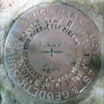
+GEO*Trailblazer 1 Posted November 15, 2004 Share Posted November 15, 2004 CURRENT DATA SHEET NGS INDIAN KX2056 Quote Link to comment
+Muzikman Posted November 15, 2004 Author Share Posted November 15, 2004 Yeah, I saw that. But I assume the update was from a geocacher. Quote Link to comment
Bill93 Posted November 15, 2004 Share Posted November 15, 2004 The evidence available to me says this is the mark you refer to. Note that someone submitted a FOUND to NGS in 2003 after the GC data base was captured from NGS. The mark was set by the agency (USGS) listed on the data sheet. The pictured disk was not stamped with an identifier and the data sheet does not mention stamping so there is no conflict there. Several people have reported that the coordinates are "dead on" or within handheld accuracy, which they should be for a mark like this one with ADJUSTED position. That much change in the ground level seems reasonable to me, who has not been there to see for himself. There is no mention of reference marks in the description. The pile of rocks could have been moved by anyone in the last 100 years. The pile of shale in the picture is not the pyramidal shape I'd expect to be used around a mark and is too big. Quote Link to comment
+Colorado Papa Posted November 15, 2004 Share Posted November 15, 2004 I'm inclinded to agree that the correct mark is in the pile of rocks. The identification INDIAN bothers me. I wonder how it was so designated when the mark you pictured has no marking other than PENNSYLVANIA. The 33 also makes me wonder what that means. You could try probing and see if the pictured mark base is about 30 inches below the surface. On the other hand, the original description makes no reference that the mark was stamped. Hmmmm???? ...MARBLE POST 33 BY 6 BY 6-IN. SET 30 IN. IN GROUND, IN KX2056'CENTER OF TOP OF WHICH IS CEMENTED A STANDARD TRIANGULATION DISK AND KX2056'AROUND WHICH IS PLACED A PILE OF STONES. Quote Link to comment
evenfall Posted November 15, 2004 Share Posted November 15, 2004 Hey All, This is one of those rare occasions that the USGS set a Triangulation Station. Please note that this disc is the usual thing you see with mention of Bench Mark and other elevation markings. But it also says Pennsylvania on it. These State named stations are not found too often. It is in a Marble post. The Post Measures 33 inches long, 6 inches by 6 inches square. This was a common average size among settings. Frost heave could have been a factor as to why it has appears to have come up out of the ground, it also may have been erosion, but by not being there on location, it would be difficult for me to evaluate that. As mentioned, there was to have been rocks placed around this station that may have been since moved. The NGS Datasheet says the is a third order horizontal station, It should be within 1-3 inches of perfect, horizontally. There is only Scaled Bench Marked elevation for this station. It was never Leveled. Also rare for USGS stations. The argument for using the same display format as the NGS datasheet is a good one here, let's look at the the comparisons. NAD 83(1995)- 40 27 52.12331(N) 079 45 13.96293(W) ADJUSTED (NGS Datasheet) ddd.mm.sssss format I convert this to: 40 27.8687218333 079 45.2327155 in dd.mm.mmmmm Format Minutes + (Seconds / 60) This compares favorably to GPSr waypoint captures on location of: N 40° 27.869 W 079° 45.233 As taken by Red Shoe & The Navigator. The GC.com site has N 40° 27.869 W 079° 45.233 (NAD 83) Altitude: 1362 Coordinates may not be exact. Altitude is SCALED and location is ADJUSTED It is of course very easy to verify the datasheet and the GPSr set to NAD 83 and ddd.mm.sssss mode right at the location when the settings are alike and we are there. With a good GPS constellation, and hopefully WAAS, if there is nothing else within 5-15 feet you are Money, That's buttah. On the Nut! Dead Nuts even! Close enough for who it's for, I'm Talkin' Yeah baby! And right then and there the data compares in black and white, favorably with the datasheet. You immediately know for sure. I know a lot of people like to use the geocaching Data, but GC has converted it to a different format from the Original Source. Their conversion also rounds off some of the accuracy. Sorry, but it does. I know Palm Pilots are cool, but I like the datasheet, there is a lot more information on that sheet you will like knowing once you learn about reading it better, like if there are ref marks, azimuth marks and the bearings and distances to them (in meters, multiply by 0.3048 to convert to feet), other nearby stations etc... And you can write notes, draw pictures, even scribble on the back. Push come to shove you can use them to help start a camp fire. Your campfire results may vary with the palm pilot. Converting the format after the fact is not as fun and you have two different numbers to look at in different formats which are the same place but don't compare and.... Ugh. It can kinda leave us wondering sometimes. Always using the same format with the most accuracy Triangulation Station Lat & Lon which is adjusted, taken from the datasheet should be more accurate than your GPS can reveal. If they do not compare favorably when in the similar modes, you have either an error in the data or the wrong station. Something worth investigating further. There was no mention of a Cairn in this description, and how do the Coordinates for the stacked rocks compare with the datasheet? That could help rule out the rockpile... Given all we have to go on, I would say you bagged your station. Rob Quote Link to comment
mrh - terre haute Posted November 15, 2004 Share Posted November 15, 2004 (edited) Could it be that the pile of stones was placed around the monument as originally described and moved at a later date for access to the mark and then not replaced? I suppose someone could move the pile of stones to check Rob's conclusion. It is a pretty big pile of stones though Edited November 15, 2004 by mrh - terre haute Quote Link to comment
+AtoZ Posted November 16, 2004 Share Posted November 16, 2004 The problem of the post rising, no the ground did subside, is that freezing thawing causes rock, or more harder material then the dirt around them to rise upwards as the ground squeezes the harder material upwards. You see when you cleared a field of rocks one summer and the next spring it is full of rocks again, UGH. Ol well just a thought. cheers Quote Link to comment
mrh - terre haute Posted November 16, 2004 Share Posted November 16, 2004 That's what I figured the pile of stones was originally intended to prevent by providing "insulation" from freeze-thaw. Around here the frostline could go three feet below the surface. With the marble post being only 33" inches long it couldn't be set to that depth if any was to be visible above the surface. Quote Link to comment
+Airnut Posted November 17, 2004 Share Posted November 17, 2004 I also found this disk. That is the correct disk. This is an adjusted mark and the coordinates were exact. But I have no explanation on the height discrepancy. I made a note of it in my log. The pile of stones in the picture is about fifty feet away from the disk. That is my picture on the page for the nearby cache. Quote Link to comment

Recommended Posts
Join the conversation
You can post now and register later. If you have an account, sign in now to post with your account.
Note: Your post will require moderator approval before it will be visible.