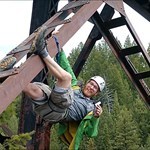
+CheekyBrit Posted October 21, 2021 Share Posted October 21, 2021 (edited) We're looking for intense, exposed, dangerous, scary or otherwise impressively high rated terrain photographs. If you'd preface showing the photo with 'you'll never believe this', it probably belongs here.Scrambling down in to the rift in the cliff to find the letterbox and spot the easter island worthy formation. GC8CDYH Face of the Mountain Entering a slot canyon for GC9H5DD 'Lurch canyon - Star Wars episode IX part 2'About to rappel into narrow fissure 2-3' wide, 30' deep. GC9H56R 'Sinking fields - Star Wars episode IX part 3' Haystack mountain GC1ZZJQ - Just don't bother approaching from the west like I did, it is daft steep and loose with guardian cliff bands.Rappelling down GC8KK1J Leap of Faith, a tidy little 30' rappel.The insane 100'+ cliffs of Howard Mountain GC8CX8M Quarder dose of vertigo Edited October 21, 2021 by CheekyBrit pressed enter too early 1 Quote Link to comment
+Viajero Perdido Posted October 21, 2021 Share Posted October 21, 2021 (edited) (Photo slightly embellished; weather not as shown.) "The mountain keeper gets stronger with every bolt". Falls Fire Lookout (original name). This second one is an accurate photo, but the lightning bolt was added afterwards to match what I saw with my (very big) eyeballs: lightning entirely below my own altitude. My blood froze, then I ran down the mountain with my feet barely touching the ground. (I've been lightning'd off a few peaks, but never seem to grab pictures; more pressing matters.) BTW, that's Canmore down below, and this is the first wave of the epic 2013 storm, which did massive damage two days later. Learning to Fly Edited October 21, 2021 by Viajero Perdido 1 Quote Link to comment
+CheekyBrit Posted October 21, 2021 Author Share Posted October 21, 2021 45 minutes ago, Viajero Perdido said: (Photo slightly embellished; weather not as shown.) lightning is so hard to catch, photo embellishing is understood. Those seemed like gnarly locations even before the lightning came rolling in. Quote Link to comment
+Viajero Perdido Posted October 21, 2021 Share Posted October 21, 2021 (edited) Here are two views of the same peak from opposite directions. (I tilted the camera for fun in the first picture; you can see the true angles in the second, reversed of course.) October in the Canadian Rockies. There's a very fun scramble ascent below the "Hard" cliffs, up that bowl. BTW, I dropped the logbook ziploc here and watched it disappear down the abyss, or at least appear to. Miraculously, something stopped its descent only a few hundred calories below, and I got it back. Flying Machines EEOR Summit EDIT to add the fun scramble I mentioned for the first picture above: right up this bowl to the saddle, where the cache was. I didn't attempt this route on that snowy October day; just took the trail. Edited October 21, 2021 by Viajero Perdido Quote Link to comment

Recommended Posts
Join the conversation
You can post now and register later. If you have an account, sign in now to post with your account.
Note: Your post will require moderator approval before it will be visible.