Natebreed810 Posted January 18, 2018 Share Posted January 18, 2018 (edited) On a Kayak trip this weekend I stumbled across a Geocache in a .30 cal ammo can that had been washed away apparently during Hurricane Irma. The cache was pretty obviously not where it was supposed to be and water logged so I loaded it into my kayak and moved it to a more suitable and accessible spot further down the river. I couldn't find any specific number on the cache but did find a log of the most recent visitors. It had been active pretty recently. I am only vaguely familiar with Geocaching but I was hoping the community could help with finding the owner and updating the location if possible. It was on the Withalacoochee River in Florida which looks like it has a ton of caches. Could I work backwards from the visitor log to find the owner or original location? Thanks all. Edited January 18, 2018 by Natebreed810 1 Quote Link to comment
+hzoi Posted January 18, 2018 Share Posted January 18, 2018 2 hours ago, Natebreed810 said: On a Kayak trip this weekend I stumbled across a Geocache in a .30 cal ammo can that had been washed away apparently during Hurricane Irma. The cache was pretty obviously not where it was supposed to be and water logged so I loaded it into my kayak and moved it to a more suitable and accessible spot further down the river. I couldn't find any specific number on the cache but did find a log of the most recent visitors. It had been active pretty recently. I am only vaguely familiar with Geocaching but I was hoping the community could help with finding the owner and updating the location if possible. It was on the Withalacoochee River in Florida which looks like it has a ton of caches. Could I work backwards from the visitor log to find the owner or original location? Thanks all. On behalf of the geocche owner, whoever it ends up being, thank YOU for coming here to try to find its owner! Often, but not always, a geocache will be marked with a GC code (between 4-7 characters, combination of letters and numbers, such as GC1D or GC7A3XM), owner name, coordinates, and the cache title. These are usually the easiest way to identify a given geocache. If you find any of those but aren't familiar enough with geocaching to use this information to search for the geocache, just post 'em here. I always like solving puzzles like this. If it has none of those things, it can still be done by looking up different user names from the log, breaking down the geocaches they found on the date in the log, and then using process of elimination to find the one geocache that matches up. Obviously this takes a little longer than directly looking it up, but it's doable. Can you post back with more information, or take clear pictures of the log and post them here? Quote Link to comment
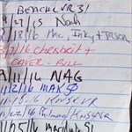
Natebreed810 Posted January 19, 2018 Author Share Posted January 19, 2018 Ive tried posting the picture of the log a couple times but I keep getting error 200 something. There wasn't any code like that although there was a stenciled area for it on the side of the can, it may have been washed off. I didn't get a picture of the most recent visit as someone had put it on a random page but best as I can tell here is the rest. 1/20/17 BS or B5 1/12/16 YRWELOST or YRWELO5T 11/25/16 Mardub51 11/22/16 KNSLVR ????? 11/2/16 MAK50 9/11/16 NAG 3/7/16 chrisbritt and Caver-bill 2/18/16 MRC, Inky + Jason 09/27/15 Noah 1/23/15 1CUZ and BEACHLVR31 1/18/15 Teachbs65 Quote Link to comment
Natebreed810 Posted January 19, 2018 Author Share Posted January 19, 2018 (edited) If someone else wants to try posting the picture I'll email it but it won't let me post from my phone or PC. Edited to add I made the list my profile pic if that helps anybody out. The cache was moved to the tip of an island on Silver Lake 28°34'19.32"N 82°12'34.64"W and I put the can in crook of a couple cypress knees. I took a T-rex Toy and left a can coozie. Edited January 19, 2018 by Natebreed810 Quote Link to comment
+kunarion Posted January 19, 2018 Share Posted January 19, 2018 (edited) There are two or three with similar logs, but I think it's this one: https://coord.info/GCNTC0 The box was lost in the storm last fall, and was replaced in November. In which case, the one the OP found had washed about three miles from its spot. Edited January 19, 2018 by kunarion Quote Link to comment
+Isonzo Karst Posted January 19, 2018 Share Posted January 19, 2018 Quote The cache was moved to the tip of an island on Silver Lake 28°34'19.32"N 82°12'34.64"W Hey, thanks for posting NateBreed810. That can is likely mine or Eagle Dad's on the same stretch of trail along the river, south of Silver Lake. Both of us lost cans downstream in the Irma flooding. I replaced mine at Low Passage, GCNTC0 and he archived his Ammo Oak @ River Trail, GCNMJ0. They would both pretty much the same set of signatures. His was a 50, mine may have been a 50, more likely a 30. Frankly, I don't recall. If you left it around those coords, I can get out in yak myself and hunt it. Or actually just walk it, I suspect that's a dry(ish) walk now from the ramp at Crooked River. Quote Link to comment
Natebreed810 Posted January 19, 2018 Author Share Posted January 19, 2018 Awesome! Yeah you should be able to walk out there from the ramp. I dried it out the best I could but a lot of stuff was damaged. Is there a way to update or add its location? Quote Link to comment
+Isonzo Karst Posted January 19, 2018 Share Posted January 19, 2018 So I'm back from my successful hunt of the ammo can. It is Eagle Dad's from Ammo Oak @ River Trail. https://coord.info/GCNMJ0 Natebreed810, you could log your find on that cache page, an unusual find indeed. The stencil on the outside, and the first finder signatures in the original logbook are right for it. I'll ask Eagle Dad what he wants to do with it. I can put it back where it started, if he wants to get that listing unarchived. Quote Is there a way to update or add its location? Well, its current location is my front porch. When a cache moves that far, the cache page (listing) would have to start over as a new cache listing. 1 Quote Link to comment
+Eagle Dad Posted January 20, 2018 Share Posted January 20, 2018 Holy Canoli. That is about the craziest Geo=story I have ever been a part of..........Gary aka Eagle Dad 2 Quote Link to comment
+jakeuc2 Posted September 29, 2018 Share Posted September 29, 2018 There was some cache, don't remember the name now, in Perdido Key, AL, last October, that when we visited just after Hurricane Nate came through, the ammo can was ripped off the zip ties. Quote Link to comment

Recommended Posts
Join the conversation
You can post now and register later. If you have an account, sign in now to post with your account.
Note: Your post will require moderator approval before it will be visible.