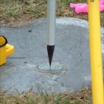
+Ernmark Posted August 6, 2014 Share Posted August 6, 2014 I have a picture of a PLSS marker located in Haw Creek Falls, Arkansas without the coordinates that go with it: Is it possible to figure out the coordinates where it should be? Closest coordinates given were probably within a few miles, I believe (N 35° 40.584 W 093° 15.324) - Being an Easterner, I'm not really up on the TWP/Ranges grid, although I've read over some of the charts Quote Link to comment
foxtrot_xray Posted August 6, 2014 Share Posted August 6, 2014 I'm sure others here know better than I, as I've never really gotten into these. But from what I remember, that came from Township 12 (T12), Range 21 (R21), and was on the line between sections 29 and 30. I'm NOT sure what the 1/4 is, though.. But you already knew this, since you found it on a map. I don't think you'll get much more of abetter location than that.. Quote Link to comment
Bill93 Posted August 7, 2014 Share Posted August 7, 2014 (edited) The 1/4 is for quarter corner, so this is a corner of a quarter-section, that (ideally) falls halfway between the section corners. If the original surveyor measured accurately you will find it within map reading accuracy of the exact midpoint of that mile. In rugged country it isn't always accurate. The line between these particular sections should be as regular as anything in the neighborhood. There are exceptions such as in the last sections to the north and west (in other places south or east) as you come up against a township line, where all the accumulated error for the township was thrown in the last half-section, and the quarter corner was measured out a half-mile from the prior section corner no matter what that left for the closing length. If you were looking for the north 1/4 corner of section 30, for instance, you would have that issue. Try reading the the latitudes of the section corners to the north and south and averaging them. (Watch out for the other kinds of lines on the map so you do get the section corners.) Ditto longitude if the line isn't perfectly N-S. Somebody has a tool that will give approximate lat-lon for any section, but it is mostly for getting in the neighborhood and is probably less accurate than the topo map. If the topo shows straight fences that fall near the quarter-section lines (none here), the map-makers probably assumed those fences were built to the surveyors' corners and you might try that assumption too. Edited August 7, 2014 by Bill93 Quote Link to comment
CallawayMT Posted August 8, 2014 Share Posted August 8, 2014 I have a picture of a PLSS marker located in Haw Creek Falls, Arkansas without the coordinates that go with it: Is it possible to figure out the coordinates where it should be? Closest coordinates given were probably within a few miles, I believe (N 35° 40.584 W 093° 15.324) - Being an Easterner, I'm not really up on the TWP/Ranges grid, although I've read over some of the charts The best available information for the most probable location of the PLSS corner monuments was derived from the GLO record information which was then adjusted to good and not so good controlling corners. This information was then least squares adjusted using Geographic Measurement Management software and generally by the BLM or a private contractor for the BLM. This information can be retrieved as shapefiles from GeoCommunicator.gov. I downloaded the shapefile and queried that corner and here are the NAD83 DMS geographic coordinates: 35°39'53.79"N 93°15'15.35"W. Another way you can do it is to go to:PLSSGE and you can search corners by TRS or other searches and zoom into Google Earth to get the value. This GE plugin is using the shapefiles created by the GCDB to generate the PLSS linework onto Google Earth. Kurt Quote Link to comment
kayakbird Posted August 8, 2014 Share Posted August 8, 2014 Ernmark, I thinks that I see a little red cross on the north side of your USGS map that should be the 'found' quarter corner on the north-south line between S19 & S20. Found meaning that the monument was there when USGS did the field work for that map. These 'found' symbols can be a good place to look on Google Earth for fence lines, etc., and start using the GE 'Ruler Tool' from there. I am becoming more and more impressed with the accuracy of Lat/Long's that can be plucked off Google Earth; and elevations can be more accurate than HH2's. kayakbird Quote Link to comment
+Ernmark Posted August 8, 2014 Author Share Posted August 8, 2014 Thanks for the info everyone! As an aside, I recently was able to stop by the Point of Beginning (well technically 1112' north of it) on the OH/PA/WV border where the first survey of what was to become the US PLSS system began in 1785 - there's a nice (no-PID) monument there which was featured in Rhonda Rushing's book 'Lasting Impressions'. I was probably more impressed than my Daughters were Quote Link to comment
Z15 Posted August 8, 2014 Share Posted August 8, 2014 (edited) Fyi http://www.forestry-suppliers.com/product_pages/Products.asp?mi=59221&title=Forestry+Suppliers%92+Topo+Aid&itemnum=45675 Quickly determines longitude and latitude of any point on USGS 7.5- and 15-Minute Topographic Maps. Accurate to the nearest second on 7.5-minute maps and 5 seconds on 15-minute maps. Edited August 8, 2014 by Z15 Quote Link to comment

Recommended Posts
Join the conversation
You can post now and register later. If you have an account, sign in now to post with your account.
Note: Your post will require moderator approval before it will be visible.