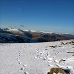
Langy Posted August 15, 2012 Share Posted August 15, 2012 I thought after my recent outing caching that I would start off a new topic so I will explain about my outing. We recently moved to Cumbria not far away from Carlisle, so the chances and choices of visiting the lake district for the wonderful views is right on our doorstep. I mostly do the walks on my own as I do like to head to the high hills and have the harder walks. Last Saturday 11 August 2012 I had decided to make a trip to Seat Sadal. Seat Sadal is one of those summits which is surrounded by some higher peaks which usually appeal to others more so is less visited. Being unsure as to how well I would get on I found a walk which went up to Seat Sadal and down the other side to make a reasonable sized walk. At the same time I wanted to be prepared that if I felt up to it whilst at the summit I could take on a different return route up to Fairfield and down via Great Rigg. After reaching the summit at Seat Sadal and finding he cache another hiker appeared (from Newcastle not that is relevant but just some more info) and we started talking about some of the other hills. I knew that Helvellyn was close by and he pointed out that a steep climb up Dollywagon Pike would mean a nice gentle climb up to Nethermost Pike and then on to Helvellyn and Helluva Long Walk. He was right, after a scramble up Dollywagon Pike the terrain became much easier. The sun was out (for a change the first weekend without rain on a walk) and I could feel my neck getting rather warm. It didn't take too long to clock up the caches and reach the summits. What was hard was the return journey. This was taken by a more direct route down near to Nethermost Pike. The first few hundred feet of descent was quite easy. It was for around 2000 feet of the descent where it was a constant downhill, mainly of cobble stones (where getting the right footing was essential) that it was most hardest on the knees. When I finally made it back down to level ground I still had 2 - 3 miles walk back to the car. So in summary I had made several plans for the trip but was easily able to modify these whilst out on route. I had enough supplies to last the 8 and a half hours I was away from the car. I knew by the end of the walk that I had just about hit my limit as to how far I could have gone. I could have made some additional changes that would have made the trip easier. It just goes to show though that had I made any more changes and not researched properly before I started out that I could so easily have gone way beyond my limits. It will be nice to hear from others where they have either got close to those limits like myself or actually gone beyond them just to make this a topic for everyone to add and read to. Quote Link to comment
+Sharks-N-Beans Posted August 15, 2012 Share Posted August 15, 2012 I clicked on this topic from the front page of the Forums page not realizing it was in the UK/IRE threads. My story, although originating in the US, seems applicable. We were caching in the West Virginia hills and targeted a series of three caches. We knew the terrain would push our abilities but did not plan on making some very bad decisions that would add to our plight. The overall experience had us hiking 8 hours. It may not be apparent from our final log below, but the ill advised descent to grab "one more cache" was about 1500 feet. The slope was about 45 degrees. Our log from the final in the series: We made the trek from The Bad without any trouble, arriving about 3:15.. In hind-sight, we think we may have made the 1st and 2nd stages harder than necessary because each were more difficult from a terrain standpoint. Once again, GZ was a great spot. This was Shark's favorite of the three. We found the cache pretty quick, signed the log and rested for a few. The journey, however, was just beginning and was about to turn very ugly. We decided to grab a few caches on the way back and set our sights on Snake Hill WMA...Take a Hike. We went right at it only to run into the little waterfall. Looking down the hill, we saw a spot that we could cross so we headed down (BIG MISTAKE), and crossed. Once across, we went around the bend looking for a trail to get us up to WMA. The one to the SE was really steep so we took one that wrapped around the waterfall side. Unfortunately, when we got about a quarter of the way up, the trail disappeared. So there we were with no where to go but up the side and across the face of the hill in search of a trail. We went across and were below WMA when we realized there were not any trails. Looking up the hill, we saw some markers so we drug ourselves up the hill. It wasn't long before we realized these were not trail markers, but rather markers for selective tree cutting. What else could we do but continue up? After about another half hour, we were still well below WMA and exhausted. We decided to end our quest for the CACHE and go SE towards the car. It must have been about 5:30 when we got to the top and reached the gas well area (completely spent). There was no way we were going to take on the nearby multi as our legs were already wobbly and we still had three quarter mile to the car in unknown terrain. Looking at the map now, it looks like going for the multi would have provided a service road. We did consider to go for the nearby MAGPI, but quickty ruled that out due to vegitation. Once again, going for it would have brought us close to a service road. Instead, we found a clearer path down into the gourge and swinging around MAGPI. We drug ourselves SE from there and made it to a service road which we took. We actually came within 100' of Buzzards Head but were too exhausted to attempt. The road took us to the parking area that we should have used, but our car was another 1100' SE. We made that leg on Snake Hill Road. We made alot of mistakes that cost us alot of energy and extra caches, but we got the series and that was our goal. Strangely enough, even with this disasterous return trek, The UGLY is also one of our favorite all time. Thanks for placing all three great caches. Quote Link to comment
+Simply Paul Posted August 16, 2012 Share Posted August 16, 2012 One word: Geolympix Quote Link to comment
+agentmancuso Posted August 20, 2012 Share Posted August 20, 2012 I tried walking across France when I was a teenager. Nearly made it too. Long before geocaching was invented. Quote Link to comment
+drsolly Posted August 20, 2012 Share Posted August 20, 2012 The Essex Death March, done round about last Christmas. It's 14 miles, and my maximum is 12. Plus I had tendonitis in my hip at the time. Plus it was wet and muddy, and the slipping around increases the effort. Plus, my boots were too tight, so they were hurting my toes. By the time we got to the far end, I could barely lift my legs, and it took me three days to recover. And then there's the time I jumped into a hole, and couldn't get out. And there's the time, about 20 months ago, when I went caching near Gravesend, thinking that the snow had thawed, but not at Gravesend it hadn't, so I did 52 caches with 20 inches of snow on the ground, and I was the first fool along the footpaths since the snow, so I was breaking trail the whole way, and what should have taken 4-5 hours took 10, and I had no food or water with me (in winter, I find I don't need water during the day) but I did have a head torch so that when it got dark at 4pm I could carry on, and round about five I was walking in a wood along the side of a hill; steep uphill on my left, steep downhill on my right, all concealed under the snow, and a big tree had fallen across the track, and I had to make a major effort to get around it, and then I found somewhere to sit for a moment, and made the wonderful discovery that I had a banana in my pocket, best banana I've ever eaten, and when I got back to the car at about 7:30 I could barely move and my feet were frozen (my hands pretty cold too), and as I drove home, I kept getting cramp in my legs from the exhaustion. A great day out, I found all 52 caches. So yes, I've pushed myself too far quite often. That's part of the fun. Quote Link to comment
+Simply Paul Posted August 20, 2012 Share Posted August 20, 2012 Lady Solly has the doc well insured, for some reason... Quote Link to comment
+The_Street_Searchers Posted August 22, 2012 Share Posted August 22, 2012 A couple of weekends ago my good muggle friend Edward and I left the relative comfort of Sussex and our women folk to take in the Mountains of the Brecon Beacons. Think Broke Back Mountain without the horses and the homosexuality. We had planned to take in Pen-Y-Fan and then see where our feet took us but with the general view of heading to Cribyn next. We started by tackling the biggest mountain in southern Wales, Pen-Y-Fan (886M).We walked up via Allt Ddu (550M) which was very pleasant as Wales spread out beneath us. The final part of Pen-Y-Fan required a bit of a scramble but nothing too taxing. The weather was glorious and we walked up in T-Shirts. From the top of PEN-Y-Fan we could see the summit of Corn Du (873M) very close by and despite it being in the wrong direction we decided to go and bag it. From there it was back up to Pen-Y-Fan and then a fairly robust decent via Craig Cwm Sere to 665M. It was during this decent it started to rain and as we climbed the next peak Cribyn (795M) it started to hail. Fortunately we were well prepared with waterproofs, good boots, and plenty of food and drink. We passed a lot of people not as well prepared and not having a good time. Cribyn is an amazing mountain and from the front looks exactly how a mountain should – all pointy and stuff. At the top of Cribyn we took stock, we were both still dry and feeling good. Lets do one more we thought. It does have a great name after all. And so it was that we descended Cribyn via Craig Cwm Cynwyn to 599M for taking on a very steep climb to the top of Fan-y-Big and the famous diving board. It was still raining heavily and by this time my ‘Sussex’ proof jacket decided it wasn’t up to the Brecons. Edds boots also did the same. So here we are having mounted a Big Fan y soaking wet (that kept us going for hours, so many Fan Y jokes so little time) We descended Fan-Y-Big the way we had come up and looked at the map. The car was a long way away and the path we intended to use looked more like a river. Well we couldn’t get much wetter and so off we trudged towards Bailea. It took us 2 hours from the top of Fan-Y-Big to get back to the car. It stopped raining when we got off the hills which encouraged the mozzies out to play! Anyway we had walked for around 7 hours and covered 4 peaks with significant ascents and descents. We were struggling by the end of the day and I re-learnt the lesson that I really should take into account those squiggly lines when planning my walk on the hoof. A great walk but both Edd and I suffered the next day & in reality we should have called it a day at Cribyn and come back for Fan-Y-Big the next day. I did get 2 caches though! Quote Link to comment
+Amberel Posted August 22, 2012 Share Posted August 22, 2012 Pen-Y-Fan was also my step too far. We did it in the middle of winter. But the weather deteriorated in between arranging it and arriving, and we ended up doing 15 miles in a freezing snow blizzard, with the wind so strong that it several times lifted me right off my feet and dumped me on my back. Had I been by myself I would have turned back after a third of the way, but I decided it was safer to stay with the group, even if it meant going further. I have NEVER been so glad to get back to the car, and I was even more relieved to be able to get the car back to the main road through the snow. We did find several caches, but I logged only those I helped search for - I was in survival mode for much of the way and didn't want to expend any unnecessary energy. Rgds, Andy Quote Link to comment
Dokhoyan Posted August 23, 2012 Share Posted August 23, 2012 (edited) I saw this thread and instantly thought about my recent holiday to France. On the last full day I went for a walk around the French Alps just off the Switzerland border. The signs for walkers in France don't tell you how far the next location is, but roughly how long it should take (This is due to the rapid changes in elevation causing distances to take differing amounts of time). I had planned the route in so far as to complete 4 caches (There wasn't many in the area anyway). I had my Camelbak, some sandwiches, sun cream, insect repellent and a map. The rest was to be worked out en route. I started at 1,075m, climbing to the Col de Tavaneuse (1,997m) to begin with. This took about 1 hour 15 mins of 35 - 50% upward slog. I knew pre season football workouts were necessary for me, but this was a hard slog and I way blowing by the summit. From then on, the walk consisted steep up's and down's weaving between the mountains and getting to the cache sites. My biggest problem was a lack of water, which had gone after about 2 hours in the warm weather. I resorted to filling up in streams high in the mountains - thankfully, no ill effects were felt. 7 hours later, my legs had gone through the feeling heavy stage and were taking steps by themselves. I reached Pre la Joux, a valley village from which ski lifts went into the various mountains. From here, I decided to take one lift over the final peak and into the next valley village of Les Lindarets where I had phoned my parents to pick me up. By adding up the times given on the signs, I worked out my walk should have taken around 9 hours so even though I didn't get many caches, that was certainly an acheivement. To walk over the final mountain would have probably added another 1.5 hours and I knew I couldn't do it. Could I have planned better, definately; did I enjoy it and wish it went no other way, definately! Anyone up for the three peaks! Edited August 23, 2012 by Dokhoyan Quote Link to comment

Recommended Posts
Join the conversation
You can post now and register later. If you have an account, sign in now to post with your account.
Note: Your post will require moderator approval before it will be visible.