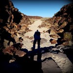
+Udink Posted June 9, 2003 Share Posted June 9, 2003 While looking for a particular benchmark this weekend, which I don't believe that I actually found, I did run across some interesting stuff. In an embedded rock on the ridge where the benchmark was supposed to be, I found a small drill hole, about 1/4" in diameter and 3/4" deep, with orange spray paint marking it. There was also a toppled target pole with a 1/4" bolt sticking out of the bottom. There were 3 large bolts driven into the ground with wire attached, presumably used to hold the pole up at one time. The datasheet says that the benchmark is a cross chiseled on a boulder, but later mentions that the cross has "been replaced," but doesn't mention what it was replaced with. A reference mark is also mentioned, but no bearing or distance is given in relation to the benchmark, and I couldn't find it either. What I did find odd was that, on the ground near the drill hole (between 10 and 25 feet away), there were three pieces of 1" x 1/4" wood, each about 14" long, staked to the ground with long nails and washers. One of these pieces of wood was wrapped in what looked like white vinyl sheeting, and covered with a couple of rocks. The others may have once been covered by vinyl at one time, but it could have rotted away since they weren't covered. Does anybody know what these pieces of wood may have been used for, or for what purpose they were placed? Here are some pictures the area, including the drill hole, target pole, and the wood staked to the ground. Quote Link to comment
+Kewaneh & Shark Posted June 9, 2003 Share Posted June 9, 2003 The pieces of wood (called lath) that you found nailed to the ground held down a lightweight plastic that was used for an aerial control panel. (There may be remnants of a fourth one if you look close.) Photogrammetrists use large crosses on the ground to see where the survey control is in their photos. Surveyors commonly mark the control with cloth or plastic sheeting held down by lath nailed to the ground. I've set many this way. The other items you found I would guess to be the remnants of a temporary triangulation station. Surveyors who needed to sight the station may have assembled the pole and the guy wires so they could see the station from a distance, and then just left it there. Did you find the reference mark, which is a brass disk, or the 'USGS' chisled into the rock? Those would be the item I would be looking for if I was to search for this one. If you found them, you could call it a find. They are part of the mark. Quote Link to comment
+Udink Posted June 9, 2003 Author Share Posted June 9, 2003 No, I didn't find the chiseled letters or the reference mark, though I'm certain I was in the right general area. I hadn't considered that the lath had at one time held down a cross for an aerial photo--if that was the case, lines running perpendicular to each of the pieces of lath should intersect near the control point (whether the temporary one that I found, or the original 1910 point that I was hoping to find). I wish I'd considered that when I was up there, because it was an arduous 3-hour mountain bike ride, and it's not likely that I'll do it again anytime soon. Quote Link to comment
dsurveyor Posted June 9, 2003 Share Posted June 9, 2003 The explanations make sense. A couple more things to consider. The location of the control point are (mostly) decided by the photo process, not the survey process. I'd bet the triangulation post was in the center of the wood pieces. I would also bet the target was NOT on the station mark but that the station mark is easily visible. Considering the paint on the target location, I would expect to find it at the station mark, also. (if they even knew it was there, or found it). dsurveyor Experience - A list of non fatal mistakes. Quote Link to comment
+Kewaneh & Shark Posted June 9, 2003 Share Posted June 9, 2003 Here's a pic of one of the cloth targets I use. You can see how the cloth is wrapped around the lath, which is then nailed to the ground. The plastic sheeting is wrapped in a similar manner and is commonly used in areas that may not get visited after the panels are set. The sheeting and lath just deteriorate. I like to use cloth panels that I can re-use. (The difference in black & white cloth is for contrast purposes for the photogrammetrist.) One advantage with using the cloth or plastic is that by rolling the them up on the lath, the legs of the panel can be custom fit to the photogrammetrists needs. In this picture, the panel is fairly small as it was a low altitude fly-over. On higher flights, we'll unroll the panel wings to 6 or 8 feet long. Areial panel are usually built like this over areas of vegitation. On asphalt or concrete, the crosses are painted. Also, dsurveyor is right that the aerial control location is determined by the photogrammetrist and not the surveyor. There's a good chance that it's pure coincidence that they are near each other. The benchmark station was placed there because it had a clear line of sight to another benchmark station. The aerial panel was placed there because it had a clear line of sight to the airplane. Keep on Caching! - Kewaneh Quote Link to comment
survey tech Posted June 9, 2003 Share Posted June 9, 2003 You will find a great many sites like this, with remains of old surveys, in the west, where the wide open spaces are ideal for both long distance visibility on the ground and aerial mapping as well. Those in the east will rarely if ever find such a site. The fact that it took three hours off road to get there is the reason that the target pole is still there. They went to the trouble of settting it up that way so they would not have to visit the spot again to retrieve any equipment. Quote Link to comment

Recommended Posts
Join the conversation
You can post now and register later. If you have an account, sign in now to post with your account.
Note: Your post will require moderator approval before it will be visible.