seldom_sn Posted September 5, 2009 Share Posted September 5, 2009 While reading the Oregon vs. Hcx accuracy thread, I noticed that Searching_ut said newer units (like the Oregon?) perform differently in canyons. I'm interested in this because my 60CSX loses signal whenever the going gets tight. I'd love to get decent traces of Angels Landing and Observation Point in Zion, but the satellites don't cooperate, and the tracklogs I find afterward look like I was wearing a jet pack. If the Oregon or other newer units perform better in canyons, I'd love to hear about it. My test would be that the 60CSX stops working in Refrigerator and Echo Canyons. Quote Link to comment
+TotemLake Posted September 6, 2009 Share Posted September 6, 2009 The truth is all GPS units will have trouble down in canyons. You're signal quailty is going to be based on reflected signal from surrounding reflective surfaces and the narrowed horizon will play into how many satellites are visible to your GPS. Timing in the day will most certainly play a critical part in good navigation through these conditions as this will be the difference to having another visible satellite or one less. Quote Link to comment
seldom_sn Posted September 6, 2009 Author Share Posted September 6, 2009 The truth is all GPS units will have trouble down in canyons. You're signal quailty is going to be based on reflected signal from surrounding reflective surfaces and the narrowed horizon will play into how many satellites are visible to your GPS. Timing in the day will most certainly play a critical part in good navigation through these conditions as this will be the difference to having another visible satellite or one less. Pretty much what I figured. I wonder what Searching_ut meant about the newer units being "different in canyons". Quote Link to comment
+user13371 Posted September 6, 2009 Share Posted September 6, 2009 How to get a sharp signal in a canyon: Keep moving (because readings taken while moving tend to reduce multipath errors), and use one of these. Quote Link to comment
eaparks Posted September 6, 2009 Share Posted September 6, 2009 While reading the Oregon vs. Hcx accuracy thread, I noticed that Searching_ut said newer units (like the Oregon?) perform differently in canyons. I'm interested in this because my 60CSX loses signal whenever the going gets tight. I'd love to get decent traces of Angels Landing and Observation Point in Zion, but the satellites don't cooperate, and the tracklogs I find afterward look like I was wearing a jet pack. If the Oregon or other newer units perform better in canyons, I'd love to hear about it. My test would be that the 60CSX stops working in Refrigerator and Echo Canyons. The 60CSx's ability to acquire and hold a satellite lock is probably the best of any recreational hand held unit. Some others may be equally as good, just not better. I have never seen any reports by anyone with any handheld in the recreational price range that outperforms the 60CSx''s ability to acquire and hold a satellite lock in tough conditions. You may go another time when the satellite constellations are more favorable and get a satellite lock. Quote Link to comment
+splashy Posted September 6, 2009 Share Posted September 6, 2009 Tracks made near to hightrise or in canyons might look funny on a computermap, but most of the time you can follow the track being on the same spot again. Any rock covering the sight of the gps will make a track 100-400 feet opposite the rock, if it gets really narrow you might have an unstable 2d lock, making a very funny track, but still more or less usable for a next time ( if you move in the same direction) If you come to crucial points like water/canyon crossing I hold the gps high and make a waypoint, waypoints, together with the track bring you where you want. Quote Link to comment
NordicMan Posted September 6, 2009 Share Posted September 6, 2009 Does the 60CSx support external antenna usage? Might wanna try that(?) Partly because the internal antenna is a quad helix & most externals are patch style. That might give a different/better result in the canyons. Quote Link to comment
MtnHermit Posted September 6, 2009 Share Posted September 6, 2009 I wonder what Searching_ut meant about the newer units being "different in canyons".I took from his comments that newer units are more sensitive and hence more subject to multipath. That's certainly been my experience in canyons. Quote Link to comment
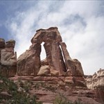
+Searching_ut Posted September 6, 2009 Share Posted September 6, 2009 (edited) What I was refering to is multipath problems. By design, GPS receeivers count on a straight line path for the signal to travel in from the satellite to the receiver. That's the assumption that is made by the receiver when it calculates how long it took for the signal to get from satellite to receiver. In a canyon, terrain often blocks out enough of the sky that your receiver doesn't have a straight line shot to 3 or more satellites depending on where they are in the sky at that given time. The system was designed so GPS receivers wouldn't pick up on reflected signals, but it happens in conditions like this sometimes, and from what I've seen it happens much more with the "High Sensitivity" receivers. Bottom line, GPS receivers only work right when you have and unobstructed (By anthing that blocks/absorbs the signal) line of sight to the satellite. If you do receive a solution fix in conditions where you don't have this ability, all bets are off as to how bad the results might be. Here is something I put up on the web back when my Sportrak was new. It's an example of issues I had climbing Angels Landing. Angels Landing For those who haven't been there, here is a photo of the lower portion of the trail: edited to add: I didn't really answer here what I meant by "different" the non "High sensitivity" units generally just quite working in the canyons, or on occasion bounced all over to the point the output wasn't usable, while the units with better sensitivity often work, but don't really know where they are, and the results unreliable. The issue, or problem when they do work with multipath is that they often remain fairly stable, and appear to be working but you can be half a mile off or more from your real position. Edited September 6, 2009 by Searching_ut Quote Link to comment
+Rockin Roddy Posted September 6, 2009 Share Posted September 6, 2009 What I was refering to is multipath problems. By design, GPS receeivers count on a straight line path for the signal to travel in from the satellite to the receiver. That's the assumption that is made by the receiver when it calculates how long it took for the signal to get from satellite to receiver. In a canyon, terrain often blocks out enough of the sky that your receiver doesn't have a straight line shot to 3 or more satellites depending on where they are in the sky at that given time. The system was designed so GPS receivers wouldn't pick up on reflected signals, but it happens in conditions like this sometimes, and from what I've seen it happens much more with the "High Sensitivity" receivers. Bottom line, GPS receivers only work right when you have and unobstructed (By anthing that blocks/absorbs the signal) line of sight to the satellite. If you do receive a solution fix in conditions where you don't have this ability, all bets are off as to how bad the results might be. Here is something I put up on the web back when my Sportrak was new. It's an example of issues I had climbing Angels Landing. Angels Landing For those who haven't been there, here is a photo of the lower portion of the trail: edited to add: I didn't really answer here what I meant by "different" the non "High sensitivity" units generally just quite working in the canyons, or on occasion bounced all over to the point the output wasn't usable, while the units with better sensitivity often work, but don't really know where they are, and the results unreliable. The issue, or problem when they do work with multipath is that they often remain fairly stable, and appear to be working but you can be half a mile off or more from your real position. I want to go there!!!! Will have to put that on my watchlist, I am hoping to take KAboom out to Vegas for some climbing later in the winter (should my money situation be right at the time). Might just have to make a trip out that way as well!! Quote Link to comment
seldom_sn Posted September 6, 2009 Author Share Posted September 6, 2009 (edited) The following is a quote from Searching_ut's response to seldom_sn's question. I'm afraid I haven't mastered the message posting software yet. Angels Landing For those who haven't been there, here is a photo of the lower portion of the trail: edited to add: I didn't really answer here what I meant by "different" the non "High sensitivity" units generally just quite working in the canyons, or on occasion bounced all over to the point the output wasn't usable, while the units with better sensitivity often work, but don't really know where they are, and the results unreliable. The issue, or problem when they do work with multipath is that they often remain fairly stable, and appear to be working but you can be half a mile off or more from your real position. Nice photo. Thanks for the clarification about "different", and thanks to everybody for the advice. My 60CSX was losing and regaining signals on that segment and the tracklog put me on top of Cathedral Mountain. Anyone who hasn't been there but is taken with the view should be aware that this shot is one of the LESS exposed portions of the hike. When you get to the "Steps of Faith" the trail is maybe 6' wide and with a drop of at least 600 feet on each side. Of course they give you a chain to hold on to and I've seen locals skipping over this portion with no hands. Edited September 6, 2009 by seldom_sn Quote Link to comment
MtnHermit Posted September 6, 2009 Share Posted September 6, 2009 That trail appears to be covered with concrete, is it? Nic pic in any case, tell's a wonderful story. Quote Link to comment
seldom_sn Posted September 6, 2009 Author Share Posted September 6, 2009 That trail appears to be covered with concrete, is it? Nic pic in any case, tell's a wonderful story. Yep, concrete. Most of the popular trails in Zion are paved. This raises a question I forgot to ask at the Visitors' Center. How did they get the water, aggregate, and cement up there? On this stretch of this trail, they could have used horses, but the upper reaches of Observation Point don't look horse friendly. Still the trail's paved, and somebody autographed the wet concrete with her feet. Quote Link to comment
Grasscatcher Posted September 6, 2009 Share Posted September 6, 2009 (edited) The truth is all GPS units will have trouble down in canyons. You're signal quailty is going to be based on reflected signal from surrounding reflective surfaces and the narrowed horizon will play into how many satellites are visible to your GPS. Timing in the day will most certainly play a critical part in good navigation through these conditions as this will be the difference to having another visible satellite or one less. Pretty much what I figured. I wonder what Searching_ut meant about the newer units being "different in canyons". If you ever plan on going back there, here's some suggestions that might improve your track results. As suggested above, use a planning program (Trimble Planning) to try and choose a time when satellite configuration will be the most favorable. Since you already are using one of the most accurate track logging GPSs (60CSx or 76CSx), for the "Track Logging method" be sure and choose "Auto", and for the "interval" choose "More Often" or "Most Often". Also use a "high mounted" external antenna, preferably velcro'd on top of your cap. Anything lower gets partially blocked by your head and neck at some angles. The choke ring antennas get real expensive , but a Garmin 25 or 27 will work, as will a Gilsson.,,,maybe not as well as a choke ring antenna, but acceptable. Also as mentioned above, KEEP MOVING. The high sensitivity chips are more susceptible to logging random points when stopped......and the external antenna will help to reduce multipath errors while still allowing the benefits of improved reception by the high sensitivity chipset. This is not a guarantee , because there are places that NOTHING will work, but it would not surprise me for you to be able to get a very acceptable tracklog on that trail using the same 60CSx GPS configured as described above.(I've been there before GPS) Edited September 6, 2009 by Grasscatcher Quote Link to comment
seldom_sn Posted September 6, 2009 Author Share Posted September 6, 2009 The truth is all GPS units will have trouble down in canyons. You're signal quailty is going to be based on reflected signal from surrounding reflective surfaces and the narrowed horizon will play into how many satellites are visible to your GPS. Timing in the day will most certainly play a critical part in good navigation through these conditions as this will be the difference to having another visible satellite or one less. Pretty much what I figured. I wonder what Searching_ut meant about the newer units being "different in canyons". If you ever plan on going back there, here's some suggestions that might improve your track results. As suggested above, use a planning program (Trimble Planning) to try and choose a time when satellite configuration will be the most favorable. Since you already are using one of the most accurate track logging GPSs (60CSx or 76CSx), for the "Track Logging method" be sure and choose "Auto", and for the "interval" choose "More Often" or "Most Often". Also use a "high mounted" external antenna, preferably velcro'd on top of your cap. Anything lower gets partially blocked by your head and neck at some angles. The choke ring antennas get real expensive , but a Garmin 25 or 27 will work, as will a Gilsson.,,,maybe not as well as a choke ring antenna, but acceptable. Also as mentioned above, KEEP MOVING. The high sensitivity chips are more susceptible to logging random points when stopped......and the external antenna will help to reduce multipath errors while still allowing the benefits of improved reception by the high sensitivity chipset. This is not a guarantee , because there are places that NOTHING will work, but it would not surprise me for you to be able to get a very acceptable tracklog on that trail using the same 60CSx GPS configured as described above.(I've been there before GPS) Thanks, I've actually got a copy of Trimble Planning. I just haven't figured out how to use it yet. Quote Link to comment
Grasscatcher Posted September 7, 2009 Share Posted September 7, 2009 Yep, it takes some playing with it (TP) to understand it. Start with the coordinates for your home and play with it. For trip planning, use the coordinates for the trip area (in this case Zion NP). To better simulate the difficult conditions at the park, be sure and set the "mask elevation" values to something like 30-35 deg to approximate higher than normal horizons. Be sure and get and use the latest Almanac info available. When you get familiar with it, you can go outside at any particular time and anywhere (that you choose "station" information for) and the satellites that "your" GPS sees will be exactly the satellites predicted. You can watch (as predicted) as it drops one satellite and picks up another at the predicted times. It is very accurate and useful, but as mentioned, takes some playing . Experiment with all the ways you can display the info. Some may make more sense to you than others. Quote Link to comment
+Searching_ut Posted September 7, 2009 Share Posted September 7, 2009 The following is a quote from Searching_ut's response to seldom_sn's question. I'm afraid I haven't mastered the message posting software yet. Angels Landing For those who haven't been there, here is a photo of the lower portion of the trail: edited to add: I didn't really answer here what I meant by "different" the non "High sensitivity" units generally just quite working in the canyons, or on occasion bounced all over to the point the output wasn't usable, while the units with better sensitivity often work, but don't really know where they are, and the results unreliable. The issue, or problem when they do work with multipath is that they often remain fairly stable, and appear to be working but you can be half a mile off or more from your real position. Nice photo. Thanks for the clarification about "different", and thanks to everybody for the advice. My 60CSX was losing and regaining signals on that segment and the tracklog put me on top of Cathedral Mountain. Anyone who hasn't been there but is taken with the view should be aware that this shot is one of the LESS exposed portions of the hike. When you get to the "Steps of Faith" the trail is maybe 6' wide and with a drop of at least 600 feet on each side. Of course they give you a chain to hold on to and I've seen locals skipping over this portion with no hands. That was indeed taken from low down on the trail. I've got many photos stored away somewhere from all portions of that hike, taken in many different seasons. It's one of those spots I end up going back to over and over again through the last 35 years or so. The narrow portion of the trail you're describing always instills a great deal of pucker factor in me, no matter how many times I do it. Yes, there is a chain, and yes, bending down some to grab it makes you feel even less stable. Of course there are those who venture too close from time to time, the last I remember from this year is described here: KSL news story If you search the local news database, you'll see someone manages to fall off here every few years. Quote Link to comment
seldom_sn Posted May 2, 2010 Author Share Posted May 2, 2010 Thought this thread was worth putting to bed. The left image below is from a Garmin 60CSX (Sirf) with a Gilsson FME antenna worn in my hat. The right image is from an OR300. Both tracks were made simultaneously starting around 11:00AM Mountain Time on 4-22-10. The OR loses the track at the start of the switchbacks in Searching_UT's photo above. The 60CSX has been bouncing around well before then. Quote Link to comment
+Team Geo-Rangers Posted November 7, 2010 Share Posted November 7, 2010 (edited) Have found that operating in downtown areas with tall buildings is actually more difficult w/r/t the induced offset error caused by RF multi-path, than typical canyons, and use the Garmin Map 60CSx. Only exception is complete loss of signal in the Painted Ladders slot canyon, while hiking east of Palm Springs. Terrain obscuration with the low power GPS RF signal ... it is what it is. Edited November 7, 2010 by Team Geo-Rangers Quote Link to comment

Recommended Posts
Join the conversation
You can post now and register later. If you have an account, sign in now to post with your account.
Note: Your post will require moderator approval before it will be visible.