+PFF Posted May 22, 2009 Share Posted May 22, 2009 The printed description for EZ4359 was very outdated. The old farm is now a residential subdivision, and I suspected that the station ended up in somebody's yard. I narrowed the search area to a specific house and knocked on the door. The owner was home and gave permission to enter his fenced backyard. As I turned and started off, he asked if I wanted a hint. "Look in the well house", he said with a grin. "It's a fake decoration." -Paul- Quote Link to comment
+Marcie/Eric Posted May 22, 2009 Share Posted May 22, 2009 Threads like this are why I am subscribed to this forum for all new posts. GREAT STORY AND PICS!!! I wish I had a BM in my backyard! Quote Link to comment
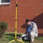
AZcachemeister Posted May 22, 2009 Share Posted May 22, 2009 Hmmm, there is something about that second photo that seems odd... Quote Link to comment
+Black Dog Trackers Posted May 22, 2009 Share Posted May 22, 2009 It does look to be a bit loose sitting in there on its throne. Quote Link to comment
Bill93 Posted May 22, 2009 Share Posted May 22, 2009 My thought too. Was the ground graded down about 3 feet around the concrete when they developed the land? Or was that chunk of concrete moved here from somewhere else in the neighborhood? Why is the bottom a cylinder of larger diameter than the main shaft? This size of concrete base was usually poured in place and the bottom is crude with a circular or square form on the top part. Pretty hard to form the shape I see. Quote Link to comment
Difficult Run Posted May 22, 2009 Share Posted May 22, 2009 I'd be curious if the mark is still in it's original position, given that it projects 20 inches instead of 2 inches as described in 1969. This leads me to suspect that it may have been bulldozed and "reset" by well meaning construction workers. ~ Mitch ~ Aww... Bill beat me to the punch. Quote Link to comment
+Black Dog Trackers Posted May 22, 2009 Share Posted May 22, 2009 (edited) The AZ's arrow points South. It should point West. Edited May 22, 2009 by Black Dog Trackers Quote Link to comment
Difficult Run Posted May 22, 2009 Share Posted May 22, 2009 I see the azimuth arrow pointing EAST, assuming that the sun is shining from the south and the second photo was taken around noon. BDT, how did you deduce it was pointing south? - just curious. ~ Mitch ~ Quote Link to comment
TillaMurphs Posted May 22, 2009 Share Posted May 22, 2009 ...but still, like Marcie/Eric said, the guy does have a benchmark is his back yard. Paul - Congratulations on your persistence in tracking down marks. Great story! Thanks for sharing. Quote Link to comment
TillaMurphs Posted May 22, 2009 Share Posted May 22, 2009 I see the azimuth arrow pointing EAST, assuming that the sun is shining from the south and the second photo was taken around noon. BDT, how did you deduce it was pointing south? - just curious. ~ Mitch ~ I am guessing maybe he figured it out from the aerial view showing the location of the well relative to the house? Quote Link to comment
+Black Dog Trackers Posted May 22, 2009 Share Posted May 22, 2009 Difficult Run - In PFF's log, the second picture shows the arrow pointing from one roof post to the other. Also it points away from the post with a knot in it and a wet spot on the ledge to the left. The third picture shows the knot and the wet spot and therefore the arrow points in a direction parallel to the side of the house with the deck and away from the parked cars. The fourth picture (aerial) shows that this direction is (down) South. (I checked with the Google Maps link on the AZ mark's benchmarking page.) As TillaMurphs says, it is a very cool adventure shared by PFF ! Quote Link to comment
Difficult Run Posted May 22, 2009 Share Posted May 22, 2009 I am guessing maybe he figured it out from the aerial view showing the location of the well relative to the house? Ok. - I'll buy that. BDT, I follow your logic and agree. Nice catch! ... and Paul, thanks for sharing this. - Makes for an interesting mystery! ~ Mitch ~ Quote Link to comment
Bill93 Posted May 22, 2009 Share Posted May 22, 2009 Great thinking, BDT. I was fooled by the high sun angle and figured the sun would be south, but the aerial clinches your argument. The pointing discrepancy is not conclusive because it wouldn't be the first time a disk was set pointing other than the intended direction, but it certainly adds suspicion to an already suspicious set of circumstances. Quote Link to comment
+shorbird Posted May 22, 2009 Share Posted May 22, 2009 A picture is worth a thousand words. Thanks, Paul. Quote Link to comment
Difficult Run Posted May 22, 2009 Share Posted May 22, 2009 Paul, Two questions for ya: 1) Did you ever think your post would get this kind of reaction? 2) Is it possible that the lower chunk of concrete contains an underground mark? (Probably not since it's a azimuth, but who knows?) ~ Mitch ~ Quote Link to comment
+PFF Posted May 23, 2009 Author Share Posted May 23, 2009 (edited) Paul, Two questions for ya: 1) Did you ever think your post would get this kind of reaction? 2) Is it possible that the lower chunk of concrete contains an underground mark? (Probably not since it's a azimuth, but who knows?) Hi, Mitch, The reaction was fun to watch. But what got my attention was the accuracy of the photo analysis. You, Black Dog Trackers, and Bill93 nailed it precisely, from hundreds of miles away. *The photos were taken at 4:30 PM. *The arrow does, indeed, point south. *The physical location agrees with the GPS reading--at least to the degree of accuracy available with a consumer-grade unit. As Bill said, "The pointing discrepancy is not conclusive because it wouldn't be the first time a disk was set pointing other than the intended direction, but it certainly adds suspicion to an already suspicious set of circumstances." Adding to these questionable circumstances, a comparison of the pre-construction topo map with the contours on the Franklin County GIS website shows that no major grading took place. The land has nearly the same shape in both renderings. But, construction usually involves using big equipment to move dirt, even if you don't have to grade away a hill. The mark may have been uprooted in the process. The data sheet indicates that mark was monumented in 1976 by CGS. However, the main station's data sheet shows a monumentation date of 1969, or seven years earlier, and the stamping on the disk supports 1969. We know that NCGS set a lot of marks in the immediate vicinity in 1976. Here's my theory about what happened: One of the nearby 1976 NCGS marks is EZ4360 (POLLY), and its data sheet gives the bearing and distance to this Azimuth Mark. Hence, we know it existed in good condition at that time. Because it is uncommon for an Azimuth Mark to have adjusted coordinates and its own PID, it may be that the 1976 party did what was necessary for upgrading to this Order. After 1976, we have a 13-year gap in the history. The subdivision was laid out in 1989 by a surveyor from Youngsville, North Carolina. He has been active in the general vicinity of this mark, and probably would have known of its existence. However, he used EZ4360 (POLLY) as a tie--even though the Azimuth Mark, with its now-adjusted coordinates, would have been centrally located within the project's early phases. I believe we can conclude that the mark was deemed unusable in 1989, possibly because it was in the way of construction and already had been "destroyed", or the surveyor knew that it would be. (There are numerous examples in the NGS database of such predictions.) What we see today is a carefully preserved artifact--most likely not understood by those who set it back into an upright position and then built a roof over it. (Occupy THIS!) Again, great job, folks! You'll probably be getting job offers from the people who sit in windowless rooms and pour over satellite photos. I certainly can endorse you for a position with "The Company". -Paul- Edited May 23, 2009 by PFF Quote Link to comment
Wintertime Posted May 23, 2009 Share Posted May 23, 2009 Again, great job, folks! You'll probably be getting job offers from the people who sit in windowless rooms and pour over satellite photos. I certainly can endorse you for a position with "The Company". LOL! You know, the Company has actually been running recruiting ads on San Francisco radio stations. At least, I've heard them on one or two news/talk stations. Really surprised me the first time I heard one! But unlike some agencies, it isn't a secret that they exist, so I guess they look for effective ways to recruit just like any other organization. Haven't heard any spots for NGS or BLM or USGS, though. Maybe they don't have as much funding as the CIA does. Oh, here we go--the Company has some openings for geographers: https://www.cia.gov/careers/jobs/view-all-j...geographer.html Patty Quote Link to comment
foxtrot_xray Posted May 23, 2009 Share Posted May 23, 2009 (Occupy THIS!) I was going to ask if you had asked the homeowner if anyone had come out to use it. Quote Link to comment
+pgrig Posted May 23, 2009 Share Posted May 23, 2009 Hi Patty-- I would think the CIA would be battering down our doors seeking our expertise in "related fields." I'd like to say more about the interest your posting kindled in me, BUT: The Company says: " Friends, family, individuals [benchmark-hunters], or organizations may be interested to learn that you are an applicant for or an employee of the CIA. Their interest, however, may not be benign or in your best interest. You cannot control whom they would tell. We therefore ask you to exercise discretion and good judgment in disclosing your interest in a position with the Agency. You will receive further guidance on this topic as you proceed through your CIA employment processing." In other words, I could tell you, but then they might have to shoot me. Quote Link to comment

Recommended Posts
Join the conversation
You can post now and register later. If you have an account, sign in now to post with your account.
Note: Your post will require moderator approval before it will be visible.