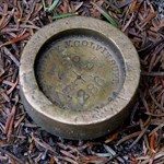
+NB2E-HAM Posted March 3, 2009 Share Posted March 3, 2009 I'd like to visit and document as many of the remaining marks as possible that were set by Verplanck Colvin and his teams during the initial Adirondack Survey here in New York. I've been reading his annual reports to the state legislature from 1873 & 1879 which list some but not all of the marks set. The reports are a great read and it's obvious from his writings that he had a true passion for the Adirondacks and for his job. Some people even called it an obsession. There's alot of history behind this survey and the impact that this survey had. Verplanck Colvin was among those whose opinion and testimony to the state legislature later led to the preservation of the Adirondacks and the formation of the Adirondack Park Agency. Who would you contact if you were looking for information on historic benchmarks such as these? The marks themselves that I'm looking for don't bear the name of any particular agency but are brass/bronze ~2.5" disks set in drill holes. At the start of the survey he was appointed to the position of superintendent of the Adirondack survey by the state legislature and was given a $1000 budget, by the time the survey was complete he was the state superintendent of the new york state land survey. Who would you contact for more information on the benchmarks placed during the initial adirondack survey? The state? What department? I've noticed that at least one USGS mark description mentions an "Adirondack Survey" mark. What department or organization would still have copies of his field notes or the other years reports to the legislature? Anyone have any ideas or want to team up and tackle finding some of these marks? There are at least two styles that were set: Ric Quote Link to comment
NGS Surveyor Posted March 3, 2009 Share Posted March 3, 2009 Very interesting. I would be very interested to know where this survey disk design came from and when it was first used. I would guess that you might obtain information from the NY state Dept. of Transportation. We currently don't have an NGS State Advisor in NY, but I'll ask an old friend of mine who used to be the NGS NY Advisor. GeorgeL NGS Quote Link to comment
NGS Surveyor Posted March 3, 2009 Share Posted March 3, 2009 My contact doesn't have any information about Colvin, but seems to recall that there was an article about him in POB magazine about 10 years ago. He also suggests contacting the NY State Museum at: http://www.nysm.nysed.gov/gis/ POB is at: http://www.pobonline.com/. If you open this link, and then scroll down in the left column to "Archives", under "Resources", click and then enter COLVIN in the search box at the top of the page, you will find two articles about him. GeorgeL NGS Quote Link to comment
ArtMan Posted March 3, 2009 Share Posted March 3, 2009 The New York State Archives seems to hold some useful material. Searching their catalog for keyword Colvin returned three hits, with the complete records below. The first item appears to be microfilm copies of Colvin's Adirondack Survey field books. It says the "originals" are held by the Dept. of Environmental Conservation, but I don't know if "originals" refers to the original microfilm or the original field books. The second and third items are maps, including an interesting connection with James Fenimore Cooper. Note that microfilm/fiche copies may be available by interlibrary loan. There are also some 33 images in the Digital Collection, including "Progress Sketch of the Primary Triangulation." Hope this is of some help. -ArtMan- ITEM REPORT Produced Tuesday, March 3, 2009 at 4:04 PM Local system #: (N-Ar)B1406 Corp/Agency author: New York (State). Dept. of Environmental Conservation. Bureau of Real Property. Title: Field books by Verplanck Colvin for the Adirondack Survey, [ca. 1872-1900] Quantity: 14 cu. ft. 44 microfilm reels (442 volumes) Arrangement: Numerical by volume number. Medium: microfilm 35 mm. Additional phys form: Microfilm is available at the New York State Archives through interlibrary loan. Reproduction note: Microfilm 44 reels : 35 mm. Location of orig/dup: Originals held by Dept. of Environmental Conservation. Historical/biog note: Verplanck Colvin (1847-1920) was a prominent surveyor and promoter of the Adirondack Park. He began surveying the Adirondacks in 1865. In 1870, he spoke to the New York State Regents about surveying and preserving the Adirondacks. In 1872, the Regents appointed him the Supervisor of the State Survey and established the Commission of State Parks to investigate setting up the Adirondack Park. By 1880 Colvin had completed the most thorough survey of the Adirondacks ever accomplished. He continued to work as the State Surveyor for twenty-eight years. During the time he was carrying out his survey work, he gave speeches and campaigned for the establishment of the Adirondack Park. In 1900, after thirty-five years of advocating his cause, Colvin inexplicably abandoned the crusade. He died in 1920 in a hospital for the mentally ill. Abstract: These field books were created from 1872 to 1900 as the result of Chapter 733 of the Laws of 1872 which appropriated money "to aid in completing a survey of the Adirondack wilderness of New York." Chapter 848 of the Laws of 1872 appointed commissioners for two years to survey "the timber regions lying within counties [of the Adirondack region]", with a an eye to converting them into a public park. The Superintendent of the State Land Survey was authorized to make any surveys which the State Comptroller and the State Forestry Commission deemed necessary to settle the boundaries of lands having disputed titles. Abstract: Subsequent appropriations were passed to continue the survey. As the Superintendent of the Adirondack Survey, and later as the Superintendent of the State Land Survey, Verplanck Colvin conducted the survey with his assistants during the 1870s and 1890s. Geographic localities surveyed include Essex, Franklin, Hamilton, Herkimer, Oneida counties; Totten and Crossfield Purchase and MaComb's Purchase; and Vrooman's Patent, along with the myriad of natural and built-environment features located on the land. Abstract: Types of information found in the volumes vary, but most books include survey notes and topographical sketches. The field books may contain some or all of the following information: surveyors name; name of assistant(s); name and/or lot number of the locality or landmark; and date the survey was conducted, completed and/or filed. Many of the field books contain notes, topographical sketches, and letters tipped-in or inserted between the pages. Indexes, legends, and conversion tables are often found either in the front or back of the volumes, sometimes bound ITEM REPORT Produced Tuesday, March 3, 2009 at 4:04 PM or tipped in. A few of the volumes contain journal-type entries which focus primarily on the survey work, descriptions of location, weather, and daily activities. There are few personal remarks. Abstract: The bulk of the field books are bound in leather with summary/title information printed and/or written on the cover. The pages often have ruled lines and columns with headings indicating the type of information listed. At the top of each page, there are lines to provide information such as assistant's name, date, and location. These leather bound volumes generally measure 6 x 9 inches, with some smaller volumes measuring 5 x 7 inches. Other field books are bound in paper with and without ruled lines, and open either from the side or the top. These paper bound volumes range in size from 4 x 6 inches to 7 x 8 1/2 inches. Abstract: The field books are arranged by volume number; they are roughly grouped together chronologically and by geographical locality. The volumes were renumbered consecutively at the time of reformatting onto microfilm. Volumes with original numbers 109, 131 and 213 are missing. Volume 132 has only a cover extant. The series includes three duplicate copies of a transcription of volume 265; only the original transcription copy was reformatted on microfilm. The "T" series (volumes 417 to 442) form a distinct subset of surveys which were conducted using an instrument called a theodolite. Provenance note: This series was filmed by State Archives staff as part of a cooperative reformatting project with the State Dept. of Environmental Conservation, funded by a grant by the National Endowment for the Humanities. At the conclusion of the project, 43 reels of microfilm were sent to the State Records Center for secure storage; 43 reels were reserved at the State Archives as the series print master. Provenance note: One reel of microfilm was added to this series in November 2008, bringing the total volume of this series to 44 microfilm reels. Finding aids: Volume list gives date, names of surveyors, and brief description of survey areas. Publications note: These field books are cited in the publication: Colvin in the Adirondacks: a chronology and index / Francis B. Rosevear. Utica, New York : North Country Books, 1992. Legal citations: L. 1872, Ch. 733; L. 1872, Ch. 848. Linking entry note: Agency record NYSV86-a369 describes the history and functions of the Dept. of Environmental Conservation resulting in creation of the records series. Subject: Surveying--Public lands. Subject: Parks--New York (State) Subject: Mountains--New York (State) Subject: Conservationists. Geographic terms: New York (State) Geographic terms: Adirondack Mountains (N.Y.) Geographic terms: Adirondack Forest Preserve (N.Y.) Geographic terms: Adirondack Park (N.Y.) Form/genre terms: Field notes. aat Form/genre terms: Site maps. aat Form/genre terms: Microforms. aat Function terms: Surveying public land. aat ITEM REPORT Produced Tuesday, March 3, 2009 at 4:04 PM Function terms: Protecting environment. aat Personal author: Colvin, Verplanck, 1847-1920. Host item entry: (CStRLIN)86-a369 LOCATION: New York State Archives, Cultural Education Center, Albany, NY ARCHIVES CALL NUMBER COPY MATERIAL LOCATION 1)B1406 1 MICROFILM SARASTACKS Local system #: (N-Ar)12405 Corp/Agency author: New York (State). State Engineer and Surveyor. Title: Land survey maps, 1798-1888. Quantity: .9 cu. ft. (3 maps) Medium: maps. Abstract: This series consists of three distinct single item maps. All three are survey maps dealing with land boundaries and ownership. Specifically they show a road patent in Hoffman Township, lots in Macomb's Purchase, and lots in the Arthursborough Patent. Abstract: Another common element is that at some time these maps were all apparently filed in the office of the State Engineer and Surveyor. In 1846 that office assumed the duties of the abolished Surveyor General; the chief duty of the office was surveying the public lands. Abstract: 12405-79: This is a single item map of a road patent in Hoffman Township (Essex and Warren counties) dated around 1798, surveyed by Philip Reichert, and annotated in 1842. Abstract: The map may be related to map number 180 listed in the Catalogue of Maps and Field Books in the Land Bureau of the Department of the State Engineer and Surveyor, published by the State of New York in 1920. That map is listed on page 259 (entitled map of the tract granted to Hoffman, etc.) as being copied from a copy of Philip Reichert, and taken from the draught of S. Dewy, made 1797. Abstract: Transfer documentation from the Department of Environmental Conservation refers to "Index #48" the meaning of which is unknown. Abstract: 12405-83: This single sheet tracing, dated about 1803, is a copy of a map of lots in the Arthursborough Patent in Montgomery County. The original map was from the land book of William Cooper, which passed into possession of his descendent, James Fenimore Cooper. The purpose for which the tracing was made is unknown; the existence of a notarized statement indicates that the copy may have been provided to the state to fill in gaps in its land records. There is some discrepancy between information contained on the tracing and that found in the document that accompanies it. Abstract: An attestation on the face of the tracing, signed by James Fenimore Cooper and dated May 10, 188[5], certifies that it is a copy of a map on page 57 of William Cooper's land book made between the years 1800 and 1810, which came to James Fenimore as the "great grandson of said William Cooper". A separate sworn statement by James Fenimore Cooper to a notary, dated April 8, 1888, accompanies the tracing. In it James Fenimore Cooper states that he possesses the map as a grandson of William Cooper of Cooperstown, that the ITEM REPORT Produced Tuesday, March 3, 2009 at 4:04 PM map is marked with the initials of supposed purchasers of various lots in the patent, and that "S. Wilder Esq" has made a true copy of the original map, which is itself supposed to have been made between 1800 and 1805. Abstract: The tracing is marked "Map 4" and "New Survey for Wm. Cooper by Benj. Gilbert Esq." and is done in red and black ink. Lots are designated as red blocks in which are numbers and initials (those not marked belong to William Cooper). There are also hand written notes describing lot size, character of the land, and specifics of particular purchases. Some chain measurements are present, and acreage is given for the larger tracts (each lot contains 205 acres "from actual survey the lines being run and marked"). The tracing also sketchily shows adjacent lands (including the location of a church) and rough boundaries. The sheet measures 38 x 47 cm. Abstract: 12405-85: This single item tracing is a copy of a map of Great Lots 1, 2, and 3 in Macomb's Purchase (Franklin and St. Lawrence counties), as surveyed into towns in 1799 and 1800 by W. B. Wright. The copy was made in April of 1880 by Verplank Colvin. Abstract: The map was made pursuant to Chapter 733 of the Laws of 1872, which provided $1,000 for the completion and publication of the map of the Adirondack Survey, and by Chapter 370 of the Laws of 1878, which extended for six years the work of the Adirondack Survey. Prior to 1872, Colvin, who had begun the exploration of the Adirondack region in 1865, had carried on the survey at his own expense. Although it is not clear for what purpose the copy was made, it was apparently filed in the office of the State Engineer and Surveyor. Abstract: The tracing is on architectural linen and measures approximately 76 x 109 cm. Abstract: This map, as well as related maps and field books, are indexed in the Catalogue of Maps and Field Books in the Land Bureau of the Department of the State Engineer and Surveyor, published by the State of New York in 1920. The map is listed as map number 1081 in that catalog. Provenance note: All maps came to the Archives from the Dept. of Environmental Conservation, although it is not known how that department obtained them. There is also evidence that the 1985 accretion was previously held by the New York State Adirondack Survey before finding its way to the Dept. of Environmental Conservation. The use of the maps in these agencies is not known. Linking entry note: Agency record NYSV86-a387 describes the history and functions of the Dept. of Transportation resulting in creation of record series. Linking entry note: Agency record NYSV91-a103 describes the history and functions of the State Engineer and Surveyor resulting in creation of record series. Personal subject: Cooper, James Fenimore. Personal subject: Cooper, William. Corporate subject: New York (State). Dept. of Environmental Conservation. Corporate subject: New York (State). Bureau of Real Property. Subject: Land settlement--New York (State) Subject: Land grants--New York (State) Subject: Roads--Location. Geographic terms: New York (State) ITEM REPORT Produced Tuesday, March 3, 2009 at 4:04 PM Geographic terms: Arthursborough Patent (N.Y.) Geographic terms: Macomb's Purchase (N.Y.) Geographic terms: Hoffman Township (N.Y.) Geographic terms: Warren County (N.Y.) Geographic terms: Essex County (N.Y.) Geographic terms: Montgomery County (N.Y.) Geographic terms: Franklin County (N.Y.) Geographic terms: St. Lawrence County (N.Y.) Form/genre terms: Manuscript maps. aat Form/genre terms: Tracings. aat Form/genre terms: Maps. aat Function terms: Documenting land use. aat Function terms: Recording land grants. aat Personal author: Reichert, Philip. Personal author: Colvin, Verplank. Corporate author: New York (State). Surveyor General. Host item entry: (CStRLIN)NYSV86-a387. Host item entry: (CStRLIN)NYSV91-a103. ARCHIVES CALL NUMBER COPY MATERIAL LOCATION 1)12405 1 PAPERRECDS SARASTACKS Local system #: (N-Ar)B1405 Corp/Agency author: New York (State). Dept. of Environmental Conservation. Bureau of Real Property. Title: Verplanck Colvin maps of the Adirondack wilderness, [ca. 1872-1900] Quantity: 0.4 cu. ft. 337 fiches, col. (336 maps) Arrangement: Numerical by assigned map number. Original map series is unarranged, although occasionally related maps were grouped by assigned DEC number. Medium: microfiche 105 mm. Additional phys form: Scanned images of a sample of maps are available at the New York State Archives. Reproduction note: Microfilm 337 fiche ; 105 mm. Location of orig/dup: Originals held by Dept. of Environmental Conservation. Abstract: This series of maps was produced as a result of Chapter 733 of the Laws of 1872, passed by the New York State Legislature to appropriate money "to aid in completing a survey of the Adirondack wilderness of New York". Chapter 848 of the Laws of 1872 appointed commissioners for two years to survey "the timber regions lying within counties (of the Adirondack region)", in order to convert the land into a public park. The Superintendent of the State Land Survey was empowered to conduct any surveys the State Comptroller and the State Forestry Commission authorized to settle disputed boundary titles. Periodic appropriations were passed to continue the survey. Verplanck Colvin, as Superintendent of the Adirondack Survey (later the Superintendent of the State Land Survey), and his assistants conducted the survey during the 1870s and 1890s. Abstract: Most of the maps were created by Colvin and his staff using their field notes compiled during the survey. Primary delineators of the maps include Colvin and his assistants: Thew, Francisco, Richards, LeFevre, Hutchins, Tweedy, Blake, Snell, Wilson, and Locke. Other delineators named on the maps are Stoddard, Case, Arnold, Gere, Steele, Shaw, Averill, Johnson, Vaughan, Broadwell, Cooper, Richard, Straug, Davis, Jones, Anderson, Ward, Horsford, Burrus, Chase, ITEM REPORT Produced Tuesday, March 3, 2009 at 4:04 PM Kellogg, Quirk, and Curtis. Abstract: Land and features depicted on the maps cover areas in Essex, Franklin, Hamilton, Herkimer, and Oneida counties; Totten and Crossfield's and MaComb's Purchase; Vrooman's Patent; and the Old Military Tract. Since the majority are topographical or cadastral maps, the maps typically show elements of the natural and built environment (such as lakes, rivers, ponds, mountains, roads, and railroads) as well as names of property owners, lot numbers, and pertinent landmarks used in land surveying. Abstract: Of approximately 512 total maps present in this series, 336 maps were selected for reformatting on microfiche under a project sponsored by the National Endowment for the Humanities. Most of those selected are manuscript maps, with the exception of a few annotated print maps of major importance to the survey. The larger series also includes some annotated copies of older maps. Overall, half of the maps represented in the fiche are drawn on architects' linen; the others are either on paper or paper lined with cloth. A few maps are drawn on tracing paper. Maps range in size from 9 x 11 inches to 31 x 61 inches; the majority of the maps are approximately 21 x 28 inches or smaller. Most of the maps are drawn with color media, including graphite pencil, colored pencil, ink, and water color. Abstract: There appears to be no internal arrangement of the maps. Occasionally, several related maps are grouped together by a number which was assigned by staff of the Department of Environmental Conservation at an unknown date. These numbers have been retained in an electronic index to the maps prepared by State Archives staff. The database includes data elements such as title, landmarks, delineator, date, size and scale for each map. Provenance note: This series was filmed as part of a cooperative reformatting project with the Department of Environmental Conservation, funded by a grant by the National Endowment for the Humanities. The 336 maps were selected by State Archives staff for inclusion in the project from a group of 512 maps in custody of the DEC. At the conclusion of the project, one set (337 fiche) was sent to the State Records Center for secure storage (TL 105-96); one set (337 fiche) was reserved at the State Archives as duplication copy. Indexes: A database indexes maps by title, date, delineator, county, and significant landmarks. Legal citations: L. 1872, Ch. 733; L. 1872, Ch. 848. Linking entry note: Agency record NYSV86-a369 describes the history and functions of the Dept. of Environmental Conservation resulting in creation of the records series. Subject: Surveying--Public lands. Subject: Parks--New York (State) Subject: Conservationists. Subject: Wilderness areas--New York (State) Geographic terms: New York (State) Geographic terms: Adirondack Park (N.Y.) Geographic terms: Adirondack Forest Preserve (N.Y.) Geographic terms: Adirondack Mountains (N.Y.) Geographic terms: Essex County (N.Y.) Geographic terms: Franklin County (N.Y.) ITEM REPORT Produced Tuesday, March 3, 2009 at 4:04 PM Geographic terms: Hamilton County (N.Y.) Geographic terms: Herkimer County (N.Y.) Geographic terms: Oneida County (N.Y.) Form/genre terms: Cadastral maps. aat Form/genre terms: Topographic maps. aat Form/genre terms: Microforms. aat Function terms: Surveying public land. aat Function terms: Mapping. aat Function terms: Protecting environment. aat Personal author: Colvin, Verplanck, 1847-1920. Host item entry: (CStRLIN)NYSV86-a369 LOCATION: New York State Archives, Cultural Education Center, Albany, NY Electronic access: The State Archives has digitized a sample of maps from this series, available here: http://iarchives.nysed.gov/PubImageWeb/getCollectionIma gesServlet?id=57498 ARCHIVES CALL NUMBER COPY MATERIAL LOCATION 1)B1405 1 PAPERRECDS SARASTACKS Quote Link to comment
+NB2E-HAM Posted March 4, 2009 Author Share Posted March 4, 2009 ArtMan & NGS Surveyor: Thanks for the heads up on where to look for more info! Ugh, What I wouldn't do for a 1:1 scale copy of that progress sketch. I stopped by the library in Watertown today and (after taking care of an 11 year old library fine) found a copy of Colvin's report to the state legislature from 1879. Unfortunately every plate in it was crumbled beyond recognition. I did scan the "Division of Levels" pages listing the benchmark location descriptions though. (http://bm.digi.imap.cc) Condition of Colvin's Report to the State Legislature at the Library: http://bm.digi.imap.cc/colvinreport.jpg I'm going to see if I can get the field notes on microfiche/film through interlibrary loan. Might take some work as the local library doesn't list the state archives as one of it's interlibrary loan sources. I'll find out tomorrow. There doesn't seem (from the description posted) to be much of a index to the film but it should be an interesting read anyway. If anyone else is looking for anything specific regarding Colvin or the Adirondack Survey let me know and I'll look once the film comes in. Ric Quote Link to comment
+bullionhunter Posted June 2, 2009 Share Posted June 2, 2009 (edited) Ric, I am part of a group known as the Colvin Crew. It is the goal of this organization to spread the word about a relatively obscure champion of the NYS Forest Preserve who was instrumental in the creation of the Adirondack Park. We perform recoveries "following in the footsteps of our namesake" This link will bring you to our website. This is the information you have been looking for I'm sure. http://www.colvincrew.org/ We have a recovery set up for June! If you have any questions let me know. Todd Edited June 2, 2009 by bullionhunter Quote Link to comment
monkeykat Posted June 28, 2009 Share Posted June 28, 2009 This is REALLY cool. I've been going up to the Adirondacks each summer for about the last 25 years. There are a good number of markers on the top of any number of small and large peaks in the area. Benchmarks on peaks gives me a great number of day hikes to take to enjoy great views AND do survey mark recovery. Looking forward to finding a few this August. Going to do some hikes in the Long Lake / Newcomb / Tupper Lake areas, along with Colden for my mom's ADK 46th. Quote Link to comment

Recommended Posts
Join the conversation
You can post now and register later. If you have an account, sign in now to post with your account.
Note: Your post will require moderator approval before it will be visible.