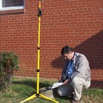
+PFF Posted December 5, 2008 Share Posted December 5, 2008 This should have been an ideal GPS site! I was searching for a triangulation station and two reference marks. I was at a large farm, on top of a low ridge, and the view to the horizon was excellent. Moreover, each reference mark has its own PID, with adjusted coordinates. After obtaining permission from the owner, I set off for the area near the barn. As I approached the main station, the pointer on my GPS unit would suddenly swing in a different direction. It's straight ahead 34 feet. No, it's to the left 51 feet. Nope, it's 27 feet to the right. The same thing happened when I looked for RM2, which was described as being 67 feet north of the barn. However, the GPS unit behaved properly while looking for RM1. The barn is a cinder block structure with a large tin roof. The roof slopes toward the north, in the direction of the station and RM2. [see photo, below.] I believe it was acting as a large "satellite disk", reflecting signals directly at the ground in the area of the disks. RM1 was at a sharp angle to the roof, and was a greater distance away. This might account for the stability of the GPS while searching for RM1. Eventually, I was successful, even though all three disks were recessed 1 to 3 inches. But it left me with some questions: 1. Have the professionals in our Forum ever experienced something like this? 2. Could it have been the barn roof? (A GPS receiver determines its position by measuring time differences from satellites. A multipath reflection certainly would throw off the timing--much like seeing a 'ghost' on a television which is hooked to an outside antenna. 3. Would it be helpful to note this in my report? Clearly, the site qualifies as being suitable for satellite observations, based upon the unobstructed view of the horizon. However, I suspect that GPS readings would be "all over the board", even when averaged over many hours. Oddly, I had a similar experience earlier in the day. I was at a station with Scaled coordinates, and I attempted to average readings over several minutes for inclusion in the NGS log. However, it would not pull in any tighter than 16 feet. I was at a bridge. At each end, there was a large, flat, vertical metal warning post. I moved to a position at a right angle to the post and the reading came down to 10 feet. As with the barn incident, I attribute this to reflected signals. -Paul- Quote Link to comment
Bill93 Posted December 5, 2008 Share Posted December 5, 2008 It'll be interesting to see what the pros say. My version would be: Suitable? Don't know In recovery text: "Clear view of sky but nearby metal roof appears to create serious multipath." Quote Link to comment
+jwahl Posted December 5, 2008 Share Posted December 5, 2008 Your problem may have been made worse by a weak or poor configuration of satellites. That is the number and location. I think survey grade receivers have more capability to filter out multipath by only using the first signal received for example. However it wouldn't hurt to pass on the information such as 'Location suitable for Satellite observations. 'Large metal barn roof nearby may create multipath issues.' or 'iron bridge structure overhade may create multipath problems'. Those things in particularly if they are not obvious in the aerial coverage could save a surveyor some wasted time. - jlw Quote Link to comment
CallawayMT Posted December 5, 2008 Share Posted December 5, 2008 Paul, Generally we are looking for an open horizon at 13 degrees in elevation from the earth up. If the barn is a tall structure and is above that 13 degrees from the monument position it can definitely cause some multipathing issues. Also, looking at your photo, the barn is in the southerly direction, which is generally where we find our stronger satellite signals. As Jerry Wahl points out, we have the software to look for signal issues and eliminate some of those. The best thing you can do, is state what you see and find and the rest is up to us if we read your station update and make the decision whether or not to use that mark. Happy hunting, Kurt Quote Link to comment
+GEO*Trailblazer 1 Posted December 6, 2008 Share Posted December 6, 2008 (edited) Finally found one of the images I was looking for. Purdue University CORS This has a cool chart for making notes at the station pg. 22. NGS Users Guide to GPS pdf I also made this if anyone would like to use it for noting at a station. Edited December 6, 2008 by GEO*Trailblazer 1 Quote Link to comment
AZcachemeister Posted December 6, 2008 Share Posted December 6, 2008 Man, that is a toughie! Strictly speaking, the 'unobstructed view of the sky 15º above the horizon' should be described as suitable. However, your results seem to be less than optimal with a HH2 receiver. While you may be able to qualify your experience in the body of your report, there is (as we all know) no option to discuss your results when entering your assessment of GPS observability at the site. I think that if I had this kind of experience, I would click the (Don't know) button, but state the details in my report. Really, you Don't Know exactly how a survey-grade GPSr is going to react at this site. Quote Link to comment
+PFF Posted December 6, 2008 Author Share Posted December 6, 2008 Excellent info! Thanks to all who responded. I am taking your suggestions. I'll mark it "don't know" for GPS Suitability, but I will put a note in the remarks. The upload to NGS will take place next week. Here are the drafts: EZ6032 EZ3831 -Paul- Quote Link to comment
Z15 Posted December 6, 2008 Share Posted December 6, 2008 (edited) Keep in mind a pro would occupy the station for a longer period of time. When we did positioning for our Highway projects we left the receiver collecting data for 3-5 hrs and each station was occupied 2x, at different times or different days. If station A was occupied in the AM, next time it would be PM or the next day AM or PM. Some got occupied 3x. Often I would spend all am (4-5 hrs) setting out 3 to 6 gps units over a large area. Set to turn on a say, 12:30pm and run for 5 hrs and turn off. I remove them faster. Once back at the motel, download the data to OPUS. OPUS would take about 5 min to compute each station. Next day do it over again. Edited December 6, 2008 by Z15 Quote Link to comment
+Ernmark Posted December 8, 2008 Share Posted December 8, 2008 ..interesting thread. I just now clicked on the links below: Excellent info! Thanks to all who responded. I am taking your suggestions. I'll mark it "don't know" for GPS Suitability, but I will put a note in the remarks. The upload to NGS will take place next week. Here are the drafts: EZ6032 EZ3831 -Paul- [begin hijack] ...so now all I can think of is that Paul spent all that time looking for that "STINKING RM 2" ! [/end hijack] Quote Link to comment
+Renegade Knight Posted December 8, 2008 Share Posted December 8, 2008 Were you standing under or near a power line at the time? Quote Link to comment

Recommended Posts
Join the conversation
You can post now and register later. If you have an account, sign in now to post with your account.
Note: Your post will require moderator approval before it will be visible.