wister6813 Posted September 26, 2008 Share Posted September 26, 2008 Not often that a C&GS disk is the topic of a article in the paper, yet today's Cedar Rapids Gazette describes what appears to be an unstamped disk in Cedar Rapids. It is part of a high water monument from the flood of 1929. http://www.gazetteonline.com/apps/pbcs.dll...69962/1002/NEWS Bob Quote Link to comment
+NorthWes Posted September 26, 2008 Share Posted September 26, 2008 Intriguing monument - nicely done compass rose on top. Unfortunately the mark doesn't appear to be in the NGS database. An area search on the north side of Cedar Rapids near the intersection of Ellis and Edgewood Roads turns up nothing similar at all, which is truly unfortunate for such a nicely done 'monumentation.' What's disturbing (pardon the pun) is the newspaper article author's suggestion to uproot the entire monument and move it downtown... Quote Link to comment
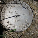
DaveD Posted September 27, 2008 Share Posted September 27, 2008 The marker in the middle is what is often referenced as a CWA mark. This and many thousands of other similar marks were set during 1933-1940 originally support by the Civil Works Administration and monitored by C&GS. Regrettably, most of the work done under this program was of sub-standard quality and the original records were never received by C&GS. Some of the states maintained their programs for several years after the CWA ceased to exist. I have the records for some of the work from Iowa so I will check into this one when I get back to the office on Monday. Quote Link to comment
Bill93 Posted September 27, 2008 Share Posted September 27, 2008 I sent a note to the author of the article, giving him a link to this thread. Quote Link to comment
foxtrot_xray Posted September 27, 2008 Share Posted September 27, 2008 What's disturbing (pardon the pun) is the newspaper article author's suggestion to uproot the entire monument and move it downtown... Actually, I read it that he wants the 'new' one - the 2008 monument - to be erected downtown. Quote Link to comment
+LSUFan Posted September 27, 2008 Share Posted September 27, 2008 (edited) That was a cool looking monument. When I read the "user comments" at the bottom of the page, there were several stating that this same newspaper had ran another article about this monument in 1993, with a lot more details on it in that article.(with possibly a picture of it being erected) I think it would be interesting to read that article on it also. Edited September 27, 2008 by LSUFan Quote Link to comment
AZcachemeister Posted September 28, 2008 Share Posted September 28, 2008 So for me the big question is how had this monument been hidden for so long? Was it revealed by erosion from the recent flood? Or, perhaps, had it been there all the time and nobody felt the need to mention it before? Quote Link to comment
+hogrod Posted September 28, 2008 Share Posted September 28, 2008 So for me the big question is how had this monument been hidden for so long? Was it revealed by erosion from the recent flood? Or, perhaps, had it been there all the time and nobody felt the need to mention it before? Check out the Comments posted below the story, a couple people mention it being in the paper during the flood of 1993, and the news article having allot more detail at that time. maybe someone could do some digging and find one of those old articles. Quote Link to comment
DaveD Posted September 29, 2008 Share Posted September 29, 2008 After a careful review of all the data in the NGS database, the horizontal and vertical control publications by the U.S. Geological Survey (USGS) and the 1940 report "Dubuque and Belle Plaine Loops Supplemntary Adjutment" of the Iowa Geodetic Survey under the Works Progress Administration (WPA), I have been unable to locate any information concerning the setting of this specific marker. The WPA documentation indicates that work was performed in the Cedar Rapids area during 1934. Additional documentation concerning the Civil Works Administration (CWA)/WPA efforts in Iowa indicates that several hundred monuments were set, but that the majority of these data were substandard and the data was destroyed sometime in the 1960's. Quote Link to comment

Recommended Posts
Join the conversation
You can post now and register later. If you have an account, sign in now to post with your account.
Note: Your post will require moderator approval before it will be visible.