+Minimike2 Posted November 13, 2009 Share Posted November 13, 2009 Indiana hasn't placed one yet (I think.) I placed a cache 560feet NE of the spot GC204Z7. Quote Link to comment
+Ernmark Posted December 5, 2009 Author Share Posted December 5, 2009 I don't think this one has been posted yet: Colorado WM12FJ posed by Team Nin Dawg Quote Link to comment
+Skyboy01 Posted January 24, 2010 Share Posted January 24, 2010 Florida's 2000 Center of Population is not geographically correct. The stone tablet says the actual center is 10.6 miles away east of Lake Buffum but that point is not easily accessible so it was placed in downtown Fort Meade. Now, to figure out how to post a photo. Skyboy01 Quote Link to comment
+Ashallond Posted January 24, 2010 Share Posted January 24, 2010 Who knows if Arkansas's ever got established. apparently that list doesn't, but I did find a contact name...may have to make a call on Monday. Quote Link to comment
Okie'sKid Posted January 24, 2010 Share Posted January 24, 2010 Mornin' all, Anyone out there know if Wyoming has set their's yet? Cheers, JCS Quote Link to comment
holograph Posted January 25, 2010 Share Posted January 25, 2010 Mornin' all, Anyone out there know if Wyoming has set their's yet? Cheers, JCS In Dec. 2005, I contacted Richard Muscio, President of the PLSW, and he stated that to his knowledge, no center of population monument had been set in Wyoming. Quote Link to comment
+buckmeadows Posted February 6, 2010 Share Posted February 6, 2010 The California COP disk is located along Intersate 5 at the southbound Buttonwillow rest stop in Kern county. The disk, estimated to be about eight inches in diameter, is located within a traffic island and sits about six inches above the asphalt pavement. The coordinates for the disk are: N 35º 25.033 W 119º 25.279. I am uncertain of how to include a photograph. Quote Link to comment
+Ashallond Posted February 8, 2010 Share Posted February 8, 2010 Who knows if Arkansas's ever got established. apparently that list doesn't, but I did find a contact name...may have to make a call on Monday. I sent an email, and have gotten no response at all. Quote Link to comment
+tzipora Posted February 26, 2010 Share Posted February 26, 2010 I was born and raised in Palmer, AK. I'm surprised that it is home to the center of population. It almost makes it sound like people live there! Quote Link to comment
Okie'sKid Posted March 13, 2010 Share Posted March 13, 2010 Here's the COP for Nevada. PID # DG4047 (2003) Quote Link to comment
Okie'sKid Posted March 14, 2010 Share Posted March 14, 2010 Here's the COP for Nevada. PID # DG4047 (2003) Forgot to mention, the Nevada COP is at the High School in Beatty. Quote Link to comment
+king.hubi Posted May 7, 2010 Share Posted May 7, 2010 (edited) And here is the 2000 Census State Center of Population monument for New Hampshire. It is located east of Route 3 in the front lawn at the Pembroke Town Library in Pembroke, NH. The disk sits in the top of a 1x1 foot granite stone. Coordinates are N 43° 09.011 W 071° 27.633. Until now it has no PID. I waymarked it, its waymark ID is WM8R63. King Hubi Edit to edit: Photo resizing Edited May 7, 2010 by king.hubi Quote Link to comment
+shorbird Posted May 10, 2010 Share Posted May 10, 2010 When this year's census has been completed, we will then have 50 new COP marks to search for(after they are set). Does anyone know how many years ago they started setting these marks? I noticed a couple in this thread which used the 1990 census. Quote Link to comment
AZcachemeister Posted May 16, 2010 Share Posted May 16, 2010 When this year's census has been completed, we will then have 50 new COP marks to search for(after they are set). Does anyone know how many years ago they started setting these marks? I noticed a couple in this thread which used the 1990 census. That would be nice, but given the current economic conditions I would be surprised if any new plaques get created. Quote Link to comment
+Ernmark Posted June 22, 2010 Author Share Posted June 22, 2010 We now have the S. Carolina monument: Waymark WM936D - courtesy of ChapterhouseInc. Quote Link to comment
glorkar Posted July 15, 2010 Share Posted July 15, 2010 I got the Wisconsin one. Quote Link to comment
+secondgunman Posted April 9, 2011 Share Posted April 9, 2011 Arkansas' Center of Population monument has been set. It can be found at 35° 04.620' 094° 32.643'. I've posted the details and photos to Waymarking and am waiting for it to publish there. http://www.Waymarking.com/waymarks/WMB5Z1_Arkansas_2000_Census_Center_of_Population_Marker Quote Link to comment
holograph Posted April 13, 2011 Share Posted April 13, 2011 Arkansas' Center of Population monument has been set. It can be found at 35° 04.620' 094° 32.643'. I've posted the details and photos to Waymarking and am waiting for it to publish there. http://www.Waymarking.com/waymarks/WMB5Z1_Arkansas_2000_Census_Center_of_Population_Marker I've been hoping that someone would track that one down. When I was researching COP markers for the benchmarking web site, and found that one might be in a place called "Toad Suck Park", it was just too good. Now we all need the back story about the name "Toad Suck". Any information? Quote Link to comment
tosborn Posted April 13, 2011 Share Posted April 13, 2011 (edited) The explanation on Wikipedia seems to be the most repeated version. But a while back I came across this link which offers some alternative theories. Edited April 13, 2011 by tosborn Quote Link to comment
+Ashallond Posted April 14, 2011 Share Posted April 14, 2011 No definitive reason for the name, but the two linked stories are the most known. Quote Link to comment
+dukeofurl01 Posted April 15, 2011 Share Posted April 15, 2011 Does every state have one of these? Quote Link to comment
kayakbird Posted May 18, 2011 Share Posted May 18, 2011 (edited) Sunday morning Okie'sKid and I rendezvoused in Cascade to finally go after Montana's 2000 COP (DH4417) at Camp Baker, which is a long way from any kind of population except right now during the Smith River launch period. Don't think that the 2010 census will require a new monument. CAMP BAKER Managed to gather up a few 1934's along the way. RW0170 kayakbird Edited May 18, 2011 by kayakbird Quote Link to comment
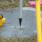
+LSUFan Posted May 18, 2011 Share Posted May 18, 2011 (edited) OK, since ya have revived this topic, I got to looking at the one in Louisiana again. Another benchmarking buddy of mine, keeps talking that we need to run down there and post a recovery on it one weekend. However, when I looked at the datasheet for it, there are photographs included. These may be from when it was monumented, but not sure. The concrete does still look fairly new in the photos. http://www.ngs.noaa.gov/cgi-bin/ds_mark.prl?PidBox=DE5745 There are two pics, that don't seem to go with this disk at all though, and are showing up on the datasheet for it. One appears to be for a triangulation station reset named Garner (which I can't find in my active database of Louisiana benchmarks)....and the other seems to be some kind of cooperative disk between the power squadron and NOS. Anyone have any ideas on why these would be showing up on the COP datasheet for Louisiana? http://www.ngs.noaa.gov/cgi-bin/get_image.prl?PROCESSING=get_figure&IID=2630 http://www.ngs.noaa.gov/cgi-bin/get_image.prl?PROCESSING=get_figure&IID=2629 Oh Yeah, and here is a pic from the datasheet of ours. Photographer Unknown (right now) Edited May 18, 2011 by LSUFan Quote Link to comment
+Ernmark Posted October 17, 2011 Author Share Posted October 17, 2011 (edited) Missouri: DE6442 Waymark by BruceS Edited October 17, 2011 by Ernmark Quote Link to comment
TillaMurphs Posted October 17, 2011 Share Posted October 17, 2011 However, when I looked at the datasheet for it, there are photographs included. These may be from when it was monumented, but not sure. The concrete does still look fairly new in the photos. http://www.ngs.noaa.gov/cgi-bin/ds_mark.prl?PidBox=DE5745 There are two pics, that don't seem to go with this disk at all though, and are showing up on the datasheet for it. One appears to be for a triangulation station reset named Garner (which I can't find in my active database of Louisiana benchmarks).... Anyone have any ideas on why these would be showing up on the COP datasheet for Louisiana? http://www.ngs.noaa.gov/cgi-bin/get_image.prl?PROCESSING=get_figure&IID=2630 Sorry LSUFan - a bit late on reading your post. However, that picture appears to belong to: EZ0760 in North Carolina. Quote Link to comment
+LSUFan Posted October 17, 2011 Share Posted October 17, 2011 Sorry LSUFan - a bit late on reading your post. However, that picture appears to belong to: EZ0760 in North Carolina. Thanks for finding out where Garner is. It's a good ways from Louisiana. I am just guessing, that it is some kind of data entry error, for the reason those two disks are showing up in the photos for Louisiana's COP. Quote Link to comment

Recommended Posts
Join the conversation
You can post now and register later. If you have an account, sign in now to post with your account.
Note: Your post will require moderator approval before it will be visible.