CallawayMT Posted March 2, 2008 Share Posted March 2, 2008 I was recently fortunate enough to go on a vacation with my wife to Kauai, Hawaii; naturally I had to find at least a few benchmarks while enjoying a mid-winter warm up. We were on the north side of the northernmost island of Kauai, while visiting the Kilauea Lighthouse: Kilauea Light Intersection Station I noticed in the data base a long lost tri-station in the area and thought about Holograph's extreme station listings and figured that this must be the northernmost point for the state of Hawaii; you can even look on his map and you won't see anything further north. Well I learned otherwise, a handful of marks showed up much further north and also west from this island. I had to do a little research and learned that the map that we all see for the state of Hawaii neglects to show us the whole Hawaiian chain. This extra bunch of Hawaiian Islands is called "Northwestern Hawaiian Islands" and is mostly uninhabited and considered a Marine National Monument. This would explain why they are not on most maps, due to the fact that there are no tourist areas as far as airports, stores and tax base; even though this batch of islands is under the jurisdiction of the State of Hawaii. Maybe I was the only person who did not know this, but I thought I would share what I learned today. CallawayMT Quote Link to comment
holograph Posted March 2, 2008 Share Posted March 2, 2008 (edited) Most maps, mine included, don't show the minor islands because the inset would be almost as large as the continental US, or alternatively reduced in scale so that all the populated Hawaiian islands would be shrunken to insignificance. The Pacific is a BIG ocean. You can look at the northernmost station for Hawaii and click on the Google maps link. You will see that the northernmost station of Hawaii is northwest of Midway island. DE5247 (Google map link). edit: Here are the comparative sizes of Hawaii and the continental US: Edited March 2, 2008 by holograph Quote Link to comment
+Klemmer Posted March 2, 2008 Share Posted March 2, 2008 CallawayMT, don't tell me you missed the opportunity to recover the furthest west of any GEOCAC recovery? See Holoscene's "Notable Recoveries". I was quite surprised to find out that several years ago that I had the most western GEOCAC recovery, when I recovered the NAWILIWILI HARBOR LIGHTHOUSE (TU1763). The harbor is on the EAST coast of Kauai, so there is a whole island's worth of marks to recover to move that record west. Hope you did! Unfortunately, I didn't know it at the time. Gotta get back there again sometime. So maybe I lost my record? I had looked at those islands several years ago. Interesting. BTW: If you are looking for the marks on the NGS site, they are listed under "MIDWAY ISLANDS", like it is a state, despite (as you said) that they are under the jurisdiction of the state of Hawaii. There is also a category for "PACIIC ISLANDS", "JOHNSTON ATOLL" and a few other misc outlying area (like Guam, etc which are over the Date Line). So it could get very "technical" (legally), what the most western US benchmark really is (if anyone would really care). Johnston Atoll? Holoscenes site has it as TT6243 in Alaska, which is listed as longitude W187°, which I don't really understand. Shouldn't that be E007°? It it an NGS thing? Then by that logic, Alaska must have the furthest East one also, not Maine??? Hope I didn't start something here.... Quote Link to comment
+seventhings Posted March 2, 2008 Share Posted March 2, 2008 CallawayMT - I did not know that either. Interesting. Also very enlightening is holograph's depiction of the scale of the entire chain of islands relative to the lower 48. Kudos to you on the recoveries in Hawaii. Double kudos to the long-suffering Mrs. CallawayMT for putting up with your benchmark hunting on (what should by all rights have been) a very special vacation. Will Quote Link to comment
DaveD Posted March 3, 2008 Share Posted March 3, 2008 NGS, in partnership with the U.S. Fish and Wildlife Service did a GPS project across these islands in 2001. See DE5195, DE5202, DE5228, DE5231, DE5247, DE5248 and DE5249. The survey crew had to freeze their clothing and change it before going on each island. Quote Link to comment
68-eldo Posted March 3, 2008 Share Posted March 3, 2008 These stations pose a problem for me. They are all in the county of Honolulu which I have been working on. The last couple of years I have had personal business to tend to so I have not been able to do much bench mark hunting. But when I get free, my nephew is a boat captain and makes trips to the northwest islands on occasion. Maybe…. As to Klemmer’s question about TT6243, the international date line zigzags back and forth so that certain lands stay in the same date as the rest of the country. Alaska is one place the date line zags west. I’m guessing that they also extend the longitude beyond 180 degrees also so that the marks stay in the same hemisphere. I presume CallawayMT will be logging those marks with NGS? Glad to see some progress on the outer islands. Quote Link to comment
CallawayMT Posted March 3, 2008 Author Share Posted March 3, 2008 I presume CallawayMT will be logging those marks with NGS? Glad to see some progress on the outer islands. 68, Now you are trying to turn this into work for me; I will look at my recoveries and see if any need to be reported. I guess that would be the only way to take that most westernmost away from Klemmer, yes I did definitely get further west than you, and I did it from shore and air, not from some cushy cruise boat. Seven - Now why would you think that the Mrs. didn't enjoy looking(waiting) for some awesome marks with me, it's not like there is anything else to do out there in the middle of no-where. CallawayMT Quote Link to comment
+Klemmer Posted March 3, 2008 Share Posted March 3, 2008 CallawayMT: Cushy? Well, yeah! But did you go zip-lining across the river, and jump off the Kipu Falls? Feel free to grab my record. I've had it long enough. But I may steal it back someday.... 68: Yeah, that makes sense. But still, does that make it furthest west? I dunno.... I guess either one is equally inaccessible to the average benchmark hunter. Good luck getting out there! Quote Link to comment
2oldfarts (the rockhounders) Posted March 3, 2008 Share Posted March 3, 2008 I know several ladies that would just love the chance to go along and see some marks on any of those islands. And you are correct, there are many areas on this planet that qualify as "it's not like there is anything else to do out there in the middle of no-where". I would like to see some of those pictures that you took of the surrounding areas in the picture contest thread, pretty please. And a couple of you and/or your wife enjoying yourselves on your trip here in this thread, maybe? I had no idea that the Midway Islands were considered "part of" Hawaii. We are never so old as to not learn something every day. Shirley~ Quote Link to comment
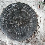
CallawayMT Posted March 3, 2008 Author Share Posted March 3, 2008 (edited) CallawayMT, don't tell me you missed the opportunity to recover the furthest west of any GEOCAC recovery? Hope I didn't start something here.... Klemmer, I did recover this one, well maybe more than one: It should count, since the sign does say the westernmost. CallawayMT Edited March 3, 2008 by CallawayMT Quote Link to comment

Recommended Posts
Join the conversation
You can post now and register later. If you have an account, sign in now to post with your account.
Note: Your post will require moderator approval before it will be visible.