+t8r Posted February 15, 2008 Share Posted February 15, 2008 (edited) Able and baker appear to be 25 miles from published coordinates if i can still follow directions at all. The coordinates are just south of Hammett and the to-reach leads several miles southwest of Bruneau. Going out of Bruneau and then south is Idaho 51. Go the right number of miles (7.5) and you come to a track road leading west at 42° 47.362' by 115° 54.747' . This track road follows the south edge of a farm field. BTW able's directions say turn left, west. Left, when you have been going south is east, I think. Baker's directions say only go west at this point. This shows up good on google earth. I spent several hours looking around that area to no avail. The area around here that is not farmed would best be described as badlands. There are dozens of featureless plateaus and drainages here and the only way to know if you have found the correct ones is when you find able and baker. There are also numerous track roads that fit the vague descriptions given. See google earth. This has really got me bugged. As soon as weather permits i plan to take my camper out there and stay a day or 3 and do some extreme benchmark hunting. Edited February 15, 2008 by t8r Quote Link to comment
+Holtie22 Posted February 15, 2008 Share Posted February 15, 2008 Good catch t8r, there is certainly something amiss here! I would be inclined to believe that the numbers are right, especially since Able and Baker show up on the USGS topo maps in very credible locations. It would appear that the to-reach descriptions got mixed up with some other stations (that I can't find on the topos) when the database was being constructed. My advice would be to search for Able first, since it is located on a prominent point, and Baker had a DNF back in 2004. BTW they serve as each others' Azimuth Mark, so they should be intervisible. Quote Link to comment
CallawayMT Posted February 15, 2008 Share Posted February 15, 2008 T8r, Both tri-stations show up on the USGS quadsat their reported coordinate positions. This is a discussion that we have had around here; what will 99% be wrong when there is an error? The to-reach descriptions were hand transcribed by multiple people multiple times over the years and have the highest probability of being messed up in some way. I am amazed that you are so diligent about following the description without doing a little more research. I generally plot all of the marks and check out the route by visually looking at topo and aerial imagery before I even look at the to-reach description. For horizontally adjusted coordinates I may never look at the desription until I get onsite. I would be willing to bet that those stations are gnats on to the coordinates listed by NGS. You shouldn't have any problem finding them in the spring, unless they have been disturbed. Good luck, CallawayMT Quote Link to comment
+jwahl Posted February 15, 2008 Share Posted February 15, 2008 The general description to Baker ends up in credible locations for a trig station in several possible locations about a mile south of 'Jack'. One wonders if additional locations were scouted out, but never used, and somehow the descriptions got mixed up. Presumably the USGS quad depiction and the published coordinates are the correct ones, but until you find one of them, you won't know for sure. I could give you my candidates for the Baker description if you want, but would try the published location first. - jlw Quote Link to comment
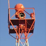
+t8r Posted February 27, 2008 Author Share Posted February 27, 2008 Found Able and Baker today. The coordinates are dead on and the descriptions are in error as suggested. Can someone come up with an idea on those stampings? Able is stamped M4A-41 Baker is stamped M4A-42 BAKER ABLE Quote Link to comment
Bill93 Posted February 27, 2008 Share Posted February 27, 2008 (edited) I'd say you found NV1190 and NV1188. You did not find ABLE and BAKER. When I found a mixup, the NGS kept the PID and the position/elevation data together, and made whatever changes were necessary in the designation, stamping, to-reach, etc. This was different from finding a typo in the coordinates of an elevation bench mark which are not "data" but merely description. My case was finding a disk that matched the description under old data sheet (GC) MH0702 with coordinates that didn't match, and NGS decided I had found MH0753 (NGS) which previously was not published but had those coordinates. Since there appears to be no permanent marker at the coordinates of MH0702 they made it non-published, and changed the designation to what it should have been. I have an interesting collection of printouts of MH0702 as it went through multiple changes. It probably means there are/were markers out there somewhere matching the descriptions on the data sheets, maybe/maybe not findable, stamped ABLE and BAKER and NGS knows about them but doesn't have good enough data for them to publish data sheets. You might want to ask Jerry Wahl for the information he was suggesting, to help look for disks with the ABLE and BAKER stamping. Have you run into any other markers previously like the M4A series in the pictures? If so, you might get a clue from who set them, when, etc. If you get Dave Doyle interested, he may be able to find more information. Even if he can't find anything on the M4A series, he might find azimuth and distance information for some station near JACK or others in the area of the to-reach on ABLE and BAKER. They had to have more sightings than listed on these data sheets. He once told us that when the data base was created they did not copy all the box score information off the paper records when it did not appear to be useful to local surveyors. That additional information might help identify the phantoms here. Edited February 27, 2008 by Bill93 Quote Link to comment
+Klemmer Posted February 27, 2008 Share Posted February 27, 2008 Are they really "for sure" NV1190 and NV1188? The disk markings are different, and (as I understand it) the to reach directions are totally way off. Your handheld GPSr was within normal limits for a consumer handheld unit. So you were in the right area (give or take 25 feet or so) and I would say "OK" for a Geocaching find. But for an NGS find log? Hmmmm.... I dunno. Without the exact marking on the datasheet, or a survey-grade GPS confirmation, I wonder. It is possible that Able and Baker discs (C&GS discs marked as such) were nearby, but destroyed, and a local agency set what you found "near" where Able and Baker disks were (and didn't document them with NGS). Or, what you found could be an undocumented reset of Able & Baker (not uncommon). Able & Baker disks were monumented by C&GS. I really doubt they would have set what you found (but anything is possible). Do they look old enough? I dunno.... Quote Link to comment
Bill93 Posted February 28, 2008 Share Posted February 28, 2008 Klemmer, you make a good point that we aren't absolutely certain these are NV1190 and NV1188. It does seem pretty likely. They sure aren't ABLE and BAKER. It would help to know more about the location they were found. Is there any indication of activity nearby that could have disturbed them? I see on one map there is a Missile Base Road east of Hwy 51 a little further south than described for ABLE and BAKER. That plus the names being part of the 1940'a-50's military phonetic alphabet makes it likely some of the work in the area was done for the military. We've seen mention of other artifacts left by the military for which the location data was classified. That may make the mystery hard to unravel. What is in the area now that is military related? Quote Link to comment
+t8r Posted February 28, 2008 Author Share Posted February 28, 2008 I certainly thank all for any advice I can get here. I do not intend to post anything with NGS with only the present evidence. First of all I am totally obsessive about getting the true answers on anything I investigate. My first posting on this forum was last year at this time when I set out to do some benchmarking and decided that there was no use logging tri stations without attempting to find and photograph all the pieces of each. I eventually sat down and read old posts in the benchmarking forum. I probably spent 30 hours reading that stuff. Now to Able and Baker; Originally, in my innocence, I thought that the description might be correct and the coordinates wrong. I started this thread with hope that someone might have some insight as to how that numerical error could have occurred thus revealing what the error might have been. The post by Holtie22 made me think that I might better look where the coordinates say these stations should be. “Good catch t8r, there is certainly something amiss here! I would be inclined to believe that the numbers are right, especially since Able and Baker show up on the USGS topo maps in very credible locations. It would appear that the to-reach descriptions got mixed up with some other stations (that I can't find on the topos) when the database was being constructed. My advice would be to search for Able first, since it is located on a prominent point, and Baker had a DNF back in 2004. BTW they serve as each others' Azimuth Mark, so they should be intervisible.” Last fall I drove and walked the described “to reach” somewhat extensively and found nothing. Yesterday I went to the coordinate area, armed with a clipboard full of map printouts, NGS datasheets and my benchmarking backpack and all included toys. I know this area very well and in fact drove between able and baker nearly every day of the 1975 growing season, on the road that shows as a 4wd trail on the 7 1/2 minute topo. With the land contours and photos in hand and in mind, I walked right to the location of Baker and marked where the GPS said it might be. Then I went to work with the metal detector and found the pipe with the copper washer and stamping lying on It’s side, under 6” of sand, just 10’ north of my mark. I did not stop there but detected approximately a 50’ radius around my mark. The sky was clear and the area has nearly 180° X 360° bubble of view. It is several miles to any ground that is appreciably higher than this. The GPS was claiming 13’ accuracy. As I mentioned in my log this area is shifting sand and that likely had something to do with the condition of the station. Now I took the usual pictures and reburied the pipe/washer as I had found it so that some future benchmark hunter might have some fun finding it, and off to find able. As a final check I ran the GPS with the posted coordinates and the pipe was only 5’ to the north after about a time lapse of about 1 ½ hours Able was a much easier find as the ground around it is not moving like that around Baker. As I approached on foot I could see a bunch of basalt boulders lying around and some rotted wood that is commonly found around tri stations in this dry desert area. When I worked in this area in ’75 there were a lot of wood and cloth targets in the area that were still standing. I knew that they were used by surveyors as an aid to triangulation but did not know about tri stations at the time. It is common to find the pieces of these scattered around tri stations as well as boulders and wires that were used to stabilize the targets. The GPS showed that Able should be right in the middle of this group of boulders. A little looking around with the metal detector revealed the pipe/washer slightly under the surface a couple of feet from the GPS. Like with Baker I detected about a 50’ radius and found nothing more than rotting wood with nails in it. I use a manure fork for digging and probing. It works well with it’s 5 tines. That the description is screwed up is not arguable. If the “to reach” is from some other station, then the rest of the description is likely wrong, including the info about the stampings. The claim of concrete cylinder and stampings is in the same paragraph with the “to reach” for both stations. I am not surprised that these would not be standard tri station discs. The names don’t fit the area. All other stations around here refer to some landmark in the area for a name. That they could be military is possible. All the area south of the Snake River here was an aircraft gunnery/bombing range in the’50s. I possess several 50 cal live rounds that were harvested with potato harvesting machines in the ‘70s when much of this area was opened to desert entry. The Indian Cove farm area immediately to the west along the river was opened to entry around 1910-1920. Is it possible that these were established at that time and became monumented in 1958? They command a good view of that whole area. Is it possible that the surveyor involved in this had a very busy season in ’58 and referred to his coffee stained field notes much later and just got a little confused? Perhaps some tragedy befell the surveyor in the midst of that job and some other folks back at the office tried to pick up the loose ends. Quote Link to comment
+Klemmer Posted February 28, 2008 Share Posted February 28, 2008 t8r: Very interesting situation. My compliments on your handling of it. Other than more research into the C&GS (now NGS) archives, I can't really suggest anything you haven't done. Hopefully Dave D can help. Oh, one thing: is there a County Surveyor you could contact? Maybe their database or archives (possibly on-line) could shed some light. Out here (Orange County CA), that has helped me iron out a few mysteries. They have a great on-line database. Quote Link to comment
DaveD Posted February 28, 2008 Share Posted February 28, 2008 I know the guy who set these marks, William (Bill) Husemeyer. If he said he set stations stamped ABLE and BAKER, then that's what he set. Bill was definately old school C&GS and wouldn't set the type of marks in the pictures. It is obvious that the descriptions are incorrect. Since you didn't find the marks called for, I would recommend that you post a recovery to describe the problem with the description and that the marks were not recovered. Quote Link to comment
+Klemmer Posted February 29, 2008 Share Posted February 29, 2008 Now there's a definitive answer! That's what's so great about having NGS follks like DaveD to give us the straight scoop. Thanks, Dave! Quote Link to comment
+t8r Posted February 29, 2008 Author Share Posted February 29, 2008 Yesterday I journeyed to Murphy, the Owyhee county seat, 160mile round trip, for the express purpose of looking at recorded surveys in the area. Thought i might find one that referenced these stations. No luck. The only thing they have on record is survey maps; none in that area older than 1990. I guess the next thing to do is go back to the area in the description and spend a lot of time following all likely track roads in the area. BTW look at Murphy, id on google earth. I don't know if it's the smallest county seat but the population is not listed. Perhaps 75. There is one business, a convenience store. The air strip is so the sheriff can fly around looking for rustlers. Quote Link to comment

Recommended Posts
Join the conversation
You can post now and register later. If you have an account, sign in now to post with your account.
Note: Your post will require moderator approval before it will be visible.