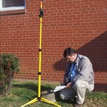
+PFF Posted January 10, 2007 Share Posted January 10, 2007 It was sunrise on the morning of January 9th, and I was running ahead of schedule for a rendezvous with the Boundary Specialist from the South Carolina Geodetic Survey. We were to meet at a country church on US-1 and would spend the day searching for old granite markers along the state line. I had logged four benchmarks along my route, but still had 15 minutes to spare. I pulled onto the shoulder of US-1, about a quarter-mile south of the church. I was just getting ready to look for station MARLBORO (EB3669), when Alan-Jon pulled in behind me in his official S.C.G.S. Jeep. Until that moment, we had only communicated by E-mail and telephone, and had never met, face-to-face. Nevertheless, we sprang into action like a well-oiled machine. We agreed on the general area to search, and he used his machete to clear brambles, while I operated the metal detector. Within ten minutes, we had recovered the station and were checking the reference distances with his several-hundred-foot tape measure. After making notes for the subsequent recovery report, we spent the next seven hours hiking segments of the border--with a break for lunch about 1 PM. What a great opportunity it was to see a professional at work! Alan-Jon is patient, methodical, and literally leaves "no stone unturned". Meanwhile, he enjoyed hearing about GEOCAC's impressive recovery statistics. And he really liked the Radio Shack 3300 metal detector, with the digital indicator showing the type of metal. One other thing that impressed him was seeing how corn starch brings out the lettering on a disk. "I have some of that at home," he told me. "I'll be carrying it with me, in the future!" By the way, I found a brand-new benchmark (stamped 2007) about 200 feet from MARLBORO. That also was a milestone, of sorts. It is unusual to find a current-year benchmark--especially on the 9th of January! I resisted the temptation to scratch my initials into the cement. It would be too easy to track me down! -Paul- Alan-Jon Zupan of S.C.G.S. prepares the Trimble GPS receiver to take a reading. (Photo by PFF.) Quote Link to comment
ArtMan Posted January 10, 2007 Share Posted January 10, 2007 Paul, Can you add a little info about Alan-Jon's GPS gear and how it's used? Does it provide real-time data, and to what level of precision/accuracy? How long does he collect data at a location? What kind of post-processing is done? Most of us have never had the opportunity to spend a day with a pro, and I think many of us are curious about survey- and geodetic-grade GPS equipment and its use. -ArtMan- Quote Link to comment
+PFF Posted January 10, 2007 Author Share Posted January 10, 2007 Hi, ArtMan: He explained a few things--but there was a lot of mysterious typing on a touch screen, throughout the day. Here's what I know: 1. Waypoints cannot be added in the field. They must be downloaded from a computer. 2. Readings in the field are collected for ten minutes. The long black pole has a pointed end, for placing it at a precise spot. The silver part of the pole (beneath the antenna) is telescoping, and is calibrated in meters. I didn't realize this until the end of the day when we took a reading at a property corner, under a canopy. Alan-Jon raised the antenna to a total height of about 7 feet, and he recorded the height in his records. (I joked that this was similar to "height of light above station".) 3. Most of the time, we were in motion; and he kept the unit collapsed to an overall height of 5 feet. It was a handheld pole--not attached to a backpack. Thus, one hand/arm was occupied whenever the unit was in use. There were times when he put it down so we could explore dense areas more easily. Otherwise, he had it in his hand the entire time. 4. He was able to give me a reading to several decimal points on the SECONDS figure, directly from the machine, but he says the REAL accuracy comes from post-processing, back at the shop. It appears that a COORS-like network is assembling correction data, constantly. This later would be applied to his field reading, based upon the precise time the reading was taken. [see #6.] 5. At times he grumbled about having only a few satellities--even though I had plenty of active birds on my Garmin. He also made comments that certain times of the day are not good for readings. I don't know whether this refers to specific hours, or to the ever-changing constellation. 6. South Carolina is working toward a network which will transmit the corrections to personnel in the field, so that real-time, precise readings will be possible. 7. It must have a hefty battery. We went into the field at 9AM, and finished at 5PM. There was about an hour and a half of travel time, when the unit was stored in the back of the Jeep. For the remaining 5.5 hours, the unit was in operation, and Alan-Jon never mentioned being concerned about the battery level. This device must be a power hog, with all the electronics. But it did not appear to be a problem. 8. In addition to marking waypoints in the field, the device was able to take us to the pre-loaded points, just as with a consumer-grade GPS receiver. Alan-Jon was calling out distances to the target, so he was getting instant readings of some kind. (But he did not have a "bread crumb" feature--so it was I who got us back to the car on several occasions--heh, heh.) 9. At one point, he checked with me to see which way was north so he could orient the antenna properly. He said that was the former protocol, but I got the impression that it might not be necessary with the current generation of equipment. Nevertheless, I seized upon this as an opportunity to tease him, a bit. "Shouldn't the device KNOW which way is north?' I asked. "Isn't this like the Psychic Hotline asking your name when you call?" -Paul- Quote Link to comment
Z15 Posted January 10, 2007 Share Posted January 10, 2007 (edited) At times he grumbled about having only a few satellities--even though I had plenty of active birds on my Garmin. He also made comments that certain times of the day are not good for readings. I don't know whether this refers to specific hours, or to the ever-changing constellation. Just having a bunch of SV's is not neccessarily always good. Its the geometry of them that make for a good survey grade solution. Survey grade GPS like this one are dual frequency while common recreational one are not. Dual frequency units have 2 signals to reconcile wherease your handheld only use one. Freq, 1 sends data and freq 2 sends data, the rcvr then compares the data and if they don't match exactly, its keeps processing till its finds a predetermined length of time that they do. As one instructor referr to the signal as turtles, freq. 1 send down 1000 turtles, one every 5 sec's. Freq 2 send down only 998 in the same time frame for whatever reason, leaf, tree or atmosphere obstruction. No solution is recognized by the onboard software and it continues to collect data till is gets a specified packet of data that match on both freg's that give a solution, all controlled by the software. The result if more precise positioning. It would cost 10-50 more for a handheld to have this capability. The batteries for that Trimble likely cost more than your Garmin GPSr. Edited January 10, 2007 by Z15 Quote Link to comment
CallawayMT Posted January 11, 2007 Share Posted January 11, 2007 Paul, Judging by the photo, that looks like a GIS or Resource grade unit; these are getting more high-tech and higher precision all the time. The antenna is a zephyr antenna, but I do not recognize the receiver, which can be seen on the far side of the rod; which is why I believe that it is a resource grade unit. He is collecting his data in a Trimble or TDS Recon data collector. These newer resource units can pick up both L1 & L2, which are used for post-processing of the survey data. With post-processing it is possible to get these types of units down to the 10-20 centimeters of accuracy; out on the ground he may have been getting 30 centimeters with WAAS and good geometry. The Lithium-Ion batteries will run well with the warmer temperatures and will also run longer while not actually collecting data. By the way, it is possible to enter geodetic coordinates in the field through the data collector. It sounds like you had a good learning experience. CallawayMT Quote Link to comment
68-eldo Posted January 11, 2007 Share Posted January 11, 2007 One thing I am curious about is how does this receiver get that kind of accuracy when the antenna is 5 feet or more above the point being measured? If the antenna is not precisely above the mark then the measured point would be wrong. Also I believe the length of the pole would also be important to the calculations. Quote Link to comment
CallawayMT Posted January 11, 2007 Share Posted January 11, 2007 One thing I am curious about is how does this receiver get that kind of accuracy when the antenna is 5 feet or more above the point being measured? If the antenna is not precisely above the mark then the measured point would be wrong. Also I believe the length of the pole would also be important to the calculations. 68, The height, or length as you stated is improtant and that is why Paul mentioned that he had been putting the height of the rod in when it did change. The software uses the rod height to calculate the elevation down to the point. Remember this is a resource GPS and elevations are going to be an approximation; I doubt that Trimble will even state what the elevation accuracy is for this unit. I would expect it to be in the neighborhood of ±10', but that is pure speculation. As to his horizontal accuracy, that is going to be relative to how accurately he held the rod plumb. Generally you use a bi-pod to keep the rod plumb for the GPS session while using a rod; for static survey grade sessions, the best method is to use a tripod. For precise measurements it is also a function of the calibration of your equipment, as in checking to make sure your rod is truly plumb. So you are right, if the antenna is not precisely over the point the measurement will be wrong. CallawayMT Quote Link to comment
+BuckBrooke Posted January 11, 2007 Share Posted January 11, 2007 (edited) Paul, in regards to time of day, the two things that might affect the signal are constellation geometry (as you said) and ionospheric turbulence/interference. 1) For geometry you want the satellites to be well spaced, not tightly clustered. The more tightly clustered the satellites in the sky, the more redundant the physical solutions, because the circles created by the solutions nearly overlap; thus, your positional accuracy is worse. 2) With a little bit of a guess regarding the ionospheric interference issue, we know that the GPS signal is around 1.2 and 1.6 GHz (24 and 18 cm wavelength), in L band (thus the L1/L2 and so on designations). These frequencies go through the ionosphere, but there's turbulence, interference and reflection (radio skip transmitting bounces off the ionosphere) The ionosphere expands and is more disturbed as it's heated by the Sun during the day, and cools off/contracts rapidly in the evening. So, I would guess that the best time to observe during a day is midnight to 8 AM or so. Even though as mentioned much of the ionospheric problems can be corrected by dual frequency comparison, I bet accuracy does degrade during the day. Also, the winter's probably better than the summer, because there's less solar heating of the atmosphere during the winter. Steve Randall talked about making GPS observations in the middle of the night, though it was probably more for satellite geometries. Edited January 11, 2007 by BuckBrooke Quote Link to comment
+Holtie22 Posted January 11, 2007 Share Posted January 11, 2007 Here's a site that will give you a taste of some of the technical aspects of GPS. GPS Overview Quote Link to comment
+PFF Posted January 11, 2007 Author Share Posted January 11, 2007 Hi, Gang, Great comments, and very good supplemental information. Thanks! -Paul- _____________________________________ We were talking with land owners to see if they were aware of the 1905 boundary markers. One man listened to Alan-Jon's description and said, "Go to the end of the dirt road. Straight ahead, in the woods, is what you're looking for." Knowing there were some cement boundary markers in that area, Alan-Jon asked for a confirmation that the man had seen a granite monument. "Yep," the gentleman replied. "It's stone." We followed the directions and ended up a cement post. As we laughed, I remarked, "This proves you should never take concrete for granite.......and that's my last bad joke of the day." "I'll hold you to that," Alan-Jon responded. Quote Link to comment
68-eldo Posted January 12, 2007 Share Posted January 12, 2007 68, The height, or length as you stated is improtant and that is why Paul mentioned that he had been putting the height of the rod in when it did change. The software uses the rod height to calculate the elevation down to the point. Remember this is a resource GPS and elevations are going to be an approximation; I doubt that Trimble will even state what the elevation accuracy is for this unit. I would expect it to be in the neighborhood of ±10', but that is pure speculation. As to his horizontal accuracy, that is going to be relative to how accurately he held the rod plumb. Generally you use a bi-pod to keep the rod plumb for the GPS session while using a rod; for static survey grade sessions, the best method is to use a tripod. For precise measurements it is also a function of the calibration of your equipment, as in checking to make sure your rod is truly plumb. So you are right, if the antenna is not precisely over the point the measurement will be wrong. CallawayMT Thanks Callaway. I assume there is a bubble level or some such to show the rod is plumb. Quote Link to comment

Recommended Posts
Join the conversation
You can post now and register later. If you have an account, sign in now to post with your account.
Note: Your post will require moderator approval before it will be visible.