


A tapeworm
-
Posts
62 -
Joined
-
Last visited
Posts posted by A tapeworm
-
-
You guys are ANIMALS! I hope the rock face isn't really as steep as it looks in the pics!

It reminds me of those climbs on Mt. Desert Is. @ Acadia Nat'l Park - I get nauseated just thinking about them! [imagine barfing smilie here!]
-
-
Many thanks to John and Shirley for all of their hard work, putting this contest together and going through all of the submissions from so many participants. It was fun!

Right-o !!!
In addition to simply encouraging me to go hunting, I learned about & experimented with several programs/tools to make hunting easier. Thanks!
-
-
-
Couldn't log yesterday, because gc.com was so infernally slow!
Still is!
How many finds can 2/3 Marine be posting?

-
-
Sometimes, its grafitto.
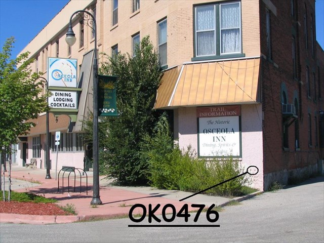
Now THAT'S cool! Much more exciting than, for instance, OK0476, which is painted merely a disturbing shade of pink.
Looks like a new contest topic: ninja hunting for camoflaged BMs!
-
(I often feel like I'm running around behind a tapeworm.)
... And he says that with a straight face!

-
I usually print out the page anyway so I have the written information. I don't use GSAK for anything but getting the coordinates into my GPS.
That's essentially what I do, also.
Some day when I grow up & graduate from my dial-up connection to a high-speed connection I'll download more of those other programs to use!
-
I haven't fussed much w/ GSAK, & there are others here with much more tech-savviness... but if I'm understanding your question correctly, there's an easy way to download lat/long data for a local area from the Geocaching.com site:
From the GC page of any BM, click "Nearest Benchmarks". The page which opens is entitled "Listing Local Benchmarks - Searching Benchmarks". At the top there's a button labeled "Download all results to *.loc" - or check the boxes you want in the far right column & then click "Download Waypoint File" at the bottom left of the page.
At this point, my download defaults to GSAK (I don't remember if I had to tell it to do so, once upon a time). Load the new info into your GSAK waypoint database, then send the PIDs & lat/long data to your GPSr using the "GPS" tab on the GSAK toolbar.
Hope that made sense....
-
Why a 4 of a kind with all of those potential Royal Qs?
Because, with a day job & gas here at $2.97 / gal, *potential* is often the best I'll achieve!
-
-
-
... he is just starting to feel pressured by another Poker Player....
Yeah, like the rest of us, who are battling it out for ... like, 6th place or something!

-
... he is just starting to feel pressured by another Poker Player....
Yeah, like the rest of us, who are battling it out for ... like, 6th place or something!
-
I am not sure exactly what "S 76 deg 22 min E and N 28 deg 31 min E would be direction wise.
Somebody smarter than me is gonna have to explain how to determine such directions with your hand-held GPS unit. I've always found an orienteering compass much easier to use for such tasks.
Basically, the first coordinate says: "Face due South, then turn 76 degrees, 22 min toward the East" so you're heading roughly ESE. The second, "Face N, turn 28 Deg, 31 min E" (heading NE).
With a compass for the first coordinates:
- Hold compass in its "ready position" - waist-high, squarely in front of you, as you'd use it for navigating.
- Rotate the circular housing so the 180 Deg (South) mark lines up with the index mark on the compass base.
- Rotate the housing 76 degrees 22 min easterly (clockwise) bringing the 90 Deg / East label closer to the index mark. i.e., 180 - 76 = 104 degrees -> the 104 Deg mark should be at the index mark. For practical purposes over short distances with hand-held compasses, getting within a degree or 2 (forgetting the fractions of degrees/ minutes) will get you close enough.
- Keeping the compass base in its ready position, turn your body until the N needle is within the "gate" on the compass face. You should now be facing in the correct direction.
For the second coordinates, step 2: rotate the housing so the 0 Deg (N) mark is at the index mark; then counterclockwise 28 degrees, bringing the 90 Deg / E mark closer to the index mark.
Remember you'll need to consider declination correction of the compass, also - more important as you measure off farther distances than the 20' & 28' distances in your examples.
-
Pair
M95 OK0453
M15 OK0476 very old +10 pts
2 Pair
Z315 OL0333
Z314 PL0421
E316 OL0337
E17 OL0334 very old +10 pts
3 of a Kind
J316 OL0342
J169 Reset NF1806
J27 PL0268 old +5 pts
Straight
R92 OK0416 old +5 pts
S318 PM0288
T96 OK0365
U318 PM0286
V318 PM0285
Flush
B316 OL0334
C316 OL0335
D316 OL0336
G316 OL0340
H316 OL0341
Full House
L321 PM0251
L318 OL0329
B94 OK0434 old +5 pts
B116 NF0354
Barry Center AA8075
4 of a Kind
Dias 2 NF0757
Dias 2 RM4 NF0760
Dutton NF1641
D17 OK0333 very old +10 pts
Straight Flush
U315 OL0327
V315 OL0328
W315 OL0330
X315 OL0331
Y315 OL0332
Royal Flush
A321 PL0422
K321 PM0250
Q321 PM0256
J321 PM0249
T321 PM0259 (Note urban sprawl, comparing 1994 NGS description!)
+25 pts all hand bonus
-
Added question: what am I looking for when it mentions the mark as a steel rod? is it obvious or what? anyone have any pics? should I go for "steel rod" marks?
Here in lower Michigan, there were apparently about a zillion of these placed starting in the 1980's: steel rod about 1/2" diameter, driven 10+ feet deep ("to resistance" is often noted on the NGS datasheets), then surrounded at the surface with a sheath 5" or so in diameter. Access to the rod is via a hinged cover (labeled "ACCESS COVER" to avoid any confusion!) The designation & date are stamped on the cover mount. See AH7939:
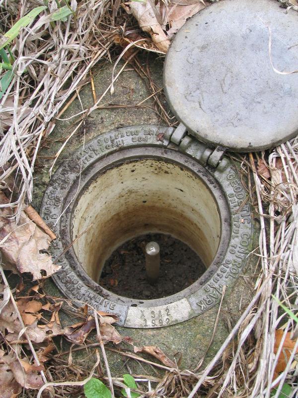
Although they are apparently real stable surveying-wise, I find them rather unappealing as targets - rather like rivets - unless they're needed for poker fun runs, in which case they're really cool. They may also be a ploy by creationists to prove that with evolution things don't necessarily get better.
-
Not everyone can finish a county, and there is no need to set a goal like that if it is not doable.
That is a cool idea, though - certainly worth bragging rights here.
I've not introduced my wife to rivet hunting - she thinks disks are boring enough....
-
Now I know I've been following a tapeworm.
Don't tell your friends!
He must be a little more brave than I am about heading along railroad tracks too, since that pesky B 95 I really wanted didn't look like I could get anywhere near it via road, and was quite a ways down the tracks.Oh, pshaw. Someone built a nice two-track access road along the tracks - just for benchmark hunters, I presume - that allows one to drive to a few hundred yards from the mark. Could drive all the way with the Jeep my wife wouldn't let me buy, rather than the sedan we purchased....
-
... plus 25 pts. bonus for completing all hands.
You the man!
-
(CONTRARY TO THE 2006 RECOVERY).
That's harsh.
Bet you know how to spell infirmary, though. Maybe even knew how to spell it in 1958.
-
There's really nothing that can be said to not harm the environment, except perhaps taking a digital picture of it.
I dunno - there's only so many pixels around, and once they're all used up....


Poker Fun Run
in Benchmarking
Posted
Muchas gracias!
And all the winners are to be inducted into the PFR Hall of Fame!!! I'm preparing my speech!!!