

sixthings
-
Posts
62 -
Joined
-
Last visited
Everything posted by sixthings
-
Did I do the right thing to log these as finds?
sixthings replied to cloversmom's topic in Benchmarking
Got it. Thanks -
Did I do the right thing to log these as finds?
sixthings replied to cloversmom's topic in Benchmarking
How about if the designation was stamped on the cover? I recall a thread (from several years ago) where most agreed that a metal cover or logo cap with the designation stamped on it did not require an opening and internal examination to constitute a righteous find. Is my recollection correct? 6 -
This from "seventhings" (who cannot access these fora): "Recovery of FQ0712 based on two factors: 1. The tower at FQ0712 and the tower referred to at FQ0713 were two different towers (see difference in adjusted coordinates) 2. The position of the tower at FQ0712 was confirmed (within the capabilities of a handheld GPS) with several GOTO fixes from positions along at least two-thirds of the arc of a circle around the tower, and at distances ranging from 30 feet to 200 feet. (The GPS GOTO pointed to the center of the tower continuously for about 15 minutes). If FQ0712 is NOT the tower observed (in whatever year), then it is a tower that occupies the same spot as the tower first observed, within a foot or so. In this case, my "FOUND" will stand, although I'm perfectly willing to qualify my post with a "Caution ...... " if it can be demonstarted that this is not the tower observed. BDT's supposition, above, is consistent with my thinking on the subject. I think that the tower that stands at this spot is the tower PID = FQ0712." Regards to all; six (for seven)
-
And the problem is ....... ?
-
There are gozillions (well, dozens) of DOI-NPS disk in Wash DC and in VA and MD along the Potomac in the National Parks upsteam of Wash DC, and 99.99% of those disks are NOT in either the Geocaching or NGS databases. See, for example: USDI-NPS waymark
-
In another thread I think seventhings advised the forum that the plan for the "special day" was abandoned for two reasons: Some other benchmark hunters worked the area a few weeks before he planned to get there, and scheduling developments did not allow as much time as initially planned. As it was, on 05/23/06, seventhings recorded 28 finds (22 FTFs), eight not found, and two noted as inaccessible. Not a bad day, but not his best (and not nearly as good as hoped). 6 p.s. - I'm relaying for seventhings because he no longer has access to this forum. It's a technical mystery to all involved. 6
-
To whom it may concern: The Lewis and Clark Commemorative disk at Giant Springs State Park, Great Falls, MT, is in the NGS database at PID = DI0232. DI0232 The commemorative disk at Traveler's Rest State Park, Lolo, MT, is in the NGS database at PID = DH9363. DH9363 Those Montana guys got their stuff together. 6 (for 7)
-
Sometimes reference marks (RMs) and azimuth marks (AZs) have their own PIDs and datasheets. In these cases, you definitely want to try to find them and log them. Usually, however, the RMs and AZs do not have PIDs. You can still log ("Found it", "Didn't find it", etc.) the station with the PID without finding/ photographing/describing the RMs and or AZ. However, most experienced benchmark hunters enjoy making the extra effort to search for and describe the RMs and AZ when a station has them. A typical post for such a station might look like this: "Found the station, as described. Found RM1 76.5 feet north (004 degrees true) of the station as described in the NGS datasheet. Searched for but did not find RM2. Found the AZ 0.3 miles northeast of the station, as described, and at handheld coordinates Nxx-xx.xxx W0xx-xx.xxx." 6
-
As “holograph” mentioned above, the two oldest benchmarks are JU3849 and JU3851, both gneiss Arc Line stones set by Charles Mason and Jeremiah Dixon in 1765. Both have an NGS monumentation date of 1765. However, Mason and Dixon’s survey set many (maybe, all) of the 84 Mason-Dixon limestone stones along the Tangent Line (western boundary of Delaware south of the Arc Line just south of Newark) in late 1764 and early 1765. Most of these stone still exist and have PIDs, although most were officially monumented between 1961 – 1982. During the 1751-1754 survey of the Transpeninsular Line (southern boundary of Delaware), colonial surveyors set eight gneiss boundary stones. The eastern-most is at 0 miles, and is located at the Fenwick Island lighthouse. The stone supports a disk that is HU1443. The stone at Mile 5 has its own PID, HU1546. The stone at Mile 10 stands on the southern edge of Selbyville, MD, and supports station NORMAN, PID = HU1543. The Mile 15 stone is lost, and has no PID. The Mile 20 stone stands in the graveyard at Line Methodist Church and is PID = HU1686. The Mile 25 stone exists, but it has been moved and now stands alongside the Mile 35 stone; its PID = HU1741 but, technically, it is “DESTROYED”. The Mile 30 stone is lost, and has no PID. The Mile 35 stone exists but it has no PID. It stands in an enclosure with the Mason-Dixon double crown stone at PID = HU1800 and the “destroyed” Mile 25 stone. The three Transpeninsular Stones (HU1546, HU1686 and HU1741) that have PIDs as stones (rather than as things that support disks with PIDs) were set in 1751-1755 but not “monumented” until 1974. See: HU1443 HU1546 HU1543 HU1686 HU1741, AND, HU1800
-
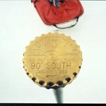
mine, although not NGS, is the one photographed in my avatar. the 90 degree South marker at the South Pole station. photographed in Jan99
-
and can you believe that he was going to take it easy for the next few months? when he told me he was going to lay off, i didn't believe him.
-
so...how bout that "ADAIR" station? there are some marks i simply can't get to.
-
the other thing to consider is that the benchmarks are a useful tool, and assist in the progress of many civil endeavors. this includes widening roads, and creating new ones also. it's illegal to destroy a benchmark through willful negligence or malice, but i really don't think it's illegal to pave one over in the name of progress. after all, that's what RESET benchmarks are for. if the benchmark is especially old, or interesting in some other way than being a bronze disk, then it may be worthwhile to try to save it. However, if there's a $200 fine for destroying the benchmark (which likely won't be collected) and the developer faces $2000 to re-route a driveway, you can be sure which option he'll choose.
-
you found reference mark for SU0958. you didn't find SU0958 itself, but you were close. if you read the datasheet, you'll find out where the station and the other reference marks are.
-
i have 2 marks that i have reported as destroyed. one was on the wall of a bank that got torn down in '34. on the other one, the concrete monument that housed the mark is broken to pieces, and is really not usable to anybody anymore. i don't think i will ever report anything as destroyed to the NGS; i just dont consider myself qualified, as this is just a hobby to me. the only way i would consider it is if it were a large structure that could be historically documented as gone. regarding TU014, i would log it as Not Found. your coordinates are adjusted, so i am sure you are in the right place. however, even with a clear sky and a WAAS GPSr, you have a 10' radius to deal with. it's possible that it's been covered in mulch, sod, or asphalt, like kk2111.
-
i hate to burst your bubble, but it appears as though you have not found ME1846. perhaps there was no PID assigned to the RESET; sometimes it happens. solicit opinions about the US Power Squadron, and you'll find it no surprise that they lgged it as "found". check out RX0680 for a good explanation by CallawayMT, a professional surveyor. check out alsoKK0564 and KK1344. this is a case in which a RESET was established in anticipation of the original getting destroyed by some planned renovatons. the irony is that the original survived the renovation, and evidently the RESET was in harm's way. it's possible that the RESET exists under the ground somewhere, therefore it's "Not Found", and not "Destroyed". [This message was edited by sixthings on August 09, 2003 at 03:10 PM.]
-
Looking for a bike..suggestions?
sixthings replied to donbadabon's topic in General geocaching topics
i have to echo Mr. Big's sentiments here. Aluminum frames are appropriate for some riders. steel is a preferred by others. it's impossible to apply the blanket statment "aluminum is better" to everyone. weight? some of the steel frames i have made are as light as high end aluminum frames. I know of a very good service-oriented shop in your area called Spokes, Etc. it's been a long time since i was in there, but several years ago if you bought a bike from them, the labor to adjust/ fix your bike was free forever. and the bikes didn't cost more because of it. they carried a good selection, too. -
come visit me.
-
Looking for a bike..suggestions?
sixthings replied to donbadabon's topic in General geocaching topics
Hey Donbadabon. I am an accomplished cyclist, formerly competitive, have worked in the cycling industry extensively, and i have made about a dozen bicycle frames myself. that said, there is a bike on the market called the Surly Cross Check. it's a decent Tig welded steel frame, with a decent selection of components on it. it can accomodate racks and fenders if you want them. it's quite comfortable, and can be ridden very well on-road and decently off-road. i'd stick to fire roads and somewhat groomed trails, as it wasn't really intended for hard-core mountain biking. i think it retails for 850. I have 0 affiliation with Surly, other than being a fan of their product. -
funny you mention JK1230, Papa. i noticed the mistake, and was going to check out the area next week to see if the actual station was still around. i logged a find on JK1235 with the same error. of course, i first found the RM a long time ago, and photograhed it out of pure curiousity, without knowing any better. i returned to JK1235 just a few weeks ago, hoping to find the station, but it's gone, i fear. i'll update and correct that log right now.
-
i hunt benchmarks only, so maybe something i want wont be appicable to geocachers. maybe it will. when i look at another hunter's stats, i would like to see a count of everything, not just the founds. even how many marks they have posted notes on, and reported destroyed. it would be like a baseball player's stats on the back of the card. the more data available, the more meaningful the ratios become. i would also like a way to sort the way i view my own cache page, and the way i view others' stats. for instance, when i view my own cache page, my marks are listed in reverse chronological order. when i view another's stats, their marks are listed alphabetically by PID. i would like to see others' marks in reverse chronological order, so i can see how busy they've been lately, and specifically where they've been. i don't want to scroll through Me and Bucky's 600 benchmark finds to see which is the most recent. anyone else with me?
-
i've used my tripod to reach a place i couldn't see, but i was in the middle of nowhere, not near a bridge, dam or resevoir. and my harebrained periscope idea would look even worse than that. DONT go look for it in the dead of night. Follow the advice of Artman and BDT; make a connection that can get you legal access, or just move on. check out JU3851. seventhings had to work the phones to get permission to hunt for this mark, and had a security officer at his side the whole time he was on the property.
-
Hey Papa, check out JK0843 for photos of a mark with nearby witness post. the good thing about this mark is that it is in your area. check out the area and see how easy it is to find the mark when you know this witness post is there to help.
-
i would use "post a note" to describe to the geocaching crowd the circumstances of this mark. it's a tough one about reporting it, though. as you've discovered, the Power Squadron may have done much of their surveying without getting out of their boats. however, the possibility remains that the mark you see through the fence is not the mark you seek, and indeed was reported correctly as "not found". how far inside the fence is it? will a long camera lens or binoculars allow you to confirm the stamping? i considered making a periscope about 12 feet long to confirm the designation on a mark that is just out of reach behind barbed wire. i still might. whatever you do, you can't log a found until you read the disc.
-
yes, always always ALWAYS take your datasheet with you. there's nothing worse than hiking up a 10,000 foot mountain/ hill, making an easy find, and later realizing that the stamping on your mark doesn't match. even worse, is that when you read the description, you realize that you were probably standing on the correct mark while photographing the wrong one. like this one.