


ZoomZoom
-
Posts
287 -
Joined
-
Last visited
Posts posted by ZoomZoom
-
-
Where are all my post or why can I not find some older posting? Was looking for my cougar picture but no...........
-
Some of these caches are no longer accessible, ask me, I know. Some are now in places you are no longer welcome to be unless you want a fine of some sort. You all go ahead and adopt, and adopt, and adopt...but don't dare ask me about one cache. I haven't done them all but I hardly have any more to tackle but I know problems with many...such as missing steps. Sorry I don't carry that info any longer but I know.
-
Well so be it, nice to see most will survive. Sorry for flipping out.
-
You mods better think twice about this. I have given an option to accept all but yet you make it difficult. please let's not draG THIS FURTHER THEN NEED BE. I asked politely to have these given to me...if anybody deserves these...I am the one.
-
and of course you don't bend the rules to your quidelines...I am awaiting an answer from the Team. This has been so suddenly.
-
Maybe...just maybe I want the world see how this goes...Email is for secrets
-
WiZ...stop it...you not listening to me...I will adopt all...that is not against the quidelines of yours.
I think it might be best to do this by email instead of a one sided forum thread. Also, it is not up to geocaching.com or the volunteer reviewer concerning the adoption of caches, that would be up to the cache owner. Since the caches here have been archived, it might be best to submit new listings after the cache has been checked up on and refreshed.
K whatever must be done but I want to make sure |I can adopt...is that still possible?
Wait a minute...just reread what you said and ur saying not possible?
Speak english and i am sure the Team will let me be
-
WiZ...stop it...you not listening to me...I will adopt all...that is not against the quidelines of yours.
-
I am asking you all at geocaching.com if you have a heart...please let me adopt them all. Working on getting volunteers to join me at saving these historical caches
-
Thank you Wiz for attempting to do something good about these caches. I am willing to adopt everyone of them though it will take me time to maintain them. Also hope you will accept my apology for earlier on but it really, really did upset me to see the Teams caches archived just all of a sudden. Sorry.
-
Low live scum bags
After seeing all this it really doesn't matter if you ban me cause I quit anyway...numbers never =mattered to me in the first place. ur not getting My support ever again
-
I live in the area but will not support this petition...sorry.
I also never will support that group responsible for closing off Harbourview who called themselves the TLC.
I haven't set foot back there since the take over but use to go there often. Access should be allowed for all. Just cause you and others can hike doesn't mean everybody can or wants too.
Before the TLC, there were real trails there but after the take over, they change the main trail into a road. There was one area you needed a 4X4 or walk to climb over the bedrock and I hear they built cabins up there also. God knows what else they have changed up there. 4-wheelers use to get together to do major clean ups up there every year and I mean garbage bins full. What did it get them?
Now they (TLC) are looking at grabbing more land for themselves again further down the island...bull crap.
-
I look at this and don't see how as you need an email address.
-
I recently bought the 450 and really like it. I decided on this one after using Magellans for as long as I remember but wanted to go paperless and the 450 was getting good reviews.
First thing you want to do is put on a screen protector when you get it.
-
I am just wondering how this got approved in the first place???
-
Read the guidelines people and I quote,
Caches near, on or under public structures deemed potential or possible targets for terrorist attacks. These may include but are not limited to highway bridges, dams, government buildings, elementary and secondary schools, and airports. -
In my youth I've done worst then that but learned after getting a good scare from the local law, at that time, that that was a no no. I was very young at the time.
Good to hear and read about this and know...some people are actually human still.
Hopefully she'll take up caching now instead of scavenger hunting.
-
Too bad they don't provide the coords to go check it out.

-
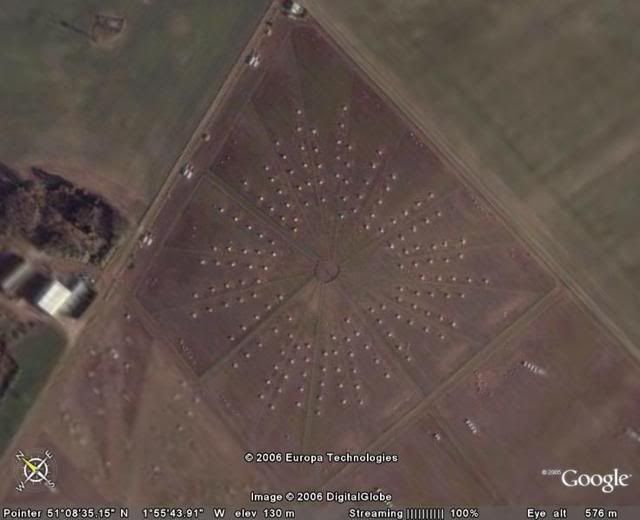
Been trying to keep this thread alive cause there's lot's of neat things to see via google earth, whish there were more clearafied areas such as Easter Island for example...wonder if we could see the big heads.
Hey isn't this Wilson from Tom Hanks moivie Cast Away???

-
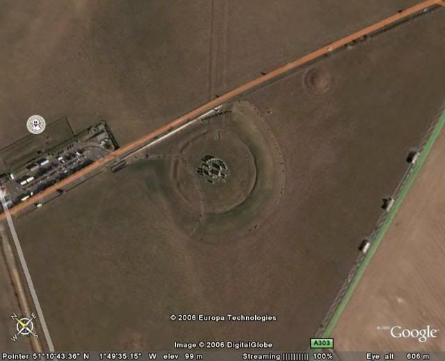
This looks cool, not sure what I'm looking at though.
Then here's Stonehenge.
-
I have a question.
How does our troops find support...let me revase this...even know that 250 or however million times a coinor whatever was made to support them?
Like I said...lot's I don't understand yet.
-
I was just voiceing my impression of the whole situation, more or less and am not lookig for a debate of any kind,...but since we are on the subject...I still don't understand why the church is involved in it either.
Clear to clear that up for me too?
-
I have lat and long of my position and lat and long of target. Using Excel, I want to calculate direction and distance to target. I know there are web pages that do it for you. I don't need this to be extremely accurate. I am willing to use, for example, where I am that one degree of lat is 69 miles and one degree of long is 52 miles. I can subract point two from pointt one and calculate the hypotenus to calculate distance. The direction is trickier. Four "if/then" statements depeding on which quadrent the target is in? Has any done this? Share the formula?
Do you want flat world or round world?

-

Did I die or something
in Canada
Posted
Don't friggen matter how long it's been...I should be able to see everyone of my posting here. MY POSTING>