


CTYankee9
-
Posts
307 -
Joined
-
Last visited
Posts posted by CTYankee9
-
-
That may well be, but it's of some interest that their maps still retain the exact errors from the TeleAtlas map set of North America that were in play when the copyright notice changed. In fact, as far as I can tell, nothing has changed at all apart from the copyright notice.Google have confirmed they have stopped using TeleAtlas as the map data provider for Google Maps in the US.
If you look at US Google Map data you will note the absence of the TeleAtlas Copyright message at the bottom of the page.
Perhaps what Google means to say, but hedged a bit, was that they would manage future updates to their maps on their own, but would use their licensed TeleAtlas database as their starting point?
Ditto for TeleAtlas and Navteq (source for Garmin's set), although it took them ages to actually incorporate requested changes.In the same way as MapShare, Google now allow you to report map errors directly to them.I have still have the TeleAtlas tag, it would appear that it depends on what you are looking at and how far out you are zoomed. If you only have the U.S. within the view, then no TeleAtlas. The mapsets change depending on where you are, for instance Kansas as you get in closer start using something from the USDA Farm Service Agency.
Side note: Just noticed that as you zoom into the ocean and once it fully loads the waves are animated! Pretty cool.
-
Yes; basically a normal beginning, middle, and sometimes end!
You will find other threads with lots of wisdom for the beginning cacher in this getting started forum from those with experience. Thing is look back on those 6 attempts/finds that you did with your family, any memories? Now that the "hard" part is over can you maybe say those hunts were actually fun?
See MM already got to it
 Pay very close attention to #7.
 -
he looks like he just had a meat too
It would seem like we have discovered where all the Hamsters in caches have been disapearing to!
-
We crossed paths with two Southern Pacific Rattlers while hunting for This cache. The second rattlesnake gave me one of the strongest adrenaline rushes i've ever had.
Always fun to become one {or two
 } with nature!
 -
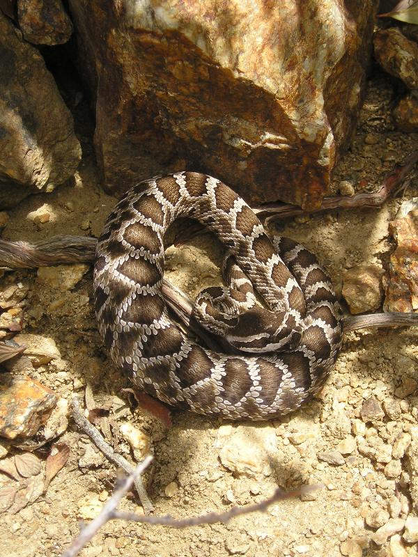
The cache was sitting right above this guy in the rocks. Read why it wasn't such a great concern:
-
Think it is a great idea, I wouldn't mind finding one in a cache. But, like others have said, make it even more interesting by personalizing it in some way and also protecting it from the possible rough handling that sometimes does occurr with cache containers. Much like the message in a bottle set adrift!
-
The thing I hate about homemade chips is that they don't hold up to moisture.
I also make these for myself and sometimes others and I have gone back and found some of the chips 2 years later in caches and they look fine. It all depends on the labels you use as well as the type of printer you have. Quality water resistant vinyl labels and photo-permanent inks in your printer and they can be expected to last quite some time. Yes even in one of my rarely found caches that was located on a saltwater delta area where the ammo can had all but rusted through {replaced with an all plastic container} and is submerged during each high tide.
Also the addition of an inexpensive 2x2 baggie makes them just a bit more resistant to the elements. About the only thing they don't hold up to is fire:
-
What does Muggle mean - anyone have a Geocache dictionary? Still trying to decode all the language.

-
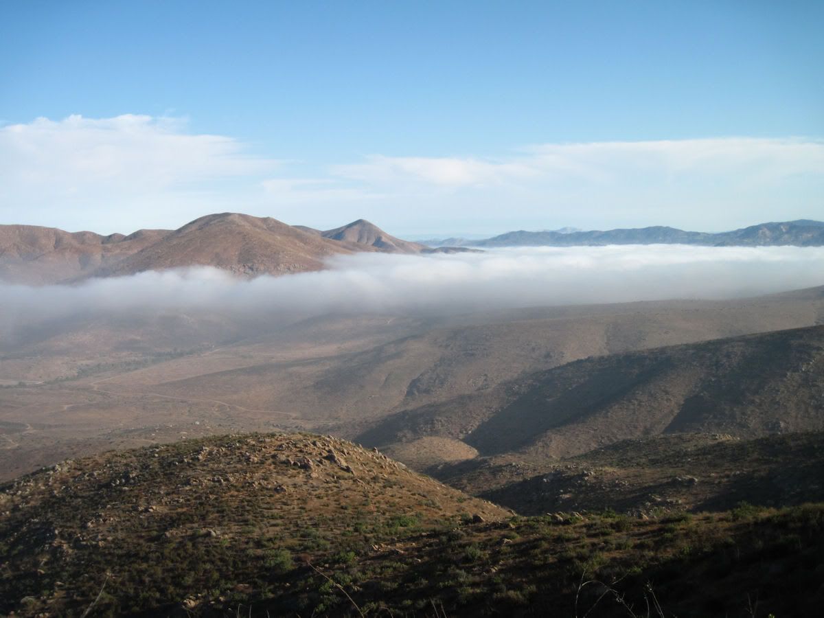
View from Dragon Ridge. Sad news is that this view is only part way
to the final hides. Trailhead is in this view, at the end of a dark line
of trees that leads to it from the right-flank of the central peak.
Another interesting view from up yonder under slightly different weather conditions.
-
Nevermind, I was woozy from the decent down and trying to post from my Blackberry wasn't working! And no I didn't bring my cache-mobile, just my old beater car, wouldn't want anything nice stolen out here. Ohh and Harmon, I made it alive; so please call off the tow-truck and enjoy your next trip out here!
OK, going to get some grub in my belly, burnt a lot of calories up there lugging stuff around for the Lemurians. But, after long discussions with them and learning some of their history, I will have to forward that info to MR in some manner. Hopefully he will find it interesting and pass that on to all of you!
-
Well, by now CTYankee9 will be trudging up Dragon Ridge and soon
heading down into the dreaded Lemurian Ravine of Sorrow. So here
is how it is ... I get first-dibs on his vehicle that's surely parked at
the traihead road gate.
Yes, I know, he feels safe because he's been battling Naga Guards
of late but let's face it, Lemurians eat Nagahide for breakfast.
I'll wait until tomorrow morning before sending a tow-truck out to haul
his ratty old truck in. Too bad he didn't undertake this misadventure
before the cash-for-clunkers program expired.
Yes, Harmon at this very moment sitting at your cache taking a break. Now just how mean are these Nagas?
You have left me nowhere to go, but UP!!!
-
Them Lemurians are eight feet tall ... he's a goner for sure.
When he's gone maybe we'll do an Yrium card for him.
Hmmmmm...
Considering over the past year or so during my absence I have done many a battle with their Naga guards, it would seem the prudent thing to do would be to leave some form of offering to appease them. If I can find the subterrrainian entrance to their sunken world, I will ask the local Atlanteans, I may just have to mark it as a warning to others!

Preparing to defend myself from the local Otay Naga.

His demise is near.
-
If anyone is interested, I am going to hike from GC1PG1K to GC1TKV2, on Monday the 28th of September. Start time will be about 6AM and can meet down near starting cache. Looks to be about a 7 mile'ish hike with a bit of elevation gain of about 2000 feet by reading past logs and looking at the maps. Not a killer hike, but a slow and steady one, get done when we get done and enjoy the ride.
-
Good thoughts folks.
I don't think 6 caches is over saturation. There aren't too close to each other. Give that if you parked anywere in skippack you could walk to those caches and enjoy your day. I know some parks I've looked at going to that have way more then that in a smaller total area.
So how do you go about finding who the local reviewer in the area is?
See who has been reviewing all the caches in your area and publishing them. Normally one screen name for any local area, maybe 2 at most.
-
It will depend on your local reveiwer{s}, your best bet is to discuss it with those that are actually going to approve your cache in question or the placement of a future cache. And this is best done before cache placement, give your reviewer a chance to mull it over and give the area a look; to see if there are any extenuating circumstances, before the cache is placed. It is a guidline, I am sure, and cache by cache considerations by your reviewer can be taken into account.
-
I notice in my area of the country especially in the more tourist type place cache swag is not traded according to the rules. The rule is that if you take something from a cache you put something of equal value or of greater value in the cache. I had a new unopened hotweels car in a cache. about $1.00 retail value. I was expecting that if someone chose to trade they would know it was worth about a dollar. The person traded but they left a quarter. WHAT AN INSULT! Why not just steal it? Basically they did. In whose warped world can you go and buy anything let alone a Hotwheels car for a quarter? It is getting bad. Some caches start out with some cool stuff. As time goes by it is all a bunch of junk. This really discourages me from starting out another geocache with any decent swag.
Matt-
I know you say you are not going to visit this thread again, but be honest; you will look in now and again. Because, it is your thread and you have an interest in it, much like your cache; but you have opened both up to the public by posting both the cache and this thread to GC.com.
Value of an item is subjective and resides with the person making the valuation. For instance, I like glow-n-dark stuff. I may come upon a cache that has what you value as a crap piece of stag, just a cheesy piece of plastic that happens to glow-n-dark. Yet I look at it and see the most wonderful thing in the world. Now what will I trade for it??? If the next cacher is in luck and I was travelling light with just my basic pack it will prolly be an unactivated geocoin. If it was a planned trip and I have my full pack with my normal trade items, then it may be just another piece of "junk" glow-n-dark plastic that I carry with me as one of my sig items. Such is life!
I guess the big picture here is you placed the cache and released it into the world for the public to visit, not all visitors are alike and not all will value your starting items the same. Trade-up or Trade-equal; great rule, although it again is based on the beholder of you swag's value. What he sees it's value as and what he perceives the value of the item in his hand is. Not all value is based on a monetary designation. You choose to let others come in and enjoy your cache and we all appreciate that, thank you for placing another that we may find.
The important thing here is that you gave the kid {if that is who made the trade} a few moments of enjoyment during the trade phase. Just think of the thoughts as he decided what would be a good exchange for that toy car he really likes. He made the decision that 25c was an equitable trade in his mind.
Side-note did you check that quarter? Possibly silver, possibly double-die...
-
If your are looking to get all 12K caches into your GPS, one of those custom POI loaders would be useful. I don't use them but have seen posts about them in the past and even tried it once, but I didn't find it necessary for my caching style. Don't know if all 12K will go in but you can get 1000s more caches in as POIs.
-
There is one GC1PMP5 in the San Diego area as well as others and hey look FTF is still open on it!

-
Anybody who hasn't done it interested in the Palomar Divide Truck Trail next week? Or any other not-too-tough four wheel drive routes? I am recovering from surgery and have a post-op shoe on my left foot. Would love to get someone wiith two good feet to cache with off road. I put the top and the doors back on the Jeep and even put the back seat in. It's supposed to be record heat but my AC works great.
I'll provide transportation but am seriously limited in bipedal mobility for a while. Would also welcome other vehicles for a cache run.
The one legged cacher for a while,
Barry
It doesn't have to be a 4WD route. I'll provide transportation for anyone wanting to do a day cache route who has two good feet...
What date/day of the week were you looking at? I might be interested if it is Monday the 21st {my day off}. Would be in my own truck, need to try it out again after some repairs/modifications; so that would be another seat for anyone that normally doesn't get a chance at the 4x4 cache trails. Also, it might be a good idea to move this over to San Diego Cache Events section?
-
Hey. thanks to all who have responded so far, including privately...looking forward to more. Some quick responses:
1. It is really me. See here, for example. But tozainamboku was cracking me up...I had read enough of that Ventura_Kids thread to get the joke.
2. Those links to Podcacher, Online Geocacher, and the Hunt / Unusual forums were very helpful. Checking them out now.
3. I visited the folks at Groundspeak a few months ago, and will probably look to do so again sometime soon now that I'm getting a little more hands-on caching experience.
Finally: the overlap between general geography fans and cachers is an interesting question. My guess is that the initial crop of diehard cachers (say, 5-8 years ago) WERE almost exclusively map/geography buffs of one kind or another. Who else owned a handheld GPS back then?
But as the sport grew, it accreted millions of fans who had no interest in geography at all: kids who liked Happy Meal toys, gadget geeks who just wanted to play with the cool new thing, outdoorsy types who liked the adventure, collector-mentality folks interesting in racking up big numbers of finds, etc.
But still, at the core of it, come on, it's a treasure hunt using geographic clues. With caching, the clues might be numerical coords instead of "100 paces west of the hangman's tree" or whatever, but it's still essentially treasure-map stuff straight out of Treasure Island. Which I imagine is a big central part of what turns people (especially kids) into geography nuts in the first place.
So I think there is still some kind of primal connection there. Am I crazy?
Far from being crazy...
I find it hard to belive that the majority of us just follow an arrow until the numbers count down to zero. Think of the planing that goes into a normal caching trip other than the spur of the moment hunts.
First you decide where and what type of caches you want to look for. You do this by using Google Earth or some other mapping program to see if you are capable of getting to those caches. You plug those caches into Mapsource or some other mapping program in order to get those caches into your GPS. You then use your mapping GPS with turn-by-turn directions on until you get near the 1st cache, then you switch over to the Topo maps to continue your trip. You then utilize those topo sheets to decide the best route to each cache with minimal elevation loss and shortest distance while staying on a trail. Yes, as you get close to the cache you then utilize the arrow to make life easier. Rinse and repeat if there is more than one cache location on your route for the day's fun.
This doesn't only apply to those remote caches but even to a day's jaunt through the city looking for urban micros. You are still using all these resources {Maps} for your days adventure.
Basically it is no different than my days in the Army back in the 80's. You are given a mission that includes some map coordinates, you plot those coordinates on your paper map using a protractor, you then decide the best route to those coordinates using some common sense and the map with a compass. Only difference now is that the topo maps fold a lot easier {push of a button and they are folded back into memory}. Instead of a co-driver looking at a paper map yelling out turn here or turn there, we get a friendly computer voice processing that map information telling us when to turn. Instead of a protractor and compass with have a neat compact GPS {still seem to misplace it just as much though}.
But, I have to agree I don't condsider myself a map/geography buff, nor was that the reason I got into geocaching. Having the background of being able to read a map and orientate myself to the terrain around me is just an added plus while outdoors enjoying what I enjoy. For those that have never had this experience and get into geocaching you can't help but think the geography doesn't rub-off onto them as they do it more and more?
Nor is the ultimate goal of the younger newer caches that I have cached with the Happy Meal toy. Yes that is the immediate gratification reward, but in the long run it seems the actual hunt in getting to that toy is of more importance. They get more enjoyment out of mastering a new skill {using the GPS and making the correct decisions in route planing} than in trading for that furry little bit of swag. So yes we are turning the younger generation into "Geography Nuts", even if they don't know it

-
ain't was commonly used in the 1600-1700's as a contraction of are not (am not) but it fell out of favor leading people to believe that it wasn't a proper word. It was and still is proper.
No it ain't!!!
Thank you, Donny Baker.

I was going to post that too! But alas it took so long to read through this thread just to get to a good punch-line {punchline}{punch line} I was beaten to it.
-
An event on the 31st October, off Highway 62 east of 29 Palms. There is a carp load of caches out there along the old mining roads that are a lot of fun to hit. I don't have the GC Code for it, or even remember the name of it. The Splashes and Habu were among the SD attendees at the last one out there. I don't know who is planning on going out this time, but I will if I have the Jeep back. Neither of our cars would handle the roads
-
I'm looking to get into geocaching, but I'm your typical broke student, so I'm looking at very low-end GPS sets. I was wondering if a few of you more experienced geocachers could tell me whether the model I'm considering would suffice?
and if that doesn't cut it, would this?
I would pass on the Bushnell one, doesn't look to be a geocaching GPS, but more of just a backtracking device for when you get lost.
The low-end Garmin is perfectly useable as a starter or even intermediate GPS for geocaching, you are looking for a way to get the cache locations into your GPS in an easy manner {ie... download to GPs device via USB or some sort of connecter from your computer}. I don't think the Bushnell one has that by looking at the add.
Or as was suggested the Geomate is designed as a starter unit, lots of caches built in, easy to use, but may be lacking if you don't like the type of caches pre-loaded into it.
And a last option is a mapping GPS unit {possibly used}, but only if you are unfamiliar with an area or do a lot of hiking possibly and need Topo style maps. These do start to get expensive though.
-
We are fairly new to geocaching and geocaching.com. I was hoping that someone could please tell me how to post pictures to our gallery on our profile? Any help would be greatly appreciated!
Thanks,
Heather
I don't think you can post directly to your gallery, if that is what you are asking. But, as you post pictures to the caches you find via the "upload a picture for this log" option, they will also go into your gallery.
 Pay very close attention to #7.

Using a 20 oz Coke bottle as a cache...
in General geocaching topics
Posted · Edited by CTYankee9
These are pretty cool! Softening temp of 158 degrees, would be great for stages of a multi even in the desert area. Heck, they even have a FTF safety seal, so you know for sure
CR- have you painted these with standard paints? Does it adhere well to the plastic?