


CTYankee9
-
Posts
307 -
Joined
-
Last visited
Posts posted by CTYankee9
-
-
Well, finally after about a year of trying to get my personal geocoin done, it has come to the final stage of sales!

There will be two versions available through a pre-sale handled by the manufacturer, it can be found at:
Also the individual coins:
Original artwork returned from the manufacturer:

A01 and A02 are the ones being offered on the pre-sales pages above. There will also be another two finishes that will be the LE and Artist versions only avaiable through me via trades. One will be the Antique Silver/Polished Gold metals with the A03 paint pattern for LE version. The Artist version will be Black Nickle/Polished gold with the A03 paint pattern. There will only be 150 LEs and 25-30 Artist's versions made.
Pictures of the coins available on the pre-sales page:


The coins are trackable and will have a unique icon. There is lettering around the edges that has the tracking code and some other stuff.
On the pre-sale page you can also read a little bit about the background of the coins faces and how I came up with them.
-
Sounds like a great idea, possibly not new, but still out of the ordinary. It is an event, so as long as the local reviewer where the main speaker is located and then each reviewer in the satallite locations doesn't see anything wrong with it, go for it! I do think that attendence at one of the locations would be the only way I would log is as "attended", not if I patched in from my home.
Think of the Mega-Event possibilities, would GS consider attendence in total of all the satallite locations????
-
So in all honesty the Ocotillo Event is a nice day in the desert
hunting temporary containers, a raffle, and the usual fun and
sociability of a desert gathering.
For me I was just trying to parse between the lines in order to
understand the game-plan. My guess is that the policy of "No
Geocaches allowed within park boundaries" still applies, yes?
Spoonfull of sugar makes the medicine go down.
It is what it is so have a great time all.
Unfortunately you are thinking of the neighboring State Park that yes, unfortunately, still has the no geocaching policy. The people from this State Park are making an attempt to embrace geocaching within their regulated bounderies by holding a geocaching event. My hopes are that their neighbors will see what potentionally is a boon to the park and reconsider their policies regarding geocaching.
Of note: No, I will not be logging 100 finds on the event page
. Can't say the same for Piglit, you know those dogs seem to have their own ethics! -
Good Morning!
We have now made the registration process a little clearer on one point. One GPSr per person will get you one registration packet per person. So if you have 4 GPSr's you wil have to have 4 (different) bodies attached to them. We are sorry if this dissapoints anyone but we want to try and keep it fair. If you have any extra GPSr's, invite your non-geocacher friends and show them how fun this sport can be!
We have also made the paper! The North County Times has run a story on the event. Please check it out here: http://www.nctimes.com/sports/columnists/c...html?mode=story
Sorry, I don't get it ... are the caches registered hides with a
Geocaching.com web page per cache or not? I note that this
question has been asked a couple of times before without being
answered.
Otherwise they aren't Geocaches, right? Nothing wrong with a
park-system day in the desert using GPS receivers but it surely
shouldn't be misrepresented. Geocaching.com finds or no finds?
So what's the deal, really?
Not trying to answer for Jeff, but reading the event page, the 100 caches placed for the weekend look to be "Event" style caches. Placed soley for the event's duration and then to be recovered afterwards. I would guess they are not being listed as official geocaches; so no, no smiley if all 100 are found {unless you log 100 finds on the event! :/}. Although he does infer that some of those 100 will be made permanent, but not all, so possibly those that go live can be logged as found once or if they do go live?
-
I will be heading up there early Friday leaving SD about 8 or 9ish AM, I need to get there to drop off some things to Jeff. My wife will not be going, but Piglit will, so I will have an extra seat in the truck if anyone needs a ride up or wants to jump in for caching. Also I will be staying until early Sunday morning, possibly won't be able to participate in the CITO that morning {need to be back in SD by 2PM}. So if you enjoy a leisurely caching pace and want the extra seat, drop me an email.
-
For those that may not frequent the geocoin discussion thread:

The two versions that will be available for the public {you guys} to purchase if you want sometime in February.
Also there will be 2 other versions made for myself for trading/leaving behind in caches, full story can be found in this thread:
-
"Luck of the Find" Geocoin update:
A couple samples were made this past week by the manufacturer and they look like...
Version #1 available for sale to the public. Polished Gold/Polished Silver metals the A01 ink pattern from above post.
Version #2 available for sale to the public. Polished Silver/Bronze metals with the A01 ink pattern from above {This one as far as metals may still be up in air}.
There will also be 2 other versions that I am purchasing for myself in an <LE style> Polished Gold/Antique Silver metals with the A03 ink pattern, no more than 125 made and an <Artist's version> done in Polished Gold/Black Nickel metals with the A03 ink pattern, no more than 25 made. These two versions will be the ones I use for trading and leaving behind in caches.
I think the 1st version hit the mark for what I was looking for from the original coin that the idea came from.
Pre-sale by the manufacturer is proposed for sometime in February possible mid, so this might make a nice St. Patrick's Day style coin {although it wasn't intended that way}. I will update once the sale date is definate.
If the Moderator could change the thread's title to:
Luck of the Find Geocoin
Samples made
I would appreciate it! Thank you!
-
If you meant for it to go into the Banter thread, you needed to hit the "add reply" not the "new topic" button while in the Banter thread.
-
What you need for true telecaching is a video link to the remote finder.
If this is possible, a live feed relatively cheap and portable, then the GPS is with the seeker, but only viewable by the coordinater at base. That way if the google maps aren't working out in the hunt then the guy at the base can follow the arrow! This would satisfy the needs a GPS to be real geocaching crowd.
On a side note: If we ain't geeks now, can you imagine the image of a feeding frenzy at a FTF of Telecachers!


-
Let's keep this on track please.
what!
it looks just like the outline of a kazoo!
Actually, our resident former MP/Ordnance expert noted in Post #30 that the kazoo denotes heavy weapons ammunition such as a .50 cal machine gun.
This would make for a good puzzle. Not having much luck finding NATO ammunition symbols on Google.
A couple spots that has some info, but not all encompassing.
Links and have to know what you are looking for.
Again I am not a puzzle kinda guy, but I guess the information can be obtained if someone wanted to develope a puzzle.
-
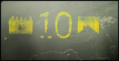
This is from a SoCal 30mm ammo can, but it appears to have the same markings as your photo. The second mark seems to match the M13 marking from flask's information. Side markings on the can were destroyed.
While not exactly what you are asking about, here are the lid markings from two 50mm cans.
Interesting. So these are on the top, not the side? I never noticed these symbols in 22 years in the Army, or as a Geocacher. But I was in a geek line of work even in the Army. Good thing there was an Ordnance man in the house (CTYankee).
The top one is also amunution stored in bandolier form/linked.
The middle one is just another symbol for bandolier form
And the bottom is heavy weapon amunition {ie a .50 cal M2 machine gun}.
Not ordinance but an MP for 15 years and it was mostly in Germany back in the NATO days. You get much higher than those markings and I won't be able to help.
To the OP, I think I see what your asking through the odd comments
. Yes you could probably use the markings to form a puzzle, but as has been said those markings should be removed from the cans so as not to cause alarm to the public. A possible way to do it is remove the original markings, paint/cammo your can as needed and then paint on the marking you need in a non-standard OD/yellow color. Or have the marking that is needed painted onto the inside of the lid for the finder.Each of the symbols relates to an actual word or abbreviated meaning, so I guess it could be done. I am not a puzzle kinda of cacher, so not sure how and no they are not only on the cans found from your home area, but are on all cans that have been marked for NATO use.
-
something like this?
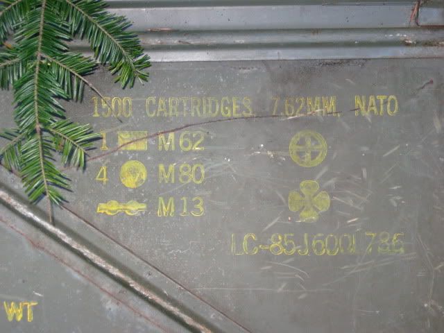
Yes, just like that, but without the numbers and text. Just symbols similar to those on the lid. The cans in my area must be the shorthand equivalent of that.
1 {Rectangle} = 1 tracer
4 {Circle} = 4 Ball ammunition ie regular bullet
{linked circles} = those rounds in a linked form
So those symbols equate to linked ammunition in a standard 4/1 ball/tracer.
{Circled Cross} = NATO Marked
{Clover} the ammunition is interchangeable with other weapons
On the Op's original picture that {V cut rectangle} meant the ammo was stored in bandoliers.
-
I LIKE IT!! It's so old school and fanciful at the same time. Like the Irish colours in the compass rose. I'm in for at least one. Good work!!
NB... please make sure the tracking numbers on the side are large enough to be legible - as is you can tell they're xxxx's but a B or an 8 or even a 5 and a 6 won't be so easily distinguishable.
I originally wanted the tracking number where the date is located, but was told it couldn't be done because of getting the hat buckle and clover to come out in the gold part of the finish. So I had to settle for the edge type. Really didn't want the geocoin to be too far off from the original hobo nickel, it is a great carving and didn't want to do it an injustice of changing too much on it.
-
Very nice!!
Are you talking about a reservation or a presale where we have to apy before the coins are in your hands? Having been burned with that type of presale I would have to wait and try to make a trade.
The presale will be handled by the company that is producing them. Once the samples are made and approved {metal finishes} they will let me know ahead of time and also they send out their presale notification for those that subscribe to it. I will post to this thread and have the title changed as I move through the minting process.
As I said version A01 will be available to anyone that wants to purchase from the minter and they may do another version on a different metal combination. Version A03 with the glitter will be "my" version and only available to me. Those I will use for trading and leaving behind in caches.
It is one of the larger minters and I have done business with them for a few years with no problems.
Not sure if I am allowed to type their name in here or not, I know I can't include a link to their general site, just to my coin's presale page when it comes time.
-
I like your coin! Perhaps you could include a picture of the original nickel that was your inspiration for the coin. You are lucky to have such a talented and generous friend to carve a coin for you. I don't think many of us could say we have that kind of coin in our collection. That's awesome.
I just have a comment: It might have been cool to have a Geocaching "G" inside the buckle on the hat or where the hand is placed on the back of the coin.
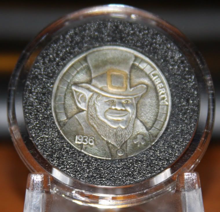
Original Coin that was made for me. Back is untouched Buffalo.
Yes I guess I should have possibly posted earlier in the process, looking at the die artwork one of the geocaching emblems would look nice inside the buckle. But hey we live and we learn, this is my firts attempt and I already have thoughts brewing for my next one. I will definately post earlier in here to get the thoughts from the regulars and those that have done this a bit.
The back with the flag of Ireland wouldn't be a go for the emblem. All those elements are integral to the the design and each has a meaning.
-
Like the backside.
Who is the guy on the front?
Not I
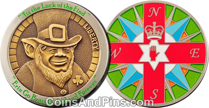
, just a carricture of an Elf that matches the Hobo Nickel that was carved for me as a gift. -
Hi All!
This coin is my first try at making one after a long time of collecting. It is currently at the stage of samples being made and will be available for "presale" sometime in the near future, unsure yet of what the cost is going to be though. There will be at least one version available {A01} and possibly a second {A02}, but not sure of the base metals for the second version. Then there is the third version that will be for myself {A03} to be made in a limited quantity for my personal use.
The coin is a "personal" one, but I think it isn't so specific to me that others might like to get one.
The design is based on a "hobo nickel" that was carved for me by a friend that I introduced to geocaching and the reverse is just a compass rose with the flag of Northern Ireland overlaid onto it, my ancestry.
As it goes through the process at the manufacturer, I will post updates in this thread and then when it is available I will then update again with the presales page once it is available for those that might be interested in one.
-
If anyone is interested I will be hiking up to Guatay Peak on Wed. the 11th of November. Looks to be about 6 miles RT with some elevation, not too tough. Start from trailhead about 6ish and a reasonable leisurly pace up and back. If needed we can carpool from the Rancho San Diego Steel Bridge near the intersection of the 94 and the 54, I have 3 seats in my truck.
-
--------<snip>------
But we see just the start of why this occurs. Too many possibilties in response entities, the difference in grid and spherical datums, and the sometimes necessity of using one or the other of those datums depending on what you do.
Ok, over-reaction on my part. I was just thinking about what might have happened without Minnie to guide the rescuers in...
Given what I know about navigation, grid/spherical datums, inter-agency coordination, etc. I really shouldn't shouldn't be surprised.
I've already known and accepted that I might not have cell coverage everywhere I am, that I might not have enough juice in my phone to make a call. That I might pass out before I am able to call.
I hadn't really thought about the fact that, even if I am able to successfully transmit my location to a 911 dispatcher, that this might not be adequate given the above complications.
I'd been considering a SPOT transmitter (given my penchant for solo hiking) but that won't solve the problems mentioned above...
Once again, a reminder that technology is not a panacea...
Over-reaction, not really; we as avid hikers would like for us to be found if we were to get in trouble. But, in reality the possibilty is there that as it stands it might not happen as quickly as would seem doable. Another good reason not to hike alone. Although I am guilty of this too, very rarely do I hike otherwise, other than Piglit along and she ain't no Lassie, so when I am in that proverbialy well, basically I am stuck there.
So it behooves those of us that enjoy the solo hiking to be aware of our surroundings and somewhat capable of assisting ourself in an emergency situation. Do you know your basic 1st aide, is your CPR certification current? Things like that. That is where people like Minnie come into play, not always your hiking partner, but maybe someone you happen upon. Would you know how to go about getting the proper response in this situation and provided the needed help as she did? I am not even sure I would, although all of my certifications are current. Until you are placed in a situation like this, who knows? Not preaching, just that something along this lines happened in my home with my Grandson a couple weeks ago. He began choking on a piece of food and my Daughter hasn't updated her certifications since highschool, simply dislodging the item was enough. But, if CPR was required, she wouldn't have known the up to date procedures, just the old way of thinking. Needless to say she is now enrolled in the 2 basic courses

Technology is great and I am sure it has saved more lives than it has endangered, but garbage in garbage out; best to know how it works and that knowledge needs to be second nature.
-
The helicopter EMT told me that they are always off the mark when given coords from hand-held GPS units. آ He thinks they use a different GPS protocol than we do.
Does anyone else find this statement appalling?
This could be a life or death thing and it's very unlikely that anyone who has a GPS receiver is going to be using anything other that WGS84. Unless some one read off the wrong coordinates, the search should start within 20 feet of the afflicted party.
Does someone have to die before they figure this out?
(BTW, very glad to hear that Mike was found and is doing better...we are always glad to see Mike and Minnie at the events and we'll be doubly glad to see them whenever we see them next.)
Best wishes to Mike on his recovery and also just as important my hat is off to Minnie on being able to properly assist Mike and then keep her cool in order to get the emergency response needed to her location.
As far as the response and the starting location by the air rescue unit we have to understand there are at least 8 different agencies operating in that area from federal all the way down to local emergency response teams. Yes it is a large problem in getting everybody on the same sheet of music as far as knowing what the location is that the caller is sending in that initial phone call. For variuos reasons the 3 different types of response units {air, water, land} use different datum and ways of navigating to that location. The various land units will almost always use WGS84 in some form, albiet just in different formats. The Border Patrol or most of the federal agancies will display theirs in decimal format, we as geocachers use our format, and someone else may use another. This shouldn't be a problem other than knowing what format was called in and being able to convert it to the responding unit's format. There is no difference in the physical location this way, just in the format viewed on the GPS.
The problem is normally at the air/sea level of response. They do not generally use this format due to the size of their area of responsibility. Also they will normally be given information and plot it on the map, then convert it to their on-board GPS. The problem arises out of how new or when their maps were updated, many of the maps still in use haven't been updated as there is no need. These remote areas do not change often enough to keep printed maps up to date. So there is the possibility the responding unit is using an old NAD27 map, this is what can cause an upward of 600 meters variance if not corrected in the conversion.
Is there a fix? Yes, but it is intensive. It starts with that 911 dispatcher and their training, they need to be aware of GPSs and how they are used and the differences between what they are hearing on the phone and what the response unit they are dispatching will need to understand. Is this easily accomplished? Not really, we have to think about that dispatcher. Generally there is a large turnover in that position, it is a demanding job and takes it toll on a person. So the training will have to be ongoing and continuous. Do all the 911 emergency responce consoles have this ability to adjust from what the data the dispatcher hears from the caller into what the responding unit needs, not likely. This would be cost intensive to have every dispatch center able to have this equipment and then again the training to operate it properly.
But we see just the start of why this occurs. Too many possibilties in response entities, the difference in grid and spherical datums, and the sometimes necessity of using one or the other of those datums depending on what you do.
All we can hope for is that there is a calm, collected, aware of their surroundings, and knowledgeable person on the ground at the scene able to compentantly work through all these problems. In effect a Minnie.
-
I was just wondering if anyone knows where to get decon containers in bulk that aren't 8 bucks each? Also, Bison tubes cheap?
http://store.colemans.com/cart/container-d...ml?currency=USD
If you noticed they are sold out. It would seem the military no longer issues these out and has stopped making them many years ago. So they are going to become harder and harder to find, if at all.
-
Great news but then who is not fine?My prayers are with you Jack. Like Harmon said, do what your doc says!
Sorry I misread the FisnJack message. Jack is fine.
It would seem Mike of mmcgr seems to have had a pretty hair raising emergency while caching down along the border.
-
Mine haven't changed. Live and let live as much as possible. I know where the line is and I have yet to seen it crossed with the scant amount of religious tracts I've come across. Maybe other areas are far worse than out here. My bet is that it is only one or two culprits are dropping them into caches in those areas. Remember that one bad apple doesn't spoil the bunch!Swimming against the tide and attempting to regain 'on topic' ground...I'd be interested to know if anyone's opinions on the subject of religious tracts in caches has changed from following this thread.
I know mine certainly haven't and won't, since I try to take a moderate approach to everything in life, I try to avoid excessive hyperbole and overreaction... however my opinion on some forum members has been changed... or rather it has been thoroughly enlightening for me to see where people position themselves.

I will say my views haven't changed any from reading this thread, nor would my views change from reading any sort of information gathered from a geocache. I have yet to run into one of these tracts in 1600+ caches, maybe I don't spend enough time sifting through the bits of paper, they could have been in there. I still believe they may be placed in the cache, just as they may be removed; like any other item found within the cache.
-
Would I care if someone placed those in caches, the answer is no. They have the right to free speech just as I do.
Isn't the cache private property though(bit of a gray area but still)?
Free speech does not exted to private property.
Since, when you place a geocache, you are still responsible for it, the argument would be made that the cache IS private property and that free speech does not extend to geocaches.
For those who WILL argue that Groundspeak would not have the right to limit the agenda of a geocache, they are correct, in a sense. While it could be argued that the term "geocache" is a broad term, geocaching.com (AKA Groundspeak) CAN regulate what they list on their site.
So, while you can have a geocache (using the broadened terminology) with an agenda, you are not guaranteed that geocaching.com will list the cache on their site. In fact, you aren't guaranteed anything.
Actually in a sense no, caches aren't private property. You have placed it in a public access area, published it on a public access web-site, and invited the general public to come and find it. You have also invited the public to access your cache as they see fit to trade from it. Even if you have placed your cache on private lands with the permission of the land's owner, you and the land's owner are still inviting the general public in to the lands that you have obtained permission to do so. You have accepted and agreed to the responsibilty of maintining this now public cache as public service.
On topic; The literature, icons, or whatever material you wish to leave behind relating to whatever belief you choose to represent in the cache are not prohibited by the broad brush of the guidelines. So may they be left behind? Sure. As someone who has been invited to come seek this cache, can I do as I please with the contents of the cache as long as I follow the spirit of the guidelines? Sure. If that means trading for one of your icons or tracts as I see fit, taking into account my valuation of that item then that is perfectly allowable.
Back off topic- Whoever that was that found the glow-n-dark Nun, get with me I am a collector of Glow-n-dark stuff from caches and my prior aquisitions need some fresh insight on their discussions.


Personal Geocoin now available
in West and Southwest
Posted
Hey all!
Finally my personal geocoin has become available for sales!
If you are interested and don't normally view the geocoin discussion forum the link to all the necessary infor mation can be found here:
Link to topic in Geocoin forum.