

happycycler
-
Posts
296 -
Joined
-
Last visited
Posts posted by happycycler
-
-
Yeah, Geocities don't want me to use them as a server. Thank you GeckoGeek for the insite! It is available on my GeoCities site though, if anyone wnted to go to all the trouble.... LOL

-
I will try to link in a photo of the 2000 Census Missouri Center of Population:

It obviously does not care to work for me -- maybe because I have a free GeoCities web site.
-
Thank you pnew for your kind comments. (I have occasionally posted less than good photos -- when my camera decides to focus on infinity instead of the disk that is 5 feet away or when I am moving the camera all around.)
-
time for a BUMP.
-
YAY!! for Buckey & Me!! And Artman, you are not doing so poorly yourself. Why don't some of you folks set still for a while and let me catch up!
I hope that someone lets us know when Bukey & Me breaks the 1 K barrior? -
Sometimes it is necessary to dig a bit, after a careful reading of the description on the datasheet. I sometimes use a metal probe to decide if and/or where to try a little dig. A good metal detector could also be helpful -- mine is not sensitive enough. You might enjoy reading the logs on the
JC0215 benchmark page. -
Dusty Jacket has at least one example of an azimuth mark disk on his very helpful web site: http://www.dustyjacket.com/benchmarks.html Please check there for examples of many of the physical objects that we search for.
The first azimuth mark that I found happened to have a PID of its own: KLEINSCHMIDT 2 AZ MK There is a photo of the disk in my log. More modern azimuth mark disk photos can be found at: PID=AA8564 Note the letter *A* in the designation -- for Azimuth mark.
-
Last weekend I thought that I had found JB1937
But I did notice the cornerstone and talked with someone at the church. Even though my Merigold did point to the current church spire, I can not be sure that it is in exactly the same place as the pre-tornado one.
-
I recently visitied the 2000 center of population marker for the state of Missouri (PID DE6442). It is nicely done in a roadside park -- for convience -- I understand that the true center is not easily reached. The marker is worth a stop and the hotel in Westphalia has a good family style meal on the weekends.

-
...continued... My keyboard stopped working. I was going to mention the photos of witness posts & benchmarks posts--but Dusty beat me to it.

Another thing, the benchmark GG0102 has SCALED coordinates. They were taken from a map and therefore may be off. I suggest that you depend more on the description than your GPS. I would start with:
quote:
...CEMENTED IN A DRILL HOLE IN A CURB AT THE EAST ENTRANCE TO THE PARK.Then (if necessary) measure your average pace and pace off the other distances that are mentioned in the description.
GOOD LUCK and welcome to benchmarking.
Everybody loves benchmarks more!
-
Great! Another person searching out benchmarks! Welcome to the fun. The object in your photo may be a highway RW (Right-of-Way) marker. I notice that Hwy 72 does run near GG0102 but I have personally not noticed highway RW markers in a city.
Everybody loves benchmarks more!
-
A positive comment for the Ram GPS Mounts. I bought one for my Magellan Merigold. I used it in the car (w/ suction cup) and on the bicycle for 8 - 9 months until it failed. I contacted the manufacture ( www.ram-mount.com
) and have received a replacement cradle. No cost to me except for some e-mailing back & forth.
So I have happy thoughts about Ram Mounts! Of course maybe their original design could be improved -- it did fail -- but I do take the GPS in & out of the cradle a bunch -- while caching and benchmarking.
Everybody loves benchmarks more!
-
Interesting that the adjusted coordinates are so different. EasyGPS says 334 feet between the two. From different eras with different accuracies?
Everybody loves benchmarks more!
-
I don't recall if there was a brown fence -- I have visited several benchmarks since then.
Unfortunately survey marks do get destroyed. But they also get overgrown by the grass or weeds, buried by mulch or scree and otherwise obscured.
In any case please go ahead and log a note for
AA8650 and include your find and photos of the azimuth mark (SL-129A).
Everybody loves benchmarks more!
-
Thanks all for your comments. The one on the St. Louis, MO end of the bridge is an easy find -- so ya all come on down.
Maybe someone with a good telephoto lens on a good camera could get a pix of the one on the Illinois end?Everybody loves benchmarks more!
-
As I recall, the disk is in the grass between the sidewalk and the curb.
quote:
Please take a look at the photos in my log. I believe that they were all taken from the position of SL-129.
THE STATION IS ON THE NW SIDE OF SPANISH POND ROAD, SOUTH OF JAMES PATRICK LANE.IT IS 27.4 FT (8.4 M) SOUTH OF THE CENTER LINE OF JAMES PATRICK LANE, 3.0 FT
(0.9 M) WEST OF THE END OF A CONCRETE APRON AT THE BACK OF CURB, 8.5 FT (2.6 M)
SW OF A STREET SIGN POST, 12.6 FT (3.8 M) WEST OF THE PAINT STRIPE AT THE EDGE
OF PAVEMENT, 19.4 FT (5.9 M) EAST OF THE CENTER OF A MANHOLE, 26.0 FT (7.9 M)
NORTH OF THE END POST OF A CHAIN LINK FENCE.
Everybody loves benchmarks more!
-
An interesting project! Wish that I lived nearer one of your *imaginary lines* of lat. or long.
But then I would need to build something! 
Will there be an on-line catalogue of your three exhibitions?
Everybody loves benchmarks more!
-
-
Thank you Survey Tech. It would be *cool* if these plates are unique to the Eads bridge.
The Eads bridge was dedicated July 4, 1874. Therefore it was in place before 1882 and is still the original bridge. It now carries a 2 way light rail line on the lower deck and the top deck was recently re-done for 2 lanes of automobile traffic with a ped/bike path on the South edge. (The upper deck was re-opened on July 4, 2003.)
Everybody loves benchmarks more!
-
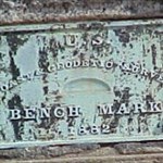
I am curious. Have others found any LARGE BRONZE PLATES (maybe about 6 by 10 inches) used as USC&GS benchmarks? There are 2 such plates PID=JC0043 and PID=JC0042
on the Eads Bridge in St. Louis. They carry a date of 1882. A pix of JC0043:
-
Yes 1 for 10 can be a good ratio. I have some streaks that where I had less finds per 10 searches. You can often increase your find ratio by looking for newer marks, those with ADJUSTED coordinates and of course those already found by another GeoCacher. But of course the older ones which have not been visited for a while can be more satisfying.
Whatever way you go -- keep on searching them out!
Everybody loves benchmarks more!
-
quote:
I would like to know if I might be able to log the finds that I get while at work. As it looks like I will be travelling I might be able to log finds fromeast coast to west coast and many points in between.I say GO FOR IT! I don't survey for a living but I appreciate all the GeoCaching benchmark logs. Please add yours!
Everybody loves benchmarks more!
-
Good job bradhig on finding the azimuth mark for AA8650. I hope that you go ahead and visit the AA8650 main survey mark (SL-129) and log both your azimuth mark (with photo) and main marks. You find & photo of the azimuth mark will
quote:
as RogBarn says. Or if you prefer to log a note on the AA8650 GeoCaching page (with your photo) about just the azimuth mark, that would be good also. I did not search for the azimuth mark when I did AA8650 -- I had not started looking for the azimuth marks at that time.
do the complete jobWelcome to the world of benchmark hunting!
Everybody loves benchmarks more!
-
You could go to thebenchmark page and enter the latitude and longitude. If you don't know those, then try entering the nearest ZIPCODE and select the likely marks. By using the MapQuest link or the TopoZone link you may be able to narrow it down?
Everybody loves benchmarks more!
I Found Another 100 Year-old Disk!
in Benchmarking
Posted
GOOD ONE bthomas!! Nicely documented and photographed also. Thank you for including the link for more info. Congrats!