

CallawayMT
-
Posts
379 -
Joined
-
Last visited
Everything posted by CallawayMT
-
George is looking for old USC&GS Brass disks. Geo, sorry but your two disks are from 1962 and 1970. CallawayMT
-
Another Historic Weekend plus a 4-Wheeler Ride
CallawayMT replied to CallawayMT's topic in Benchmarking
I did forget to put that in. Here it is now: 1904 USGS Bulletin on Primary Traverse and Triangulation Station VERONA CallawayMT -
Square Nail and I took another 500+ mile journey to see if we could un-bury some 100+ year old reference bottles. We had good luck once again and found 2 more bottles that were buried in 1904, as reference marks. We totally excavated the first bottle, photo'd and returned and then excavated the second bottle to the neck and then re-buried that bottle. Both were right on the azimuth and distance as described. Here is a link to station VERONA: VERONA And a few photos: BOTTLE 1 APPEARING THE 104 YEAR BOTTLE Just a few miles away we decided to try and get to Station CARP, which was also set in 1904 and was supposed to have 2 reference bottles as well. We stopped at a nearby ranch house to ask permission to get to CARP, which was 0.8 miles from the house and approximately 0.5 miles from the road across a wheat field. We explained that we just wanted to walk out to the brass cap mark out in his field and that it had been set about 104 years ago. He looked at us and said that it was too far to get to, but we could go to it IF we used his 4-wheeler and drove up to it. We claimed that we would be happy to walk to it, but he insisted that we drive through his wheat field to go see the mark. That was a new one on both of us, but we weren't about to argue with him and gladly hopped on and drove to the station within minutes. Unfortunately the station has been hit by farming over the years and the fields run right up to the station. We did do some digging for the bottles, but did not have any luck and did not want to do any further damage to the wheat. Since farming had hit the pipe and it was out of the ground quite a bit, it is possible that the bottles were tilled out long ago. This station was a little different in the fact that the cap was not stamped in 1904, like our previous recoveries, but the 1952 crew claims that they did recover and stamp this cap at that time. CARP We were happy to uncover two new 1904 pipe caps and two more 1904 bottles. With the price of gas, we will not be searching this area again any time soon. The offer to use a 4-wheeler was a big surprise and just goes to show you what some people are willing to let you do on their land. CallawayMT
-
CoyoteTrust, Nice photos, but near Chicago, Illinois, is the last place I would expect to see US Forest Service land surveys taking place. Is there really any Forest Service land in that area? CallawayMT
-
Patty, This page will help you out: Key to Topographic Maps and here is a good USGS .pdf document: USGS Topo Symbols Basically the dashed section lines generally are used in unsurveyed or protacted areas while the solid section lines are in areas which have been surveyed. The red tick or + marks are put on corners which were identified with some sort of found monument or sometimes a fence corner. I'm not sure on the T question. CallawayMT
-
Grav, You can check out this very informative article about the $250 fine, by Jerry Penry. $250 Fine CallawayMT
-
Bill, If you notice there was an era in the 50's & 60's where the disks had a hole drilled all the way through the disks. The USC&GS thought that this would act as an air release while seating the disk in concrete. They found out that the hole was not a good idea due to the fact that some thought this was the correct punch mark. I think that they also found that water got into some marks and the freeze-thaw action was not a good thing for geodetic disks. CallawayMT
-
Nice hike! Mine was this one: Lolo 9075 The hardest find I have ever accomplished! 12 hours of hiking, 14 miles, 3800 foot of elevation, no trail after the first 5.5 miles, a 100 year old section corner stone found, another corner searched for and not found, and two different peaks scaled. CallawayMT
-
Accuracy of locations for triangulation stations
CallawayMT replied to Papa-Bear-NYC's topic in Benchmarking
I wanted to make an update to my earlier posts. The following NGS recovery was submitted: This station falls on a high bluff of BLM land approximately 4.5 miles due north from the town of Big Sandy. From the town of Big Sandy travel northerly 2.5 miles along state highway 87 to a gravel road on the left, travel north on this gravel road for 4 miles, near a large gravel pit, turn left(west) and travel 1 mile to a 4-way intersection and turn left(south) for 1.4 miles and a wire gate on the left, go through the gate and up the west facing bluff for 1000 feet and the station at the top of the bluff. A standard 3 3/4" USGS brass cap on an iron pipe was found in good condition, protruding approximately 6" out of the ground with the remnants of a wood and wire target lying around the area. The following additional information was located and verified on this recovery: Original description transcribed from the United States Geological Survey Bulletin Number 276 entitled “Results of Primary Triangulation and Primary Traverse Fiscal Year 1904-5" by Samuel S. Gannett. On the east bank of Lonesome Lake Coulee, 6 miles southwest of Box Elder railroad station and 2 miles west of railroad track. Station mark: An iron bench-mark post set 40 inches in ground. Reference marks: Bottle 8 inches underground, true azimuth, 174 degree 40'; distant 5.8 feet from station; bottle 8 inches underground, true azimuth, 358 degree 16'; distant 5.7 feet from station. At 2 degree azimuth and 5.7 feet from the station, a Carter’s One Full Quart ink bottle was found approximately 20" below the ground surface. The bottle was standing upright and was in excellent condition. At 174 degree azimuth and 5.8 feet from the station, a clear one quart whiskey or beer bottle with a cork in it was found upright and approximately 10" below the ground surface. This bottle had a chip out of the lip, but was otherwise in excellent condition. Both bottles were removed for photos, but have been replaced in their original positions with ½"x18" rebar placed over and alongside the bottles for easier future recovery. Each reference location had a flat stone placed over the location originally and each stone was also replaced over the reference location. I did feel that this was the wrong thing to do and so the bottles were replaced in their original positions. Marked or un-marked, original un-disturbed evidence should be left as found. Kurt -
Astro, From your post, I could not tell whether you had a destroyed mark, or not. You say buried in a mound, well many of the marks are buried in a mound. You say that it is not where it is supposed to be, well many new benchmarkers(which you are not) say that a bench mark (scaled coordinates) is not where it is supposed to be. For these reasons, we surveyors and the NGS do not quickly accept what has been stated by some benchmarkers. I did look at your photos and it does appear that the bench mark is lying horizontally on its side, if you were to state that, I would know right off that the mark is destroyed. When you state that it is not where it belongs and you add that you were able to find good reference calls and that you pulled distances from those and the mark does not fit, and that the reference calls were in the position that they originally were, then I would have more confidence in your log. Good find, but it is destroyed, and the photos will get it taken out of the data base. CallawayMT
-
HMM now this one is 51 years older set in 1800 by USE. It was logged in the Bingo contest,now I am going to have to do some more research. AI4534 SP 3 There is a slew of other USE marks in the area and all of them were set in 1940. These disks are the same style as SP 3. Chances are that SP3 was also set in 1940, which make more sense given the disk type and setting. CallawayMT
-
Bill, I agree, a 60' half-width is a fairly common road width. The DOT's have been going back and forth between metric and US standard for quite some time. Most are back to the US standard again. Using both on a project is not a great idea, but sometimes they are monumenting an R/W on an old project basis using the current standard.
-
This may not necessarily be a corner, but simply a station and offset along the Utah R/W. The monument was set by: Detail for 368359-2201 Name RYAN BLAKE CHRISTENSEN City, State, Zip WEST HAVEN, UT 844016778 License Information: Profession ENGINEER/LAND SURVEYOR License Type PROFESSIONAL LAND SURVEYOR License Number 368359-2201 Obtained By UNKNOWN License Status ACTIVE Status Change Reason RENEWAL OF LICENSE Original Issue Date 04/17/2001 Expiration Date 03/31/2009 Disciplinary Action NONE Docket Number N/A As mentioned by BDT and Bill93 this has the LS for the Land Surveyor in charge 59.714 for 59.714 meters or feet left or right from Centerline 22,801.888 feet or meters from the start of the stationing 1763.57 meters for the elevation(from what you have said) and 2002 the year of the survey If the elevation is in meters, I would assume that all of the measurements would be in the metric system. CallawayMT
-
Accuracy of locations for triangulation stations
CallawayMT replied to Papa-Bear-NYC's topic in Benchmarking
Two questions:1) how close was the distance for Benton? (did you remeasure it after you dug it up?) 2) What type of compass was your friend using with the tripod? How accurate? Is this consumer grade or professional equipment - in other words could I afford one ? And I think it was fine to keep those bottles. Just leave that stone where it was! Thanks Richard aka Papa Bear Richard, Unfortunately, we did not remeasure after we found the sub-surface mark. I want to keep this a fun hobby for me and as such, I do not do as good of work as many of you at documenting these discoveries. It was within a degree for angle and my guess is that it was within a foot(probably a couple tenths) for distance. With these type of compasses on a tripod and a proper declination inserted, I would say they are accurate to within a degree maybe two. Absolutely a useful tool for these types of recoveries. Kurt As a sidenote, I was asked by Wintertime why I don't use my name in this forum, I have always just used the geocaching name that I had signed up for years ago and never really thought about it. I have had emails from more than a few people in this forum and have always used my name in those emails. If you want to know a little about me, you can go to this link Caching Now Story and see the article that Berntsen asked me to write a few months back. -
Accuracy of locations for triangulation stations
CallawayMT replied to Papa-Bear-NYC's topic in Benchmarking
Absolutely I would have done differently. If a bottle were the station, I would not disturb in the least, unless I am willing to take the time and effort to go throught the NGS blue-booking process, I would never disturb an un-disturbed station of any sort. I did not de-grade this station in any way, these were RM's and the station still has reference marks of a more findable and useable value. Thanks, Kurt -
Accuracy of locations for triangulation stations
CallawayMT replied to Papa-Bear-NYC's topic in Benchmarking
BDT, You are correct in what you say about geocachers and benchmarking and as John posts, I am a Professional Land Surveyor, Square Nail is not. For that reason I accept any responsibility as to our actions when we are together. These bottles have no monetary value what so ever to me, they only have historical value. Why did NGS choose not to include the RM's when they brought these marks into the data base? I do not know, I do know that this station, after I submit a recovery, will have an increased chance for recovery if it is lost. BUT it would never be recovered if lost for any survey efforts. It does have a historical value and yes, we did degrade that. Would anybody ever come looking again in the future? Who knows. As a surveyor I do not feel that we did anything improper, or obviously I would not go tooting my horn about it. As a historian I do feel that we should be putting the bottles back in place. Also as a surveyor I should be setting an example in this forum, if what I did causes somebody else to go out and dig up survey monuments or control, then I have performed a dis-service. This is why I opened myself up to scrutiny amongst those that frequent this forum. I feel that the majority of you who post here on a regular basis act very professionally in the recoveries and reports that you submit, I value your opinions and I feel the opinions of others sometimes helps us right our personal and ethical compasses. Thanks for your input, Kurt aka CallawayMT -
Accuracy of locations for triangulation stations
CallawayMT replied to Papa-Bear-NYC's topic in Benchmarking
I have been second guessing our acquisition and may still replace the bottles at some point in the future. I do give talks on survey history and thought that they may come in handy for a talk some day. I did not consider the taking of the bottles as any sort of degradation to the survey or monument or I would have never considered taking them. To put things into survey perspective; I have explained in the past that intersection stations have about a 0.05% chance for being used as a survey monument in this age of time. These old second and third order triangulation stations for all practicallity are also not very usable. They can be used for conventional stations to put a very low order geodetic or state plane value on nearby objects, but they will not be used for a GPS base station without putting an updated value on the position. If I were to set a GPS base on this station for instance and then send the GPS data into NGS for an OPUS position I would not expect it to be any closer than about 3 feet in value. That being said, I do use any and all existing survey monuments in a project area if it is convenient to use for a base station. You have a solid highly visible monument that is easy to describe and already has a data sheet assigned to it. These types of stations are my favorite to go find for their historical value and for the appreciation of the work that took place to monument and survey this mark. This station has not been changed and the RM bottles had been excluded by the USC&GS and NGS, but we were able to find them based on the station. If the surveyors had blown and angle by more than 10 degrees or a distance by more than a foot, we would have never found them. If this station were lost, the RM's would never be used to reestablish the station due to the low value that it holds. Does any of this make it right that we took the bottles? Maybe not. CallawayMT -
Accuracy of locations for triangulation stations
CallawayMT replied to Papa-Bear-NYC's topic in Benchmarking
Yes the rebar are where the bottles were and no I did not put my LS numbered cap on the rebar as it is not required or necessary in this case. I think this can or will make for an interesting conversation. Do you feel that we did wrong by taking the bottles? CallawayMT -
Accuracy of locations for triangulation stations
CallawayMT replied to Papa-Bear-NYC's topic in Benchmarking
I was going to mention that and did forget. We did keep these two bottles, but replaced them with rebar. The rebar are actually findable without finding the mark first and I will file a report with NGS. As you can see from the post, unless you had found the original USGS reports, you would never even know that the bottles existed. There would be no possible way of ever finding the bottles without knowing where the station existed. I do not abdicate plundering these old stations, but in my opinion we did leave it better than we found it and will not take any further bottles if and when we go see what was buried at the other approximate 15 stations in the report. CallawayMT -
Accuracy of locations for triangulation stations
CallawayMT replied to Papa-Bear-NYC's topic in Benchmarking
Pappa Bear, You spurred me into completing two recoveries that square nail and I completed 2 weeks ago, both are relevant to your questions. The attached USGS Triangulation book was found in 2007 and a return to this station was required to find the buried bottle RM's. NGS did not call out the bottle RM's and so we did not look for them in 2005, but we talked about going back there when the ground thawed out and seeing if we could find what they had buried. USGS Station Coulee On May 3, 2008 we decided to head out early for a short and quick 575 mile round trip journey to see if we could find these 104 year old bottles. We arrived at the mark at 9:45 in the morning and it was clear and warming to around 55 degrees. Square Nail set up his staff compass over the mark and turned in the 174 degree RM Azimuth and there was a flat stone on the surface at that point, I moved the stone and proceeded to gently dig in about a 2 foot radius. Square Nail then turned the 358 degree Azimuth and measured out to find another flat stone at that point. He took photos while I was digging. I was down at least 12 inches in the 2 foot radius; did they really bury a bottle, did they blow an angle or distance, why am I not hitting anything - the RM was to be buried 8 inches? I stopped and we went to the other RM position and started digging down, the digging was fairly easy with a sandy-silty soil. After about 10 or 15 minutes of digging I hit a shiny object and sure enough at about 10" below the surface the top of a bottle began to emerge. It had a cork in it and was buried stem upright, it appears to be a beer or whiskey bottle and is in good condition with an old chip out of the lip, but otherwise intact. There must me a bottle under that other rock, so back to work on the other RM, I expanded the hole and kept digging down. Finally I spotted some shine on the northwest edge of our hole and approximately 20" below the surface. A Carters Full Quart bottle in excellent condition appeared from the depths. It was more than twice as deep as called for and appeared to be approximately 5 degrees out in the Azimuth. In the area we also found a couple odd sized rim fire casings and an old rusted shovel head, the shovel probably being from the USGS crew. So first, they were called for buried 8" - we did not know if they were upright or upside-down, the bottom buried 8" with the tops protruding and probably broken. When we found them one at approximately 10" and the other 20" below the surface. Don't assume that they are as stated for depth. These both fit right on for the RM distances and the south RM was nearly perfect for angle, but the northerly RM was much deeper and approximately 5 degrees out. Remember that these were very short distances, so the angular calls were not that significant for the amount that they were off. We made another stop on our way home for one last look for an 1889 Missouri River Commission station that we had each separately and jointly searched for two times in the past 5 years. We had a new probe and decided that we could find the sub-surface mark. Missouri River Commission Station BENTON - 1889 SS1660 *********************************************************************** SS1660 DESIGNATION - BENTON SS1660 PID - SS1660 SS1660 STATE/COUNTY- MT/CHOUTEAU SS1660 USGS QUAD - FORT BENTON (1954) SS1660 SS1660 *CURRENT SURVEY CONTROL SS1660 ___________________________________________________________________ SS1660* NAD 83(1992)- 47 48 49.20167(N) 110 42 06.47935(W) ADJUSTED SS1660* NAVD 88 - 902.5 (meters) 2961. (feet) VERTCON SS1660 ___________________________________________________________________ SS1660 LAPLACE CORR- -0.50 (seconds) DEFLEC99 SS1660 GEOID HEIGHT- -14.69 (meters) GEOID99 SS1660 SS1660 HORZ ORDER - THIRD SS1660 SS1660.The horizontal coordinates were established by classical geodetic methods SS1660.and adjusted by the National Geodetic Survey in July 1992. SS1660 SS1660.The NAVD 88 height was computed by applying the VERTCON shift value to SS1660.the NGVD 29 height (displayed under SUPERSEDED SURVEY CONTROL.) SS1660 SS1660.The Laplace correction was computed from DEFLEC99 derived deflections. SS1660 SS1660.The geoid height was determined by GEOID99. SS1660 SS1660; North East Units Scale Converg. SS1660;SPC MT - 396,678.031 510,042.177 MT 0.99949051 -0 52 44.8 SS1660;UTM 12 - 5,295,633.484 522,324.366 MT 0.99960612 +0 13 15.4 SS1660 SS1660 SUPERSEDED SURVEY CONTROL SS1660 SS1660 NAD 83(1986)- 47 48 49.19803(N) 110 42 06.45806(W) AD( ) 3 SS1660 NGVD 29 - 901.7 (m) 2958. (f) VERT ANG SS1660 SS1660.Superseded values are not recommended for survey control. SS1660.NGS no longer adjusts projects to the NAD 27 or NGVD 29 datums. SS1660.See file dsdata.txt to determine how the superseded data were derived. SS1660 SS1660_MARKER: DS = TRIANGULATION STATION DISK SS1660_SETTING: 17 = SET INTO TOP OF METAL PIPE DRIVEN INTO GROUND SS1660_STABILITY: D = MARK OF QUESTIONABLE OR UNKNOWN STABILITY SS1660 SS1660 HISTORY - Date Condition Recov. By SS1660 HISTORY - 1889 MONUMENTED MORC SS1660 HISTORY - 1954 MARK NOT FOUND USGS SS1660 SS1660 STATION DESCRIPTION SS1660 SS1660''DESCRIBED BY US GEOLOGICAL SURVEY 1954 SS1660''FOLLOWING DESCRIPTION BY MORC SS1660'' SS1660''BENTON IS ON THE LEFT BANK, ON THE HIGHEST PART OF BENTON HILL, 2 MI. SS1660''W. FROM FORT BENTON, AND NEAR THE HELENA ROAD. SS1660'' SS1660''NOTE--REPORTED NOT FOUND BY USGS IN 1954. SS1660'' SS1660''STATION MARK--STANDARD MONUMENT WITH AN IRON PIPE AND CAP. As you can see USGS did not find it in 1954 and the USC&GS set a new station nearby in 1949 SS1568 *********************************************************************** SS1568 DESIGNATION - FORT BENTON SS1568 PID - SS1568 SS1568 STATE/COUNTY- MT/CHOUTEAU SS1568 USGS QUAD - FORT BENTON (1954) SS1568 SS1568 *CURRENT SURVEY CONTROL SS1568 ___________________________________________________________________ SS1568* NAD 83(1992)- 47 48 49.37880(N) 110 42 06.35948(W) ADJUSTED SS1568* NAVD 88 - 902.53 (+/-2cm) 2961.1 (feet) VERTCON SS1568 ___________________________________________________________________ SS1568 LAPLACE CORR- -0.50 (seconds) DEFLEC99 SS1568 GEOID HEIGHT- -14.69 (meters) GEOID99 SS1568 SS1568 HORZ ORDER - SECOND SS1568 VERT ORDER - THIRD ? (See Below) SS1568 SS1568.The horizontal coordinates were established by classical geodetic methods SS1568.and adjusted by the National Geodetic Survey in July 1992. SS1568 SS1568.The NAVD 88 height was computed by applying the VERTCON shift value to SS1568.the NGVD 29 height (displayed under SUPERSEDED SURVEY CONTROL.) SS1568.The vertical order pertains to the superseded datum. SS1568 SS1568.The Laplace correction was computed from DEFLEC99 derived deflections. SS1568 SS1568.The geoid height was determined by GEOID99. SS1568 SS1568; North East Units Scale Converg. SS1568;SPC MT - 396,683.460 510,044.753 MT 0.99949052 -0 52 44.8 SS1568;UTM 12 - 5,295,638.962 522,326.837 MT 0.99960613 +0 13 15.5 SS1568 SS1568: Primary Azimuth Mark Grid Az SS1568:SPC MT - FORT BENTON AZ MK 314 37 52.1 SS1568:UTM 12 - FORT BENTON AZ MK 313 31 51.8 SS1568 SS1568|---------------------------------------------------------------------| SS1568| PID Reference Object Distance Geod. Az | SS1568| dddmmss.s | SS1568| FORT BENTON RM 2 6.413 METERS 01106 | SS1568| SS1527 HIGHWOOD BALDY APPROX.41.7 KM 1723810.1 | SS1568| FORT BENTON RM 1 7.690 METERS 27507 | SS1568| FORT BENTON AZ MK 3134507.3 | SS1568|---------------------------------------------------------------------| SS1568 SS1568 SUPERSEDED SURVEY CONTROL SS1568 SS1568 NAD 83(1986)- 47 48 49.37514(N) 110 42 06.33809(W) AD( ) 2 SS1568 NAD 27 - 47 48 49.48600(N) 110 42 03.56100(W) AD( ) 2 SS1568 NGVD 29 - 901.68 (m) 2958.3 (f) LEVELING 3 SS1568 SS1568.Superseded values are not recommended for survey control. SS1568.NGS no longer adjusts projects to the NAD 27 or NGVD 29 datums. SS1568.See file dsdata.txt to determine how the superseded data were derived. SS1568 SS1568_MARKER: DS = TRIANGULATION STATION DISK SS1568_SETTING: 7 = SET IN TOP OF CONCRETE MONUMENT SS1568 SS1568 HISTORY - Date Condition Recov. By SS1568 HISTORY - 1949 MONUMENTED CGS SS1568 SS1568 STATION DESCRIPTION SS1568 SS1568''DESCRIBED BY COAST AND GEODETIC SURVEY 1949 (MJT) SS1568''STATION IS ABOUT 2 MILES WEST OF FORT BENTON, ON THE HIGHEST SS1568''POINT BETWEEN THE RIVER AND THE INTERSECTION OF U.S. HIGHWAY 87 SS1568''AND THE ROAD LEADING INTO FORT BENTON, ABOUT 300 YARDS NORTH SS1568''OF THE RIVER, 12 FEET NORTHWEST OF A WITNESS POST. SS1568'' SS1568''TO REACH FROM THE POST OFFICE IN FORT BENTON, GO NORTH FOR 0.3 SS1568''MILE TO A T-INTERSECTION, TURN LEFT AND GO WEST FOR 1.65 MILES SS1568''TO TOP OF HILL AND THE JUNCTION WITH U.S. HIGHWAY 87 AND A TRACK SS1568''ROAD ON THE LEFT, TURN LEFT ON TRACK ROAD FOR ABOUT 20 YARDS SS1568''TO THE AZIMUTH MARK ON THE RIGHT, CONTINUE SOUTH AND SOUTHEAST SS1568''FOR 0.35 MILE TO THE TOP OF THE HILL AND THE STATION. SS1568'' SS1568''REFERENCE MARK NO. 1 PROJECTS 4 INCHES AND THE DISK IS STAMPED SS1568''FORT BENTON NO 1 1949. SS1568'' SS1568''REFERENCE MARK NO. 2 PROJECTS 6 INCHES AND THE DISK IS STAMPED SS1568''FORT BENTON NO 2 1949. SS1568'' SS1568''AZIMUTH MARK IS APPROXIMATELY 0.3 MILE NORTHWEST OF THE STATION, SS1568''69 FEET SOUTH OF THE APPROXIMATE CENTER OF U.S. HIGHWAY 87 SS1568''AND 2.5 FEET EAST OF A SECTION LINE POST. THE MARK PROJECTS SS1568''6 INCHES AND THE DISK IS STAMPED FORT BENTON 1949. SS1568'' SS1568''ALL MARKS ARE STANDARD DISKS SET IN THE TOPS OF 12-INCH SQUARE SS1568''CONCRETE POSTS. SS1568'' SS1568''A 4-FOOT STAND AT FORT BENTON WILL SEE 4-FOOT STANDS AT TETON SS1568''(MO. R C), SKIT AND BENTON. We had located this CGS station after a couple visits over 4 years using a metal detector and found it buried about 6 inches. I did a geodetic inverse between the two stations and came up with approximately 19.63' @ 204.4 degrees Azimuth. We stopped at this site on ourway back home and set up the compass pulled the 19.63' and used a 4' probe to check the area. After about a dozen different probes I hit a good sounding clink about 2 feet down; after a few minutes of furious digging, we have success! We found a beautiful stone 18"x18"X4" with a drill hole approximately 1" deep and a triangle above and US below. Station Benton does exist! We took photos pushed some wire in the drill hole and drove a rebar on the north edge of the stone for future recovery. We had a pipe with us, but the stone is only 1 1/2 - 2 feet deep and we had a four foot pipe. This is now findable and I will submit a recovery, so the pipe is really un-needed. I am sure that the old pipe and cap were sticking out of the ground by a few feet in this very silty loose soil and was pitched into the Missouri River years ago. From the photos you can see that the pipe mark is very faint, which tells me that it has been gone for a long time. We know it was gone in 1949. Before we left the site a pickup pulled up and the landowner came up to see what we were doing and was concerned about fire in his field. He was very nice and when we told him what we were doing he said he would like to see the mark. We gladly went back and dug it up and explained to him the significance and history of the mark. He was in awe of the mark, but what he finally said was; "you drove over from Missoula to find a buried stone? If I grabbed my shovel and told my wife I was heading to Missoula to dig up a stone she would think I was Nuts. So you guys must be Nuts, but that is really neat what you found."We also found an old shell casing in the dirt above the monument at this site as well as the earlier site. We did find the mark at the azimuth and very near the inverse distance between a second order and third order station. I do not believe that you will find a distinct difference between different order stations and that they would be more of a random difference around an ellipse. Did not really answer your questions, but I did want to show how we had used your same theories and did have success using them. CallawayMT -
Harry, The photos that you took are a typical ground water monitoring well. The mark that you were looking for would not be the typical stainless steel rod in a monument can as we know the NGS rods. The 1932 rod would be quite different, but you have definitely not found the station. Sorry, CallawayMT
-
They get you hooked and then start to charge. Don't be surprised if you see the same thing happen with Google Earth and even Google Maps. I payed for ExpertGPS about 4 years ago and haven't regretted it one bit, it has a lot of good features plus all of the quads and aerial imagery that you found a TopoZone. CallawayMT
-
I have been searching for up to date information on the 60csx with poor results and so I am putting this out to the frequent posters here. What is the largest microSD card that will work on the 60csx? Is there a good FAQ for this unit? If so where can I find it? Or a good site with a review of the 60csx features. Thanks
-
Harry, Here is the discussion from earlier:Stainless Steel Rod Discussion The rod is the mark and as long as it is still vertical it is good. The top looks OK at this time, the bottom photo with the PVC housing does not look good - it is not found at this time, but the rod could still be standing vertical and in good condition or it could be a pretzel in some other location. So until you find the rod, it is a not found. For sure a surveyor is going to look at using some that look like these with a lot of resrvations until they can be verified with a level loop or multiple GPS observation checks against other benchmarks in the area. CallawayMT
-
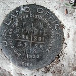
Mike, This is called a Standard Corner, it is the controlling monument along the Township Line between Townships 18 and 19 North. CallawayMT