


rragan
-
Posts
190 -
Joined
-
Last visited
Everything posted by rragan
-
Appearance of Block Party icon. When there were only ~5000 of these and not showing up on maps, the icon color was not a problem. In 2025 there will be a lot more on the map. They are really hard to discriminate from traditional icon colors. See pic. Can this be changed some before 2025?

- 1 reply
-
- 1
-
.png)
-
Yes, I can copy the text and paste it into the translate app as you say. I was hoping to allow text selection because then more options (including Translate) become available on iOS. Not sure if Android offers this on selected text. Making links live in AL text so you can click on them would be be great further refinement.
-
It's frustrating that text cannot be selected in an AL. It would make translation easy (at least in ios, nos sure about Android). When text is selected, Translate is one of the options. It sure would make international labs more easily doable.
-
Would an event covering how to plan and create cool Adventure Labs qualify? No container is involved (but Earth Caches lack one too). Just asking as I guess the answer is likely to be no.
-
Switching from the Search Map to the Browse Map gives an empty green nav bar at the top. There is a JavaScript error that causes things to stop painting. https://www.geocaching.com/map/#?ll=37.36156,-122.07664&z=14
-
Can anyone share a general mega planning event template to help folks planning one? I'm thinking, timelines , activities, merchandise , ... but anything can help.
-
And it's not all Germany. Here are German event counts broken out for 2021.

-
Geocaching events 2019-2021 during the pandemic for the US and Europe. Data from PGC.


-
UI color choices on Call to Action button is poor
rragan posted a topic in General geocaching topics
Several places on the site now use a dark blue button with black text. This combo is hard to read. Consider choices based on Ui color combos that are easy to read. -
View Larger Map on an archived cache hangs the web page
rragan replied to rragan's topic in General geocaching topics
I don't care if they don't want me to zoom in on the larger map for archived. Just don't hang my browser tab. Say no larger view available or just remove the link but hanging is not cool. -
If I search explicitly for an archived find of mine (GC4AFPT TNLNSLTFTC!) and click on View Larger Map a modal error dialog appears that cannot be dismissed. Clicking the X to close just makes it reappear. I have intermittently seen a variant of this problem when I drag the window and click "Search This Area". If I drag and click search too quickly sometimes I get a similar blocking dialog but with coordinates showing. I assume this problem is due to firing a search while another search is underway confusing matters. Still, it should not do this.

-
And here is the tale of using gsmx2's AL's without data strategy for the hard part of the CA-1 highway series. gw0143 and myself (rragan) tackled part of the CA-1 Adventure lab trek - the hard part where data is scarce to non-existent. We are both Verizon customers so your carrier mileage may vary. We started with the two locations in Watsonville as this suited our route over from Mountain View. The other 8 in the lab will await another day. Off to a good start and enjoying the new UI. Then Pajaro River to Castroville went smoothly as did Castroville to Seaside. We were hitting our stride. Seaside to Monterey is where our troubles started. Note that this is well before we expected to be lacking data. The symptom was: submit an answer and endure 3-5 minutes of spinning cursor of death before being told to submit thw answer when we had Internet connectivity. This was in the heart of Monterey with full bars of LTE on the phone. A second try also failed but then the 3rd went through after a few minutes. First this afflicted me and so I figured IOS but not long after gw0143 ran into it and he uses Android. The problem would come and go but eventually we persevered and got all of this lab submitted. My theory is problems with the Adventure servers led to them not responding which was interpreted by the App as my being offline as no response ever came. This cleared up later so maybe there was some maintenance or something I opened Carmel-Andrew Molera on my primary phone and got the first two locations to work but then hit the spinning delays again. Figuring I might lose data soon anyway I just left the lab open and set the phone aside. I had tried one of the secondary phones earlier and saw the same spinning problems. In any event, I committed the secondary phone #1 on its powerbank and getting data via the mobile hotspot to loading the farthest away set of labs (Ragged Point-San Simeon). The secondary phone #2 got Lucia-Ragged Point loaded. At this point I realized I needed more phones. Primary phone was on the Carmel-Andrew Molera segment and the other 2 had segments near the end but Big Sur-Lucia was not covered. Turns out gw0143 covered it on one of his phones. We also killed all the apps on our phones except the AL app and went to Airline mode. We tooled down CA-1 enjoying magnificent weather and beautiful scenery. During the trek we picked up 13 other caches which cost us some time but some were co-located with an AL location and some we needed for Southern California DeLorme Challenge. When we reached the Elephant Seals and got restored data signal we proceeded to unload our "constipated" backed up-but-ready-to-answer phones. This went quickly. We had recorded all the answers so banging in 10 of them would clear a phone. It sure felt good to get a real device back that I didn't fear knocking out of the AL app. For my Big Sur missing one, we tried a trick I had heard of. gw0143 logged out of his account on the phone for that segment and I logged in. Lo and behold, I was then able to log all 10. What I've learned is it would be possible to do it with two people each with two phones and via the logout/in trick so 4 no signal segments can be logged. We called it a day after Cambria as we had burnt all the daylight on these short days. Even so, we got 87 labs and 13 other caches for a nice even 100 finds. 8:30 AM departure and back home at 10 pm for a longish day. We saw some bugs off and on in the app. First it would declare a Lab completed even though it wasn't. Youi could tap an uncompleted location sometimes on the map and get to them but other times the tap did nothing but you could go to the list of all locations and resume that way. Annoying but should get fixed. The message “You cannot submit correct answers offline. Check your connection and try again.” is confusing. Only if you are clever can you infer that this means your answer is correct. Better phrasing would be "Correct answer. Remember it and enter it again when you are online.
- 1 reply
-
- 1
-

-
Let me offer a recently reincarnated challenge trail we put out around here. A few pre-moratorium caches are in it but most are under the new guidelines. The goal was to make interesting ones under the new guidelines. Feel free to crib ideas as some of these were cribbed from other creative folks. GC3F12D Neglected Cache Challenge GC55XPN The Bigcall Challenge: A Baker's Dozen GC55XP0 The Bigcall Challenge: Nifty Fifty GC980EH 365 Unknown Dates Hidden Challenge GC980EK Feet Under the Sea, Head In the Clouds Challenge GC980EJ All The Attributes Challenge GC9838K The Golden State Challenge GC9839B The Best Finds Challenge GC9838Z The Perfect Country & Western Song Challenge GC9834G Globetrotter Challenge GC9834D The Island Life Is For Me Challenge GC9838F Virtual 👻 Border to Border Challenge GC98388 5 states*100 Finds Iconic Challenge GC9838P Iconic Traveler Challenge GC9834N Every Day Hidden Challenge GC98396 The Bay Area Puzzlers Challenge GC98393 The Taking a Long Lunch Challenge GC98341 Largest Counties Challenge GC9839N Road Less Traveled Challenge! GC9833X Wherigo Quarter Century Challenge GC98347 So Easy a Child Could Do It Challenge GC9838D It's Five O'Clock Somewhere Challenge GC995K7 Mysteries Across The USA Challenge GC995K2 5 Types x 10 States Challenge GC99842 Historic Alameda County Caches Challenge GC99A3G The Demented Diminishing Dozen Challenge GC99AD4 1000 km Altitude Challenge GC99ACQ The Blue or the Gray Challenge GC9986G Hazards of Geocaching Attributes CHALLENGE 313 GC9986J Accessible Attainable Attributes CHALLENGE 1313 GC99X8B The Lazy Cacher Challenge GC9A2N2 The Good N.E.W.S. or Bad N.E.W.S. Challenge GC99EMN The 3.5 Billion Year Challenge GC99AE7 Well-Traveled Cacher: Degree Squares
-
Further on this topic now that Perseverance has landed. The recent extension to Earthcaches showing geology and features of planetary bodies exemplified on Earth is a perfect fit for the naming scheme to be used with the Perseverance Rover. "As Perseverance explores the Martian surface, the science team will assign unofficial names to especially interesting regions, features, and samples. This naming system is similar to the one used to name the Mars locations that the Curiosity rover has explored on Mars. For Perseverance, the team has divided up the entire landing site, Jezero Crater, into squares. Each square will be matched to national parks and preserves on Earth with similar geology. As a nod to the diversity of the international science team, the plan is to find matching sites in countries that have contributed to the mission. As the rover explores Jezero Crater, any time the team sees an interesting feature, they will name it for a corresponding location here on Earth." Creating a matching Earthcache would let us explore Mars by proxy.
-
The interactive parts were done in JavaScript hosted on a website with free hosting. The JS gives you a code to enter to complete the AL location.
-
They put release note updates for the Geocaching app. Why not the Adventure Lab one? Different team I suspect not clued into the procedures. The update was not on FB either.
-
Doh! Grabbed wrong screen capture.

-
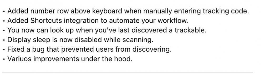
Shouldn't release notes be included in that forum? There don't appear to be any. The latest iOS update, for example.
-
In the light of complaints about the Adventure Lab App using the phone battery more heavily than other caching apps, I tried to gather data and see. The settings were: - iPhone 11/iOS 14.2 - Max screen brightness on - All other apps killed - Background app refresh off - Screen sleep: never - Battery 100% (full) at start - 1 hour duration for each experiment - Radio settings varied because the AL app won't run in airplane mode Baseline for screen usage: airplane mode max screen for an hour consumes 13% of the battery Adventure Lab Apo: Just wifi on. Device was moved around during the hour while the app showed "Get Closer" screen with switch to Compass screen now and then. 14% used so breakdown: AL App 1%, Screen 13% Cachly: Device moved around during the hour with app doing an alert on target proximity to be similar to AL case. Note: all radios were on accidentally so Cellular and Bluetooth may have taken some power that AL experiment didn't see. 15% used so breakdown: Cachly 2%, Screen 13% After completing the Cachly experiment, I turned on background app refresh and the battery dropped quickly to 17% used. Only apps up at that point were Mail and Facebook which suggests you might not want these running, even in background, when you are out caching. HQ Geocaching App: Device moved around during the hour with app navigating to a cache. Map screen used. Cellular radio on. Others off. 18% used so breakdown: App 5%, screen 13% Conclusions: My main inference (no surprise) is that the phone screen will eat most of your power. So why the perception that the AL app uses much more of your battery than other caching activities? My suspicion is that ALs lack good map support compared to mainline geocaching apps so wandering around trying to get closer means you have to keep the screen on all the time. With other caching apps, you can see the trail where the cache is and you can often put the phone away for some time until you get close. With Cachly proximity alerting, you can do one better by putting a proximity alert on the target and put the phone away -- almost no screen usage so most of the 13% screen usage vanishes. Limitations: - Battery usage numbers are pretty coarse on iOS so at least +/- 1% error - I cannot comment on Android usage as I don't have one. - An experiment I did not try was to use the AL app vibration when near the goal to reduce need to look at screen. This assumes it works in background mode
-
AL - 'Download completion statistics' link not working
rragan replied to Deepdiggingmole's topic in Creating Adventures
There is no mechanism for opt-out of showing who did the AL unlike logs on the main site so I'd guess privacy legal worries led to its removal. -
What vintage of iPhone? Age of battery?
-
Seems very reasonable to me. A bit over a month ago HQ said "we are working on improvements to the login process for the Wherigo® app for iOS and anticipate those will be completed in 2-3 weeks. This will likely require you to download a new version of the app for the updates." Also if you do move to iOS, take a look at Cachly - a really good choice for cachers on iOS.
-
Feedback from a FB thread on battery usage. More comments are likely over there including some indication of user platform in use. Still, some attention to optimizing for battery usage in the future might be in order. "I use the main hq app and I can run it all day long with only minor boosts from my in car charger. 40 caches later still at 80%. The AL lab nearly zeroed my phone in under 3 hours. With the AL app open, screen off, phone charging in the car charger for 20 minutes it didn't gain 2%. I finally closed the AL app and 20 minutes later I had gained 40%. The AL lab app definitely kills your battery. Bad programming. I regularly run 4 apps (waze, life360, geocaching and Allstars, not to mention google) at the same time that are using the GPS and maps and don't have a problem ." "AL apps poorly optimized I confirm it's eating battery like crazy" "The AL app is _by far_ the worst battery eater I have on my phone. My phone (and its battery) is not the newest one, and playing AL depletes up to 50% of my battery within 1 hour! WIth "normal usage" during caching (GPS active, map is sometimes displayed, etc.), my phone lasts about 4 to 5 hours. I never go out caching without an external battery pack . And despite the high power use, the overall performance, e.g. when trying to zoom/scroll the map, is by far the worst of all map-displaying apps I have. Zooming the map becomes almost impossible, if a lot of ALs (40+) are displayed. OTOH, e.g. Google Maps is perfectly working even in city areas where hundreds of symbols appear on screen at the same time."
-
I can't say a lot but I've been a beta tester for the revised iOS Wherigo app. It will be a newer look and some new features. That said, if the cartridge itself has problems this will not magically fix those. Hopefully the wait won't be too much longer.
-
I'm sure there are multiple channels of communication because not everyone is here or on Facebook, etc. Getting feedback from multiple channels has the best chance of hearing from a larger audience. I can understand directing Facebook users to use the app. Facebook has a way of making a post vanish after you have seen it once. Not easy to go back and look at it again

.png)


