


monkeykat
-
Posts
194 -
Joined
-
Last visited
Posts posted by monkeykat
-
-
Not quite as historical, or maybe interesting as some of these other stories, but I always chuckle when I think about this story.
I was searching for OF2603 in Hilton NY, one of several marks I identified that would get me a "2" for the BM contest. The mark is located in a pleasant neighborhood in a suburb of Rochester. There was some road construction and detours around the area, which actually gave me a chance to get some roadside benchmarks quite easily as there were big detours and "Local Traffic Only" signs around.
Anyway. This mark had a nice witness post next to it and cover, so I pulled over and began to photograph the area, and lift the cap to dig out the soil covering the mark. I had my bag of benchmarking gear, gloves, GPS, PDA with datasheet, and of course my orange reflective vest of invisibilty on. While I was trying to scoop dirt from the tube to get a good photo, a man came up to me and asked what I was doing.
Nice Man: What are you doing.
Me: I'm trying to verify the existance and condition of this survey marker.
Nice Man: Well that's it right there, what else is there to verify.
Me: I want to read the disk designation and photograph it.
Nice Man: Well there's the center of the tube, isn't that what you need?
Me: I want to photograph the disk inside.
NM: Is it for the construction down there?
Me: No.
NM: Are you re-surveying the property lines?
Me: No.
NM: Are they widening the street?
Me: I don't know.
NM: What agency are you with?
Me: No agency, I do this as a kind of volunteer in my spare time. I report my finds to the NGS.
NM: Hrmmf, sounds like you need to get a life.
Me: Well, my wife is usually sleeping...
NM: No. <louder> I said you need to GET A LIFE.
Me: Well, I was trying to say that my wife sleeps in on the weekends, so I spend my mornings looking for these marks as a hobby.
NM: Why would you do that?
Me: Well its fun to find markers that are missing, or have been placed many years ago, or maybe nobody has seen or used in decades.
After he understood what I was doing, this man proceeded to tell me he was a landlord 3 houses down, and that he does it full time for 3 properties. He explained how tough a job it is, and that he had been to court 3 times last year, and one tenant made him replace his stove twice. After the second time, he said if it breaks again, buy your own. He was a pleasant fellow, just seemed a little put out that I had all this spare time to spend looking for little metal disks that were "clearly visible". 15 minutes later we each went on with our business.

-
...and it is not completely fair that I take total responsibility for this- especially legal responsibility. I could never have placed a 'geocache' out there without geocaching.com...
When the geocache police came to my door and put a gun to my head, and told me to place a cache in the woods, I shut the door and ran away. How can you not be responsible? And how can anyone even "help you" when you don't say what cache you want removed. Jeesh.
-
Just noticed that Yahoo Maps has upgraded its interface and usability. Looks more like Google Maps now, but of course they had to add their own "touches". Instead of zooming in with the "+" on top, and out with the "-" button on the bottom like Google, Yahoo has them reversed. Also, they have map view, hybrid, and satellite views, but they place the buttons in slightly different order than Google usually does.
The interesting thing is that they also seem to be using a different mapping agency. I know for me, this means that areas that are blurred because they are low resolution photos in Google Maps, actually have a nice resolution on Yahoo Maps.
Just another tool for getting a view of the area.
-
Hope its ready to get pounded with recoveries.

Perhaps everyone with a last name a-m can log recoveries from 7am to 12pm, then n-z can log from.......
-
Had a long day of geocaching/benchmark hunting on Saturday, so I took it easy on Sunday, meaning I was able to play around with the Google Maps Application for a while.
Recent Updates:
1. Added a Clustering Algorithm to try and average the number of marks available in the viewing area and display a maximum of 100 at a time. Works pretty well I think. Has a problem where it displays a maximum of 199 marks at a time, but once you reach 200 it has enough marks to average. Also, near water you can get some odd marks, like Cape Cod where it averages some mainland and some cape marks and gives you a marker in the ocean.
2. Tried to update the FAQ a little. I will link to the benchmarking FAQ on the geocaching page at some point.
3. Update the state page "template" to have a larger map and link to the other states.
4. Added Arizona, Maine, Vermont, New hampshire, Connecticut, and New jersey to the database of states available to view. I will add more soon, so if you want your state now, send me an email.
The index page will remain:
-
-
Seemed like I should have found more considering how long I was searching, but here goes:
05/26/07:
OF1979 - REG - Poor Disk Picture (understand if it doesn't count towards contest)
-
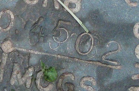
Here's a disk I came across last weekend, that seems to clearly have another stamping below it. Is this somewhat common? First one I've Seen.
-
I tried to download some shapefiles to play with from the NGS site, but they are returning empty files (or empty ZIP containers). Is this a known site problem or is it a known ArtMan problem?
TIA,
-ArtMan-
Doesn't look like just an 'ArtMan' problem. I was unable to download shapefiles when using the "Shapefiles" button. I tried NY State and selected Monroe County. I got an empty ZIP file. I used the Archived Shapefiles button in the past to grab information by complete State. That one still appears to work, as I could download Delaware this morning. I've only used the Archived link in the past, so I am unsure if the empty ZIP files are a result of the upgrade, or a problem from before the outtage.
-
-
Some weekend finds:
05/19/07:
05/20/07:
-
Let's get this thread back on track. I've been working to fix up some of the backend stuff for the google maps API I am working on. Sunny weather and the benchmarking contest have been foiling my coding attempts, but I'm getting it done. I have been working on sliming down the SQL database I store the shapefile data in. Since all that data counts against my disk quota, I am only keeping the essential data from each shape file. I have my shapefile loader php script working great, so adding new states to the database is a breeze. (I do have tons of disk quota left, it just makes sense to slim it down in case I need that space for the future)
I've also been trying to get a generic "state page" template done, since all 50 states will need a similar looking page, its best to finish that up before I create 30 states, and have to modify them all by hand. 1 template for easy modification. Then small customizations later.
I moved the latest maps to a subdomain on scaredycatfilms. The newest maps can be accessed from: http://benchmarks.scaredycatfilms.com/. Soon I will take the old pages in the /maps directory down, and redirect users to the new ones, if people haven't gone there yet already.
I added Hawaii last night as a test to see how quickly I can add a state. Only took about 10 minutes for the first try. I think the time will drop down to only a few minutes once I refine my process.
I am going to try and work on clustering soon to increase speed and preformance. Right now the pages still seem to bog down when viewing states at a high level. That's because I pass back all the potentially viewable points, but only display the first 100. So if you chose to view the entire state of California, your browser memory would be filled with 66,000 points, but only displaying 100 of them. I'll see if my clustering works, and if it makes a difference.
-
Recoveries from 05/16/07
With OF1872, that "D" gives me 2OLDFARTS bonus.
Reference these previous recoveries:
-
Had a pretty successful day hunting on Saturday 05/12
The rest of these are judges discretion. I am 100% confident of the finds, but dang it all, I could not get these disks cleaned off. Many were 1-2 feet deep in their tubes, and most were covered with a 3 inch layer of mud I had to scoop out. Photographs were tough into the pipes, mud was tough to get off. I tried water, but it filled the pipe up. I tried powder, but it combined with the dust. Also tough when they paint the marks because then its tough to get any definition with the numbers. And no thanks to Monroe County for not stamping the designation in the covers either.

-
Recoveries from 05/06/07, trying to finish off my 2OLDFARTS bonus, so far, just missing the 2
-
I love the topo map option too! I was thinking of getting a mark in PA last weekend called TUSSEY. It looked like it was only 300-500 feet from a major road. I told my wife it would be an quick easy find and no NGS reports for quite some time too. While I was down there in State College PA I told my brother in law he had a great view of one of the ridges surrounding the college. He told me it was called Tussey Ridge. We got home and checked the topo map, and sure enough station tussey was about 500 feet up on top of the ridge. We ran out of time and didn't make it to the mark, but it would certainly have been a surprise had I showed up not in my hiking gear.
-
Its very disappointing about going out for more "urban" marks and finding them all missing, with no witness posts. A 1 for 11 evening, with most marks looking to be covered by expanded roads. I'll have to head out to the countryside again...
-
If you have some spare time, I would be interested in hearing about your clustering algorithm. I haven't implemented clustering yet either, and it seems a necessary evil when dealing with google maps. Are there any web sites you used as a reference when deciding how to cluster?
-
-
Meanwhile, monkeykat, what would it take to get you to setup California? HUGE number of marks (almost 63K marks in 2005)...
Oh yeah, one suggestion: I wouldn't mind seeing another link for the GC page (if there is one).
Klemmer
Done. I think California is up and working now from the index page. I was also thinking of adding the geocache link, which was pretty easy to do. When searching the maps I saw recoveries by "GEOCAC" and wanted to see the pictures and logs, but there was no link. Now there is.
Enjoy.
-
I added Massachusetts and Pennsylvania last night. I also made the index.html page a startup page with links to each page dedicated to a state that I have completed. Like a true index.
Benchmark Test Viewer State Index
Plan on adding the little scale in the corner to show distances. I also noticed that if two marks are at the exact same coordinates, only 1 will be displayed when the user clicks on it. I'll have to figure out how to display more. I think I may be able to do a tab-ed marker display.
I think in the future, I will prbably dedicated a domain to these viewers. Something like "benchmarks.scaredycatfilms.<om" or similar. Then update the meta data, and it'll be ready for all to see.
As a side note, google maps has very detailed images of areas in North Korea. You can view the capital Pyongyang and see an even more detailed satellite view than about 5 miles down the road from me. Interesting thing is that it is broad daylight, and there are almost NO cars on the road. What an interresting country.
-
-
Hah! You are totally right, no matter when I actually make the submission, as long as I date it the time I actually recovered it, then the entry in the NGS will be correct as of that time. Brilliant! Even if it gets destroyed the day after, it will still have been a correct recovery on the date I submitted. Funny I didn't look at it that way. Must be this "Left" brain of mine.
-
well that clarifies it, thanks John. I just didn't want to miss out on any DNF points if there was somehing I was missing in the rules. This contest must be a tremendous amount of work for you, and I think you are doing a great job.

Google Maps API and Benchmarks
in Benchmarking
Posted
Another status update. I have all 50 States added to the online database. I think I will add Washington DC soon, as it has a separate shape file. Enjoy Everyone. Maybe I'll add some of the US territories if I have the time... any interest in Guam?
I hoped to add a polyline around each state, but I haven't gotten them to work yet period. Let alone around a state. It bears more investigating.
Expect some minor tweaks here or there. But mainly cosmetic, I think. The shape files are all loaded in the database. Statistics Are as Follows:
States: 50
Apprx Marks: 815,500
Apprx Size: 100MB
Keep in mind, I only saved the PID, html link to the data sheet, LAT, LNG, PID, Name, Last recovery, condition, and by whom, to keep the data size down.
As always, the link should remain the same:
http://benchmarks.scaredycatfilms.com/index.html