

Holtie22
-
Posts
247 -
Joined
-
Last visited
Everything posted by Holtie22
-
Andre Try this site.
-
The term "traverse" in surveying does have a very specific conotation. See page 9 of this document. This means that a traverse station has been located by a series of angle and distance measurements. It also implies that the traverse station was physically occupied by conventional surveying instruments in order to complete a closed figure, or a check on the measurements. Can't do that on top of a radio tower! I believe that the towers were originally located by conventional survey methods measuring to the center of the pulley thingy on the concrete base, and that they are therefore not destroyed, (but not really of much use for geodetic purposes, either).
-
Paul I would love to come down and help you on this one, but I'm tied up on weekends through mid-October. Maybe after that...? In the meantime there is one more thing you can check. With a simple builder's level (the kind that sits on a tripod, not the long bar with bubbles in it), and a sighting rod or tape measure, you can determine the relative elevations of RM 1, RM 2, and the bottom of your hole. According to the datasheets, RM 1 = 97.9', RM 2 = 98.2', and the station = 99.2'. These elevations seem to have originated when the RMs were set in 1943 and should be accurate to the nearest 0.1'. If the bottom of your hole is still more than a foot higher than both RMs, you need to dig deeper. If the hole is lower than the RMs, there is a good chance the site has been altered by heavy equipment. I'll take a look at the calendar and see if there's a date that will work for getting down there. Bob aka Holtie22
-
This site might give some insight into early topographic mapping.
-
Congratulations Paul! Great progress indeed! Your persistence pays off once again. With 2 well-defined points to work from, this station is as good as found. Even digging through hard-pack becomes a whole lot easier when you are confident that you are digging in the right place. Send up a flare when you find it.
-
Paul - Did you look any further for RM 2?
-
Paul- I went to the source you gave and got a better quality image of the survey plat. It still doesn't line up exactly with the blue lines, and it depicts the building about 2.5' NE of where the 1953 tie measurements would put it. You should note that the fence line is depicted on the plat as lying a foot or so inside the tract boundaries. (See double blue line). This is confirmed in the 1953 recovery report, where the distance from RM 1 to the fence is given as 19.6'. In the same report, however, the SW fence corner is described as being 84.2' from the station and 6.8' from RM 2. This puts the fence corner right on the tract boundary rather than a foot inside it. We may be dealing with sloppy measurements from 1953. Scaling the distance from RM 2 to the corner of the bright square, I get 17.5'. The uncertainties associated with this image may be even greater than what we have seen on the survey plat, again about 2-3 feet.
-
TillaMurphs - I use AutoDesk Land Development Desktop, which has AutoCAD Map built into it, allowing me to manipulate images within AutoCAD. Paul - Once the image is in AutoCAD, properly oriented and scaled, it is a simple matter to measure between any two points. The difference between your measurement and mine is probably related to scale factor. There may also be distortions in the image due to how it was digitized. Was the original scanned or photographed? If you examine the last overlay, you will notice that the blue lines do not lay exactly over their counterparts on the survey plat, yet the blue lines were input using the dimensions given, so they should be more accurate than the image. I attempted to scale and orient the survey plat based on these lines.
-
I have added to the survey plat image a hypothetical building footprint from the Google image. If my assumed dimensions are correct, then my best estimate of the station location would be 22' SE of the SW corner of the addition, and 18.5' SW of the SE corner. Those numbers would change to 19.5' and 17.5', respectively, if I shift the footprint to match the tie distances to the station and RM 2 given in the 1953 recovery report. So you can see there's a lot of uncertainty with this method.
-
Paul Maybe this will help - I plotted the objects from the box score, then added the dimensions from the survey plat, (which appears to be based on either grid or true north - the difference being about 3/4 of a degree). I then overlaid that information with the image of the survey plat, and also with a Google Maps image from ScaredyCat's BM Viewer. Here are the results: I scaled a distance of 39' to the former SW corner of the barracks building, and 48' to the SE corner. I wouldn't guarantee an accuracy better than about 2-3 feet, however, based on the overall fit. With a survey instrument, you could occupy a random point where you could see both MY4964 (the center of the tower should suffice), and RM 1. Then perform a resection to obtain occupied coordinates from which you can stake out the location of MY0235. This method (depending on how well you can determine the center of the tower) should get you within a few inches of the actual station, narrowing the size of the hole for digging. Of course, not everyone has access to the necessary survey equipment, but if the folks at Halibut State Park are really interested in unearthing this mark, I might be able to help.
-
Unlisted survey marker along AT in Holmes, NY
Holtie22 replied to Team Bacmac's topic in Benchmarking
There isn't one that I am aware of. The survey plats for the Exterior Corridor Boundary are recorded in the appropriate Registry of Deeds, and depict the locations of survey markers, including diagrams of ties to witness objects for individual markers. Here's a sample: -
Unlisted survey marker along AT in Holmes, NY
Holtie22 replied to Team Bacmac's topic in Benchmarking
bacmac Did it look like this one? The Geocaching Benchmark database is a circa 2000 snapshot of the National Spatial Reference System managed by the National Geodetic Survey (NGS), part of NOAA. Although it includes over 700,000 markers across the US, there are many times more than that number that, for a variety of reasons, are not included. The benchmarking FAQs explain this more fully. The mark you found is what is known as a cadastral survey mark, meaning that it is related to a property boundary, in this case the Exterior Corridor Boundary of the Appalachian National Scenic Trail. The stamping means that it is marker number 25A in Segment 270, which is located in the state of New York. For reference the one pictured above is marker number 102 of Segment 206, in Vermont. Incidentally, it is also one of the very few AT markers included in the NSRS. To post a photo, it has to already be uploaded to a site online (such as a benchmark log page). You can then link to it using the photo icon in the post browser. -
Bill93 Sounds a lot like this series of murder mysteries written by a NY surveyor. I read and enjoyed all of them, and would love to see more surveyors featured in popular fiction. Please send me what you've done and I'll let you know what I think.
-
Richard Fantastic Find!!! What a wonderful job of research and recovery. Having grown up in Pelham, NH, I have known about this marker ever since our 4th grade unit on local history (1964), but I have never seen it. My father owned Merrimac Optical Company, located at the corner of Pulpit Rock Road and Coburn Road, an area that has now been excavated as part of the huge gravel quarry that straddles the state line. (It is interesting that the road is named Coburn in NH, and Colburn in Mass. - your research seems to indicate that Coburn would be the more correct spelling.) My father was an avid outdoorsman and had told us kids that he had seen this marker, which is pictured in many local history documents, but he never said exactly where it was. I used to work at the optical shop in the summer and after school, and had gone looking for the Boundary Pine monument on occasion with my brothers, but we were always searching along the section of state line between Coburn Road and Route 38. We didn't have ready access to the materials that you were able to find giving an accurate location. (Besides, we were just kids out looking for adventure!) As a side note, it is interesting that the 1740 decree of the King that you cited also provided the basis for NH's claim to the land that became Vermont. Then-governor Benning Wentworth interpreted the phrase "...due west across said river until it meets His Majesty's other Goverments" to mean that New Hampshire extended just as far west as Massachussetts, ie. to within 20 miles of the Hudson River. Wentworth began issuing charters for Townships based on that premise in 1749, (the first being somewhat immodestly named Bennington), and the great dispute with New York was off and running, finally settled by the people of Vermont declaring themselves to be an independent republic in 1777, and admitted into the Union as the 14th state in 1791. Thanks for your extraordinary efforts in recovering this unique mark and in resurrecting a quest of my youth.
-
duplicate post...
-
Foxtrot It would appear that the only reason this mark, whose main function is purely cadastral, is included in the NSRS, is because it was used in a line of levels that was published by NGS. The horizontal coordinates are scaled. Regarding your last question, I've often wondered the same thing myself!
-
Paul- Looks like a great find, and I would agree that the drill hole you found is probably the station mark... But - without the corroboration of any of the three reference marks, I might be a little circumspect about claiming this one right away. I would also hesitate to provide measurement data to newly created reference marks if I were not trained in proper measuring technique. Some sources of error that can creep in: tape not held straight (bent around underbrush); tape not held level (at least one end should be plumbed over a ground point so that you are measuring a horizontal distance, and not a slope distance); tape is constructed of inappropriate material (cloth, plastic, nylon, etc. can stretch significantly); tape is not pulled tight to proper tension (too much sag or too much stretch - even with a steel tape!); temperature correction is not applied (tapes change length with variations in temp); tape is not calibrated to a known standard (now we're nitpicking, but you get the idea). That's just with regard to the distances - direction is a whole other kettle of fish! While I am sure that your intentions are forthright, it should be remembered that an absence of data is way better than an abundance of inaccurate/incorrect data.
-
Wow Greg, great find! Your perseverance definitely paid off! To post a photo, it has to already exist online somewhere with a URL. So to post one of yours, I simply copy the URL from the photo page, then paste it into the prompt box that you get when you click on the tree icon in the post page. Did you get a shot of the nail? When the description says that the station can not be occupied, that's not the same as saying that it is inaccessible. It just means that you can't set up a tripod over the station marker itself, which is why they used the eccentric station, marked by the nail with a cross. The parapet offered a better site for a permanent marker location, but with limited access to survey instruments. So, post some more photos if you have them!
-
Margot From Google Earth I got the following coordinates for the SW corner of 14th St. & 2nd Ave. N40 43.939 W073 59.108 The cursor coordinates show up in the bottom left corner and update as you move around.
-
Triangulation Station Marker in Grand Canyon
Holtie22 replied to godcandoitall's topic in Benchmarking
The station you found was part of the control for a mapping project of the Grand Canyon done by the Boston Museum of Science in the late '70s. Here's a link to the report, (thank-you Zhanna!), and a copy of the page with station Hermit described. -
k5knt After reading all you wrote I believe that you have found the correct mark for this PID. The apparent conflict in the description between "top of the balustrade" and "set vertically" can be explained as confusion on the part of the original scrivenor. CB0132''AT SAN ANGELO, TOM GREEN COUNTY, 0.7 MILE WEST OF THE COURTHOUSE, AT CB0132''THE PAT MURPHY BRIDGE, NEAR THE MIDDLE OF THE BRIDGE, AND IN THE TOP CB0132''OF THE BALUSTRADE. A UNITED STATES GEOLOGICAL SURVEY STANDARD DISK, CB0132''STAMPED 1844.015 AND SET VERTICALLY. I have posted in the past that even though the accepted standard for the term "set vertically" means a disk in the side of structure, rather than on top, it can also be construed in terms of the orientation of the stem of the tablet; ie: you would have to drill vertically to set a tablet on top of the balustrade, while you would be drilling horizontally to set one on the side. The missing stamping might be explained by this note near the top of the datasheet: CB0132.WARNING-Repeat measurements at this control monument indicate possible CB0132.vertical movement. This would also account for the differences between the designation, the reported stamped elevation, and the superceded elevation. Faced with these discrepancies, it would not surprise me that some agency might grind off the misleading stamping. Since you have searched over the entire bridge with no additional finds, and this disk fits the datasheet description in every other regard, I would conclude that this is indeed the mark described, and would be confident in reporting it as found. That being said, as a surveyor I would certainly hesitate to use this mark for any work requiring better than one foot accuracy.
-
JSC- It certainly does appear to be a benchmark, however it does not appear to included in the NGS (or Geocaching) database, the National Spatial Reference System. The "8M" on the top is most likely "BM", while US C&GS stands for United States Coast & Geodetic Survey, the predecessor to NGS. MAG STA means that it was used as a magnetic station. Nice find! and welcome to Benchmark Hunting!
-
The term tablet is still in use today as evidenced by this page from the Berntsen website.
-
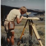
OK, so I didn't walk to the top of 12250' Trout Peak, (this was back in 1983), but I did walk down off the mountain as we spent the rest of the day surveying an oil exploration line.
-
Could it have been this one?