

Holtie22
-
Posts
247 -
Joined
-
Last visited
Everything posted by Holtie22
-
Although not in the National Spatial Reference System (NSRS) maintained by the NGS, the BM does appear on the USGS topo for the Mariposa Grove area: Near the top of the image on Wawona Point. Since in all likelihood this is a true Benchmark, ie. a vertical control point, its elevation would be accurate (adjusted), while its position would be only good enough to place it on the map (scaled). It would be fun to find the many marks that appear on this map, but they could only be logged on Waymarking. Or perhaps you could assist Patty with her Yosemite Benchmarks Page The best coordinates available for this mark would be those collected on site with hand-held GPS. Editted to add link.
-
Looks to me like it's both. A disk was set (probably) by USGS and an elevation was measured by vertical angle. Since this method does not produce third order results, it was not included in the database until a signal flag was placed on the station and it was located by intersection, again by USGS. Those results were good enough for Third Order work, so the station was submitted to NGS (USC&GS). Looking at the stations that Harry mentioned, it appears that there are two (if not three) primary stations plus additional reference marks on this peak, with no recoveries. The 1953 NGS description for NZ1035 HILLMAN makes reference to the USGS station, also called Hillman. NZ1037 LIAO=LLAO ROCK seems to be the same disk as NZ1036 8156, which was set around 1908. Too bad you didn't get up there - this looks like a very interesting set of marks!
-
LOL!! I particularly like the stamping about the accuracy. Has anyone here ever found an embedded coin before? I wonder what the story was behind them doing that! "Growf," if you talk to someone at the county surveyor's office, it would be fun to ask whether they know. Patty While doing some GPS control work for the Exterior Corridor Boundary Survey of the Appalachian National Scenic Trail, we made use of some older control points set by the Park Service. On one of them, the disk had gone missing, but a drill hole in ledge remained. We found that a quarter could be placed in the drill hole in such a way that we could consistently define a precise datum point. With George turned to face a particular building corner, the center of his ear was the datum point. The description was written up that way! We would leave the coin in the hole when we left it, but every time we returned we had to provide another quarter.
-
Help! I'm getting too old to follow directions!
Holtie22 replied to 2oldfarts (the rockhounders)'s topic in Benchmarking
Holtie, Looking at the Right-of-Way plan shows a 0 + 00 with an arrow pointing to the intersection of 89A and the 'Old Road'. Is that the same "53 FT. NORTH WEST OF ARIZONA HIGHWAY BENCH MARK WITH STATION NO. 0 PLUS 00" as mentioned on the benchmark page? If that is the Station No. 0 Plus 00 mentioned then that would put J 52 North West by 53 ft. and not East? Thank you for the link, it is very informative and shows where the old road went winding back and forth across the now currant highway. Shirley~ AZcachemeister is correct that nearly every highway project has a starting point with station 0+00. The one indicated on this plan is for a 1937 project, so it still came after the benchmark, although there is a note on this 1938 plan to indicate that the surveying was done in 1933. What we need are the highway plans, if any, that existed at that time. I couldn't find any on the AZDOT website. -
Help! I'm getting too old to follow directions!
Holtie22 replied to 2oldfarts (the rockhounders)'s topic in Benchmarking
OK, here's some more fuel for the fire. These 1939 Right-of-Way plans for U.S. 89 show the location of the old road just as Shorelander's topo does, and as foxtrot_xray (road geek) hypothesized. -
Help! I'm getting too old to follow directions!
Holtie22 replied to 2oldfarts (the rockhounders)'s topic in Benchmarking
John I'd be inclined to look where that same ditch, .2 mi east of the intersection, crosses U.S. 89 further south, since at this point U.S. 89 is running more E-W. Good luck! -
Here's mine:The Men That Don't Fit In July 18, 2006 by Holtie22 (121 found) Too hot to work! Thought I'd try this game. I picked this as my 1st find since I knew Tom Stone (he kept our Rotary club posted on his round-the-planet hike), and because I surveyed this portion of the AT corridor. Took: Susan B. Anthony Left: Sacagawea Great hiding spot, Rick! Holtie22
-
Someone is stealing used golf balls!
Holtie22 replied to knowschad's topic in General geocaching topics
Because the cache is not at the final coords on my Golf, Anyone?, I used golf balls at strategic points to indicate proximity to the cache. They frequently come up missing - Have you seen this one anywhere? -
OK, so disregard that last post. Turns out it is in the NGS database and on GC right here.
-
Stephen, Although many of these airway beacons were located by NGS and included in the database, apparently the one near Jones Point was not. See the list of airway beacon PIDs on Zhanna's Website
-
How's this?
-
Sounds like you're getting pretty close. The guardrails and telephone poles could have changed considerably in 36 years, but between the 0.8 mile from Cannon Corners and the elevation of 622', I'm guessing it's no more than 140' NE of GZ. Does the rock outcrop extend that far?
-
Unless noted otherwise, distances given in the datasheet description are horizontal, as opposed to slope (cut string), or along-the-ground (measuring wheel) distance. This is achieved by holding the cut string (or measuring tape) level while using a plumb bob to transfer the measured distance down to the ground. The slope distance will always be longer than the horizontal distance. In your case, the 54.2 feet would fall even further north of the centerline than what you measured with the cut string. Does this still put you on a rock outcrop? If not - Could it be on McDonald Road? When was the State Highway moved?
-
Here's the law in Vermont: Ch. 1 Estates in Real Property Title 27 ss 4. Right of Entry for Survey In cases wherein the title to lands, tenements, or hereditaments may come in question, or in order to establish boundaries between abutting parcels, a Licensed Surveyor, with the necessary assistants, wmployed by any of the parties to such disputed title, may enter upon such lands or real estate or other lands for the purpose of running doubtful or disputed lines and locating or searching for monuments, establishing temporary monuments, and ascertaining and deciding the location of a survey, soing as little damage as possible to the owner of such lands. - Amended 1985, No. 116 (Adj. Sess.), ss 2. In 20 years of licensed practice, I have never had to invoke this law, and would be extremely reluctant to do so in all but the most extraordinary circumstances.
-
What does your geocaching title mean?
Holtie22 replied to lil'hobo's topic in General geocaching topics
Even though I was "Holty" all through school, and both of my boys were "Holtie", the real reason for this handle is to honor the memory of my second son, Ian, who died on the first day of 2004. Both boys were born on the 22nd of the month, (different months), and Ian's jersey number playing lacrosse (he was a High School All-American), was 22. The Colby College lacrosse coach had also given Ian number 22, but he never got to play a game for them. Never-the-less, his name and number appeared on the roster (and on the other players jerseys) for the entire four years that he would have been there. I created a TB (Surveyor's Mark), to Ian's memory as well, and am hoping that it will complete its journey before too long. We sure do miss him! -
Not at GC.com. They are not part of the National Spatial Reference System, which is the NGS database used by GC.com for logging benchmarks. You can, however, log them on the sites linked in previous posts.
-
Most Interesting Road Sign While Geocaching
Holtie22 replied to Headhardhat's topic in General geocaching topics
Did this cache last week. -
Pilot Peak is an intersection station which can be seen (and triangulated to) from many tri-stations in the area including Trout Peak. I took this picture in 1983 while surveying for seismic oil exploration. Pilot Peak can just barely be seen on the far horizon.
-
Surveyors beware! Sometimes even the current NGS datasheet can lead you astray as seen in this thread from the POB message board.
-
Here is a screen capture from ScaredyCat's Benchmark Viewer on which I have drawn a 125 yard radius circle around the plotted BM. It falls about 125 yards N of the PC/PT of the curve, and 165 feet SW of the PI of the two tangents. As can be seen, the plotted BM location really doesn't correspond very well with any interpretation of the datasheet description. It is about 575 feet SE of what you called point 1, (the PC/PT of the curve), rather than 375 NW of it. It is about 165 feet SSW of point 2 (the PI of the two tangents). However, it is also about 375 feet (125 yards) North of the PC/PT of the curve coming from the South tangent. Perhaps the picture will help you better than the words! Bill93 points out that the BM icon, which represents the location of the scaled coordinates, lies NW of point 2 (the PI). The plotted BM location is marked by an X to the South of this icon.
-
Tri-station CALF is the only one that shows up in the NGS database on the AT between Jarman Gap and Beagle Gap, although there are also a few USGS benchmarks depicted on the topo. ( You have to navigate from Richmond to Waynesboro in the benchmark viewer, then zoom in and click on TOPO at the top of the map screen.) Of course, there is also the possibility that what you found were Appalachian Trail Survey Markers like this one: These are primarily cadastral markers, although a very few have been used for geodetic purposes and found their way into the NGS database.
-
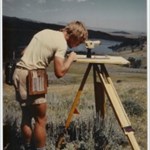
On this day back in 1983, we began our survey at the Tri-Station atop Trout Peak. We didn't have the luxury of waiting for the snow to recede! (Still don't)
-
Stephen Why don't you post a link to the map that shows where it is? I don't know exactly where Badman's Cave is, and I don't see it on USGS topos. Is it north or south of Haines Falls? Do you have GPS coordinates for the cave?
-
The Epping Base Net of the Eastern Oblique Arc
Holtie22 replied to Papa-Bear-NYC's topic in Benchmarking
When you visit Buttermilk, you can see the original 3" drill hole in ledge which was set in 1833 (since filled in with iron pipe in concrete). The monument at Springfield is a 1934 reset. I really don't think one could find any trace of the original earthenware cone, as it sounds like the reset included a sub-surface mark as well as the one found in 1999. -
Datum point