

Holtie22
-
Posts
247 -
Joined
-
Last visited
Posts posted by Holtie22
-
-
After looking at the database link provided by ArtMan, I think the gent from the city may have been right - it could have been an old lamp post base re-purposed as a benchmark in 1978. The description says it is 9.7 feet East of the West line of Leclaire, and 10.4' (not 210.4') North of the South line of Patterson, which is exactly where the coordinates place it in Google Earth. This means that the sidewalks are within the right-of-way limits of the streets, and that rather than being at the intersection of the street lines, it is symmetrically placed inside those lines - right where you might expect to find a street lamp. Is that a conduit (gas or electric) leading into the squared off portion of the concrete? Of course, this interpretation would also mean that the lawn is within the highway right-of-way and not necessarily yours at all!
-
I would check with the local surveyors who were using the mark. I have seen a concrete-filled clay tile with an iron rod in the center used as a boundary marker in my town, although it dated to the 1930's. Given the location at what appears to be the intersection of the right-of-way lines of the two streets, an original purpose as a cadastral marker seems more likely than a benchmark, even if was used as such at a later date.
-
I had been curious about the reasons why the Wall Street Journal would be interested in a story about benchmark hunting, but then I remembered the aforementioned front-page feature story and thought, "Why not?" Erica and I spent a very interesting day searching for benchmarks in western New York. We found some along an old railroad bed, some out in the countryside, one on a small bridge, and one in a post office building. She was full of questions as she took notes, made videos, and followed me around in her quest for more knowledge. We're all looking forward to seeing your story, Erica!

If she's in NYC, then this one is not too far away!
-
As I was driving thru my hometown today, I caught myself relooking at benchmarks I have found previously. I seem to do this a lot on many places I know exactly where the mark is at, when I drive by them. It's like I'm vigilantly watching over them for some reason. Does any other of my fellow benchmarkers do the same, or am I just the freak who needs professional counseling?

Surveyors do this all the time!
-
I located a Benchmark, and want to post the photo, but how do I locate it in Geocaching.com? The closest I can get is a general zip code. I didn't have my GPS with me at the time, so I need to do it by intersection. The coords are: N 34° 08.167 W 117° 18.833
Try this:Benchmark Viewer
You have to select the state (Calfornia), then navigate to the area of interest.
-
Why don't you just ask the surveyor to do the conversion for you? Then you know it will be right.
-
4 years since I last posted - still LOVE my Limmers. I wear them to work, (land surveying), every day (except winter).
-
Thanks for posting this article, wister6813. I have sent the link to the trigonometry teachers at our local high school, where I just spent two days demonstrating how to measure heights with surveying instruments and trig.
-
I have several pics. It is a good bit away from its original location. Amazing how something of that weight would be moved that far. I'll get exact coords when I go back.
From the description, it seems that this Azimuth Mark for Hild 2 was originally located about 2 miles away from the station, about .5 mile north of the county line, and .2 mile north of Blowing Rocks. This would put it around N26 58.630, W080 04.930. It was reported destroyed back in 1964.
The area around Hild 2, meanwhile, looks pretty pricey - probably nor a good place to go benchmark hunting, even though there is a good chance the station is still there.

-
Found this reference mark today, it isn't where it's supposed to be though. It was laying, still in the concrete, on the beach. Trying to figure out it's original location but the gubment website is down. Any ideas? Thanks.
https://scontent-b-ord.xx.fbcdn.net/hphotos-prn2/1378103_10201265471733257_55190335_n.jpg
Do you have coords for where you found it? You could try this site: Benchmark Viewer
-
Actually, the Washington Monument is a poor example since it is not an intersection station, as Dave Doyle can testify!
-
I think Bill93 gave a pretty comprehensive answer, especially given the fact that it hardly matters anymore. No-one doing work that requires centimeter accuracy is going to be using an intersection station. What you have to realize is that even the fact that it is listed in the National Spatial Reference System has no bearing on the owner's (of an intersection station structure) decisions of how they might conduct a renovation/restoration of their structure. With a few rare exceptions (the Washington Monument is one), the Federal Government has no legal interest in what goes on when these stations are modified, rebuilt, or destroyed. So the owner is free to do as they wish, most likely in ignorance of the geodetic significance of their structure.
In the case of Wagner's Main Hall, I doubt that anyone will be doing the measurements necessary to assure that the cupola occupies its original position.
-
PLS 31976 is Mark X. Plog, Land Surveyor.
PLS 38964 is Thomas N. Woldendorp, LS.
Geodatum, Inc. is now known as MXP Consulting, Inc.
The marker you found is in all likelihood cadastral, ie. related to property lines.
-
Mike's app is called Bench Map - works great!
-
I don't think I would take the distances to the North and South marks too literally. I believe that when they were set, the marks would have been intervisible, so the North mark was probably close to the top of the hill near where Camden Drive makes a corner. The South mark is described as being on the side of the hill, so it was probably somewhere between Loudon Heights Circle and the coords provided by 68-eldo. Given the amount of development in these two locations, the likelihood that the marks still exist could be pretty slim. But, if you're going to look, follow John's suggestion and try to keep the Longitude reading on your GPS as close to the center mark's Longitude as possible.
Good Luck!
-
I wonder if the markers you found were associated with This effort?
-
I am looking for this benchmark, MARION with the box score as follows. I have found the reference mark, which is all any one has really found. When reading the box score do I follow the bearing straight down from above? In this case, the benchmark should be on a bearing of 324° 03' 00.0" from the reference mark?

You're right that all of the finds on GC to date are actually of the Reference Mark. If it was properly installed, the arrow should point to the main station, 33.31 feet away. Boy, does this description have problems! The station is described as being 3 feet west of the rail fence, 3 feet north of the rail fence, and 3 feet east of the rail fence - all at once! Even taking magnetic declination into account, the box score azimuth does not agree with the bearing to the reference mark given in the description. Hopefully you can find this mark, (somewhat below ground level), and provide a better description for future searchers. Good Luck!
-
Odd...so I go to a mapping site and find those four listings. When I pan the map around, every time I stop the positions change.
Obviously the online mapping tools are glitchy, but I've never seen markers dance around like this.
I noticed that also. If you zoom in real close in hybrid mode, you will see that the Adjusted mark stays in the same place, but the Scaled marks move every time you click. Could have been done on purpose to show the unreliability of the scaled coords.
-
Ah, but there is mystery out there in the dark, dank woods:
Is there anything left of the fire tower that can be used to sort out the somewhat confusing calls to locate all four of these marks? kayakbird
I added a sketch that should clarify some of the confusion:
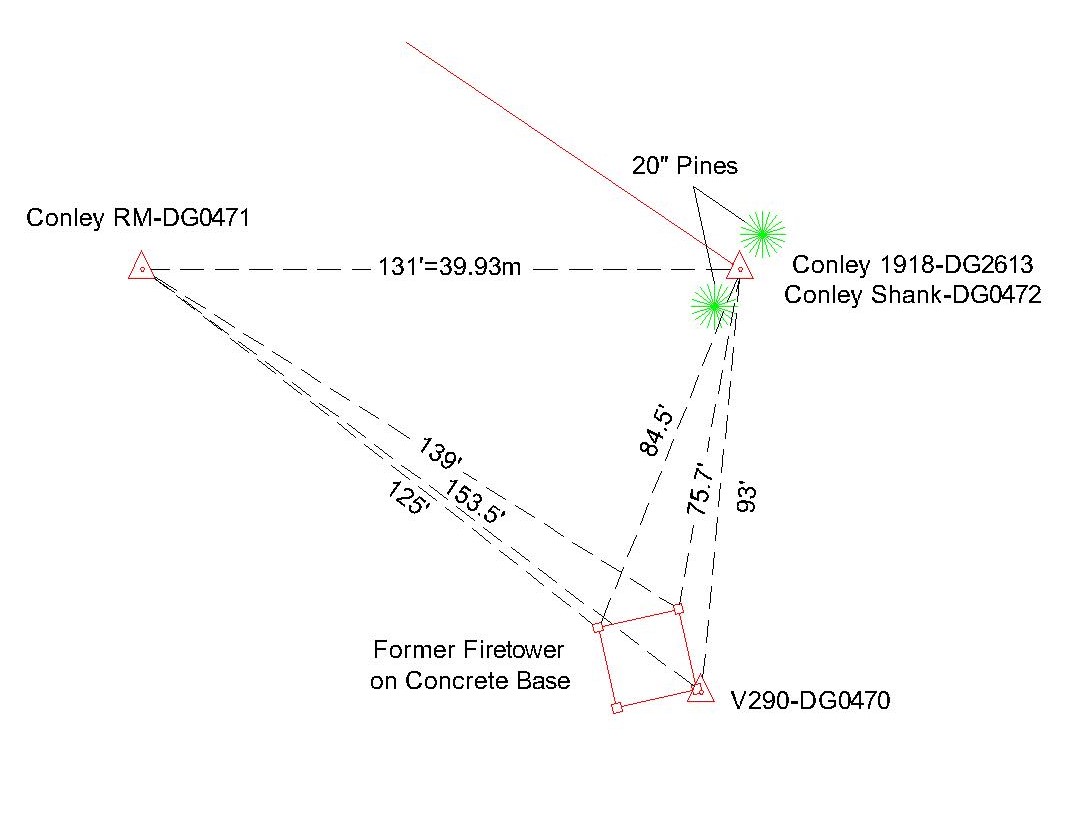
It appears to me that PIDs DG2613 & DG0472 are the same point. The first was for the original tri-station, while the second was for the vertical control established on the same point. The DG2613 coords for this station should be accurate.
-
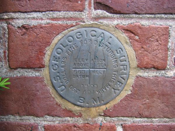
Wondering how old DW0349 might be.
This mark, of a similar style, was set in 1903.
-
Delete Duplicate Post
-
What gives??
Give the expert sleuths here on the Benchmarking Forum something to work with. Hopefully a very clear photo which shows the setting agency, designation and year set (or written info of same). A HH2 Lat/Long in the NGS format of DDDMMSS.s. A description of the setting location - roads, railroads, bridges, culverts and other nearby features.
Chances are that it is a mark that does not have a PID in the NGS Data Sheets, but someone may be able to dig a description out of another source.
Read the pinned subjects at the top of this page. kayakbird
I am guessing that it is this one. Even though Groundspeak operates both the Geocaching and Waymarking sites, only finds on those benchmarks included in their out-of-date database are listed on your profile page. Why? Who knows!
-
Yellowstone:
Nope. That was just my impression from your detailed comments. I am still interested in getting an answer to my question about reading the topo map of the area:
"When looking at the topo map I noticed the east coast practice of indicating "benchmarks" with an "x" and the letters "BM" are not practiced in that area. Can anyone tell me what the "T" or "AT" is indicitive of? Are those non NGS marks (most likely USGS marks) or something totally different?"
The topo map I used was viewed through this site: http://benchmarks.scaredycatfilms.com
frex3wv:
I believe (mainly because of the large amount of hand lettering), that you are looking at a provisional edition of the topo. In which case, the X-marks, unless labeled BM, indicate spot elevations. Not sure of the significance of the AT vs T.
I added a link to a PDF explaining USGS Map Symbols.
-
Finally pulled up the GeoCache Data Sheet. Maybe somebody looked at the 1970 recovery
AC0532 STATION RECOVERY (1970)
AC0532
AC0532''RECOVERY NOTE BY LOCAL ENGINEER (INDIVIDUAL OR FIRM) 1970
AC0532''WYE A 1934 EXCELLENT EXCEPT SEE BELOW.
AC0532''
AC0532''MARKER WAS HIT AND BROKEN OFF ABOUT 12 IN UNDERGROUND. THE
AC0532''AUTOMOBILE THAT HIT IT ROLLED THE MARKER ABOUT FIVE FEET. PERSONS
AC0532''AT THE SCENE OF THE ACCIDENT ROLLED THE MARKER BACK INTO ITS
AC0532''HOLE, SO THAT IT IS OK TO OUTWARD APPEARANCES BUT REALLY IS NOT
AC0532''EXACT.
and decided that it was no good. MEL
No doubt that's what happened, however, as long as the underground mark still exists undisturbed, the station is NOT destroyed.

old unknown marker, city doesn't know about
in Benchmarking
Posted
Many scenarios are possible. A Bundle of Rights