

ddnutzy
-
Posts
153 -
Joined
-
Last visited
Posts posted by ddnutzy
-
-
If some one questions me on what I'm doing I show a data sheet and tell them that I'm a civilian volunteer for the NGS looking for benchmarks and that I download the information to the NGS website. That has always solved the problem.
Dave
-
I'd go for it. If the disk isn't fouled up it would probably only take about 10 minutes to walkout, climb down the truss to the pier, clean it and take a picture of the station, climb up and get out of there.
Dave
-
The benchmarks in question are Army Corps bound marks. The area where the caches and bm's are in the flood plain of the Quinnebaug river and Mill Brook in the southeast section of Brimfield.
Dave
-
I use the tape for sar training on a regular basis laying out 100m pace counts through various types of rough terrain. It also takes quite a beating benchmarking in the mountains. A couple of inches or so one way or another doesn't really matter when your laying it out over all the ups and downs that I run into in the woods.
Dave
-
Dave,
I got a similar 50 meter tape from my local Harbor Freight and the cheap plastic ring snapped the first time I used it. I still kept it in the car and ended up pushing a nail through the actual tape last weekend when I needed a 100 meter measurement (yes, that took two measurements to get). It worked for what I needed it, but it certainly isn't my primary tape.
As for accuracy, I would have to say I will sacrifice a bit of accuracy for less weight. I am not surveying, just hunting for the marks, so I have other tools in my arsenal: a probe, my 20/20 eyesight, my metal detector, and the sheer size of the tops of most benchmark monuments; in case my tape has stretched an inch or so over 50 feet of measurement. I got the cheapest tape I could find from Lowe's (100 foot for something like $15) and have been completely happy with it for three years. I treat it with somewhat less than total respect and if it breaks I will simply buy a new one.
-
One of the members suggested that I submit this BM as it is quite unique. I'm sorry but I don't remember who it was as I deleted the message. I'm also not sure which photo he ment so I picked this one. This is MZ2048 the highest point in CT.

-
Go to harborfreight.com (1800-423-2567) and check item # 36819-ovga. That is a 100ft 100m tape for $19,99. I have one and it is a good one.
Dave
-
MZ2053 (Brace) NY It is close to the NY, MA, CT border.

-
I have posted this picture before but here it is again. I have used everything in my pack time and again. Missing is my big probe, powder. big hook, camera and food.

-
 This is a drill hole on Whites island off of the coast Maine. (OC2210) the oldest station in Maine. Kayaked out there with Wildbird.
-
Hi,
I'm glad to see someone else run into the problems that I have on most of the bm's that I look for. I'm partial to stations that are on top of mountains or way off the beaten path. I have to carry my food and water along with the tools and a metal detector, some times four miles one way with a vertical climb of a few thousand feet. Since I've found most of the fun ones that are close by I have to drive a good distance so my production has dropped quite a bit.
-
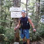
MZ1469 Duncan Hill N.H.
Best shot I took. Much better views but I wasn't thinking and didn't get any pics of them.

-
Spoo.
You got me going again with this topic. My knee is all better so I can start hunting again. Today wasn't the best of days on the hunt. I had 8 printed up but only got to look for 2 of them and didn't find either of them. MZ0262 had a wall of ice covering it and MZ1920 had a foot of snow over it. That usually doesn't create to much of a problem but under the snow I kept finding pieces of aluminum window frames and foam insulation. I probably dug 10-12 holes looking for things that the metal detector picked up. I had to have the sensitivity and discrimanation way up because of the depth of the snow so I got some bad signals. Nine hours and 200 miles with nothing to show but a good time.
Dave
-
I carry a long phillips head screwdriver to pin the end of the tape to the ground. You can pull the tape pretty tight that way. I also keep some bungee cords in the bag to wrap around trees, poles or posts to keep the end secure. It works like a charm.
-
Photobuff,
Since it is scaled, the discription is what you have to work with which states that the station is 28 feet west of the c/l of the road and 68 feet east of the east corner of the brick building. That looks like it would place the station about 60-70 feet north of the area where you were digging right between the building and the road. I would set up a point on each end of the building 68 feet east then I'd measure 28 feet from the road and see which end was the closest to the 28 foot mark. Then I would work on that area first with a metal detector and a probe. If I didn't find it there I'd use the detector 68 feet the whole length of the building. The 68 foot measurement would be the one to work off of since the road could have changed over the years.
Dave
-
Spoo,
Here's an old picture of the tools of the trade that I carry minus the food and hiking poles.
-
Spoo,
Your better off to get a fiberglass tape. The steel one's rust if you use them when it's raining or wet. I have both a hundred and a two hundred footer. I only carry one of them depending on the distance I have to tape.
Dave
-
Having just attended the benchmark hunting get together, I find that my GPS is an antique in that it doesn't have an internal compass that is automatically oriented to true-North. So perhaps there are many people that don't need to worry about declinations like I do.
ddnutzy - thanks for posting the map. I just like the calculation done for me even though it's very simple, it is one less thing to remember to calculate on site. A printout where it is already done would be nice. If your compass already compensates for true-North, the declination cell in the spreadsheet could remain zero.
Bdt
I have one compass that I always use with the declination set for the area I'm in. I trust the compass more than I trust the electronic compass on my gps 60cs. That thing will bounce around but the compass is always right.
If your looking for a bm that is buried under a hundred years of mulch and dirt and you have a reference from the corner of a wall that is 50 meters at 160 degrees and your declination is 15 degrees like it is in most of Ma. you'd better figure the declination in if you want to find the station. Quite a few of my finds have been found with information from an azimuth from a old stone fence or a big boulder near a 18 inch oak tree. The declination is quite important in situations like that.
Dave
-
Here's a copy of the declinations in the U.S. If your east of the zero or agonic line you subtract the declination from the compass bearing if your going from magnetic to true and you add the declination if going from true to magnetic. If your to the west of agonic you add from magnetic to true and subtract from true to magnetic.
Dave

-
I didn't get 200 of each in one day, but you knew that . The milestone of 200 finds of each was done on the same day. Two hundred in one day would have been one hell of a day I'd say. LOL
Dave
-
1. Both. I got 200 of each on the same day. Since then I've found 23 caches and 183 bm's.
2. I log both the Groundspeak and NGS sites
-

The bolt is the bound of Ma. and CT. It is also the highest point in Ct. that is on a mt. that peaks in Ma. (MZ2048)
-
Shirley,
I have always spent a lot of time in the outdoors, hiking, fishing, riding climbing, and I used to hunt. Benchmarking has given me another purpose for being in the outdoors. I usually do it alone as I'm retired and there are not to many retired people in my area who would spend the time required to hike or climb looking for the bm's I'm partial to.
Dave
-
.png) 1
1
-
.png)
Benchmark Picture Contest 2007 - Part 2
in Benchmarking
Posted
OC1354 Chococura 1876 w/ Mt Washington in the upper left corner. Taken 8-4-07 but i logged the BM in 2005.