


ddnutzy
-
Posts
153 -
Joined
-
Last visited
Posts posted by ddnutzy
-
-
Both of the emails I sent were refused and returned to me as if Deb was no longer there. I just sent another email to see if it happens again.
-
WHAT was a permanent situation?
I sent a destroyed station back at the beginning of the month, nothing yet, but that's usually normal.
-
Earlier this week I tried to email Deb with two destroyed stations and each time I got a email return message stating that this was a permanent situation or something like that. Any one else
have the same problem?
Dave
-
-
This is a picture of PG1684 (Camels Hump Reset 2 RM1) looking north towards Mt. Mansfield which is the highest mountain in Vermont. Camels Hump is the third highest. The haze is smoke from forest fires in Canada.
-
OD1328 in Vermont. I got this while hiking the Vermont Long trail. I forgot to bring the sheets so this one in the only one I found The station is in the center of the picture.
-
I've found quite a few BM's in the snow. I snowshoe in with my pack and a metal detector. If I can find a good take off point to measure from I do that then I clean off the snow and use the metal detector until I get a signal and go from there. Some of my finds are mz 1532, mz1533, mz1534, my3009 and my6397. Some off them had up to 18 inches of snow on them.
Dave
-
It all started with Manomet. Well actually maybe it's all Holograph's fault with his great web site on the EOA. And it could never have happened without the Internet and Google Books, and NOAA's publications.
What is it I'm talking about? A couple of weekend's ago I found and recovered a marvelous monument on the Massachusetts / New Hampshire boundary. It turns out to be the most important spot on the boundary whose location was determined in 1741 and is probably the most important and historic point in that area which happens to be known and visited by NO ONE AT ALL.
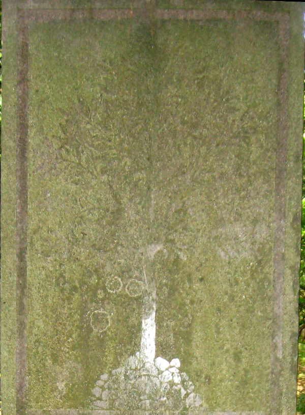
The Pine Tree (sorry it's hard to see - but notice the stones piled around its base)
Here's how I got there:
Summer 2007: a discussion on this forum introduced me to the Eastern Oblique Arc which is explained in Holograph's site above and in the 1902 report from the NOAA site. Being the history buff / benchmark hunter / compulsive list maker that I am, I said "Wouldn't it be cool to find all those 19th century marks".
Sept. 2007 - I go to Maine a nd New Brunswicjk and actually find a bunch of these marks.
April 2007 - A coincidence of a trip with the County High Pointers and benchmarking led me to meet up with Dave (ddnutzy) and together we found a bunch more of the EOA stations in Massachusetts (see this thread).
I was intrigued as to why a few of the stations in Massachusetts pre-dated the main survey that the Coast Survey did there by some 10 to 15 years (including Manomet). It was then I discovered and learned about Simeon Borden and his early survey of Massachusetts.
I did a bit of internet research and learned a little about Borden's "Trigonometrical Survey of Massachusetts" and NGS Surveyor was gracious to send me a copy, including Borden's Map (which, with some help from my Photoshop savvy son, I put up on-line here). I discovered that in addition to making the survey of Massachusetts, Borden also surveyed selected points on the border, one of which (Watatick) I found in July (see the last bit of this log including the last few photos). Apparently he set a few monuments such as that one, but on the whole he surveyed existing monuments and included their locations in his results.
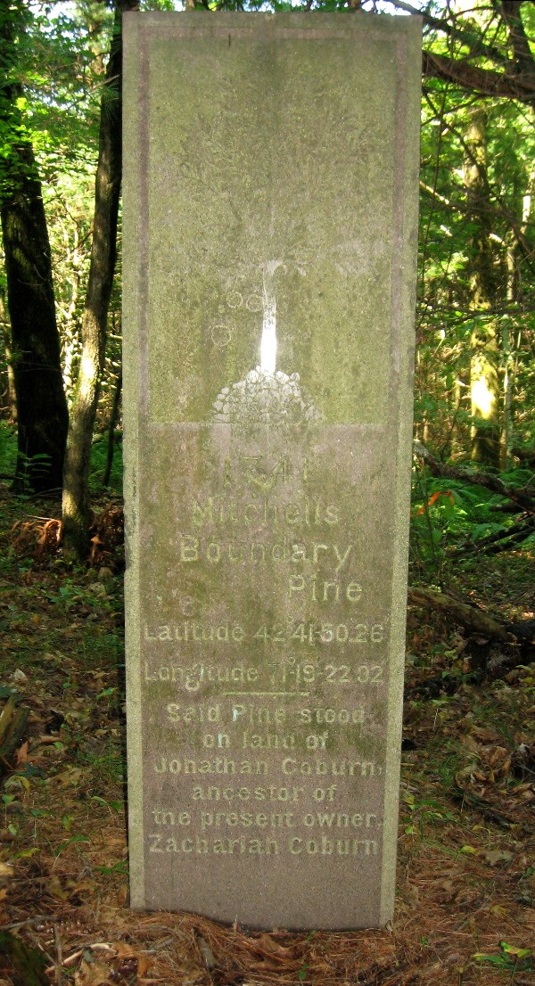
One was called "Pine Tree" and it was near the end of the east-west line of the New Hampshire border. a couple of weeks ago I was going near that area, so I figured out the location using the modern datum, and went and looked for it. Well (besides getting lost on the way back from my car), I found much more than I bargained for.
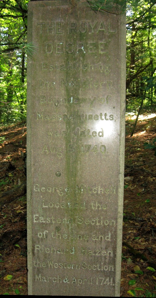
There was a monument with all kinds of dates on it: On one side was "1741" which included a picture of the original pine tree used when the line was first laid out. On the North and South sides under th "M" or "NH", were the dates 1825-27, when the line was first marked by stone monuments, and 1890, when the present monuments replaced the older ones. The another date (not engraved on the monument), was 1834 when Borden measured the location of the point (this date was given in C.G.S. Publication No. 76 "Triangulation in Massachusetts"). On the remaining (west) side was the date of the original Royal Decree (1740).
Here's the east side of the monument with the Pine Tree:
And here's the west side which dates the decree and gives the names of the surveyors (George Mitchell and Richard Hazan):
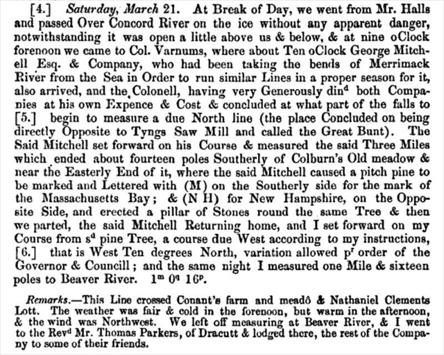
Now I was really, really intrigued. This was no ordinary state boundary marker. When I got home, I did some more research and discovered this was the actual Point of Beginning of the 1741 survey. It was originally called "Mitchell's Boundary Pine". I found the log of one of the original surveyors (Hazan) in an obscure genealogical journal and I quote:
So the history of this point can be traced as follows:
1740: Decree of king George II
1741: Mitchell and Hazan lay out the line statring at the pine tree.
1827: the line is remarked with rough stone monuments
1834: selected points are surveyed by Simeon Borden as part of his survey of Massachusetts
1890: the current monument were put in place, including this one.
The only monument with similar documentation on the stone itself is I think MY5214 - SALISBURY MARSH MONUMENT, which includes Borden's 1834 copper bolt and an 1890 marble monument with many of the same names of commissioners and surveyors as this monument.
As far as I have been able to discover, all the points surveyed by Borden made their way into the NGS data base, but many of them (including this one) are not published since the original descriptions were lost. This station has a PID of MY2668. I've entered a full description in my NGS recovery log, so hopefully in a month or so, you'll be able to read this sheet.
In the mean time I logged in here on GC under station MY2666 GUMPUS 1834 which is near by and which I also recovered the same day.
Here's my log for this station MY2668 - PINE TREE MONUMENT which includes all the photos and quotes from various decrees, surveys, &ct.
And here's a Google Map: Pine Tree Monument Google Map
Check it out. But if you are a boundary monument buff like me and decide to go and find it, do yourself a favor - take a waypoint at your car before you venture into the open woods for the short .3 miles trek to the stone. You might save your self the 4 mile walk back that I enjoyed on that hot day!
Richard,
I was impressed when we went out earlier in the year but now I'm amazed at what you do when searching for old benchmarks. This station is without a doubt the most intriguing benchmark that I've heard about. Keep up the interesting work. It's well worth reading about.
Dave
-
Since they each have different coordinates they can't be on the same disk. Skelton is at N46 30.318 W092 40.467 and 0980 is at N46 30.267 W092 40.483 .1 miles different. I have no idea what the problem was when they set them but I don't think that they are at the same location. I'd check the other coords and see what's there.
Dave
-
I've found quite a few benchmarks on Mountain tops around New England using the USGS paper description the box,highlighters.compass,100m tape and a metal detector plus the other tools in my bag.My only companions on these trips were Wildbird, probably 20 or so finds and Blackstone Val with 7 or so. All the rest were by myself.
Last weekend I had the privilege of spending two days looking for benchmarks with Papa Bear. The organization was amazing. All the stations and Rm's were laid out on Google Earth with the azimuths and distances in both feet and meters. He had all the USGS descriptions and the maps in the order that we were going to look for them. He also had Mapquest directions, or something like that from point to point so that it would be easy to get from one station to another.
All I can say is that it was a enjoyable weekend of benchmarking finding stations that were used in the surveying of Massachusetts in the 1800's. There's no way that I would ever have figured out how to do what Papa Bear did for that weekend.
Dave
-
You know your a benchmarker when you drive 226 miles one way to find two benchmarks ( PF1173 and PF1171) and do the climb up Caribow Mt. when there is lightning to the north, and it's coming south. It was a 3 mile climb up the mountain and it rained most of the way up.
At least I didn't go up Speckled Mt. to find that one. The storm really came along with high winds, thunder and lightning. I did go back at a later date and got PF1171.
-
Here's a list of the older BM's that I've found over the years. I've found over 30 from the 1800's. Most of them are FTF.
MZ1504 1832 oldest in Ma.
MZ1615 1832
MZ1702 1832
MY3617 1834 oldest in RI.
MY3611 1834
LW5088 1834
MY2666 1834 oldest in NH
MZ1913 1836 oldest in VT
OC2210 1842 oldest in ME
Dave
-

A USGS BM on Mt Liberty in NH. I think,but I'm not sure that the drillhole in the foreground is a RM. The figure in the background near the station is my hiking partner, Mr. Brigham.
-
It doesn't look like there is to much deterioration of the concrete because it looks like the disk is at the same elevation as the area where the chiseled square is supposed to be located. It could be under the leaves on the edge of the concrete. That looks like it's about 6 inches further north of the tracks.
Dave
-
Hi,
I'm up for a little benchmarking trip along to border. I've found a few in that area but there's got to be some new one's out there that I didn't find.
Dave
-

A 2003 Subaru Baja known as the Bajamobil is my ride of choice. I've taken it on old loggin roads,up mountains on said roads, through deep mud and over lots of rocks and ledges while looking for old bm's. The picture is on the way back from MZ1700 (High ridge) on 1-4-05.
-
John,
I have numerous map programs but the one that I use the most is Terrain Navigator Pro from Maptech I also use Terrain navigator. All of N.E. for the pro is $299.00 and the Navigator is $99.00 for N.E. The detail and ease of use is worth the cost.
With the pro the NGS bm's are on the map which makes it easy to find them on any quad.
Dave
-
Thanks to everyone who helped me on this subject. I have waymarked the disk under Mt Liberty.
Thanks again,
Dave
-
Yesterday I was hiking on Mt Liberty where I found a BM disk marked US Geological Survey, elevation, ET10DA, 1964. When I got home I couldn't find it in the Geocaching or Ngs database. I did a radial search with no results.
The elevation is 4459 feet and the coordinates are N44 06 57.62 W 071 38 33.01. I need help finding out what the pid of the station is.
Thanks,
Dave

-
I sent in one reply but it doesn't seem to be there. I use a Garmin c330 to find benchmarks. I mark the waypoints on my Mapsource Topo or my Maptech program and dowload them to my c330. It get me close by road then I use my Garmin 60csx for the rest of the trip.
Dave
Thanks for the reply. I do not have either of those programs. I have Map Send topo that came with my megellan. Guess I will find out . Thanks again
I think that the mapsend program will work like the mapsouce
-
From the page where you edit your cache description, click on the link to enter an "update coordinates" log. You can make a short hop of 90 feet all on your own.
Off topic, but in order to be complete in my answer: If you try moving your cache more than .1 miles, you will get an error message. For large jumps you need to contact your volunteer cache reviewer for assistance, and their answer may be to archive the old cache and create a new one..
Keystone,
Thanks for the info. The cache is now enabled wjth the new coordinates.
Thanks again,
Dave
-
I sent in one reply but it doesn't seem to be there. I use a Garmin c330 to find benchmarks. I mark the waypoints on my Mapsource Topo or my Maptech program and dowload them to my c330. It get me close by road then I use my Garmin 60csx for the rest of the trip.
Dave
-
I moved one of my caches (GCQRJQ) about 90-100 feet to the south of it's previous location and tried to change to coords on the file page. I could not change the original coords on the file. I emailed Groundspeak but did not get a reply. Does anyone know how to change the coordinates?
Thanks, Dave
-
OC1354 RM1 which I think is different.

Deb Brown
in Benchmarking
Posted
The problem seems to be resolved. I sent destroyed email to Deb and I think it got to her. I don't know what happened earlier but I think everything is alright now.