

NB2E-HAM
-
Posts
11 -
Joined
-
Last visited
Everything posted by NB2E-HAM
-
The process is a dye sublimation process. The tags are coated in a polyester coating and the image physically becomes part of the tag as the dye is subjected to heat and pressure in a specialty press. When the process is finished you have a polyester coated tag with the image / graphics work / tracking code embedded in the polyester. We've found that it holds up quite a bit better than the screen printing or direct-to-item printing method that is used by some other retailers. We make A LOT of photo dog tags for military members with photos of their families, etc and although they might scratch occasionally we've been told they hold up rather well during deployments to Afghanistan and Iraq. Although it would reduce the viewable area around the outside edge of the tag, one option if you want extra protection would be putting a "dog tag silencer" on the tag (this would only work on the standard military dogtag shaped ones). They're basically rubber bumpers that stretch around the edge of a military dog tag that have been traditionally used to prevent them from clinking together when worn. It wouldn't prevent surface scratches but it would make them less likely. We don't do engraving in-house, we shop our engraving out to a third party which would raise the cost. I'll look into that option also though. Thanks for your input, Ric
-
To clarify for the purposes of ensuring that I'm not breaking the forum rules; It is not my intention to solicit customers or business. I only want to know if there is a general interest by geocachers in a particular product. I work for a company that produces sublimated gift products and I have access to the equipment to produce sublimated goods after business hours with permission. If there's sufficient interest I'll contact geocaching.com's business development office to get signed up as a manufacturer. What I'm considering is: 1) Making customized dog tag shape trackable tags (same shape as a travel bug). The difference would be that I can do full color and even photographs. The tags would be trackable through geocaching.com. Tags could be two sided or one-sided. 2) Making "add-on" tags with only a tracking number and the required "Trackable on Geocaching.com" text. The tags would be 1.25" round tags with a hole intended to be attached to whatever item you want to travel around. 3) Doing dog-bone shaped tags, heart shaped tags and other shapes if requested. I won't discuss prices on the forums or in this thread. The only thing I really want to know (to keep this thread from getting locked / deleted) is... Would you be personally interested in custom tags if the pricing were on-par with the standard non-customized products offered on geocaching.com? Thanks! NB2E-HAM
-
What browser are you using? I noticed that I had the same issue on my phone using both Internet Explorer (mobile) and UC Browser. It also did the same on an iPhone 5. I ended up not being able to submit the cache until I got home and did so using Chrome which worked fine. Ric
-
Were you really close to the missile site? The theodolite pedestals I'm used to seeing at missile sites are within the gated area and usually located at one corner of the concrete pad on which are mounted the launch tube's doors. Some sites (depending on the missile family/type) had more than one. The theodolite (mostly Wild T-3's/T-3AM's, there's currently an ebay auction for one with -GREAT- pics located HERE) were used to align the missile in the launcher tube. Many of the older missiles used a gyroscopic targetting system that depended on the missile's pre-launch rotational orientation with magnetic north and it's known starting (launch) point in order to navigate along it's flight path to it's target. If youre interested in more of the details do a google search for "Missile Wild Theodolite" or register and do a search on the Missile Forums located HERE. Ric
-
Sign me up! Might be a newbie but I'll give it a shot. Unfortunately I'm in Upstate NY, hopefully the snow will clear out of the woods / mountains in time. Ric
-
Unpublished Field Notes / Descriptions of Historic Marks?
NB2E-HAM replied to NB2E-HAM's topic in Benchmarking
ArtMan & NGS Surveyor: Thanks for the heads up on where to look for more info! Ugh, What I wouldn't do for a 1:1 scale copy of that progress sketch. I stopped by the library in Watertown today and (after taking care of an 11 year old library fine) found a copy of Colvin's report to the state legislature from 1879. Unfortunately every plate in it was crumbled beyond recognition. I did scan the "Division of Levels" pages listing the benchmark location descriptions though. (http://bm.digi.imap.cc) Condition of Colvin's Report to the State Legislature at the Library: http://bm.digi.imap.cc/colvinreport.jpg I'm going to see if I can get the field notes on microfiche/film through interlibrary loan. Might take some work as the local library doesn't list the state archives as one of it's interlibrary loan sources. I'll find out tomorrow. There doesn't seem (from the description posted) to be much of a index to the film but it should be an interesting read anyway. If anyone else is looking for anything specific regarding Colvin or the Adirondack Survey let me know and I'll look once the film comes in. Ric -
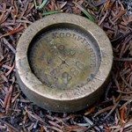
I'd like to visit and document as many of the remaining marks as possible that were set by Verplanck Colvin and his teams during the initial Adirondack Survey here in New York. I've been reading his annual reports to the state legislature from 1873 & 1879 which list some but not all of the marks set. The reports are a great read and it's obvious from his writings that he had a true passion for the Adirondacks and for his job. Some people even called it an obsession. There's alot of history behind this survey and the impact that this survey had. Verplanck Colvin was among those whose opinion and testimony to the state legislature later led to the preservation of the Adirondacks and the formation of the Adirondack Park Agency. Who would you contact if you were looking for information on historic benchmarks such as these? The marks themselves that I'm looking for don't bear the name of any particular agency but are brass/bronze ~2.5" disks set in drill holes. At the start of the survey he was appointed to the position of superintendent of the Adirondack survey by the state legislature and was given a $1000 budget, by the time the survey was complete he was the state superintendent of the new york state land survey. Who would you contact for more information on the benchmarks placed during the initial adirondack survey? The state? What department? I've noticed that at least one USGS mark description mentions an "Adirondack Survey" mark. What department or organization would still have copies of his field notes or the other years reports to the legislature? Anyone have any ideas or want to team up and tackle finding some of these marks? There are at least two styles that were set: Ric
-
Could you drop me a line when you plan on going back up, I'd love to tag along. I've taken a huge interest recently in the initial adirondack survey performed by Verplanck Colvin in the 1870's and from the sounds of the USGS datasheet one of his marks still remains. QUOTED FROM DATASHEET: "AN ADIRONDACK SURVEY DISK IS NNW OF THE STATION. IT IS A 2-INCH BRONZE DISK SET IN A DRILL HOLE FLUSH WITH THE SURFACE OF THE ROCK. IT IS BADLY DEFACED. POINT LOCATED WAS THE APPROXIMATE CENTER OF THE DISK." I'm not absolutely certain this is one of the disks set by one of Colvin's teams but it sounds appropriate. I only have two years worth of his annual reports to the legislature detailing his progress (1874 & 1879). Neither of these reports mentions Mt. Morris, although it is possible it was named or renamed after his reports to the state or that it is listed in one of the yearly reports I don't have. If anyone makes it up Morris before I do, here's a pic of what the disk would have roughly looked like when it was set. Ric Edited to add: Sorry for resurrecting an old post, I couldn't help myself ;-)