indygpser
-
Posts
56 -
Joined
-
Last visited
Posts posted by indygpser
-
-
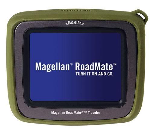
Below is a photo of the 2500T. The unit seems to be about the same size as a Garmin 350/360. This may be a little too large for my outdoor navigation needs.

-
One repeated thing I've read in reviews regarding using the GPSMAP 60csx is that the warning signal for turns is kind of short. Maybe someone with one can confirm or contest that.
The 60CSx is a fine GPSr for navigation on the roads. I haven't seen any problem with the warning signals for turns on the 60CSx. As a matter of fact, I also own the Nuvi 350 and the 60CSx performs just as well as the Nuvi on the roads.
-
Why is this thread entitled Mapsource Topo 6.11.1? It is a little deceiving, don't you think? This update has nothing to do with updating Garmin's Topo USA software.
NO, It's not deceiving......It's just that YOU don't understand....there is Mapsource Topo, Mapsource Metroguide, Mapsource City Select, Mapsource City Navigator, Mapsource (etc,etc.......)
My original Mapsource program CDs, that the above posted update applies to, say Mapsource Topo.
I guess you could be confused with the word TOPO enclosed. Yes it is the MapSource program itself being updated with update 6.11.3 now which I have updated. The actual MapSource TOPO USA is version 3.02 which I have but basically its all a MapSource program you have to access to use TOPO USA. I didn't mean to deceive anyone but I figured the information submitted regarding this issue was self-explanatory.
That's OK...no problem. Perhaps Grasscatcher will now understand why I made my comment.

-
Why is this thread entitled Mapsource Topo 6.11.1? It is a little deceiving, don't you think? This update has nothing to do with updating Garmin's Topo USA software.
-
-
If I forget to turn it off, will the backlight fail (burn out) over a period of time?
Well, over a long period of time, yes, but we are talking about 11.41 years. The LED backlight is rated for 100,000 hours for all Garmin units. This equates to 11.41 years of continuous use. Therefore, it would be very rare for an LED to fail. I've never had a backlight burn out in any electronic device I have ever owned.
-
I hope not. That would be one to put on the Ignore List.
You guys are too funny.

-
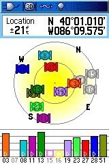
This screenshot was taken while in my home and inside an interior bathroom with no windows. Awesome reception/sensitivity and still pulling in WAAS. Amazing.

-
Since updating my 60CSX w/2.60, I now can lock onto #35, #48 and #51 here in Indianapolis. All three display a solid signal bar. #51 is most commony seen, followed by #48, then #35. Yesterday, I was sitting in my car (2005 Saab 9-3 SS) in a parking lot and I was locked onto #51 w/11 other satellites showing stong signal bars and "d's" and the EPE was 8-9 ft. for about 1 hour. During this time, my 60CSX was mounted on a vent mount with the 60CSx antenna located about 2 in. below the top of the dash. Darn good performance, if you ask me and without an external antenna

-
I love my 60CSx! IMO, the 60CSx is the BEST handheld GPSr available at this time. Now, that will stand until Garmin (notice I didn't mention Magellan or Lowrance?) releases the next best GPSr available.
-
I updated my 60 CSx to 2.6 and I now see #48 and #51 from the Indianapolis area...primarily #51 and with d's showing. Also, the signals are very strong and I can receive WAAS indoors, as well.
On a side note, I also updated my Nuvi 350 and sure enough, I am now receiving #48 and #51...primarily #51 as in the 60CSx. However, the signal bar for the WAAS satellite remains hollow and the satellite blinks off and on. I wonder why this is the case? Any answers?
There in test mode. They won't be up and running until the fall.
I understand the satellites are in test mode. However, this is my situation. I tested my 60 CSx and Nuvi 350 side-by-side this morning. Both units were receiving signals from #51; however, the 60 showed the #51 signal as a solid bar and with d's showing on the other birds, the 350 showed #51 as a hollow bar, blinking on and off and with no d's showing on the other birds. The 60 and 350 use the same Sirf III chipset. Therefore, I would think both units would behave the same. My question is why is the 350 showing a hollow signal bar for #51 and with no d's showing on the other birds?
-
I updated my 60 CSx to 2.6 and I now see #48 and #51 from the Indianapolis area...primarily #51 and with d's showing. Also, the signals are very strong and I can receive WAAS indoors, as well.
On a side note, I also updated my Nuvi 350 and sure enough, I am now receiving #48 and #51...primarily #51 as in the 60CSx. However, the signal bar for the WAAS satellite remains hollow, no d's showing and the satellite blinks off and on. I wonder why this is the case? Any answers?
-
I own both the 60CSx and the Nuvi 350. Regarding autorouting, the 60 is every bit as good as the 350. As a matter of fact, I have tested both units, side by side while on the road and 99% of the time, both units calculate the exact route.
-
I work in the environmental remediation field. GIS plays key a role in our field starting from the initial subsurface investigation and on to the engineering/corrective action phase and ending with the remediation of a contaminated site, property or area.
-
OK, if I have a mapset saved on my PC and all I want to do is to add one map section to my mapset. The question I have is how do I upload the one map section to my 60CSx without the whole mapset being erased on my GPSr and then all maps are uploaded to the unit (which is very time consuming). What am I missing here?
-
I've said it a hundred times...I just don't understand how a person can spend $400 on a GPSr and not spend another $20.00 for a protective case. It just baffles me.
-
Count me in as a very satisfied 60CSx customer. I use mine primarily for hiking and biking and the CSx is a great performer. I have also tested my CSx side-by-side against my Nuvi 350 in my car and was very surprised to discover the CSx is just as good as the Nuvi when routing and navigating on the roads.
-
A couple of months ago, I sold my 76CS and some accessories on eBay for $331.56. The 76CS was also nearly 2 years old; however, it was also in very good condition.
http://cgi.ebay.com/ws/eBayISAPI.dll?ViewI...item=9707866772
-
My StreetPilot c550 has a SiRFstar III receiver. According to Garmin, it can't show any "D" symbols, since SiRF uses the data differently, compared to Garmin, hence there's no knowledge about when to display the "D".
What says SiRF is different in the 60CSX?
Not to get off-topic, but how do you like your c550? How is the integrated traffic receiver? How is the bluetooth? I'm thinking of selling my Nuvi 350 and purchasing a c550.
-
It's possible the data is corrupted and causing the program to fail.
I received my elevation data from http://seamless.usgs.gov/. I can open the .img file in GPSMapEdit and I can see the contour lines for Brown County in accordance to my specified intervals and zoom levels. Can I assume that because everything seems to be working fine in GPSMapEdit that the file is not corrupt?
I also appreciate your comments and I will try some of your things. Additionally, thanks to everyone else for responding to my questions. I am a newby at making maps; however, I am definately intrigued by the process and I am sure I will find some personal satisfaction in creating my own detailed topo maps.
-
The only thing I can think of is its overheating. Raise the laptop off your desk. How big of an area are you trying to convert?
I'll try raising the computer off of the desk. I am tgrying to convert Brown County, Indiana.
-
I decided to load all of the software to make topo maps on my notebook computer. I mave a Dell Inspiron 5150, 512 mb RAM, 3.2 Ghz P4 processer and Windows XP Professional. I am having a problem, though. When I am converting the .tiff file to .mp in Dem2Topo, the computer shuts off (powering off) suddenly after about 2 minutes after the conversion process has began. Any suggestions? Thanks.
-
Under the view menu you can force it to show what is in each level.
I think I remember getting that error, but I don't remember how I fixed it.

If you do remember how to fix the problem, I would HIGHLY appreciate the solution. This is very fustrating. Thanks.
-
Sorry, my highest level is level 4, which is empty and as I stated above, Level 3 has just a small line in it.

Explorist 500 or Garmin 60CSx?
in GPS technology and devices
Posted
If you are a member of Costco, you can pick up the 500 for $179.99 online including S & H.
http://www.costco.com/Browse/Product.aspx?...ome&topnav=