

Dr Jeckyl and Mr Hide
-
Posts
807 -
Joined
-
Last visited
Posts posted by Dr Jeckyl and Mr Hide
-
-
The manual for the VIRB Elite can be downloaded here (http://support.garmin.com/support/manuals/manuals.htm?partNo=010-01088-10).
I have the Elite and have been having issues with it connecting to the satellites. I've tried everything from resetting the battery, resetting the unit and walking out into an open field with a complete open view to the sky and no dice. It will not connect! I've emailed Gamin support, just waiting for a reply. I hope they come out with software updates.
Has anyone had an issue connecting to the satellites?
Mine does lose the sats occasionally in treed areas. But it is connected most of the time.
When did you buy yours?
I bought mine from http://www.thegpsstore.com/
How about you, where did you purchase yours?
I bought mine from GPSCity, but I was more interested in when you bought yours.
-
The manual for the VIRB Elite can be downloaded here (http://support.garmin.com/support/manuals/manuals.htm?partNo=010-01088-10).
I have the Elite and have been having issues with it connecting to the satellites. I've tried everything from resetting the battery, resetting the unit and walking out into an open field with a complete open view to the sky and no dice. It will not connect! I've emailed Gamin support, just waiting for a reply. I hope they come out with software updates.
Has anyone had an issue connecting to the satellites?
Mine does lose the sats occasionally in treed areas. But it is connected most of the time.
When did you buy yours?
I'm interested in getting it to do time zones right for me. It has me 1 hour ahead unless I set the time zone manually.
-
My Elite arrived with documentation for the basic model. I've asked Garmin through their online form for a manual for the Elite model. Would be interesting to know if there is one right now.
To answer my own question above: The online PDF manual has info on the Elite model buried inside, where appropriate.
What a great little device!
These Dashboards show what the gps can do, aside from Geolocating photos and video. I especially like the G Force display!

(Screen capture from the Garmin VIRB manual)
-
I am very surprised that no one mentions an external antenna.The 60's series can use one,so can 76 series.My wife and I hike all the national forests and believe me,the external antenna is a must for drawing in the sats signals.Try one and you will see for yourself.They are relatively inexpensive,we use gillson antennas,but,there are others.Many gpsr's don't have the connection and that is unfortunate.
The 62/78 and Montana also have external antenna connectors. We used the connector on my wife's Montana when her internal antenna broke off the circuit board.
-
My Elite arrived with documentation for the basic model. I've asked Garmin through their online form for a manual for the Elite model. Would be interesting to know if there is one right now.
-
Just got my new VIRB Elite yesterday and haven't had much time to check it out yet, but the first thing it wanted to do when I turned it on, after the Language selection, was find satellites to get a gps fix. It only took about 30 seconds to find itself, so it's now ready to geolocate pictures and video.
Anyone else have one out there and willing to share their observations?
-
Doesn't really matter, as long as it can pull up caches live, say with 3G, as the Kindle can do with books.. Oh wait..
It can if you tether it to a phone.
Yes, but I don't have a smart phone. This unit would serve a purpose if it had 3G and behaved like a Kindle, just tailored for GPS instead of books.
Find a WiFi hot spot? They are easy to find.
-
Doesn't really matter, as long as it can pull up caches live, say with 3G, as the Kindle can do with books.. Oh wait..
It can if you tether it to a phone.
-
I love how both you acted like I said NOBODY or EVERYONE...I said those are the types that tend to buy these units anymore. Geocaching is fun and all, but personally I have only come across 2 other families that have ever heard of it. So sure there are some people that buy for just geocaching as well, but again this is a minority of the general population. See the difference? I would use my Colorado if I was really going off the beaten path for sure, but there are times when you would have your phone and not your handheld is the point, so having these apps would be great. Note I said nothing about NOT buying these units or the new Monterra, I simply said the apps would be a huge benefit.
The way I use the English language, "only hikers and hunters really buy a stand alone handheld unit anymore" means "nobody but hikers and hunters really buy a stand alone handheld unit anymore." Same difference.
Almost all of my geocaching involves going off the beaten path. Places where there is little or no cell coverage. Places where tree cover makes the GPS in most cell phones mostly ineffective. Therefore, almost all of my geocaching is best done with a dedicated unit, whether or not some new Android offline mapping app comes along.
--Larry
Same here. If someone says something I have to assume they mean what they say.
I hardly do any Geocaching anymore so there's no need to assume that's why I own so many dedicated gps units. But having used my iPhone on a couple of occasions to navigate, I know enough to make sure I always have a real, dedicated gps with me.
There's nothing quite so annoying as to be using a phone as a gps or music player, or any of the hundreds of other things it'll do, and to find out that its battery is dead and you can't use it for its original purpose. Especially in an emergency.
-
everyone has a phone and only hikers and hunters really buy a stand alone handheld unit anymore.
That's news to me. I wouldn't dream of using my iPhone as a gps. It gets too hot if powered, and the battery only lasts a couple of hours. Long enough to get lost but not long enough to get back.
-
Has anyone had a problem with the Garmin Oregon 600 coming off its bike mount? I have two bike mounts on two separate bikes and the unit has jumped off both, both times when I hit a pothole. I'm not happy about this and am thinking of taking it back. Any help?
I never had a problem with my Garmin Rugged Mount on a RAM base.
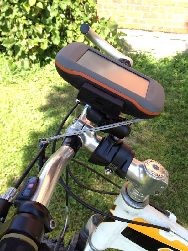
Edit: Sorry, you said Oregon, I read Montana. Different, obviously. My bad.
-
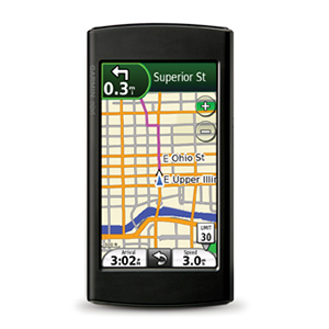
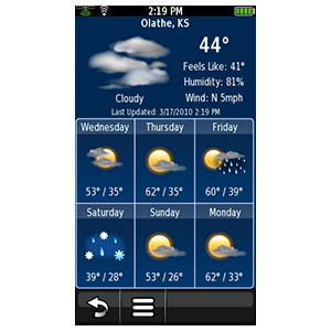
Now if Garmin comes out with a WiFi enabled, smartphone-esque GPSr... that's a total game changer. I'll throw my money at them faster than an Apple fanboy on iPhone release day... I hope I didn't say that too loud.

Just like the Nuviphone!
How quickly we forgot the 295W... We still have one, but they are hard to find now. Garmin was practically giving them away when they discontinued them.
-
I'm surprised nobody's mentioned the data fields bug on version 4.40 here. If you touch the menu button on the map screen when using the data fields dashboard, the gps shuts down. I'm still running 4.40 anyway, since that's the only bug I've found and I can avoid it.
-
You do not have to download an Adventure for this to happen, I didn't.
But you do have to have at least one Adventure on your gps for the "Adventure" category to be added to the "Where To" element.
-
I'm guessing that no one has had any issues with this release.

Anyone having any problems? I am waiting for my new uSD card to arrive before updating.
Haven't heard of any problems except for one guy on Facebook who reported a Birdseye problem with his, which cleared up once he'd reformatted his uSD card and reinstalled his Birdseye maps.
-
GPSMAP 62/78 (WebUpdater) software version 4.20
http://www8.garmin.com/support/download_details.jsp?id=4995
Changes made from version 3.90 to 4.20:
Added ability to sort waypoints alphabetically
Has anyone actually confirmed that this "sort" facility is in their gps now? I upgraded to 4.20, confirmed it in Setup/About, but I do not see any Sort command anywhere in "Waypoint Manager" or "Where To/Waypoints". It is on my Montana, but not my 62S.
-
Garmin Montana Version 4.20
Changes from version 4.10 to version 4.20:
Added ability to sort waypoints alphabetically
Improved search speed in Where To? menus
Fixed review of individual route points through the Route Planner
Fixed issue with the Glide Ratio data field
Fixed occasional map display issue when using Topo Deutschland 2012 Pro or Garmin TransAlpin 2012 Pro
-
Duh. Sorry but I can't change the subject or delete it. Grr.
Garmin Montana Version 4.20
Changes from version 4.10 to version 4.20:
Added ability to sort waypoints alphabetically
Improved search speed in Where To? menus
Fixed review of individual route points through the Route Planner
Fixed issue with the Glide Ratio data field
Fixed occasional map display issue when using Topo Deutschland 2012 Pro or Garmin TransAlpin 2012 Pro
-
Good tips above.
In the settings for Tracks, you might want to set it to Auto Archive Daily if you are traveling long distances daily.
If you are traveling across many time zones, you might want to set your camera's time to UTC, time and date. Track logs record in UTC, so you will not have to remember the offset in the tagging program you use.
What does that do? I'll be covering 5 countries in 17 days.
It will break up your track into daily pieces. You may want to geotag your photos by the day's travel and embed them into the track log in a KML file. Depending on how many time zones you travel through, you might want to set your GPSr to UTC especially if you are near Europe. Use the Western Europe time zone with no Daylight savings time for UTC. Then you can use your GPSr time to sync your camera's time.
For your track log interval, I would not use one second. It is not necessary and will make the logs too big. Use Auto, Most Often. Try it before you leave. And if you are new to tagging, use GPicSync. It works well and is much simpler.
Storage space is cheap these days so I'm not worried. I'm still somewhat confused by this. Fortunately I brought my Garmin 60CSX with me so I used that. I just couldn't rely exclusively on the 62S while I was still learning the device.
Let's put it like this, can you tell me how to setup my 62S to be like my 60CSX? I want the tracklog to track every single second and to create new tracks on a daily basis. I do setup my camera to UTC time to make the matching process much easier.
After this is all said and done, how do I transfer the tracks from my 62S to the PC?
If you want to setup your 62 like your 60, go to Setup/Profile Change and choose "Classic". That gives you the 60 style screens.
While you can set up tracking to record every second, it's not usually a good idea. I suggest you set the following: Setup/Tracks, Record Method "Auto", Recording Interval "Normal" and Auto Archive to "Daily".
-
I'm surprised nobody seems to have mentioned this up to now...
GPSMAP 62/78 software version 4.03 Beta
as of May 18, 2012
Download (4.48 MB)
View installation instructions and system requirements
Notes:
Although this software is believed to be reliable, it has not yet been released for production and should be used at your own risk.
Change History
Changes made from version 3.90 to 4.03:
Added new route activity types
Added support for Kenwood NMEA Waypoint Sentence
Improved GPS response at low speeds
Fixed issue with preserving routes imported from Basecamp (identical maps required)
Fixed Spell Search in German
Problems with this beta software may be reported to 62-78Beta@garmin.com
-
Sounds great, can't wait to try it!
I'd wait, if I was you. I sent this to the Beta team this morning:
I played around with my Montana this morning and it looks to me like map selections are not saved in the different profiles, so each time you change profiles, you need to set the maps you want in that profile.
In other words, a selection of maps will be enabled, but not the choice I wanted.
I have multiple map selection based profiles, quickly accessed via shortcuts so it's very obvious that the maps are not the right ones in the profiles.
I tried many times to reset the maps to my selections then switching profiles but it always reverted to the wrong maps. This also happens if I use "Change Profile" instead of the shortcut to switch.
I don't remember seeing this in 3.98 so that's where I'm headed.
3.98 has the same problem, which 3.99 was supposed to have addressed according to this from the Change Log: Fixed issues with map set selections across Profiles
-
What version is your firmware? I've had persistent power cycle problems with the cradle in the past (white crash screen, failure to boot up). I have used my unit in the cradle using the latest round of beta's (versions not yet released via web-updater) and operation seems pretty smooth. I forget if others having problems (and I know there are some) have seen them go away in the latest beta versions. Anyone confirm?
I haven't seen a white screen in weeks now - running the latest beta, 3.97 on my Montana, and the latest web updater version on my wife's 650. Power source we use is the Rugged Mount on motorcycles and the Powered Dash Mount in the car.
Thanks for the tip, I just installed 3.97 beta and I'll give it a shot this week to see how it responds. Hopefully I'll have the same results as you.
Just make sure if you do see a white screen, take all power cables off, or take the Montana off its cradle if you're using one, and hold the power button in for 20 seconds to shut it down properly. If you take the battery out to shut it down, you'll probably continue to see the white screen more often.
-
What version is your firmware? I've had persistent power cycle problems with the cradle in the past (white crash screen, failure to boot up). I have used my unit in the cradle using the latest round of beta's (versions not yet released via web-updater) and operation seems pretty smooth. I forget if others having problems (and I know there are some) have seen them go away in the latest beta versions. Anyone confirm?
I haven't seen a white screen in weeks now - running the latest beta, 3.97 on my Montana, and the latest web updater version on my wife's 650. Power source we use is the Rugged Mount on motorcycles and the Powered Dash Mount in the car.
-
I use GMapTool to rename non-Garmin maps.
This forum has a thread by the GMapTool author which describes it: http://forum.openstreetmap.org/viewtopic.php?id=11417
Don't bother doing a Google search for GMapTool - you'll end up on a lot of unrelated sites which do nothing but force you to sign up for things you don't need or want.
I'm not going to lie, I read that entire thread twice now and it doesn't make any sense to me. It appears that GMapTool has a DOS or Unix style command line area where you have to insert -l or -j in order to get it to create the type of file you want/need. Is there some sort of an easy command that can just take my previously created whatever.img file and give it a name that a Garmin GPSr will display?
It may have a DOS/Unix style command line version but I use the GUI version. Here's a screen shot I made while renaming some maps:
At its most simple, all you need to do is add a check in the "Mapset" box and give it a name, then write it. (Make sure you have backups and don't write to a map which is actually in your gps at the time, just in case.)
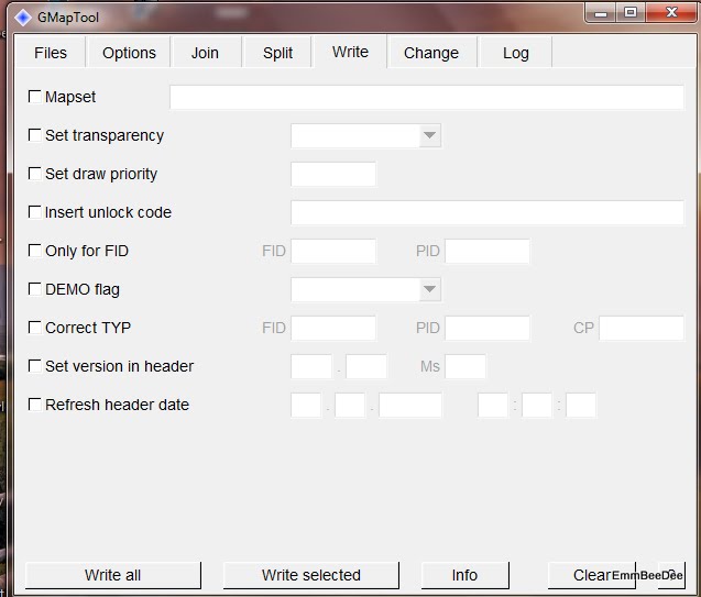
Did you click the word "Website" under his user name to get to the programs? Even though a lot of the programs are Polish, the GMapTool is English.


Garmin VIRB Elite
in GPS technology and devices
Posted
There don't seem to be many out yet.
How do you like yours? Is this your first camera of this type? I have a GoPro2 with WiFi back and getting great pictures and video out of that was so difficult.