


jonboy
-
Posts
400 -
Joined
-
Last visited
Posts posted by jonboy
-
-
I have exactly the same problem trying to calibrate the electronic compass on a GPSMAP 62s. I sent my first one back and got a refurbished one that also would fail to calibrate on the third step. I raised a fuss and they sent me a new unit, but it also failed to calibrate in exactly the same manner. By this point I had been fighting the issue for a month, and I basically gave up. I am hoping maybe they will fix the issue with a software update, but I am sick of banging my head against a brick wall.
-
I made the upgrade to the GPSMAP62s early this June and I have had a lot of problems with the electronic compass, specifically getting it to calibrate. I after failing to fix the problem after a week of frustration, I sent it back to Garmin for replacement, with a $12 dollar shipping charge. I received a refurbished model that was worse than the one I returned, it had the very same problem, plus a few other software issues. I am in contact with Garmin now and am hoping they do not send another returned lemon.
As far as the other features of the unit, the GPS itself is not any more accurate, but the paperless caching feature is very nice, and loads automatically from GSAK with a Premium membership. This is my 5th Garmin GPS and I have never struggled so much with the interface, I seem to spend much of my time studying tutorials and reading forum posts, and after three weeks I can't say I have fully mastered the system. I am not a novice and it should not be so hard, and my best guidance has come from third party sources, not Garmin itself.
-
Thanks for the tip. In answer to my own question, you begin navigation using the find button to get to the geocaching screen there, this is where you go to stop navigation. However, if you want cache information, to log your find or the hint, you must find the geocaching screen from the main menu. Why you cannot perform all operations from one screen is beyond me.
-
I have just upgraded to a GPSMAP 62s, I am trying to send a hint to my GPS using GSAK. I transferred the cache information to my receiver using pocket queries with no problem, but could not access the hint. There is almost certainly a macro to do this, but these are a little complex for me. I would appreciate any help.
Thanks.
-
I just noticed that Walkin' Ed made his 7,000th find on my new cache, Foul Ball http://www.geocaching.com/seek/cache_details.aspx?guid=0ca0448c-8d81-4459-b564-38e88ecba1bd
Congratulations Ed! I remember when I put a cache out in winter on the Timp and Ed ran up there in jeans and T-shirt to make the FTF. Hell, I remember when I had more caches than Ed, but that was about ten years ago.
Way to go Walkin' Ed!
-
I just received the new TOPO US 24K Northeast DVD for $99 from www.offroute.com. In addition to the added detail of a 24K map, just as important to me was the updated road and trail data. The trail data is by no means complete, but at least the AT route seems up to date. The road data is very useful, I was always switching back and forth from City Navigator to see the newer roads not shown on the topos. This seems to me to be a good value, Wi.,Mi., Ill., Ind., Oh., Pa., NJ, NY, Conn., RI, Ma., NH and Maine complete state coverage. I loaded NJ, half of NY, Conn, Western Mass, Vermont and Northern NH onto a 2GB micro chip, and only used about half of the space. The disc comes with new software that made the loading faster, I finished in about 40 minutes. I bought some 2GB micro chips cheap on amazon, everyone wants the new 16 GB chips.
-
Thanks for the help, I was looking at the screen at night, and a black background is the setting for night, my old 76S did not have that feature. Once I changed from auto to daytime, I saw my map screen in normal mode.
-
I purchased a 76CSx last week and I find that the background color on the map screen is black. I have this black background both on the basemaps and the older TOPO USA maps I have loaded. I haven't seen this on other units, and wonder if this is an attempt to remedy the problem of dim screens I have read about here. I am not sure whether I like this, but I have not been able to find any way to alter this background color so as to compare. It does seem that the smaller lines are more visible, but I like my map to look more like a traditional map. Has anyone else encountered this? Does anyone here know away to modify this background color?
Thanks.
-
Quoddy,
I hiked from the Canadian Border to Rogers Pass in August of 1988. In our nine day hike through Glacier, it snowed on us seven days. Resupply was difficult going through the Bob Marshall Wilderness/ Scapegoat Wilderness, as we went for 17 days without crossing a road. We left a resupply package at the Benchmark Ranger Station, in a special bear-proof storage cabin, but we had to drive in to place it.
I think you will definitely run into snow if you start in June, it doesn't clear out till late July. I did a trip in early July in the Wind River Range, and we experienced thigh deep melting snow, interspersed with heavy mud, topped off with clouds of bugs. The biggest problem you will have is not the snow itself, but the flooded river crossings during snow melt. Outside of Glacier N.P., you can expect no bridges. There were times when I had to camp at a river crossing and make the crossing at dawn, when there was minimal snow melt. The lingering snow under the trees caused us to lose the trail repeatedly, and we traveled at about half the pace that we had planned.
E-mail me privately if you would like to discus the trip further.
jonboy (John)
-
Congratulations on a great article Bernd. I was an AT corridor back in the 80's, in Putnam County, before we had accurate GPS units widely available. Our corridor had recently been surveyed for the land purchases, so we did not have to dig to find the AT Monuments.
It is interesting that you have been assigned the Nuclear Lake section. I was on the Putnam-Dutchess AT Management Committee back when this land was incorporated into the AT, it was quite a story, you can read about it here:
http://select.nytimes.com/gst/abstract.htm...or%20Department
but you would have to pay an archive fee. Nuclear Lake was the site of a plutonium processing plant, and there was a major spill of radioactive material in 1972 into the lake. There were also unconfirmed reports from former employees, of drums of radioactive waste being deliberately dumped into the lake. The company went belly up, and instead of having to clean up the mess, it was sold to the NPS for several million dollars, in one of those highly dubious sweetheart deals to which Washington is prone. When the public got word of all this, they were assured that the Nuclear Regulatory Commission had declared the site to be fully cleaned up. Anti-nuclear activists made independent tests and discovered remaining "hot spots"of radioactivity. The site was worked on and declared safe once again, only to have more "hot spots" found by the anti-nuke crowd. In the end, after spending far more than the purchase price in tax payer money, the site was more or less cleaned up, with only slightly elevated levels of background radiation detectable. At first the trail was routed far away from the lake, but eventually the public forgot, the activists found other causes, and the trail was routed next to the lake. I have gone swimming in this lake, and the best place to swim is at the clearing that was once the site of the nuclear plant. I would not eat fish caught in this lake, but plenty of others do.
-
One thing to bear in mind is that a GPSr purchased here will come with American Basemaps.
You will have to buy European software at European prices. This mapping software for the Netherlands Dutch Topos is 135 euros (about $250). or City Navigator Europe Europe for $299. Maybe you can find a better deal at home, but you will be spending some more money. Good Luck.
-
There is this one from Bergen County Parks:
-
I just had my four year old, badly dinged up GPS76S returned from repair, free repair I might add, to find that they had given me a new unit. I had broken a spring in the battery compartment. This is the second time they have replaced my unit free of charge. The first time I had broken the plug for the external antenna, about two years ago. They have made me one very satisfied customer and I wouldn't even consider buying from another manufacturer. Their products are cutting edge, with frequent software upgrades, the mapping software is superior, and this kind of support is amazing. They have discontinued making my model, so this may well be my last free replacement, but I definitely got my money's worth.
-
The Black Rock Forest trails are on the West Hudson Map Set. To reach the main parking lot, turn right off of northbound 9W at Mountain Road (just downhill from the pullover at Stormking). Immediately after you get on this road, make a sharp right into a narrow tunnel which goes under 9W. Follow this road to a junction, go straight 1/4 of a mile to a parking lot on the right. When leaving, make a left at the afore mentioned junction and drive up to the southbound ramp for 9W.
-
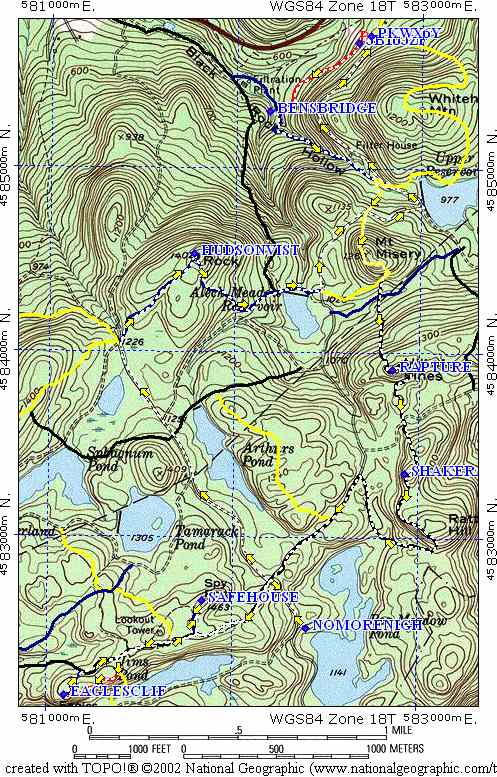
I just did Brian's Loop, now let me plug another Hudson Highland Loop, this one involving seven caches, in Black Rock Forest
No More Nights in the Alley Cache
http://img.geocaching.com/cache/c6902819-c...5bd2c8c89e9.jpg
This is about ten miles, if you do all the caches.
-
Poohstickz just set up a great loop in the Hudson Highlands, in Hubbard Perkins Conservation Area, in Fahnestock.
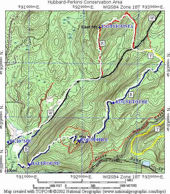
I highly recommend it.
jonboy
-
I have just started using a Gilsson External Amplified Antenna with my Garmin 76S, and while I am picking up many more satellites, it appears to be less accurate. When I download my track to a my TOPO mapping program, the track seems to deviate slightly from the route I actually walked. Also, when I obtain a new set of ten coordinates for my caches, the averaged result seems to differ significantly from those I obtained with just the unit. I used an external antenna several years ago to try and get more accurate coordinates for my caches, and other cachers compained my coordinates were off. Does anyone have any idea why this might be happening?
-
That was sound advice from Mopar, so far I have taken no action, other than ask for advice from this forum. In studying the logs further, I do note that most of them were logged on the same day as "Doghair Duo", and "Doghair Duo" mentions using four GPSrs for a find in one of their logs. If you are going to log multiple false finds, why stop at such a low number? It well could be that I have unfairly maligned a cacher. I am loath to approach a cacher with an accusation I cannot prove. I don't know why I should let it bother me, I haven't even been that obsessed with geocaching as of late.
-
My suspected bogus cache finder, "V&JP" is still at it. I finally figured out why I can't find his logs, he is backdating them months and in at least one case years. The most blatant one http://www.geocaching.com/seek/log.aspx?LU...54-4d6e7bf13143
was logged as a find dated over a year before he became a member and logged more than two years later. I know I can just delete this cachers finds, but how do I go about bringing this to the attention of Groundspeak?
-
Hi Avroair!
I still lurk around occasionally, I seem to spend more time maintaining my existing caches than finding new ones.
Given that the cacher in question still has an account, it could be that they deleted the questionable logs themselves. The cacher looks like they have some legitimate finds, their last activity was the day after the "finds" in question were posted, this may have been a deletion of the "finds" posted the previous day. My question is would Groundspeak be able to pick up on this kind of suspicious activity without a heads up from the cache owner? Perhaps he logged "finds" on other caches that day and one of the other owners raised questions.
-
I had eight logs for my caches in one day by a cacher called V&JP, each entry only saying "TNLN". I was sceptical, as my caches are not very easy and these were far apart, but I did nothing. Your raising this subject caused me to look for these entries, but they have all been deleted from my cache logs. I still have the messages in my deleted items folder in my mail box, but someone other than myself deleted them from the website. Does someone at Groundspeak monitor for this kind of suspicious activity? V&JP's profile is still active, but all reference to this cachers alleged very busy day on 10/8/06 are gone.
-
I got an e-mail from Andrea Gutman at Rockefeller State Park, saying that my cache (Butternut) was on NY State Park land and needed a permit and would be otherwise removed . This cache was previously on Greenrock Corporation Land (a Rockefeller Land Trust) but now seems to be administered by the state park. The previous person who had issued permits had left and they had no record of who had permits in the park. She also knew very little about geocaching or the permit process, and I found myself in the strange position of explaining the permit process to her and giving her a online link to LIGOs permit form. I also gave her a link to the NYgeocacher site. I had lost my permit application for Hearth on Hudson in Rockwood Hall and Long and Winding Road, so I filled out two more. On the plus side, it now seems that geocaching is to be permitted throughout the park. Also, I doubt she would have enough knowledge or time to go out and find the other caches. She is not even sure how many are in the park, she has no mapping program and is only a part time employee. However, the admittedly creaky wheels of State Park bureaucracy seem to be trying to move. I know others disagree with me, but I favor cooperation to resistance. Right now Andrea has a positive impression of Geocachers, it should not be too hard for others to get permits. She told me someone will be availble to accept permits seven days a week.
-
I have just lately found out about the tragic death of Helmut. I only met him a few times, but I was left with the impression of a really nice guy who was always thinking of his family. I offer my condolences to his family and add my voice to those who remember him as a truly good man.
-
An update on the toxic waste disaster in Ringwood. The clean-up has been haulted because the waste from the site is so polluted that no other landfill will accept it. The Bergen Record has been providing the principle leadership in keeping this issue from being buried. Read from the excellent website they greated here:
This site has been declared "cleaned up" five times, with both the EPA and the DEP participating in this effort to mislead the public into believing that it is all being taken care of. When the government finally did attempt to curb this waste dumping in the 70's, the mob stepped in and took over the dumping, making millions in the process. This waste was dumped all over the area, not just in the mines. At it's peak, the plant was producing 6,000 gallons of paint sludge a day, and may have produced as much as 30,000,000 gallons of sludge over the life of the plant. Most of it still remains in Northern New Jersey, and if you think Ford Motors and the government are going to clean it up, I have a bridge I'd like to sell you.
I am not a greenie enviro-nut, but I spend a lot of time in northern New Jersey and occasionally drink the water. I will definitely think twice about that in the future.
Harriman State Park
in Northeast
Posted
I have been making GPS maps for quite a few years. If you contact me I will e-mail some trail maps in GPX format. These tracks can be loaded onto any number of programs. I am currently using Expert GPS, Nat Geo Topo for maps and Back Country Navigator for my android phone.