


Adventure.AS
-
Posts
296 -
Joined
-
Last visited
Posts posted by Adventure.AS
-
-
I wanted to refresh my Ignore List, by deleting the entries and re-adding caches. Now the list is gone (I thought you couldn't delete a system list?)
I created another list and called it Ignore List, but on my PQ where I have checked off "Not on my ignore list" it does not eliminate the caches on the new list.
How can I create a new system Ignore List?
-
I run Apple Mac, and GSAK only runs on Windows. So that is a no-go.
Do you know of a program which runs on Mac as well?
I use iCaching on my Mac and like it's database management features. Not like a Swiss Army Knife, but good value.
Thanks for this! It's helpful.
If I saved finds offline, how do I import those into iCaching to get ready for submitting?
From the iCaching webpage:
ADDING CACHES FOR LOGGING
First add the caches you want to log to the log list. You can do this in two ways:
- Open a file with fieldnotes from your device. For now this is for Garmin and Magellan paperless devices. These files are called geocache_visits.txt on Garmins and logs.txt on Magellans. Open this file by clicking the toolbar button. iCaching will remember the location of this file for the next time.
- Add the selected caches from the cachelist to the loglist by clicking the button on the toolbar of the logging window. Note that the loggingwindow is not blocking the main window of iCaching, so you can jump forth and back.
-
I can't open my iCaching app on my MacBook since two weeks ago. I re-installed app twice with same problem. IT's claiming the file isn't in the correct format! I tried the iCaching support with no response yet. Anybody with an idea of what I can do? RBMAN
I don't have any problems with iCaching. I am able to open it, download PQs and upload caches to my GPSr.
-
I run Apple Mac, and GSAK only runs on Windows. So that is a no-go.
Do you know of a program which runs on Mac as well?
I use iCaching on my Mac and like it's database management features. Not like a Swiss Army Knife, but good value.
-
Not sure that this speaks to the current topic but consider this. I have found many caches that have been placed by well meaning scouts/scout troops in an effort to meet certain scouting requirements (merit badges?). The problem I have found is that the placers are not following up on the cache to maintain the cache long after the particular scouts that placed the cache have moved on to other endeavors. Scouts should be made fully aware of the requirement to maintain or archive caches as necessary; that includes the scout leaders as well.
I have to agree with you. From my personal observation scouts and their leaders are the worst geocachers I have encountered.
Scouting used to mean honor and pride. It really had merit to be a scout.
Now it seems that scouting is all about the numbers.
-
Or use the Get Geocaches API call from GSAK (or other API partners) that does allow you to select by Favorite Points. For our big trip this year, I was able to get the most favored caches for each state we were going thru.
I use iCaching for Mac. It doesn't have all of the features of GSAK, but helps organize your PQs and allows sorting on fav points and creating smart folders for export to your GPS.
-
Okay, I guess. I got the "how long should you keep a TB" question wrong (I don't agree with the correct answer), and the one about the air freshener.
I think, if you read the question carefully, was not how long to keep the TB, but rather when you should notify the owner that you have it (by using a "Retrieved" log) and that you will move it soon.
-
Not virtually, but in real time. At my last event cache several TBs were brought and dropped (physically) on the table and grabbed along with an attend log from the event by those who wanted to move them towards their goals.
Looking at the cache page doesn't tell you if they were actually placed somewhere or brought to the event. Nothing is stopping people from "dropping" trackables without actually dropping them.
Beware the cacher who conflates online inventory with reality.
IMHO I think that most, experienced cachers would use the "Visit" option for a coin or TB at an event if they weren't physically Dropping the TB for another cacher to "grab" and move along. All of the TBs that were dropped at my event were grabbed by other cachers to move them towards their goals. I'm not sure why anyone would use the "Drop" option if they intended to keep the TB in their possesion.
-
It just means that people virtually "dropped" those trackables into the event listing.
Not virtually, but in real time. At my last event cache several TBs were brought and dropped (physically) on the table and grabbed along with an attend log from the event by those who wanted to move them towards their goals.
-
I haven't reached 250 yet but have to add one, never attempt one of those confounded nanos on your own if you suffer essential tremors. I had to get a muggle to roll it up and put it back for me. I don't do nanos anymore and the muggle is now a geocacher! So I guess that is karma.
I have found that the tweezers in my "Signature" Swiss Army Knife helps roll up small nano logs; just squeeze the tweezer to hold onto the end of the log and then roll it around the tweezers. It is easy to pull the tweezers out of the nice tight rolled log. (The included pen is also useful for signing the log.)
-
When I find a nano I usually follow the local custom for date format, so in the USA I will write 8.17.15 and in Canada 17.8.15 and in EU 15.8.17
My husband and I don't agree on the "correct" format. He does it his way, and I do it my way.
I didn't think there was an "accepted" format in different places. I just like D/M/Y, beacause that's sensible to me.
Maybe I'm an oddball.
Whatever format used, I think it would be recognizable to a cache owner, especially if it's logged online the same day.
B.
In the USA they write numerically like people say it - August 17, 2015 = 8.17.15. I try and follow the system used in the location I am visiting so it isn't confusing to the cacher who finds the cache after me.
-
When I find a nano I usually follow the local custom for date format, so in the USA I will write 8.17.15 and in Canada 17.8.15 and in EU 15.8.17
Normal date annotation in EU (Belgium) is 17/8/15 and I don't recall any logs where dates were in a different format in any of the European countries we visited.
Even in Canada the "correct" way to date is using the ISO date format written 2015 08 17, but most people seem to stick with the old way of dd/mm/yy. I was under the impression that most of EU used the ISO 8601 date format.
-
I had never thought of NOT dating the logs, even on nanos.
That's a great way to quickly fill the log in a nano, like those who insist on using their stamps on nano logs.
Horse hockey.
Even on thumbnail sized nanos, I've gotten the date and our full username in on ONE line.
For teeny-tiny log scrolls, I use a fine-point Sharpie.
And I write the date (always) in D/M/Y format: 17/8/15
I've never thought to not include the date on our logs, until this thread. It just never occurred to me to not include it.
B.
The nanos that I have placed are in scenic spots where the main objective is to bring a geocacher to the location and the location (in an urban setting) makes it impossible to put a bison tube or small lock and lock and not have it stolen. In these instances, it is about the experience not the cache container.
I always appreciate having the log dated and I will replace the log when it becomes full. When I find a nano I usually follow the local custom for date format, so in the USA I will write 8.17.15 and in Canada 17.8.15 and in EU 15.8.17
-
When I do this, I use Google Maps to draw the "default" route and then drag the blue line onto the roads I want to take. Then I feed my version of the route into the PQ generator.
When I am ready to drive the route I make a list of caches on my route and feed them into my car GPS one at a time so it takes me on my route rather than the default.
Thanks for the tip. One of the reasons that I was hoping that someone might have already done this is that the actual Route 66 no longer exists in some places or has a different name - so looking at Google Maps or Apple Maps etc. doesn't help locating the route and I didn't want to duplicate something that may have already been created.
-
I am in the early stages of planning a trip along Route 66 from Chicago to Los Angeles. GPS routing software generally tries to route along Interstates, which is not what I was hoping to do. As I plan to geocache along the way I was hoping to find some routes that follow Route 66 already published by other geocachers. I did a search for routes , but I can't locate and group that cover the entire Route 66. Does anyone have a set of routes (broken into "caches along a route" segments) that have been created that they would like to share?
-
I do my PQ's a little different, as I also live in a fairly cache-poor area. Instead of trying to define an area X number of miles from my home location or a zip code or some other central point, I simply view the Geocaching map and sort of zone on on the area I'm interested in caching. I frame up the area I want within the map view and then select "Save As Pocket Query" on the left-hand menu. Viola, all the caches within the map view are saved as a PQ. I find this method much easier.
Of course, you're still limited to 1,000 caches. If you happen to have framed up an area with more than 1,000 caches in it, the PQ will start nearest the center of the view, so some of the most outlying ones may not be included.
If Groundspeak ever removes this method and I'm forced to use the new search function exclusively, I would be quite disappointed.
This method still produces a circle with the radius determined by the map centre. Useful, but not as good as a rectangular pattern would be.
-
As for the lack of a cache I think the Canadins need to fix that problem as he was viewed as a hero by the British.
If I was closer to this location I would love to place a cache. Too bad there isn't time to publish an event at that location to meet local geocachers.
-
Why would you find/sign the cache before meeting the challenge requirement?
I experienced a Challenge that needed to be found and the log signed before completing the challenge - first as an explicit instruction as part of the challenge, but also because of a technical quirk in the logic that I am sure the cache owner understood.
The Challenge was to find and log the cache closest to my "cache centroid". After signing that cache log book I was then qualified to log the Challenge cache as found and then log the cache centroid on line. I found several other caches before finding the one closest to my cache centroid, so I was always recalculating the centroid to ensure that I found the cache closest to the centroid.
Logically, if one had waited to find and sign the log book of the Challenge cache after finding and logging the cache which was closest to the centroid, the mere fact of finding and logging that centroid cache online would have changed the centroid - so one would never have been able to technically satisfy the Challenge and it would have become an endless loop. However, having signed the Challenge cache log book first (and choosing to post a note to that effect on its page) I qualified to log it as found as soon as I signed the log book of the centroid cache. I then logged the Challenge online as Found and then the centroid cache online as found.
I am sure that the Challenge cache owner wouldn't be overly concerned, if the signings were not in the correct order, but that is the way that I chose to interpret and complete the challenge.
-
I want to say something which will probably not be very popular in many countries, but I think there should be a rule to always have a translation to English of the description, or at least some of it.
You're assuming the CO is capable of translating to English? It's nice if a CO provides a translation but making it a requirement is not the way to go.
Besides, why translating to English? Why no other language, Spanish is widely spoken as is French, Mandarin and Arabic.

Best thing to do is to translate yourself if possible or with the help of a translate service. Next stop would be the CO but as said, they may not have the knowledge to provide the translation themselves.
Wait, *French* is "widely-spoken"??? You must be from France, since only someone from France would think that!

Or Belgium, Benin, Burkina, Faso, Burundi, Cameroon, Canada, Central African Republic, Chad, Comoros, Côte, d'Ivoire, Congo, Djibouti, Guinea, France, Guinea, Haiti, Luxembourg, Madagascar, Mali, Monaco, Niger, Republic, Congo, ...
-
Update: I made the suggestion to GC HQ and they replied that the new website search now has a FP filter and they are looking at adding the FP filter to PQs if enough members show interest in that feature.
-
I am in the process of planning an event while visiting at a camp ground about 600 km from my home. The event is now in the review process.
I have obtained permission from the Park Manager, who seems enthusiastic about the event. If I sent him a link to the unpublished page will he be able to see it so that he can provide feedback? After the event is published will I be able to send the page link to non-geocaching friends so that they can read about the event and attend to learn more about geocaching? (As well as the published coordinates the exact location and time & date will be in the event description.)
-
The pq search does not have that ability and they haven't added the pq feature to the search so no. Even if you could get apq with a minimum number of fp that number is not returned in a gpx file.
So the answer is no. Only a program with Api can do that
Thanks for the quick reply.
-
I have created a PQ from a route and it has returned all of the caches within a specified distance from the route. Is there a way to specify that the PQ return only caches with a specified number Favorite Points (and above) without needing to use a 3rd party data base management tool?
-
^ What they said.
To remove a TB from circulation so that it can only be discovered (and not picked up or dropped off), go to the TB's page. On the right hand side is a column, and there's a drop-down box of actions. Select "Move to collection" and click Go.
I do not have a "Move to Collection" option. I guess I'll just live with the way it is.
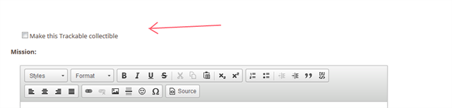
You need to select "Make this Trackable collectible" through the edit page option BEFORE you can move it to your collection.
Otherwise, that option to move it to your Collection never appears.
Thanks for explaining this. I have had a TB that made it home and it has been sitting in my inventory.
Ignore List Deleted
in How do I...?
Posted
Thanks, that did the trick. I was trying to "Bookmark" it like I usually do and the system needed a list name. However, I took you advice and went directly to the page and there was an Ignore option that created the list.