

YellowstoneHunter
-
Posts
8 -
Joined
-
Last visited
Everything posted by YellowstoneHunter
-
Benchmark Hunting in Yellowstone National Park
YellowstoneHunter replied to Golden Ace's topic in Benchmarking
Sorry, didn't mean to give you that impression. That's why I mentioned the chiseled boulders and spikes along the old Mary Mountain Road. I suspect all of those are older marks. The USGS did their own surveys of the park in the late 1890s, including triangulation surveys in 1899. I've not tried to located any records related to those, or to any of the 1870s surveys, which may have placed some markers as well. I may work on that for the 2nd edition of the book, but that'll be some years off. -
Benchmark Hunting in Yellowstone National Park
YellowstoneHunter replied to Golden Ace's topic in Benchmarking
Did someone say there weren't? -
Benchmark Hunting in Yellowstone National Park
YellowstoneHunter replied to Golden Ace's topic in Benchmarking
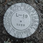
I started out with a data set pulled from the NGS database by the park's Spatial Analysis lab, and focused primarily on the markers that could be found in the front country (i.e, within a mile or two of the main or abandoned roads). I know there are marks chiseled into boulders and some spikes along the old section of road known as the Mary Mountain Road (or Trout Creek Road on the east side of it), but did not get back along those trails to try to find any of them. I was doing that part of the research late in the season (August/September), and there'd been a bear-caused human fatality a week or so prior along that very trail, and that area of the park was closed to hiking. So I focused most of my time looking for the PY0011/PY0949 marker and those that were monumented afterward, primarily by BPR in 1923, NGS, the USGS through their various earthquake studies, and the FHWA through the initial planning for the highway improvement project in the 1980s. As I was doing that, I'd come across the occasional undocumented NPS or BPR marker (or someone I knew would point me to one of them). Interestingly, very few of these are even in the park's GIS system (or were, I gave them that data). Even the Maintenance Office doesn't have a list of the markers they installed in the 1970s - it's as if they did the surveys (for the water system improvements and a couple of other projects) and then completely abandoned them. In reviews of the literature, specifically Hiram Chittenden's reports and USGCS/NGS/USGS reports, and through discussions with personnel in the various office responsible for the surveys, there was no mention of markers prior to the 1923 surveys (aside from the PY0011 and itinerant markers used by the USACE). I have not looked at any of Hayden's reports, however, so I don't know if he discusses or documents any marks he or his teams may have left anywhere in the park or not. Some of those old marks I mentioned along the MMR/TCR are listed in the NGS system, though (PY0909 & PY0929, for ex.). It is on my list of things to do to go find some of those, in fact. I'd intended to do that this past summer while I was there, but I'm working on a second book about Yellowstone and was busy doing the research for that, so I just didn't have time to get out into those areas. -
Benchmark Hunting in Yellowstone National Park
YellowstoneHunter replied to Golden Ace's topic in Benchmarking
All of the markers in the book were physically located, photographed (the marker and a context photo), geolocated, etc. The book has the identifiers, locator verbiage (summarized and converted into text an ordinary person can use to find the marker), and the latitude/longitude, along with an assessment of how easy it is to find it, whether it's accessible to someone in a wheelchair, and if it's "family friendly" (easy to access for someone with small children). The website has the photos and any other notes created since the book was published, along with links to their NGS and Geocaching.com pages if they exist. There's also a general history of the various surveys that were done in the park to explain why there are so many, why they were monumented, etc. There are several that I found that are not listed in the book or the website. I made the decision to not include those that were somewhat unsafe to get to, such as those along the side of the road where there's no pullout nearby (and thus, no place to park your car), those in thermal areas where no boardwalk was available, those in areas that spend a good deal of time closed for bear or other wildlife management functions, and so forth. The NPS expressed appreciation for that. Of those 550, a good number of them probably no longer exist. There are 53 that I was unable to locate, most often because the road has been realigned since they were monumented and in all likelihood have since been destroyed. There are also many in the backcountry that I didn't have the opportunity to hike to. All of the marks I found are listed (subject to what I explained above). This includes about two dozen that are not listed in the NGS database, mostly NPS benchmarks placed in the 1970s as a part of their re-engineering of the water system. There are benchmarks from USGS (including the CVO), BPR/PRA/FHWA, USCGS/NGS, USDI/NPS, and even one from the old General Land Office (now the BLM). I don't know the answer to that question. If you contact me via private message, I'll give you a POC in USGS that might be able to address that question, though. -
Benchmark Hunting in Yellowstone National Park
YellowstoneHunter replied to Golden Ace's topic in Benchmarking
It's actually not a "misleading" sentence. It is technically accurate, and is the verbiage the NPS wanted when I had them approve the draft of the book. I do discuss the subject of virtual caches and earthcaches, by the way (although in very limited detail since that's not what the book is about). Thank you to the OP for posting it. Dave Doyle wrote the Foreword for the book, too, btw. I did most of the research for the book in 2011, and Dr. Neil Weston (who was Doyle's supervisor) happened into the visitor center where I was working having taken a Boy Scout troop of his up to the summit of Mt. Washburn specifically to look for the three benchmarks up there. We had a very nice conversation about the surveying of the park throughout its history, and he offered to have NGS install a new one at Old Faithful (the old one was removed in 1972). Sadly, the NPS declined to have it done. Anyway, the book's got locator information for 300 of the 550+/- benchmarks in the park (including about 30 that're not in the NGS database), and the website has info on another dozen or so I found this past summer, for those who're interested. The website has photographs of all of the BMs plus context photos as well. -
The DSWorld submissions go into a queue and have to be manually reviewed before they're added into the system (according to Dave Doyle, NGS' Chief Geodetic Surveyor). I suspect with the popularity of benchmark hunting growing, they get quite a backlog of submissions.
-
Geocache Causes Lockdown at DisneyLand
YellowstoneHunter replied to YellowstoneHunter's topic in General geocaching topics
Now they're saying, uh, no, it was a "spiritual message of goodwill," rather than a geocache (but apparently there was a geocache incident last year???) Update -
Geocache Causes Lockdown at DisneyLand
YellowstoneHunter posted a topic in General geocaching topics
Probably not the best publicity for the game. Geocaching Game Triggers Lockdown at DisneyLand