


luckykoi
-
Posts
327 -
Joined
-
Last visited
Posts posted by luckykoi
-
-
It's a beautiful area I just went down there and grabbed 12 caches.
-
Frisbee'r just placed a cache at the trailhead.
-
Hello, I am staying in the Ancon district of Panama for a few more days. I really want to find a cache while I am in Panama but I'm the only cacher in my family and I'm a women, and I don't speak much Spanish, so I'm a little bit nervous about caching on my own in Panama. And we don't have a car here. Another problem is that many of the caches seem to be missing. The one closest to my hotel is missing as is the one on Amadore causeway. Any help would be appreciated.. Thanks.
-
A loose croc? Wow.. What other dangers are there for geocachers in Panama?
-
Why overcomplicate things with a "moving target" of caches? Why not pick the whatever number of highest caches you want, use the lowest elevation of those as the 'base' and the current number as the find count needed (100 finds above 6208, I think is the current). Then any new ones just widen the list.
Keeping it simple sounds good. Are any of the caches in the Olympics still on the list?
-
I'm planning on bring back the Washington's Highest Caches Challenge originally posted by and with the blessing of Moun10Bike. It'll generally be very similar though with a few slight rule changes, a new cache location and a new cache listing. I don't have an exact time frame yet but will look to have it going before the snow melts off giving access to the lower of the required high caches.
The cache will be here Washington's Highest Caches Challenge but the link will not work until the cache is published.
In the original challenge, I understand that there was an issue with caches dropping off the list as newer ones were placed causing them be removed from participants stats. My main change in the new listing will be to avoid that by allowing finds to stand if the cache was on the list at the time it was found.
Do you think that would address the issue fairly?
Sounds good. Will old finds count? I've found some of the highest ones and was dissapointed when this challenge was ended.
-
Heard on the radio today that they may be closing some trail this spring because of lack of funding. Si and Little Si were mentioned.
Just more scare tactics by a State Agency. They DRN is taking this right out of the state parks playbook.
The state is broke because Bankers destroyed our economy. They knew what they were doing but they knew they were too big to fail and they could force all the little people to pay for their greed. Privatize the profits and socialize the losses.
Here is a quote from the DNR
"Allow private concessionaires to try two pilot projects at DNR recreation sites — one in Western Washington and one in Eastern Washington."
Here we go, this is what this is really all about. Private companies are worming their way in so they can make a profit off public lands. This is the bottom line. User fees won't even put a dent into the budget required to run DNR lands.
A single pass for all state lands will be good at first. Then they will decide not to honor the pass at concessionaire run sites, just like the Forest Service has done.
This is all just another step in the privatization of our public lands and the WTO / World Bank style restructuring of our economy. Expect to see much more of this in the future and expect to see the “user groups" falling all over themselves to pay the new fees just to hike, while the working class (that includes everyone who has to work for a living, not just the working poor) bails out the people who created this mess in the first place.
-
Jimjamm wants to adopt:
GC186WD "Rest Here" Fine by me. Please give it to him.
-
Okay, well I better post something sooner than later

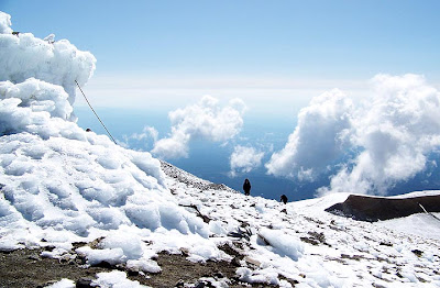
We arrived Friday night, around 4pm at the ranger station. We obtained the proper climbing permit and blue bags (everyone know what those are right?). We drove to the campground at the South Spur trail head by 5pm. The road up is narrow, rocky and dusty. However, I didn't have any problem in my low rider car.
We decided to do the hike in 1 day, getting up at 2:30 and starting by 3am the next day. Headlamps, and gear, we started up the trail 3:10am. Amazing view of the stars, by 5am it was begining to get light out. We were 4 climbing, Luckykoi and I a bit slower lost the trail in the night and ended up climbing some rocks to get back on trail. We meet up with the other 2 at the first snow bank. Crampons were not necessary, but I really enjoyed using them. (treking poles are necessary).
About 10,500 it really started to hurt, we were stopping every shot distance to catch our breath. I could feel that not trainning at elevation was hurting me now. I kept drinking water and we were all fine. We made it to the summit at 11am and met a ton of cool people along the way. The views were awesome. Walking over to the geocache at the summit, I was too cold to care about finding it. My GPS was low on batteries (I think it was just the cold) and couldn't find it after looking for about a minute. We retreated back to the shack where there was no wind and warmed in the sun.
The 5 hours of descent couldn't finish quick enough for me. I used my second pair of socks because my glissading techniques my boots were soaked. (Gortex what?). We finished before 5pm that evening and my body was exhausted! Nothing in particular was sore, but I was TIRED! I slept well that night!
I would recommend camping about 7,500 ft (before lunch counter) I'm not thrilled about carrying a tent over 300 ft elevation gain. Do the rest of the hike the following day with an option to stay a second night. The stars are amazing, and was a great time! Bring lots of socks and treking poles, you'll have a great time!
You can take a look at our pictures:
http://picasaweb.google.com/joebiker/2009_...feat=directlink
Good luck, and always be safe!
-Joe
Thanks Joe! My non geocaching trip report is at http://mosswalks.blogspot.com
Going up was hard for me but the trip down was easy once we were off the snow and ice.
-
The weather was perfect, I did the hike in trail runners and my jeep now has 187,000 miles on it. Joepesh might post a TR later.
-
I'm heading up to Mt. Adams this weekend. We are planning on leaving Portland Friday to setup base camp at the trail head. We'll summit Saturday or Sunday morning, deciding once we get there. Also it's possible we will sleep at Lunch Counter to enjoy the sunrise.
Anyone care to join us on August 14th or 15th?
-Joe
I'm going we a few portland area cachers.
-
We are meeting at Cold Springs tonight!
-
today is the day.. we are meeting up at Cold Springs Campground this after noon.
-
double posts don't know how to delete them.
-
I just found a live bullet, a loaded shotgun shell and a cigarette in one of my caches. I remembered seeing a thread about such. This cache container is a plastic peanut butter jar, it is not a safe container for storing such things. My cache had moved from its hiding spot and was in plain sight on the side of a trail. A group of 17 kids( who were with two adults on quads) walked right past my cache today. Several people have signed the cache logbook but have not logged the cache online. One of the finders did not know it was a geocache because they were not geocachers. They wrote in the log that they decided it was a container for storing used shotgun shells. Then they discovered geocaching and went back signed the cache logbook.
-
I am out for this year, if rescheduled for next year I would hope to make it.
Ditto. I would really love to do this climb in August, Love, but alas, I have to bow out for health reasons. However, I hope to be back in trim next year, so if it gets pushed to 2010, count me in!
(Remember GW8 is July 3, 2010, so try to schedule the climb after mid-July, so it doesn't conflict with GW8 activities and post-event collapse.
 )
)Ditto. Car repairs killed me this time. I can't even afford a vacation trip this year.
Ditto. Annie already knows this, but I can't make this year's date because my wife's 20th high school reunion ended up falling on that weekend.
For some reason my Jeep has been very reliable. My Jeep now has over 178,000 miles on it. I think it had 160,000 or more when I got it. We only drive it 3 times a month because it is a bit of a gas hog.
My Ford Aerostar was always breaking down and ending family vacations. The Ford Exploder (called that because the tranny explodes) uses the same tranny and a lot of the same parts as the Aerostar. I'll never again replace a tranny or an engine in a vehicle. I can get a whole car for less then the cost of replacing those parts. The best thing I ever did car wise was to leave my Aerostar (with it's new but failing tranny) in a wrecking yard.
Anyway, it looks like a few of us might be doing Adams the first week of August, I'll leave it to someone else to post the details. Thanks to Annie for starting this topic.
-
Luckykoi, I do not suggest Adams as a Solo!
Your current elevation gain is not good to be honest!
If you happen to be doing 3200-3800 in a couple miles daily and you have been doing this activity for numerous years, maybe just maybe.
True it is one step in front of the other, the Rest Step is truly wonderful.
But think before doing something like this Solo as if you are injured or fall, that group in front may not see you. Be Safe and wait until a group can go.
Please remember this is just some friendly advise....
I'll be in your neck of the wood this weekend for a Dog Show and hope to hit a few caches. I wonder if I can hit your first?
I just now saw your post; congratulations on finding so many of my caches over the weekend.
I was out hiking from Heart o' the Hills up to Hurricane ridge. That was about 5000 feet elevation gain with all the ups and downs. I was planning on hiking up to camp Muir as training before attempting Adams. I went up to Camp Muir a couple of years ago and have been wanting to go up Adams ever since. I don't know if I'll be in shape for Adams I've not been up that high before. 11,031 on Deseret Peak in Utah is the highest I have ever been. I normally start getting headachy at about 9,000 feet so it would be good for me to do some training at altitude. Hopefully I can find some one here or on North West hikers net to join me.
I try to stay in shape by hiking year round but some years it is easier then others. I know that if I put this off for a year there is a good chance I will never do it. Life can change in the blink of an eye.
-
I am out for this year, if rescheduled for next year I would hope to make it.
Ditto. I would really love to do this climb in August, Love, but alas, I have to bow out for health reasons. However, I hope to be back in trim next year, so if it gets pushed to 2010, count me in!
(Remember GW8 is July 3, 2010, so try to schedule the climb after mid-July, so it doesn't conflict with GW8 activities and post-event collapse.
)Ditto. Car repairs killed me this time. I can't even afford a vacation trip this year.
Ditto. Annie already knows this, but I can't make this year's date because my wife's 20th high school reunion ended up falling on that weekend.
As soon as I say I'm in everyone changes their mind
 Well I'm still interested, maybe I will go it alone. It sounds like you're never actually alone up there in the summer anyway. Last weekend I did 15 miles RT with 3,600 feet elevation gain but I need to do a lot more training. Adams will be a real challenge.
 -
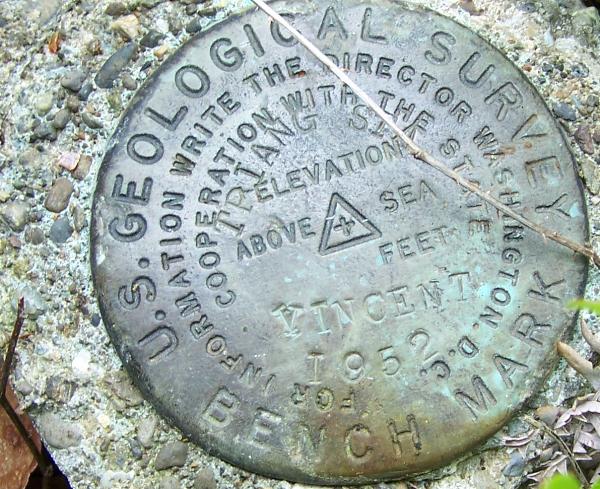 I don't see this one in the data base. It is on top of "grisdale" hill. The closest listed benchmark is dennie ahl reset and the closest geocache (mine) is at Grisdale Hill
Ok thanks..
-
The South Climb Trail is now on NW Trails V1.40. Thanks Jon and mvkazit. That should be nice to have along.
Is there a date set for this now? I think hiking up to the tree line and sleeping there out of the wind could be a good way to do it.
-
I don't see this one in the data base. It is on top of "grisdale" hill. The closest listed benchmark is dennie ahl reset and the closest geocache (mine) is at Grisdale Hill
-
I'm in but only if I can get child-care and I won't know if I have child-care until a day or two before.
-
As I said in previous posts, I am very challenged by electronic technology. I love to cache and want to be able to use a Palm to download pages from geocaching.com. I am trying to work my way thru instructions that I do not understand. Via Bluetooth adapter, I think I have down loaded the palm installation. And I think I have downloaded the GSAK data. But I can't make anything work. So now--could someone in this area, today or tomorrow, get together with me and help me set this up and explain very simply, how to use the interface, data and devices? I really am frustrated. Thanks. Bug Seeker (Judy)
I used Plucker and Spinner and they worked well together. You might want to try that instead. Now I have a GPS with a geocaching mode and it shows the hints or what ever else I program it to show using GSAK.
-
I'm looking at doing my first ever solo hiking trip away from home. i want to go the olympic national forest and camp around for a few days. hit the western side and towns around there (yes i am a twilight fan.) i was wondering if anyone here can help me maybe plan a bit better. Figure out what campgrounds are where and what sort of trails there are. any help?
You might like the Mount Muller trail and there is a forest service campground close to it.
http://mosswalks.blogspot.com/2007/08/mount-muller-loop.html

 Well I'm still interested, maybe I will go it alone. It sounds like you're never actually alone up there in the summer anyway. Last weekend I did 15 miles RT with 3,600 feet elevation gain but I need to do a lot more training. Adams will be a real challenge.
Cache Rescue And Adoption Area
in Northwest
Posted · Edited by luckykoi
All of my caches in the USA are up for adoption except for Haven Lake and Navy Patrol. My caches are all near Shelton, Washington.