

Muzikman
-
Posts
112 -
Joined
-
Last visited
Posts posted by Muzikman
-
-
Welcome Casey.
-
Is the mark you are looking for in the Geocaching or NGS database? What are the coords for the mark?
But in short, yes, metal detectors have been used and can be very helpful, especially with the older marks that were "at about ground level" and been covered up over the years.
-
 Good thing someone didn't think he was a grave robber:) I do agree, great discriptions. Lots of time put into these finds.
-
I agree that it looks like it was chisled out. It also looks like what remains (besides the pin) is just concrete. As for the distance, if those are standard 8" block, it's pretty close to 3.5 feet from the ground.
And if I am thinking of this layout right, as long as the 200ft and 69.5ft distances work out, that would be the mark.

-
Well, here is an older photo of the court house.
http://www.dcnyhistory.org/delhi_courthouse.html

It looks like the part of the building just to the left is new(er) as it looks like it was once two buildings, not one.
Not that this really means more than that there has been work done to the court house that would make the datasheet description inaccurate now. Though, looking at the old photo, where the remains of a disk was found would be the corner of the building.
-
Go here http://www.ngs.noaa.gov/cgi-bin/ds_pid.prl enter the PID BG3383 and check the "Include Destroyed Marks." box. Then click on click the submit button. You will then see the mark listed. Highlight it and click "Get Datasheets" button. This will show you the datasheet for it.
Basically that PID is in the NGS database.
That being said, there are many BMs out there that are not in the database, and as far as I know there are no datasheets for these marks.
-
Too bad the profile icon doesn't work. I'd like to see more detail about my fellow benchers.
Ted
Well, if you click on the persons name on the left side it brings up the profile. What bums me out is that the photos linked to BMs don't show up in the "photo gallery" in the profiles.
-
-
If you guys want a separate more "professional" forum and website for benchamark hunting I will donate the web space and setup the forums. I have a dedicated server with 120gb of space and enough bandwidth to choke a pig. I am by no means a web designer though, so someone else would have to actually design the page.
-
Look at the description for this one that I am going after tomorrow, Saturday. PF1173. Note the Telephone lines !!!!! I have plotted and calculated this as a 7-8 mile hike. I hope to gain a FTF and a FTR since 1910. Wish me luck.
Documented History (by the NGS)
1/1/1910 by USGS (MONUMENTED)
DESCRIBED BY US GEOLOGICAL SURVEY 1910 A HIGH, BALD MOUNTAIN RIDGE ABOUT 5.0 MI SW. OF WEST BETHEL. STATION CAN BE REACHED BY DRIVING TO FRED L. ORDWAYS PLACE, THENCE TO A POINT ABOUT 2.5 MI ABOVE, WHENCE A WELL CLEARED PATCH LEADS TO SUMMIT. NEAR THE SUMMIT IS A CABIN BUILT BY MR. ORDWAY AND SUPPLIED WITH STOVE, COOKING UTENSILS, WATER FROM NEAR SPRING AND TELEPHONE CONNECTIONS. STATION MARK, A STANDARD DISK SET IN SOLID ROCK. REFERENCE MARK, AN OLD COAST AND GEODETIC SURVEY DRILL HOLE WITHIN A CHISELED TRIANGLE, DISTANT 2.2 FT, N 28 DEG 43 MIN W.
I wonder if Mr ORDWAYS could cook you up some grub on your hike up

-
Actually it's kinda hard to see the abutments from the bridge. Besides, I have sawm that river many time. Though, there is a big sign that says no jumping or diving on the abutment in question:)
-
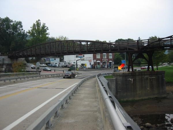
I gotcha. I was actually thinking back to what PFF said about the section of the trestle over Rt 381 missing on the Terraserver photo. That Sat image was probably taken some time in 1999 before the new bridge was complete.
I plan on heading back down there this weekend to see if I can finish looking for the 34+ marks along rt 381 and 711. I'll swing by and take a closer look at the top of that abutment.
-
For the benchmaks what I do is;
Go to the NGS website (http://www.ngs.noaa.gov/)
Click on the "datasheets" link
Click "Archived Datasheets"
Click "Yearly_Archives"
Select your state and then click the "Get County Archives"
Select the county you want and click the "Download File"
Save this file in a directory so you know where it is.
Go here (http://parkrrrr.com/) and download BMGPX
Use BMGPX to convert the *.dat file you got from NGS into a GPX file
I then open the GPX file up in GSAK and export it to what ever format I need (I use CacheMate for my PDA).
-
I will say one thing, I fequent many different forums that cover many different subjects and some of the bickering I see on the geocaching froums can not be topped by any other (except maybe pbnation.com). People in this world really need to learn to get a long

-
I did look as much as I could without climbing on top of the abutment. There did not appear to be anything there besides what looks like spots where old trestle supports might have been located at one time (aka: large indents and marks in the concrete). Though I did not have a tape measure with me, the abutment is not all that long and 20 ft would put it pretty close to the northern end of the abutment. The next time I am down there I'll climb on top and take a close look.
I just found that the Western Mayland RR bridge was rebuilt and complete in Oct of 1999. http://www.dcnr.state.pa.us/polycomm/nov/o...pbridge1199.htm
I have been looking, but I can not seem to find the date that the Route 381 bridge was replaced. I have been coming down here for years, but to be honest, never paid much attention to the bridge:)
-
Ok, I just looked at the terraserver photo and I see what you mean. The RR trestle spans the river, but then just stops when it hits the highway. My guess is that the photo was taken when they were referbing the tracks into rails to trails and that the part over 381 was removed and rebuilt, but I think the location is the same. If you look at the left side of the photo you see what looks like a newer cement abutment (on top of the older stone abutment) that the overpass connects to. At that point there is the Ohiopyle visitors center. This building was originally a train station.
-
The "overpass" you see in the photo is now a rails to trails bridge, but it was once the Western Maryland Railroad. From looking at old photographs from the late 1800's this bridge is in the same location. From that photo, behind me about 75ft is the B&O railroad which is not a bridge, Highway 381 (road shown in the photo) crosses the B&O at a railroad crossing.
-
Well, after the Falls Race in Ohiopyle, PA this weekend I did atlittle hunting. There were two disks right in down and one had been found by two people (though I am pretty sure they found the wrong disk) and the other was not found.
These are the two disks;
Where the description states JW0587 should be located there are two round marks in the concrete. It looks as if disks might have been removed and the small idents filled in with concrete. This seemed odd that there would be two markings and that they would go through the trouble of filling in the indents, but from what I can tell, this would be the location.
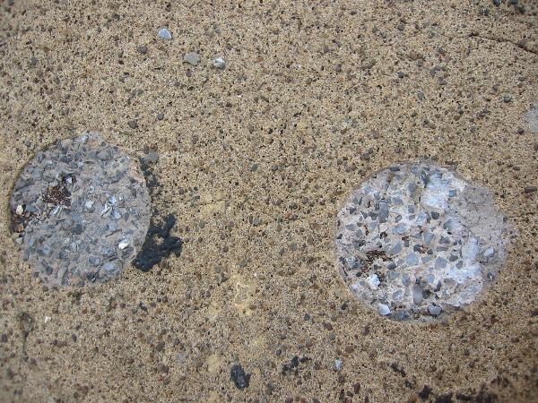
JW0588 I think was destroyed with the original bridge. The current bridge is no way from 1941 and one of the original stone wing walls remain. On the new bridge roughly where the old mark should have been located there is now a "PA Department of Transportation" disk.
So what do you guys think? Possible that one (or both) of the circles in the top of the abutment could have been the disk?
-
I am an odd one, alright. PI grows all over the place here (MN). I see it all the time when I am 'caching. I know lots of people who've gotten nasty rashes from the stuff. I don't know what's up with the likes of me, but I have had a lot of contact with this stuff- broken-off leaves, plant stems, etc. in contact with my clothes and skin - and I have yet to break out in a rash. I don't get it.
I was the same way. I have spent much of my life in the woods and in poison ivy and never got it. But let me just say, one day, you might and it might not be pretty. I am finally pretty much healed, just a few more red marks. I will say that is not something I want to go through again. I still refuse to wear long pants and shirts in the heat, but I will surely buy some barrier cream next year.
-
Two weeks ago I got some nasty Poison Ivy. It ended up getting so bad I went to the Dr (first time in 13 years). Got me some drugs that knocked it down pretty quick. My arm is still trying to heal.
Here are some pics I took.
-
Never mind, I figured it out. These apps all work great together...now it's time to actually pay for them.

-
That would be a "not found" with pretty much the description you just stated. Did you take any pics?
-
Hmm, nifty tool. I do have one problem / question. I am using GSAK (great little tool too) and when I open the GPX file that BMGPX created it makes all the waypoint names the designation name. I would rather this just keep the PID as the waypoint name. Is there any way of doing this? I am pretty new to GSAK (I have always used EasyGPS).
-
Well, my idea really isn't about geocaching, but about a different way to play paintball. I am very involved in the paintball industry and have many more paintball resources and friends than geocaching. So in my mind this is a paintball event, and will be advertised as so. If people who are into geocaching would like to come, but I think they might find the fact that it's not really geocaching.
THat's fine, good luck with your paintball event. Just don't expect it to be listed here as a geocache event.
I am not real sure how to take this, I was not talking about a Geoching event or even trying to list it as one. The idea came out of this thread is all. I'll just shutup now.
 Good thing someone didn't think he was a grave robber:) I do agree, great discriptions. Lots of time put into these finds.

Downloading Benchmarks In Gsak - Where?
in Benchmarking
Posted · Edited by Muzikman
in a command prompt type;
bmgpx <*.dat>
*.dat being the .dat file you downloaded from the NGS web site.
The other thing you can do is save the .dat file to a folder and then double click on it. It will ask you what program you want to use to open it. Choose bmgpx.exe and it will create a .gpx file in the same folder as the .dat file.
You can then use an app like GSAK to open the .gpx file.
Edit: Sorry, I missed you very first question. A command prompt, also called a DOS Prompt is where you type commands in a line.
To get to this prompt in Win95/98/ME click Start -> Run and type in "command" (without the ") and click OK
To get to this prompt in Win NT/2000/XP click Start -> Run and type in "cmd" (without the ") and click OK.
You will get a prompt similar to: C:\>
----
The other thing you can do is place the mbgpx.exe in the "Send To" folder under your profile. This would let you download the *.dat file from NGS web site, place it in a folder. Then using my computer or Windows Explorer, browse to the folder the *.dat file is located in, right click on that file and select Send To -> bmgpx.exe. This will also create a .gpx file in the same folder and with the same file name.
The send to folder is located under your profile. If you are using windows XP, it will look similar to thsi;
C:\documents and settings\jbeam\send to
(jbeam - being your profile name)