

Muzikman
-
Posts
112 -
Joined
-
Last visited
Posts posted by Muzikman
-
-
I have always set mine to magnetic, that way if I pull out the "analog" compass they are orriented the same.
-
Every time I have flown I have had my GPSr with me. I have never been questioned about it and in the past they even allowed you to use it. Now, my most recent flight (on NWA) from Pittsburgh-Detroit-Duluth, I had no problems carrying it on, but they specifically stated to not use, Cell phones, radios, TVs, or GPS unit.
-
I am very interested in this. I'll probably be in CA around that time, so I'll have to see if I can swing it. Two western trips in a few weeks might be pushing it with the boss:)
-
Best place to start is to send Jeremy (http://www.geocaching.com/profile/?id=3) an Email (contact@geocaching.com).
-
If I scan this, does this site have a place to post them, or do I put them somewhere and place a link here in a message. I am not familiar with how this forum handles such things.
- Jerry Wahl
You have to host the photo somplace else and then use the IMG tag to show them on the forum (or else it just becomes a link that someone needs to click on).
If you need space to place photos or any other files for forum use, please let me know and I can set you up with FTP access to my server. This goes for anyone else that needs space.
-
-
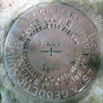
The PID is NK0390 and according to the datashoot that is a rivet. Do you have a photo of your find?
-
Worked for station name "INDIAN" in PA (in the Braddock Quad).
-
Hmm...
Trailblazers link does not seem to be working. But if you do it the old fashion way, it's there and working.
http://wwwest.ngs.noaa.gov/cgi-bin/datasheet.prl
then enter the PID GG0923
I am not sure where Trailblazer got that link, if maybe it was a bookmark, but it looks like maybe the NGS changed the way the search works.
-
This can happen some times with databases. Seeing as it's a weekend, they might be just doing maintance.
-
A .CSV file is a delimited text file. Usually can be opened in MS Excel.
-
The flow is basically this:
Dino Hunter downloaded all the datasheets for Utah and converted them into a GPX file which can be read by programs such as GSAK.
A few people said that was cool of him and a few asked how they can do it.
Dino explains the process
Rogbarn found that some of the benchmarks are listed in the wrong county.
That about sums it up.
If you would like more info on how to do this, here is a pretty good thread.
-
.I replace them as I found them.
But it would also depend on what type of area it is in. In the middle of nowhere, I might stick a marking rod in the ground. When I hunt benchmarks I carry a few 18" Fiberglass rods with the tops painted orange. These are used by gardeners to keep their plants up, but find that they are great for temp marks as you measure out distances and probing the ground for those hard to find buried marks.
-
If you do a search you will find a few hits on this. But to save you the trouble.
-Go to this site: http://www.ngs.noaa.gov/cgi-bin/datasheet.prl
-Click on the "Archived Datasheet" button
-Click the "Yearly Archive" button
-Select the state you want and click the "Get County Archive" button
-Select the county you want and click the "Download File" button (you can also choose which way you want the file to be downloaded (I usually choose "PC Unzipped")
-Go to this site: http://parkrrrr.com/ and download the BMGPX utility.
-Use GMGPX.exe to convert the .DAT file you got from the NGS site into a GPX file.
-Use a utility such as GSAK to open the GPX file.
-
Yeah, I saw that. But I assume the update was from a geocacher.
-
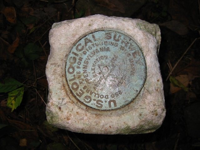
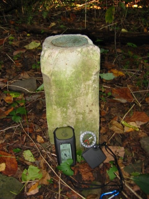
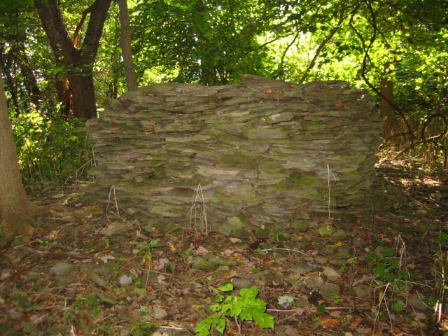
After looking through one of the threads and seeing the pictures of this find by Shirley and John it got me wondering.
There is a mark near a local cache and as it usually happens many people have logged it. But I am really starting to wonder if they are logging the wrong mark, and here is why. Please tell me if I sound way off here.
Mark is "INDIAN"
In the datasheet it states that the disk is in the top of a 33x6x6 post and that it is set 30" into the ground. There is then stones piled around it.
The mark that is found is in a roughly 6x6 post, but it is a lot more than 3" above ground. Although when I was there I did not measure the height, but it's atleast 12" above. I assume errostion could have been a factor, but seeing as the ground is very rocky and most of the rocks are large, I don't see them moving or settling very much in 100 years.
Then, about 20 feet away from the mark is an odd round pile of rocks about 4 foot high and 5 foot in diameter.
This makes me wonder, what are the chances of the real mark being under this nice pile of stone and that the USGS just placed another mark close by that is not in the database?
Here are some pictures.
-
Ahhh, that explains it then. Never thought it would be that far out of the ground.
That also explains the odd shadow to the right.
-
That photo looks really strange. Is it me or does that disk look larger than normal?
EDIT: That photo isn't photoshopped is it? The more I look at it the stranger it looks. Disk is in focus, but the feet are not. The shadow is cast on the sand, but not the disk. Just looks odd.
-
I still think a Camera with a built in GPS would be a cool idea. But the only one I found is not longer available (if it was ever officially released).
I am not sure what I would use Binoculars with a built in GPS for though.
-
Yeah, I am going to start thinking twice before even looking for caches in an open public place. I'll stick with my hiking trails.
-
once the file is downloaded, right click on it and select "rename" then rename the file to bmgpx.zip and then try running it. I looked it up an the PRL extension is a Perl Script file. I have no clue why your browser would be adding that extention. If you are using Internet Explorer I would check your PC for adware.
-
What operating system are you using?
-
That link should take you to the file you want to download. It is a .zip file. if you are running windows XP or ME you should not need any special application to open this file. If you are running another windows based operting system, then WinZip would be a good utility to have. once it is unzipped and the bmgpx.exe is placed in it's own folder you can then us it based on the steps I listed above. If you are still having problems. Drop me a PM (private message) and I'll give you my phone number and I'll try to give ya a hand over the phone.
-
Topo maps are best for off the beaten path. I personally like the state series National Geographic TOPO! maps. They are bit expensive, but very nice.
Gpsr And Airport Security
in How do I...?
Posted
I just posted this in another thread.
Every time I have flown I have had my GPSr with me. I have never been questioned about it and in the past they even allowed you to use it. Now, my most recent flight (on NWA) from Pittsburgh-Detroit-Duluth, I had no problems carrying it on, but they specifically stated to not use, Cell phones, radios, TVs, or GPS unit.