


Desert_Warrior
-
Posts
1389 -
Joined
-
Last visited
Posts posted by Desert_Warrior
-
-
Which E-Trex? Some don't have any mapping capability.
-
Energizer lithiums - the blue and silver ones - last noticeably longer than alkalines. They run about $10 for a four pack.
I use those as well, but I get the four pack for $6.54 at the base commisary.
Isn't being military or retired military great???
Yep, I keep some of those in my critical rescue gear.

-
OK - many of you guessed right. It is the barrel cactus in the middle. Only - it isn't small. It is 9 inches high and 12 inches in diameter. It covers a largeish tupperware container.
I have gotten several comments that they stood there looking at the cactus, then went aroound searching for something else, only to come back to it again later. This tells me that the cactus is a good start, the flat camo paint helped, and my coordinates are right-on.
Yes, you need to be careful reaching in there to get it, but that is part of living in the desert. Everything out here bites, stings, or stabs.
Lots of cool ideas here.....
-
I am using the MAHA 2200 mah Hi-MH batteries. In my Garmin 60CS, they seem to go 20 hours or more. That is more than enough for me - I can't hike 20 hours without a recharge myself!
-
OK... now that my latest has been out a few weeks, I will share the photo of the hide. Look carefully, can you see the cache container????
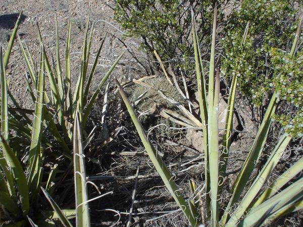
Take a guess. Maybe later I will post the answer here.
-
Stick with Garmin if you can. They work as well as any and better than some, plus your $$$s stay in the USA that way, not sent to a European country that isn't really our friend anymore. You can guess which one.
-
God bless you.
I was there in 91.
My son did his year and got back in May.
Cav scouts lead the way - BRAVE RIFLES!
Stay safe, and sleep is a weapon too.
-
are they as bad as the reviews i am reading? I have one i might sale but am just curious as to what its worth?
Here is the basis of what I understood you wanted to know. I replied with the information you requested as your message is quoted herein.
My answer was YES they are that bad, and RETURN IT IF YOU CAN.
Sorry if you didn't ask the right question to produce the answer you wanted.
I do not own and will not buy a cobra. I cannot help you further, whatever the question might be. Good luck with it.
-
Hmmmm.... well - you asked if they were as bad as you were hearing. I replied that in my opinion, YES, they were that bad. I told her to return it.
What more help did you want? Don't expect much more here, no one I know is using any cobra products effectively.
Seems you got a second opinion, basically saying the same thing.
Looks like you may have chosen poorly. Perhaps you can return it as defective and get something else, like a yellow E-Trex....
Good luck.
-
I use X-Band repeat all the time. If you look at a topo map of the Franklin Mountains in El Paso, (N 31* 50.xxx W 106* 30.xxx) you will see lots of canyons and spurs. I park the jeep outsice the canyon, and X-band the radio. That way I can hit the desired target from in the canyon.
Since I use an ICOM IC-901A fully loaded, I can even work DX on 10m or 6m while hiking. It is fun telling a DX station you are using a handheld in a canyon.
-
Let me start by saying that I have owner several Garmin products. I had a E-Trex Yellow, a Venture, a Vista, and now a 60CS. I have not nor ever will own a magellan, won't send a nickle to the french.
A lady at work showed up with a Cobra 100 and asked me to evaluate it for her. I did. I was not impressed. In fact, you might call it under-whelming! My old Yellow was far better, and the 60... well.... what can I say? *GRIN*
Let me end it by saying that after a few hours I gave it back to her, and advised her to get an E-Trex yellow, it was a far better unit. Dunno what she did with it, but it is her $$$$ and her business.
-
I use the VISTA data, and modify the peramiters to fit my needs. Yes, you must use a SERIAL CABLE to work with NG TOPO.
If you want a good laugh, contact TOPO support and ask about USB. The support guy Michael Wildshut is a real trip. He tild me that Garmin had to send me a driver for the USB cable on my 60CS. I tried several times to get him to understand, but he just couldn't grasp the concept. He swore that NG TOPO supports USB, if I had the cable driver.
What a shame - TOPO is otherwise a good program.
-
My son James did some caching in Iraq when he had the time. His user name is Army_Scout. Drop him a line and see if he wants to participate.
-
Hmmmm somehow your post got overlooked.
CONGRATS!!!!
Another ham.... and sorry, but you are not a real ham!
Real hams can be cured! Welcome to the group.

-
Would work out well for my daughter, just got her her own E-Trex.
Thanks - what a nice thing to do.
-
In one way I like CO-Admin's stance.
I want people to log the find on the site.
In fact, I think if you won't log it, then don't go look for it.
The rest is relative to me, I live in West Texas. Travelling anywhere is 50 miles, but at 75 mph, it isn't a big deal. I can probably get to Las Cruces NM before a New Yorker can get to Wal Mart.
-
I am in El Paso. Use zip-code 79922 for your search.
There are several nice caches in the Franklin Mountain state Park. (Some of them are mine
).Don't know about what is on the road between, I never travel east of here.
-
How about this one? It is not "just a disk" On the other hand, it is NOTHING ELSE BUT a marker.

This marker is on the border between El Paso, Texas, Sunland Park, New Mexico, and Juarez, Mexico. The junction of 3 states and two countries. This is the first of a string of markers going from the Rio Grande to the Pacific.
-
CONGRATS!!!
Look in this area for some threads called "WHAT DO YOU USE" Part 1, 2, and 3.
This will give you some ideas of what others are using and why.
-
I had the same problem. A local state park has an annual exposition. The entry fee is waved that weekend, so the park is full both days. They asked me to set something up about Geocaching.
I had information on the table introducing Geocaching. I also set up an event cache for the cachers, and a kiddie-cache where my daughter taught the kids how to cache, and they could take one toy free when they found the cache. It was a great success, and netted a number of new cachers.
I tried to do the same the next year, and was told the cache would not be approved. Hmmmm... Well, as I see it, it is geocaching's loss, and my gain as it frees me up to do something else that weekend. Too bad, because we need more cachers and caches in this area.
So now I lead a few hikes that weekend. I am still doing volunteer work in the park, but the opportunity to introduce more visitors to Geocaching is lost because of a rule.
Like I said, it is Geocaching's loss, not mine.
-
Wood staff? Where do you chuck it when it is in the way???
Give me a nice set of colapsable sticks ANYTIME!!! There when I need them, tied to my pack when I don't, and I never need to look for a stick while shaking in fear from the ever observant tree-huggers.
Trekking poles are available everywhere... check some out.
-
As was pointed out, not many are as observant as Geocachers. Times have changed. America, and most other civilized nations for that matter, have learned about terrorism. Being a retired combat vet, I think myself more aware and observant than most.
My first brush with terrorism was in the very early 80s, when they blew up HQ-USAFE at Ramstien Air Base. I was attending an army school there. I was two blocks away, and the concussion knocked me off me feet. I lived as such that I had to inspect my car every time I approached it, my garage door, and mailbox, etc. Americans overseas were targets then, but mainland USA seemed to be safe. Evertually the Army went to license plates for our cars that looked like the European plates, and the car bombings slacked off.
I have not forgotten any attack since then, from Bayrut to 9-11. America and its citizens have been lucky for over 20 years. But we are in their spotlight now.
Some think I am paranoid. My house has standing orders tied to the colored alert levels. Things like fuel in the car, money in the wallet, bug-out kits, weapons and ammunition, back-up communications, contact numbers to rally to for the city, state, or across the country-wide disasters, etc... all part of the plan. When danger strikes, it is too late to plan. You should have a few basic plans for situations ready, then act when needed. For instance, yellow alert, - your car is never below a quarter tank of gas. For Orange alert, not less than half a tank.
Divine's comments are amusing. I have long ago concluded that he lives in another world, and his comments are mostly not appropriate for our situations. They probably don't worry about stuff like this in central Mongolia either. But I do find them amusing.
The local police and fire know me. My home is a good place for coffee and sodas, a back-up phone call or radio, ammunition and weapons, whatever I can do to help. My wife even trains their dogs. Trust me, they appreciate citizens taking an active roll in the security of the neighborhood and city.
I say keep on caching. Get friendly with your local officials. Be alert. Help them when you can. Keep out of their way when you can't help. And if someone is suspicious of your action, take the time to introduce them to yourself and what you are doing. Mostly they fear the unknown. Once they know why you and others go to that same spot, it might even become a game for them to watch and laugh at.
Hope you found my musings both amusing and thought-provoking. What is in your bug-out kit? Do you have a bug-out plan? Rally phone numbera and rally points? God knows I hope none of us ever need them. But still..... what if???
-
Let's see. They do this all over the country. All over the world I would bet. There are about 100+ stations in the USA releasing them. Go to THIS PAGE to see where the nearest station may be to you.
Mostly the package can be reused. However, once they are launched, salvage rights apply. If it is a new model, we usually keep a few as souvineers, disassemble a few to refine our receiver specs , then start sending them back after that.
Look for a program called balloon track by Bull Brown. If you take the sounding data as a text file and process it in balloon track, you can get an idea where they are landing. We have seen errore of 1/4 mile to 12 miles.
The weather service really does not care where it lands. In fact, the data they collect up to 100 milibars pressure altitude is all they care about. 100mb is about 50,000 feet. Typically, a balloon goes over 100,000 feet before the balloon bursts.
NOTE: The next generation transmitters will have a GPSr built in, and will send a digitally encoded bit stream with the lat/lon data encoded. We are already looking at ways to capture that data to more refine our operation.
Sorry for the delay in answering. I was in a car accident. My jeep has some damage to the rear where I got hit, but would be drivable if it were not for the gas tank leaks. The other car is really destroyed. 1976 jeep is real steel!
-
And if you need help with TOPO, better ask here. The fool running TOPO support is a real work of art.
Still, TOPO is a great program.
Yellow Jtbs
in General geocaching topics
Posted
Hmmm... I think we should take ALL the yellow jeeps, and ALL the french-made magellans, and ALL the whining complainers that don't like the FREE service this site and the volunteers provide, and send them off to their own web site where they can whine and YJTB and magellan their way to further unhappiness.
I hope my point wasn't too obscure!
IT'S A GAME PEOPLE. PLAY IT, OR DON'T PLAY IT!!!
SHEESH!!!!!