

Desert_Warrior
-
Posts
1389 -
Joined
-
Last visited
Posts posted by Desert_Warrior
-
-
 My final decision.... I bought ExpertGPS. It seems to do all I want except one thing. And it may be that I just do not know how yet.
Thanks Y-all, I learned a lot!!!
Mike-KD9KC
-
It is very much like MGRS. Thats Military Grid Reference System. Accuracy to 10m on a 1:50,000 map is expected from every soldier. I have probably spent more years doing MGRS than some of you have been living. In the Gulf War, GPS was just coming of age. The smaller units (us) didn't get GPS equipment. We had a LORAN unit, but it was only good near the coast. My unit was stationed at the airbase outside Khobar Towers. LORAN was OK. In late January 1991, I was selected to lead a 6 man spcl ops team north. They gave me the LORAN unit. Once we got NW of Riyadh, it was worthless. We ended up in the desert 50km east of Rafah. In the ground assault, we pushed in with 18th Abn Corps, 24th ID (mech). We went north up MSR Texas, then swung East through As Salman, Iraq, and finally halted 100 hours later near a HAWK missile Battery. This was all done with MGRS maps and a good compass. Later on, GPS became more available. I imagine every squad has at least one now. But unlike the pyramid games, you do not find a battery machine in the desert. So I still teach cadets map-compass-protractor.
One good thing about MGRS. Maps are all to the same scale. I prefer 1:50,000, but I can use others. By the time I retired from the army, I had collected quite a few maps, and I use them quite often. It wasn't till just weeks ago that I got my first USGS topo-map.
Sorry for the rant... just an old soldier remembering...

Mike. KD9KC. U.S. Army Retired.
-
On one of my outings, I was on the other end of the mountains from our usual repeater. So here is what I did.
I set up the home station to cross-band repeat from the 147.16 repeater to a 446.xx simplex frequency. Then I pointed the home antenna at the park we were going to.
At the park, I set the mobile radio to cross-band repeat from the 446.xx simplex freq to a 145.xx simplex freq.
On the hike, my handheld was able to work the usual repeater by using the double hop from me to the car, to the house, to the repeater. Of course, I had to ID KD9KC through KD9KC REMOTE just to keep it legal, since none of the radios had an auto CW-ID.
Just an idea you might use on your own outing.
Mike. KD9KC
-
Really mean South-West style mustard. Perhaps I shold put a jar of it in the next cache I visit. Will mustarg spoil if not refridgerated?
Mike.
-
Originally posted by park2:
These things draw so little power, I just let mine run for days at a time. My G12 drew like 60mA which would kill an average truck battery in about 2 months.
This is because the average car/truck battery is designed for a huge power surge, then an immediate recharge. The average lead-acid car battery is really only usable for about 10-% of its capacity before it sustains damage. OTOH, a deep-cycle battery is much more suited for the long-slow discharge you are talking about. But... they are not designed for that sudden surge of starting power.
Your G-12 at 60mA is good. My E-Trex is 150mA running normal, and 220mA with the back-light on.
Anyone wants a disertation on battery capacity and current drain... ask. Otherwise I will not bore the group here.
Mike.
-
What you want to do is quite simple really. It could get a little more complicated, depending on your GPS. My E-Trex needs about a 2 second push on the ON-button to make it fire up. This is probably a longer duration than you will have using the door-lock command. I would do it with a 2 pole latching relay, and an electrolytic cap for the holding voltage. I would set the cap to charge instantly as the circuit energized, then let the cap discharge through the resistance of the relay coil slowly. The length of the contact timing would be set by the resistance of the coil and the capacity of the cap. Note, a 12VDC relay needs only 7-8 VDC to hold, but the full 12 VDC to pull in, so this would be a help too.
If you only need a momentary contact, a single pole single throw relay will do it fine.
Mike.
-
Thanks... I do not normally backpack a laptop, or any kind of computer, on our outings. And my GPS is an E-Trex. It looks like Fugawi is much more than I need. But I did mark it for future consideration should I upgrade.
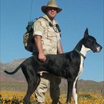
The picture is me and a 22 month old Great Dane. He is black/white, and tries to stay in my shadow when the sun gets too hot for him.
Mike. KD9KC
-
I posted this question in the getting started area. Got about 100 reads, and NO answers. I do not believe I am the only person in this spot....
I had been using Street Atlas USA for talking to my GPS. I found it clumsy, but workable. Then I discovered EasyGPS from this site. Nice, but no mapping. But... then there is ExpertGPS. Been playing with it just 5 days now, and I like it.
Having said all that, what are you using and why? What would you spend the cash on if you had to have just one program... mostly for topo work, but some streets too?
Thanks. Y-all have a great evening.

Mike and Parker testing out the E-Trex in the Franklin Mountains.
-
Found the cache. Took the tractor. Left a quarter. Coordinates were a bit off, but we did enjoy it. Thanks.
Won't happen.... BET!
Mike.
-
We are moving right along here. I had been using Street Atlas USA for talking to my GPS. I found it clumsy, but workable. Then I discovered EasyGPS from this site. Nice, but no mapping. But... then there is ExpertGPS. Been playing with it just 3 days now, and I like it.
Having said all that, what are you using and why? What would you spend the cash on if you had to have just one program... mostly for topo work, but some streets too?
Thanks. Y-all have a great evening.
My dog Parker and I, testing the E-Trex in the Franklin Mountains.
-
Started out as a 24H. Since I have been in electronics since the age of 8, I soon picked up 24J. Years later I became a section chief, and got 26H. Later, also took up 24K. By the time I was in the Gulf War, I ended up driving a mobile repair shop for electronics into the ground assault. I went in right behind 18th Abn Corps, 24th ID (Mech). We tried to repair anything with electrons running through it until we lost our truck (and almost our lives) to a mine or something. Got pretty hairy there. After the Gulf War, I spent 4 years doing Counter Narcotics operations in a multi-agency roll to the south of the U.S. For my last year, I was NCOIC of the Ft. Bliss MARS station. I am just starting my 8th year in a new career. First they give me a power plant to play with. Then they send a bunch of great guys to play with me. (All hams too). Then every two weeks they dump a huge amount of money in my bank account. And I do not need to jump out of a plane or get shot at to collect! Life doesn't get any better then this!
Mike.
-
Howdy Y-all,
Stumbled across this web site while researching information on the Franklin Mountains in El Paso, TX. I am retired army. I have been training some HS ROTC cadets on land navigation. Since I know I can do it, I have been using a GARMIN E-Trex to verify the cadets' resection skills.
I noticed there are a few caches in the local area. I thought it might be neat to translate the Lat/Lon to MGRS, and assign the cadets the task of finding them. But before I do this, I wanted to make sure it would be OK. I would be accompanying them. So is it, and are there any rules to be obeyed... or anything I/we should know?
Thanks Y-all. Have a great weekend.
Mike.
U.S. Army Retired.
My E-mail address: mailto:kd9kc@elp.rr.com
Ham Radio page: http://www.qsl.net/kd9kc/
Gun page: http://home.elp.rr.com/elpasochl/
Dog page: http://www.geocities.com/heartland/estates/4174
Member:
National Rifle Association.
Texas State Rifle Association.
Fort Bliss Practical Shooting Club.
United States Practical Shooting Association.
Gun Owners of America.
Holder:
Texas Concealed Handgun License.
Freedom is expensive. Those who are not willing to pay the price ultimately lose everything.
Let me try it here... Help please....
in GPS technology and devices
Posted
Thanks Y-all, I learned a lot!!!
Mike-KD9KC