


Desert_Warrior
-
Posts
1389 -
Joined
-
Last visited
Posts posted by Desert_Warrior
-
-
I don't have the answer for you but people over here are having the opposite problem so there must be a way to change from feet to miles and miles to feet.
Thanks, I asked the question there now too. Actually, what they are getting (0.01 miles) would be fine for me. Hope they have learned how.
Mike.
-
I did some playing with proximity point alarms yesterday, I concluded that feet are NOT an option. The smallest unit is 0.01 miles or ~50 feet. Also, I only got an alarm when I entered or exited this circle, not the point itself.How do I change the default settings on my proximity points from Miles to ft? I am using Garmin 60csx. Any ideas?FWIW
Hermit
Right- that's what I was figuring out as well. Is there a way to set the default to this 0.01mi instead of 1.00mi? I hate having to change every point's proximity alarm each time I enter one...
Hmmmm - anyone get this worked out yet?
I seem to be having just the opposit problem. I am loading POIs into a Garmin NUVI-350. I don't mind the REDLIGHT CAMERAS being in feet. That makes sense. But there is a limit to feet. It is 200,000 feet, or just over 37 miles. I would like to do 50 miles, or 264,000 feet for some of my POIs. So for those POIs I would prefer to do it in miles too. I have not found a way yet. Any insight?
Thanks.
Mike.
-
Well, I don't have one of them newfangled machines, but on my 76CS when you select a waypoint and press "menu" you are presented with a "set proximity" option. Maybe POI's work the same?
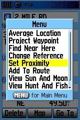
Edit to add image
Good morning, and thanks for the reply.
OK - I figured out how to do it in Garmin POI loader. Select MANUAL and it will prompt you for speed or distance from. This works great for red light cameras and geocaches. Actually, anything within 37 miles.
HOWEVER - I thought of yet another use. I am a ham radio operator. I am a member of a closed system of linked repeaters. I have the LAT/LON of each one in a .GPX format file. I tried to load them all (150+) into the NUVI 350 and set the proximity range to 50 miles (a good choice for radio range). It seems POI loader only uses feet. OK - 50 x 5280 = 264000 feet. Bad answer - it seems to be limited to 200000 feet.
Anybody got a work-around? Or do I need to edit each and every point manually? CAN I edit POIs in the unit? Do it each time I load them? Someone has got to have discovered an easier way.
Thanks Y-all.
Mike.
-
Howdy,
I have been inactive for a while. Life getting in the way of caching I guess.

Taking a trip to a dog show. I would like to load geocaches as POIs into the Garmin NUVI 350 and set a proximity alarm to alert me when we get within say 10 miles. Time to fire up the 60CS and get ready to stop. I could probably experiment and figure it out.... but I am running out of time, we leave Friday morning. Got lots to do still... and then there is WORK!
Can someone point me to a tutorial on setting proximity alarms, or give me an example of a .GPX or .CSV format. Once I see it I believe I can get her done.
Thanks.
Mike. KD9KC.
Desert_Warrior.
El Paso, TX.
-
Hi everyone, I'm hoping someone can give me some advice here.
 So, now I have to replace it before he gets back into town on Sunday, (or at least be in the process of replacing it),
 Soooo.... what happened? Dod they kill you or what????
-
Well - guess none of my old friends are here anymore.
-
OK. Let me start by saying it doesn't look good for a handheld.
I placed the center point at the lake. There were no repeaters within 25 miles - this is what I consider reasonable range for a handheld radio. The nearest repeater was 38 miles. But since I do not know where exactly you will be, I opened the list to 100 miles. This list isn't coming out here, so I will make it comma separated values. Just add one (or more) tabs for each comma (,) and get the columns to line up. Here is the list.
OR - you can import it to Excel!
Seq,State,City,Output,Offset,Callsign,Notes,CTCSS,Sponsor,DX,Brg
1,MONTANA,West Yellowstone,145.230,-,WA7FDR,ol 100.0,100.0,WA7FDR,38,291
2,IDAHO,Sawtell,145.230,-,WA7FDR,oL(W/PL 123.0),100.0,WA7FDR,53,278
3,IDAHO,Driggs,146.940,-,K7ENE,o, ,MCCD,63,216
4,WYOMING,Cody - Cedar Mountain,146.850,-,KI7W,oels,CMARC,64,86
5,WYOMING,Cody,448.350,-,KC7NP,o, ,KC7NP,64,86
6,MONTANA,Emigrant,145.290,442.1,KD7HEW,oa, ,KD7HEW,65,344
7,WYOMING,Jackson,146.910,-,W7CAT,oarx 91.5,91.5,TCORACES,70,196
8,WYOMING,Jackson - Rendezvous Mtn,146.730,-,K7JAC,ox, ,K7JAC,70,196
9,WYOMING,Dubois,146.820,-,KD7BN,olx 100.0,100.0,HERC,73,150
10,WYOMING,Dubois,146.820,-,KD7BN,oex 100.0 L,100.0,KD7BN,73,150
11,WYOMING,Dubois,147.315,+,KG7ST,oelx, ,KG7ST,73,150
12,MONTANA,Red Lodge,147.000,+,WB7RIS,oe, ,BARC,74,47
13,MONTANA,Red Lodge,449.900,-,KA7MHP,o, ,KA7MHP,74,47
14,MONTANA,Big Sky,146.820,-,W7LR,oE-SUNl 82.5,82.5,ERA,76,319
15,WYOMING,Powell,147.255,+,WA7QNS,o, ,WA7QNS,81,75
16,MONTANA,Bozeman,145.250,-,KB7KB,oalz, ,BARBS,90,339
17,MONTANA,Bozeman,146.880,-,W7YB,oaex, ,ERA,90,339
18,MONTANA,Bozeman,147.180,+,KB7KB,oelx, ,MRLA,90,339
19,MONTANA,Belgrade,448.850,-,WB7USV,o 100.0,100.0,BARBS,90,339
20,MONTANA,Bozeman,447.000,-,KL7JGS,oae 162.2,162.2,BD Hosp.,90,339
21,MONTANA,Bozeman,447.700,-,KI7XF,oa 77.0,77.0,ERA,90,339
22,MONTANA,Bozeman,448.350,-,KB7KB,oexL(IRLP) 77.0,77.0,KB7KB,90,339
23,MONTANA,Bozeman,449.900,-,KL7JGS,oaeWX L(IRLP),110.9,KL7JGS,90,339
24,IDAHO,Rigby,146.700,-,K7ENE,o, ,ERRS,94,235
25,IDAHO,Rigby,146.880,-,K7ENE,o, ,ERRS,94,235
26,MONTANA,Greycliff,147.280,+,N7VMR,oelx, ,MRLA,94,17
The last two numbers are the distance (DX) and heading (Brg) to the repeater.
Hope this helps.
-
I am going to Yellowstone Wy in June and have a VX-7. Are there any repeaters in the area and how much chance do I have of contacting anyone. I am really new at this and would appriciate any help offered. I have made up the 2 meter antennia mentioned in another topic concerning backpacking. Thanks for your help.
Trees.
Hang on - I will try to get a list for you. I assums 2m and 70cm?
-
EDIT: System double-posted...... deleted second copy.
-
You might be able to get some ideas from the following threads.
The first and third especially - lots of stuff about handhelds.
One idea you might consider. I took this idea to a level above most. You might consider a radio that will allow you to have interchangable battery packs. I currently use battery packs that carry 6 AA batteries. This takes the 5w radio down to 3.5 w. At 3.5 w, the battery drain is much less. Using a gain antenna more than makes up for the lower power with 2.1 dB gain. The ERP is over 6 watts!
By using the AA packs, I can stuff them with the latest in battery technology. This gives my better than 24 hours on a battery pack. Plus - and here is where I took it beyond the norm - every electronic device I carry except the cell phone uses AA batteries. So now I only carry one type of spare battery.
We will save the "Who makes the best battery?" question for another time.
Hope this helps.
-
-
Hello friends, old and new. Just wanted to drop a line and say life is still going very well out here.
Way too much to type. Still a ham. Parker the Texas Chihuahua still hikes with me. We have over 40 hikes listed on localhikes.com now. Parker has earned his fourth title in obedience. Jeep motor is dieing, but I have a 93 4.0 EFI getting rebuilt to replace it. Got another few modules for the jeep radio. It now runs 28, 50, 144, 220, 440, 1200, plus 144 SSB and receives from 0.5 to 1000 MHz. Got the wife a new van, and bought a second IC-901a for it. She works 144, 220, 440, and 1200.
I picked up yet another hobby. Letterboxing. In some ways, I like it better than Geocaching. Instead of a box of junk you get a nice stamp in a logbook. I have converted most of my Geocaches to Letterbox Hybrids.
My son James finally got a ham license. He just returned from his second tour in Iraq. Those of you who remember me know James is a Cavalry Scout. He is also a paramedic. And he became a sniper. He was decorated for over 200 combat missions as a sniper this time. He is KC0WKY, currently at Ft. Carson CO... but moving to Ft. Hood TX soon.
Hope all is well with you-all. I will drop in again soon to see if there are any replies.
Y-all take care.
Mike. KD9KC
-
Thank you...
-
Good afternoon.
I need to get in contact with the cache approver for West Texas - the El Paso area. Or N 31º 55.000 W 106º 30.000 area. Can anyone point me to a contact adderss or whatever?
I have some questions about my present caches, and a few future caches.
Thanks.
mike2004@elp.rr.com
-
I love National Geographic TOPO. But it has some other problems, like cost and support.
The National Geographic TOPO state series is about $100 per state, although you can get it cheaper if you shop. Furthermore, their support man Michael Wildshut is a nightmare. The man has no concept. A USB cable does not NEED a driver! But I digress. If you install the TOPO Streets and 3-D views, ($20 option) it is by far the best valus for the $$$$. Just don't ask Michael Wildshut for help! Use the forums here instead.
I also use Back Roads Explorer. But it has some other problems, like some states do not have the 7.5 min maps as the state series has. And of course its support comes from Michael Wildshut again. If you tell me what state, I can check Back Roads Explorer for you. Lemme know...
I also use Garmin Mapsource TOPO. Mostly I use it to upload maps to my Garmin GPSmap60CS. I do not use it enough to tell if it will make your tracks.
Last, but most often, I use ExpertGPS. Other than support for custom Icons, I think it is a great program. Great support (except for the custom icons) and 1/2 the price of National Geographic TOPO. But of course, National Geographic TOPO has more functionality, like 3-D maps (with the option) and elevation profiling.
Tough choices - good luck. I believe that like me, eventually you will own them all!
Mike.
-
I have picked up 5 so far on E-bay for $50 - $60 each to give away to kids. Give it a try.
Mike.
-
I bought mapsource TOPO on E-bay for around $70 + S/H NIB.
-
Thanks,
Steve Cody
p.s. A plug for the Middle East maps... If you travel to Qatar, Kuwait, or any of the other countries on the Middle East maps, they are a MUST HAVE! I travel quite a bit to virtually all of the countries in the maps (all but Saudi) and so far they have been awesome. The street level maps are great and the points of interest are as well. I've used them both with the Street Pilot and GPSMAP 60cs.
Where did you get the middle-east maps? My son is on his second tour over there, and I would love to have the maps both for him and for me! What countries are covered?
THANKS !!!
EDIT: spelling of course!!!
Mike.
-
THANKS !!!
That is SO outstanding.
With this addition, I do believe NG-TOPO will once again be my favorite program.
THANKS AGAIN !!!
Mike.
-
Got what I was looking for - new original at a great price.
Thanks.
-
Very interesting indeed!
One question not answered by the stuff I have read. Once installed, is it possible to view maps in the original flat form as well as in the new 3-D form. I am a reporter for Localhikes.com, and I must submit the maps in flat form on that site.
Also - does it work with Back Roads Explorer?
Please reply ASAP, I am ready to order it.
Thanks.
-
Actually, this is the area I was speaking of.
TOPO 3.4.3 has been out over two years now. There was an updated version promised that would allow connectivity with the latest GPSRs and USB connections.
However, the link you provided is very interesting by itself. I will need to investigate it further. Thanks.
-
Good morning.
After going around and around with that wonderful
 tech support guy Michael Wildshut at National Geographic about support for the newer Garmin units and USB cables, it was rumored that there would be a new update to follow. It was promised for the summer... of 2004!
I have not found it yet. I don't feel much like calling or E-mailing Michael Wildshut at National Geographic about it either. I would sooner bang my head on a brick wall, there is more opportunity for reward doing that. But I was wondering if anyone has heard any more "rumors" about it.
Thanks.
-
Anyone got it used for sale? Contact me please.
Mike.

GARMIN - what's the value?
in GPS technology and devices
Posted
What would someone expect to pay for a very clean not scratched up and working perfectly GARMIN GPS-MAP-60CS - latest software update - including manual, USB cable, serial cable, batteries and original box? I mean - this thing is like NEW! Ready to go out of the box.
Thanks.
Mike