


Desert_Warrior
-
Posts
1389 -
Joined
-
Last visited
Posts posted by Desert_Warrior
-
-
Any of the old crew around? I've been away - but I am still around.
-
WOW - lots of good data. Looks like I will be able to put this together for them. Thanks Y-all. I really do appreciate your info.
The only thing I dis-agreed with was:
Wikipedia. The answer is always there.I once believed that. Wikipedia has some data from sources that are less than reliable for whatever reason. I have gotten to the point where I don't even think about Wikipedia any more.
-
I seem to always come here first for answers. Not often, but always first.
I hike way more than I Geocache. I am a volunteer in a local state park. 37 square miles of desert mountain range, only 4 rangers to cover it. Having me patrolling the back-country really helps them.
I have mapped out many of the trails in the park on my GPS. The better hikes are listed on localhikes.com, look under TX-El Paso.
The park has asked me if I can provide them with my tracks for the state to make park maps from. They use something called GIS. The actual programs they use are not available in the field, the rangers could only tell me "GIS". They don't know more than that, I would need to go to the HQ to see the program.
What is GIS? Does anyone know of a SIMPLE way to convert .GPX (or .TPO) to whatever GIS uses? I don't even know what format GIS uses. I am more than willing to provide them my track logs, I just don't want to spend $100s getting a program I don't need for anything else. I can provide them the track logs in .GPX format or .TPO format, but I am not sure it would help.
Looks like it is time to learn something new - again.
Thanks Y-all. This forum is a great resource.
-
OK - thanks. I don't have a MAC - but a friend does, and that question came up. She is not a Geocacher - but a Letterboxer. But I knew Geocachers would have the answer.
A rare day - it is SNOWING in El Paso.
Thanks again.
-
Using a PC, if you type <ALT> 167 you will get the degree charactor.
º as in 31º 12.345 106º 67.890
How do you do that with a MAC?
Thanks.
-
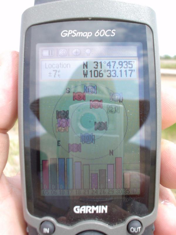
WOW - I typically get 7-8 ft accuracy out here on my CSx. But then again, the only shade is from my hat! This shot was taken long ago, with my 60CS - along the Mighty Rio Grande, several miles west of the Franklin Mountains.
-
anyone tried geocaching with this model
I use one in the dog-show van. I upload the caches to it, and let it route me to the closest point to the cache on the road. Then I grab my GPSmap60CSx for the final trek.
-
Lots of good suggestions on the mapsource. I will call him and try to explain it.
He tried to call me on Father's day. AT 0500 !!!!! I was sleeping in a motel in Rio Rancho NM. My cell phone was off. So I tried to return his call later. It rang and rang and rang. I was about to hang up when he answered. I heard the roar of a diesel motor and the squeek and clatter of tracks. He shouted into the phone "I don't know who you are and I couldn't hear you anyway... I am driving my Bradley in convoy right now - goodbye. I smiled and hung up. I still miss it.
He will not have the opportunity to download anything - and there isn't any easy way to send him a CD. Kinda funny - but it was easier to get things to him in Iraq than it is at Ft. Irwin. Unless they blew up the mail - it happened a few times.
NTC is pretty realistic and intense training. He has had two combat tours, but there are many new soldiers in the unit and they need to get up to speed. And he can always learn something new too.
Next time he gets home I will have to make sure he has some other software too.
Thanks Y-all for all the great suggestions. As a dad and a retired soldier myself - I cannot express to you what it is like to be out in the field and needing something that you don't have. But even the littlest things mean a lot.
Thanks again.
Mike.
-
He cannot DL anything - no internet access in the field.
I can't explain why a track-back isn't good enough - but it looks like it will have to do. Any number of programs could do it, but not Mapsource, and that is all they have.
Well - at least nobody's life is depending on it - yet. That is what NTC is all about.
Thanks for the replies.
-
Friends. I am on the road and cannot give him an answer - perhaps someone here may.
My son James (PROFILE) is out on a patrol at NTC. He is a scout-sniper-paramedic in the cavalry. He needs to know if there is a way to convert a track-log to a route. He has a laptop computer with Mapsource TOPO and a Garmin GPS-map60CS. No internet access so if it cannot be done with what he has - then it cannot be done.
Anyone have an answer for him? I can call him with an answer any time - scouts don't sleep much.
Thanks y-all.
Mike.
-
And it appears the newer post is a dead-link.
-
I just posted a link in the HAM RADIO and GPS section. It deals a lot with the satellites, the RF signals, and other engineering data. Some of you might find it interesting also. Go check it out.
Enjoy.
-
Had this link for months - just now had a chance to watch it. I have been a ham for a lot of years, but I learned a lot about GPS that I didn't know from this link. Relieve yourself and get a cup of something before you start - it is 1:20 long.
Hope you enjoy it.....
-
Both of you sent good information.
The second post was the one I was looing for - and now I see I even posted to it. The "new" post is most interesting.
Thank you both.
-
Once upon a time I had some X-image icons for benchmarks. I seem to have lost them somewhere. Anyone know the source for them? Other icons too is there are any.
Thanks.
-
I chatted (well, typed at... PSK and all) VA3JFF tonight on 40m. That's the first time I've met a geocacher on the air. I see there are lots of geocaching hams, where do you guys hang out?
For me, I tend to do a lot of PSK, MFSK and Olivia on 40, 20, 17, and 15m.
-geoSquid
VE3OIJ
Lately - our little group hangs out on 1294.5 FM simplex. Being in El Paso, there isn't much chance of you hearing us.
-
I'm not exactly sure what the limit is. I am pretty sure that I have seen people using 2GB without any problems. The main problem is the map segment limit. You will probably hit that before you actually get 2GB worth of data on the card.
Didn't know there WAS a MAP SEGMENT limit. Have not gotten that deep into it yet. My son is taking the old 60CS to NTC, then Iraq. So I got a new 60CSx. The learning curve should be small - but there is more to learn I guess.
Thanks.
-
60CSx users.... What is the largest SD card currently useable with the latest firmware update?
If you put one that is too big in, will it still work? What I mean is this - for example - if the 60CSx can only make use of 1GB, but I stuff a 2GB chip in it, will it work as a 1GB chip?
I am wondering if it is worth looking for a deal on the latest 4GB chip, or should I just get a super deal on a 2GB chip, or what ever....... kinda feeling it out.
Thanks.
-
Thanks for all the opinions. Looks like the 60CSx is comparable to the 60CS in battery life. And overall - it looks like most people are pleased with the unit.
Thank you all for taking the time to reply.
-
OK - I was not clear on this. I know what tracklog you have doesn't go away with dead batteries..... But if you are not watching the GPSr and the batteries go dead - you could be a few miles down the trail before you see that - and lose the MAKING of a complete tracklog for that time the batteries were dead and you didn't see it.
20 hours it seems.... well - I don't usually hike 20 hours at a time....... not sure if I could anymore... but there were times when I was in the army.
Thanks.
-
SO My laptop doesnt have the Serial port that the Garmin VIsta needs to connect to a PC. I went out and got a converter, so i could connect it to live track in National Geographic Topo. THe COnnector is a USB to the 9-pin Serial port. I tell NG Topo to test the connection for COM port 3 with a Baud rate of 9600 it says "No Response. Check connection and restart GPS." WHen I test on the USB it says "could not establish USB connection to Device." Help me please. Im getting frustrated. THe only COM port that gives a search is COM port 3, All the others just automatically give the message.
Did you load the drivers for the comm port adapter? Not sure - but likely the comm-3 showing up is your modem.
I did Load the Drivers. I am running on a Wireless Network, on Broadband. WOuld I have a modem?
Well - you didn't specify if you had a modem or not. Since I can't see your computer, it was just a guess.
The drivers are just the first step - there is more to it, but it was a good base-line to start from.
Some of the adapters have a problem meeting the RS-standard. There is a list of which ones work and which ones don't - I have that somewhere in this computer.....
But obviously - you need someone way smarter than me to help you. My adapter works - so I don't have any experience with ones that do not work. I will back out here and let you wait for someone more qualified.
Someone who doesn't start by asking the simple questions.
-
SO My laptop doesnt have the Serial port that the Garmin VIsta needs to connect to a PC. I went out and got a converter, so i could connect it to live track in National Geographic Topo. THe COnnector is a USB to the 9-pin Serial port. I tell NG Topo to test the connection for COM port 3 with a Baud rate of 9600 it says "No Response. Check connection and restart GPS." WHen I test on the USB it says "could not establish USB connection to Device." Help me please. Im getting frustrated. THe only COM port that gives a search is COM port 3, All the others just automatically give the message.
Did you load the drivers for the comm port adapter? Not sure - but likely the comm-3 showing up is your modem.
-
Garmin GPS-MAP 60CSx owners... I want to replace an older GPS unit. Looking real close at the GPS-MAP 60CSx.
Number one on my requirements is battery life. I like to hike. I like long hikes. I don't like my batteries going dead in the middle of a hike and losing my tracklog.
Question 1. How long do your batteries last - and what kind of batteries do you use? (eg 2600ma Ni-MH, Duracel Alkalines, etc.)
Question 2. Anything you DON't like about the GPS-MAP 60CSx? I have a 60CS and after a few years I still like it.
Thanks.
-
Thanks - wasn't thinking of paying the national debit with it, just extra to my needs.
Mike.
Any of my old friends around?
in Ham Radio
Posted
Yeah - still around - but not a lot anymore. You were the only reply. <grin>