


rokclmb
-
Posts
46 -
Joined
-
Last visited
Posts posted by rokclmb
-
-
Is there a limit on the number of caches that can be loaded on cachemate (after it's purchased)?
-
I've used Microsoft Streets and Trips in the past to have maps on my PDA. That was before I was geocaching. It also was able to download all local services (things like places to eat, gas stations, train/subway stations, hospitals, ATM's and banks, and almost anything else you would need). I really liked it.
-
...Are there any rules against leaving religious themed items in Geocaches?
I don't know that there are any hard and fast rules about religious items, but search the forums. People like geocaching to be an escape from things political, religious, or any other topic that is controversial(sp?).
-
There are some things here to connect PDA to GPSr's. They are also available on amazon.com
-
TOKYO CITY
in Asia
Or search on geocaching.com's webpage with google maps. It's kind of a pain to search for caches in other countries because they are only listed by the country. Good luck and have fun.
-
I'm looking for an easy way to carry my Garmin eTrex Legend when I go running. I'd like to find something like the armband type cases I've seen for Ipod nano's. Does anybody know of something like this. I'd really like to find some thing that works for my Legend instead of having to look for a Forerunner or something similar to that.
Thanks
-
Here's what I've been using now that warmer weather is here.

This was taken near "Fear Mountain" waypoint: GCYB2J
-
I've just received my first two travel bugs. Each bug came with a copy. I've already put one in a cache and still have to place my second. Now for my question, what does everybody do with the copy of their TB's?
Thanks for your help.
-
How do you spot the American with a gun? They're the only ones wearing fanny packs. Just kidding. It's just that nobody else wears them.
When I get back to the US I'll use my 5.11 Tactical Vest (also another way to spot the American carry. Nobody else wears them.)
-
I've often wondered the same thing. Japan is always defaulted to the day before also.
-
GPSrs can be tampered with to make very accurate missles and excellent target points they are usually not allowed in major government land marks even though you werent in i can understand why they would do that. ps gpsrs are illegal in many countries expecialy near iraq as you can understand.
If GPSRs are illegal in Iraq, then why are there caches over them (some on military bases).
Also, developing a sophisticated guidance system for a missile is no easy feat, GPS or not.

Uh,change that to ALL caches are ON mil bases.The last thing the boys need to be doing while outside the wire is look for a cache in indian country,and they know that as well.If the Muj saw them messing with a cache,they'd probably wire it for the next finder or post a sniper.Not a good caching experience.
I've looked at most of the caches for Iraq and none that I've read indicate that any of them are outside the wire.I'd be surprised if they did put one outside the wire.VERY surprised.
That seems to violate the rules of cache placement.
Caches may be quickly archived if we see the following (which is not inclusive):
-Caches on land managed by an agency that prohibits geocaches, such as the U.S. National Park Service or U.S. Fish and Wildlife Service (National Wildlife Refuges)
-Caches that are buried. If a shovel, trowel or other “pointy” object is used to dig, whether in order to hide or to find the cache, then it is not appropriate.
-Caches that deface public or private property, whether a natural or man-made object, in order to provide a hiding place, a clue or a logging method.
-Caches placed in areas which are highly sensitive to the extra traffic that would be caused by vehicles and humans (examples may include archaeological or historic sites).
-Caches hidden in close proximity to active railroad tracks. In general we use a distance of 150 ft (46 m) but your local area’s trespassing laws may be different. All local laws apply.
-Caches near or on military installations.
-Caches near, on or under public structures deemed potential or possible targets for terrorist attacks. These may include but are not limited to highway bridges, dams, government buildings, elementary and secondary schools, and airports.
-
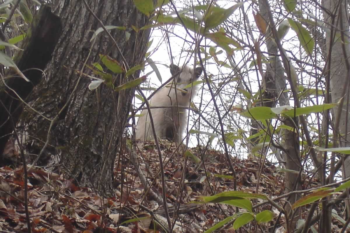
Here's a picture of a Nihon Kamoshika that my brother took just a few feet from the cache. Within about five feet of the cache there is a place that looks like the animal as made itself at home. There is a rather large area of (lets see how can I say this nicely) "poo". I looks like the Nihon Kamoshika is the type of animal that returns to the same place to do it's business.
Here's the cache: Stained Glass
-
Another place to check for cheap bowling balls is Goodwill.
-
Unfortunatly I didn't start caching until I left Yokosuka area. I lived in Hayama for almost 2 years and Ikego Housing area for about 8 months before moving to Misawa.
-
I don't really use any mapping for the caches I've done. Sometimes I'll look them up with google maps before I head out. I've found google maps has very accurate maps of Japan, but they are in Japanese. I don't know what type of software you could actually download to your GPS.
-
So far I have two caches that I've placed. I will be moving in June. If I let a local cacher adopt these or archive them does my stat of having two caches place go away?
Thanks for the help
-
Let's hear it for the 90 Toyota HILUX Surf! Great ride and handles the off-road quite well. Not quite as rugged as the old topless (and bottomless in some places
) International Scout that I learned to drive on, but a great vehicle for getting me around off road.I've got a 1991. It's a great ride although I did manage to get it stuck on the beach last week. I was driving a section that I've driven at least a dozen times before. I hit a soft spot and sunk in so the bottom of the Surf was on the sand. All four wheels were spinning. Luckly I was close enough to some very helpful people with a large tractor.
-
Coming home from a ride to Port Dover. I was mistaken in thinking that I could get some caching done on the way home from this ride. The cold and the snow do not make for a good caching experience.

Nice Bike Iron_Giant. Was that picture taken recently? If so your gas prices are low.
-
I use Track up. I also turn maps so the direction I'm heading is up and continue to turn the map as I turn. When I was in high school some of my friends made fun of me for turning the map. Since then I took a beginners orientering course and one of the first thing the instructor said to do was orient the map to your direction. So that's the way I've used my GPSr. Hope that helps.
-
lamp post cache. The cover at the base of a lamp post usually in a parking lot. Lift it up and theres the cache underneath or stuck in a magnetic holder to the underside of the bolt cover.
So you're saying that people put caches inside the wire junction area? This probably isn't a good idea. Somebody could get seriously injured if there is a nic in the wire.
-
Stand outside your house and mark a waypoint.
-
Someone might see an international symbol for first aid and go to the area of that cache if they are injured and expect to be able to get help. Both the red cross with the white background and the white cross with a green background are internationaly recognized as first aid. GC.com probably made their need's maintenance symbol so it is similar but not the same symbol. That's just my guess. Take it for what it's worth.
-
In the spring I will be caching by bike. Not in PA though. Man reading about going for a ride makes me anxious for spring.
-
I usually use the map page on my Legend. I keep the map zoomed to where the cache waypoint is close to the top edge of the screen when I'm headed directly toward it. The closer I get the more I zoom in. I've had pretty good luck with doing this (well I've found 20).
question about cachemate
in How do I...?
Posted
That was my guess, but I thought I'd ask to make sure.
Thanks