

flipflopnick
-
Posts
199 -
Joined
-
Last visited
Everything posted by flipflopnick
-
November 2010 Photo Competition
flipflopnick replied to martlakes's topic in United Kingdom and Ireland
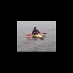
TIGG and I were canoeing on Derwentwater this month at GCTA8B. -
Repairing screen on Garmin eTrex Vista HCx
flipflopnick replied to Confused Chimp's topic in United Kingdom and Ireland
Spare rubber surrounds are possible from a shop who may have had an etrex yellow as a display model. These display models are empty. No screen no circuit board, but do have rubber band and battery springs and cover. Some of which I have used as etrex yellow is no longer made. Contact me through profile for DIY replacement rubber band. The rubber band is only held on with double sided sticky tape. So do not immerse! Rain is fine. -
Rob This is the answer. It is not the footwear. Use a Sidas footbed in all your footwear. The best money you will ever spend. Trade leader are called Superfeet. Replace the footbed in whatever footwear you use with a pair of Sidas Footbeds. The basic version will do, no need for the gel heal pad nor thermo moulded for skiers. Basic £20 version. I bought one pair. Now have one pair in all my current footwear. They turn any footwear into the most comfortable ever. All pain gone. Recommended by physioterrorists in the know. These are the posh ones with gel. When you do replace the footwear choose something with a stiffened sole. Not rigid. I have a pair of custom wellies with a Vibram sole. For caching and fell walking I have proper boots and approach shoes with proper midsoles. (Shank in old money.) Avoid metal shank from cheaper brands. HTH Nick
-
The Fred Whitton Bike Tour
flipflopnick replied to flipflopnick's topic in United Kingdom and Ireland
I was hoping people would not notice the distance and ascent involved. :-) Think of all those caches. If you look at proposed itinerary each day is less than 25 miles 40km. Distance travelled, passes ascended are dependant on which hostel is next. Day 1 Coniston to Patterdale YH only has Hawkshead hill and Kirkstone pass. ~800m of ascent 28km Kirkstone Pass is highest point on the route. Day 2 Patterdale YH to Keswick YH has Dockwray and A66 climb to Scales. ~600 m of ascent 26km (Day2a Patterdale YH to Borrowdale YH has Dockwray and A66 climb to Scales ~600m Ascent 36km) Day3 Keswick or Borrowdale to Buttermere via Honister pass. ~350m ascent 20 or 10 km Day 4 Buttermere to Ennerdale YH via Newlands Pass, Whinlatter Pass and Cogra Moss ~1300m ascent 33km (Might be better to stay at Ennerdale Bridge as Black Sail YH is very basic.) Day 5 Ennerdale to Eskdale YH via Kinniside ~400m ascent 30km Day 6 Eskdale YH to Coniston. Wrynose and Hardknott passes and Yewbank ~1000 ascent 20km All ascents are approx. We never go back to sea level. The dip between Wrynose and Hardknott is 220m Above sea level. Only climb 400m for both passes. total distance is not accurate. Day 3 and 4 could be re routed. So Borrowdale YH to Buttermere YH 10 km easy day! Day 4 is now Buttermere YH over Newlands over Whinlatter down to Lorton and then back to Buttermere YH. 24 km on route plus extra 7km to Buttermere YH Only 2 big passes. Day 5 is now Buttermere YH to Ennerdale YH 10km on route plus 7+6km getting to hostels. One major climb. Easier day before Wrynose and Hardknott. Number of caches on each leg might affect how far we get. Hmm? Very, very tentatively I might be interested. Make that a little more tentative... it's a long way from home and I don't know how I'd deal with so many hills on my bike (the bike would cope just fine, but let's just say there's scope for the rider to be a tad lighter) Breaking it into day-long chunks of 20 or so miles makes it appear less daunting -
AD180 and I went caching on Lakeland fells at night in winter a few years ago. AD180 needed to practice his night navigation using map and compass. He found the cache GZ. Head torches then found the cache. We had spare head torches and spare batteries and we told someone what we were doing with clear instructions not to call local MRT. Too embarrassing. I had an FX10 cavers halogen bulbed head torch, over 30 meters of beam for many hours. AD180 has a Petzl MYO 5 which is what local MRTs use. We went to unfamiliar areas to make it more realistic (harder). If playing at night it is sometimes worth letting the Police and Coastguard know what you are doing. Head torches on the fell can provoke a call out. Head torches on the tidal bore called out the Police. But that is another life.
-
The Fred Whitton Bike Tour is a bike ride which follows the same route as the Fred Whitton Bike Challenge which has been done in under 6 hours by local Rob Jebb. The Tour is free to enter for anyone completing the route on a bicycle. Collect a timer card in Coniston, and log your times and three check points on route. Before finishing back where you started in Coniston. fredwhittonchallenge org uk/fourseasons php As cachers we can find all the caches on route, staying in B&B or YHA on route, taking several days to complete. By diving off route to search will slow the ride down, hence the need to take several days. Start and finish timestamps are provided by South Lakeland webcam cache at Coniston. I have a Bookmark list of caches within 500m of the road on route. I am trying to develop this in to a challenge cache. If anyone is enthused by this idea I am looking at attempting the ride and staying in YHAs in April or May 2011. Start in Coniston Zero night Glenridding YHA first night (Monday Night) Either Keswick, Borrowdale YHA second night (Tuesday Night) Buttermere YHA third night (Wednesday night) Between Buttermere and Ennerdale is biggest ride with least caches. Ennerdale YHA fourth night (Thursday night) Eskdale YHA Fifth night (Friday night) This means Wrynose and Hardknott passes on a Saturday when least traffic. Coniston to finish with a webcam picture with the bikes. Eskdale and Ennerdale are clinchers. Eskdale may have to be a Friday night because groups block book during the week, and Ennerdale does not open till April. I give you this idea to complete in your own time.
-
Is there a bookmark list for cycle-able cache series?
flipflopnick replied to Delta68's topic in United Kingdom and Ireland
I am working on The Fred Whitton Bike Tour as a cache tastic bike ride. If you can get the GAGB forum to work the info is in the Days Out forum. Their forum is no where as good as this one. My opinion. I have taken Delta68's idea of challenge cache, and have started a thread in this forum. The Bog bears have an MTB Le Tour series in Kentmere, Cumbria. Can not think of a planned road bike series of caches in Cumbria. But the Smileys POST HASTE series are all roadside, and appear on Fred Whitton list. FFNick -
These are brilliant ideas. The problem I see as a cacher is stopping to seek caches for anyone on the ride. Each leg would take forever with searching for caches. Some caches on route are cache and dash, some are a little further away. An event cache at the end, maybe. And a challenge cache to find after some qualifying finds.
-
October 2010 Photo Competition
flipflopnick replied to keehotee's topic in United Kingdom and Ireland
Most of my photos are used for Waymarking but here is GC photo taken earlier in the year. from a log As an ardent Waymarker I go armed with a good camera. Here is a picture grabbed in a heavy shower of a Bamford's No 4 Water pump. Nearest cache was Spika Coppice. FFNick -
The Fred Whitton Bike Tour is a bike ride following the route used by the one day challenge, but done in your time over several days if wanted. Collect a timer card in Coniston, Cumbria at the start. Dib the card in three other check points along the route before finishing back at Coniston. Free to do the bike tour. http://www.fredwhittonchallenge.org.uk/fourseasons.php My idea would be to find all caches within 500 m of the route. Taking several days on a bicycle, staying in YHA or B&B. As cachers we could log our start and finish on Coniston webcam. I have created a bookmark list of the route. http://www.geocaching.com/bookmarks/view.a...61-22fc4a9390ef But how to turn this into an event cache or a trad cache or a multi cache? Realise not everyone will use a bike. Any suggestions?
-
Meant to say long ago that Fujitsu-Siemens Pocket Look N520 running WM5, player works fine. Usng Port Splitter to share COM port.
-
Sad news - Billy Twigger
flipflopnick replied to Firth of Forth's topic in United Kingdom and Ireland
I met Ewan only once. But he left a memorable impression. So much so when publishing a cache I always put parking info for Ewan. Recently went for some of his hides. My thoughts are with his family. -
Pda/Memorymap problems
flipflopnick replied to Lorri-Ann & Kev's topic in United Kingdom and Ireland
I phoned EVO distribution who import MMap into UK after they ignored emails. They are useless and unable to help. Apparently MMap know their app does not install on all PDAs. MMap should be installed to PDA memory, preferably. But if your PDA loses everything due to volatile memory, ie it does not have static memory, copy MMap folder to card storage as a backup for use in the field. Then copy back when it all goes pear shaped in the field. As mentioned above, maps are stored on card in another folder if available. If MMap won't work on your PDA it is because of a failed install, and you have to manually add certain files to the MMap folder. There should more than one. I have not found out which files those are. Apparently this has been discussed elsewhere on the internet, prolifically. I am now searching these forums. One tack I will try is to copy someone else's working PDA install of MMap to mine. Like you I have gone paperless (with GPS enabled WM5 Loox). In meantime use a wonderful freeware app for Windows Mobile PDA called GPSMap-OS. To use take a screen grab on Desktop MMap showing caches. Paste screengrab into graphics app like Irfanview.com save with name of cache or area as PNG or JPEG drag map picture onto PDA into MAP folder on card, using ActiveSync calibrate map in GPSmap-OS. go caching. If I'd known about GPSmap-OS I would not have wasted money on MMap. Maps are also available for free from OS. Only 3km 1:25,000 squares using their Getamap service. Join together for larger area or grab several. Google for answers and locations. Please contact me thru my profile for more on GPSmap-OS. Another moving map app is TrustGPS. TGPS Hmm -
I agree it can be a driving challenge that can irritate locals at the drop off points. Why not make a different challenge? We are after all cachers. Make this a multi, perhaps. Visit 3 peak caches in your own time to find a 4th cache. The peaks may not be the usual highest points, but 3 other caching peaks. The remotest cache in UK, the highest UK cache and the lowest, perhaps. Log the multi with evidence of visiting the qualifiers. see NineSquared Now that's a challenge I'd rise to. Might take years.
-
I use GPSTurbo on PocketPC. Very good. Tricky bit is to name the map section correctly for moving map display. On Windows Mobile device GPST lacks a pointer like a hand held GPSr has, or am I missing something. I have not tried Memory-map nor GSAK on Linux. Instead I have to dual boot Ubuntu and XP.
-
LAT.- LONG. to UK GRID REF'S - CONVERSION
flipflopnick replied to gansonwheels's topic in United Kingdom and Ireland
OS have a spreadsheet on their site. http://benchmarks.ordnancesurvey.co.uk/ In Quest provide a Windows batch convertor. Spreadsheet of use in the field if you have PocketPC or Palm PDA. In the field easiest to use your GPSr. There are several PocketPC and Palm free programs to convert. Be aware each method that converts OS to Lat Lon will give different results. They all use slightly different algorithm. OS grid ref describes a square, not a point. Lat Lon varies depending on Moon's distortion of Earth's surface. But for caching we only need to get within a few feet. So good enough. Each coord system uses a different datum. More errors. OS used OSGB36. Groundspeak use WGS84. Your GPSr will preselect correct datum and do the conversion for you in the field. NB Memory-map in UK use WGS84 throughout, leading to erroneous coords when converting between OS and Lat Lon So with multi, which datum has the setter used with which coord system? More apprehension. In the field with a multi, change the settings in your GPSr, if you can remember how from Lat Lon to OS and back. Takes seconds if you can recollect. Take a crib sheet with you. Why? Try finding a disused OS rivet using coords with an archaic different datum. It may or may not be there. Oh its 2 cm wide and dark coloured. Probably no one has visited it in 30 years. The surveyor's notes are like a Hint except in text speak. -
What is your most valuable, or favorite Geocache Gadget ?
flipflopnick replied to yawppy's topic in General geocaching topics
The reason for this post is to see what kinda gadgets you have , ones you probably would not have if it were not for caching, whats the craziest, whats the best, whats the worst of the caching gadget, or equipment? Caching Only gadget is PocketPC with built in GPSr for Wherigo caches. One month old. Prior to that bought Palm M515 for Waymarking and paperless caching. Palm now running Novii Remote used exclusively to control TV/DTV/sounds. Craziest caching thing are friends who don't understand that a christening/birthday/wedding/family-get-together miles away are all caching opportunities in new territories. Worst caching gadget is a computer printer that uses paper. Paper is pants. Paperless is powerful. Second most useless gadget is a PocketPC. 1) because of M$ Active Sunc is so flaky. 2) Nearest Wherigo cache is 65 miles away. http://forums.Groundspeak.com/GC/style_ima...icons/icon7.gif Best is premium membership. Opens up caching to a whole new level of involvement. Without that all gadgets are under utilised. Second best is trustworthy etrex. Works every time. Reliable. All you need apart from a pencil for micros. -
Using Fujitsu Siemens PocketPC LOOX N520 running WM5 with internal GPS. MUST turn off IR receive first before GPS will work. As on same hardware 'channel'.
-
1 Is any other program running that accesses COM ports? eg Palm Hotsync, Memory-Map If so quit that program. to stop Init error 2 USB to serial lead from Memory-map for eTrex range needs setting to COM5 in MMap not USB. Many USB to serial convertors don't work with GPSrs. Don't know why. Many have tried. If desktop computer, fit PCI serial card. If laptop, try PCMCIA serial card. These are cheap solutions.
-
Someone DNF a webcam cache!! How can you do that? Here's their log. Made me chuckle.
-
Xp and my M505 play well together. With Cachemate & GSAK it makes a good combo. ahhhh....great....that's what i was hoping to hear....after some reading i've noticed that a LOT of people are having trouble hot-syncing the 505 using XP....what did you do to get around that problem? Also, I use GSAK, but not cachemate...can the info from GSAK be sent to the m505.....if it can, what are the advantages of using cachemate....also, is cachemate free software? Thanks for your time. My xp works fine with GSAK 6, Palm desktop 4 and M515 and Zire71. Cachemate is $8, GSAK is worth paying for, and you will appreciate Premiun membership of Geocaching to build Pocket Queries. It takes seconds to generate a Palm bundle in GSAK, and sync to M515. Whilst thats syncing, upload coords to GPS. People probably need to install USB drivers for PALM. NOT use XP's own. Search the forums for paperless. A new battery is very cheap for Palm M500 series.
-
You did not hear this from me :-) Its possible to copy the SD cards. They are not tied to each device, unlike Garmin maps. Re-inserting the SD map card whilst switched on, alerts the active 10 to cards presence. OS mapping back on track. Going into Mickleden today to find a Geovexilla flag with active 10. oops wrong forum!! Have asked Satmap to recommend a waypoint program. Heard nothing back yet.
-
There appears to be no way to put in coordinates. Not found a way of connecting it to any GPS software I've got. But the display is bright enough to light the way at night. Too bright. Might be worth waiting for Clyde at GSAK to develop an export feature or other mapping software to work with it. Will report back after further use. The SD card I got does not work, so can't report on the OS mapping. But road mapping works. Have not found out how to play mp3s, yet. Running on lithium batteries because its cold out there.
-
If anyone is wanting to search for all caches in Cumbria. Dunno why? Try a 33 mile radius search centred on Harrop Tarn cache. It will pull in a few in North Lancashire and some across the border of eastern Cumbria. A few north of Carlisle may get missed, but all caches in Cumbria will be included (592). Maybe move centre up a few miles or increase radius to 35 to be sure to get all. Anyway here is link for Harrop Tarn 33 mile radius search http://www.geocaching.com/seek/nearest.asp...;submit3=Search Saved it as a PQ, but using coords for Harrop Tarn on search page also works. Used decimal coords of Decimal 54.51445 -3.06873 and set radius to 33 mile. Maybe someone else will find it useful.