

Ernmark
-
Posts
533 -
Joined
-
Last visited
Everything posted by Ernmark
-
Awesome! I had also considered looking for Soper &/or Stabler instead, but took a guess that Webb had the best chance of being intact & I only had a few hours to hunt that day - I'm glad I chose to look for Webb.
-
My favorite time to ascend the mountains is Late March or Early April - warmer, but before the leaves/ticks/poison ivy are in full force & you can still get a decent satellite lock. ...maybe we could even cajole PFF to cross the Potomac for this one!
-
Papa Bear - thanks for the link - I'd forgotton about your maps...I'll get to work on more sites down there as the shopping trips allow I'd also like to get to MARYLAND HEIGHTS S (JV4626)- BDT, want to meet up & give it another shot? (from the looks of the terrain, there should be at least a half dozen of us searching!) Klemmer & TeddyBearMama - This dosen't have a whole lot of relevance to your question posed above, but but I was pleased to see the Google Earth registration was about spot-on!
-
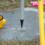
I was going to post a reply to Papa-Bear-NYC's EOA thread on the Epping Base Line , but thought it would be better to have a separate thread broken into the parts listed on Holograph's wiki. Papa-Bear had stated the desire to keep track of EOA recoveries, so I will add mine: Unfortunately this won't be a very exciting story as there was no mountain to climb or serious measuring - however, it was nice to get a chance to look for one of these stations. The 'Mizziz' wanted to go on a shopping junket in the Baltimore-Washington area & I found myself about 5 miles from WEBB (JV5810)...so I charted a course to hunt for BMs toward that direction. After warming up with a few benchmarks along the way, I found the most difficult part of the search was getting access to the area. Fortunately, the station is located on county government property & there were a few workers on-site at the property who explained the best way to get there – I would not have searched otherwise as the property is posted. I had hoped to be able to find the original referenced stone markers placed 5 feet (more or less) to the E, N, & , S of the main station, but they were not visible – due apparently to a mound placed around the monument, most likely in 1933, when familiar USC&GS bronze disk were set. Per the (2nd) 1933 recovery – “SUBSURFACE MARK A CONE BURIED 1.7 FEET BELOW THE SURFACE WAS RECOVERED AND A TRIANGULATION MARK CEMENTED INTO THIS CONE BY MEANS OF A PLUMBING BENCH AND A SURFACE MARK WAS ALSO SET BEING SEPARATED FROM THE SUBSURFACE MARK AND PLUMBED OVER THE SUBSURFACE MARK” By 1942 the original reference posts were not found. surface mark (close up was too blurry to use - I was either too excited or didn't have enough light) setting showing mound which probably covers reference stones Although this was not a 'hard find', it was interesting interpreting the old references to plot the location of the station in relation to the old driveway (houses are long gone) and what appears to be an old yard fence. I also found an interesting stone (actually the first thing I found when arriving at the site) which appears to have been used at least - at some point - for surveying purposes...it looks like there was a cross chiseled on the top..although it isn't referenced in the datasheet. ? well...maybe not the most exciting old recovery (even for me)...but it was still more fun than pouting in a shopping mall! - E
-
..at least I have more time to catch up on my NGS backlog As for the mystery of FX1352 - I think I remember a story from the Jan 3rd issue of the Cary News Gazette - Local Benchmark Hunter lost in woods - returns 4 years later after making recovery.
-
..we've had some mini-quakes here in Central PA lately. Great - The drive to the Jersey Shore already takes 4 hours..now if PA & NJ start drifting apart...!
-
..best dam recoveries I've seen for a while !
-
I did a treatise on the next stage back in 2006. See this thread - quite scary!
-
Problem with Magellan Explorist 100
Ernmark replied to bonaccord's topic in GPS technology and devices
..one thing - if you had WAAS before, the reset will cause you to lose it because of the new satellites....but if you're 350' off before the reset & you can get back to the right few meters, it is worth the tradeoff. -
I'm happy w/ the results of the 2.57 EU firmware (+ the additional screens) - the performance overall seemed to improve. I'm curious as to whether those 'new' screens are part of these new NA upgrades - has anybody taken the leap yet?
-
Problem with Magellan Explorist 100
Ernmark replied to bonaccord's topic in GPS technology and devices
...have you tried clearing the memory & restarting? -
..I've had similar experiences - an old line near me was decommissioned in the 70s that had some disks & a lot of rivets. A number of the rivets were reported as NF by the USE during the 50s. Ex: KW1978 KW1979 KW1981 All were easily found - and I had no trains to worry about! (I wonder if the USE NFs were actually 'not searched fors') The disks that are smattered here & there along the same RR line appeared to have been ignored by the USE in 1952, even though the disks were set in the 30s. It may be that the recovery parties were only interested in recovering a certain 'string' of marks when traveling thru an area (or only have/had that info w/ them). So by all means, they could be there. And be mindful of PFF's warning about the trains!
-
Don't beat yerself up too much - it's still a killer app!
-
Here's an 'unusua'l one from the Benchmark Gallery: X 211 (HT1496) by batch218 (...did the whole NGS party return from the last recovery?)
-
To echo Paul's comments, I too keep my 'raw' photos elsewhere & manipulate the BM photos stored in another location (in my case a USB drive). Thus far, I have only submitted pics to NGS to document 'destroyed' marks, so I don't have to worry too often about the NGS-specific format. I organize my photos by date, followed by the name of the area I searched in, such as 'Baltimore' or 'Adams County' Regarding the RR question, there are a number of threads about that. On at least 1 pic, I made sure not to have a 'no tresspassing' sign in the area photo. I do try to be respectful & llimit any 'incursion' to the minimum needed to access the disk.
-
Here's text I had found before on NGS's site: How to submit digitial photographs to NGS: Take 3 photos if possible, one close-up showing mark with stamping visible, one showing the entire monument, and one showing any nearby witness features to aid in identifying the location, and any significant obstructions to satellite visibility. Detailed guidelines are also available at: http://www.ngs.noaa.gov/PROJECTS/INSTRUCTI...equirements.pdf
-
I think Paul went out today to bag FB2910, so I'll give this one a shot. NGS recommends for photos: 1 - disk shot w/ stamping legible (a dusting of cornstarch, baby powder, or chalk helps when the stamping is hard to read) 2 - shot of the disk from eye level showing nearby references (indicate the direction you're facing) 3 - area shot w/ disk (or notebook, cone, shovel marking it if not visible) in view - again indicating the direction you're facing. NGS also has suggested formats for file names (I have the link bookmarked on another computer - someone here can post the details) for GC logs, there is no hard/fast rule on naming, but a lot of us will post: for Pic 1 - DISK NAME, PID, City or County & State for Pic 2 - DISK NAME, &/or PID, 'setting' - facing NW, S, NE, etc for Pic 3 - DISK NAME, &/or PIV, 'area' - facing NW, S, NE, etc Sometimes only 2 pics are posted on gc, depending on the references, etc. Also for pics, I'll keep the camera on the lowest pixel setting (mine is 0.3mp which yields shots from 75-125k) to facilitate uploading. (If I run into really nice scenery, the photo buff in me kicks in & I'll take additional hi-rez shots for myself!) As for storage capacity, I put most of my pics on a USB flash drive after I organize them - they're getting pretty cheap these days. - Eric
-
..SOMEone's gotta ask: is that your chair? At any rate, sure beats the view from my chair!
-
On June 17, 2004 - BDT posted unto the Forums the following text (also known as topic 73525): "Some benchmark pictures are really excellent! Sometimes I "set as background" one for my computer for a while, until I find another really good one. I propose a thread here for posting really good benchmark pictures, either your own or someone else's. Contest rules: (yeah I know, I'm always proposing so many rules; ... anyway...) 1. No intersection stations (the station IS the tower, building, etc.) Why? Well they all look pretty good, but they're not really all that 'benchmarky'. 2. The disk has to be at least vaguely visible in the picture. No - 'view from', 'the area', etc. with no PID marker in it. Why? It's gotta be a Benchmark picture! 3. It has to be a PID in the database, or at least one of its reference marks or its azimuth mark (in case they don't have their own PID). 4. No closeup of just the disk. (Come on, it's just a disk - where's the nice scenery?)" And in keeping up this great yearly tradition, I'd like have the honor of kicking off another great year of hunts, finds, & info (and of course photos) by starting this 2009 thread - also, in the tradition of pulling pictures from the gallery that were taken by other benchmarkers .....I submit the first picture - a nice seasonal photo by our own Harry Dolphin: KV4911 WATNONG 2 (RM2) Special thanks to the Dolphin for freezing his fins off to bring this picture to us while we sit inside w/ our computer & beverage! Edit (1st of 2009) to add Dolphin lingo to above sentence.
-
It's a bit subjective - if the coordinares are far enough off that you believe that it will help someone's search - i.e. flush w/ the ground in a desolate field, in the middle of a field strewn w/ like-sized boulders, in a city but 2 blocks off (watch for multipath error) - then I'd add. Here's an example: NGS Recovery - J 161 (JV2063) (being anal retentive, I should've put the 'N' & 'W' in ( )'s Geo Log - J 161 (JV2063) (speaking of anal retentive - I've got a spelling error to fix) Anyway - this one VEX'd me for over a year - 3 biiig boulders, but no disk on top of any one of them. Finally found it on a low 'rock' near the nortnernmost boulder: ..not the first place I'd've looked - the big boulder has a nice flat surface! (My other visits were when vegetation [mostly poison ivy] was in full disk-covering glory). Actually the addition to to the description is probably more useful in this case, but I added the coords to help zero in for the person that will have to brave the weeds in July! (The scaled coordinates are about 100' to the SE - closer to a different boulder - so given that + the original description, someone in a hurry may have went off looking for another mark)
-
...I was hoping ArtMan would come up to PA to help w/ my excavation project - I'm closer!
-
Most of the time I've reported them, I'd say the scaled coords were off by at least 100'. I also take into account listed references - if it's the only 10-foot high boulder in the area, I'd probably not bother. If I think it will help someone who needs to actually use the mark, I'll add the HH2 coords (in NGS-used format) & any updates to the references that should help. I try to keep in mind that, while it's fun to look at 'stats', as far as reporting to NGS is concerned, we're in a professional database..and one where our mistakes will stick [gulp] for years
-
..any luck getting a 'PFF' agency radio button on the recovery form? [full-bellied chuckle] Back on topic - you guys are gonna force me to go dig up the tri-station with no remaining RMs that's in a wheatfield 24" deep so I can finish my home county, aren't you?!
-
Wow - that's where a good 'to reach' description sure would come in handy!
-
..I've tried both - I'm gonna have to go w/ snow on this one* *especially if it is less than 6" - otherwise my metal detector won't find the disk!