

Ernmark
-
Posts
533 -
Joined
-
Last visited
Posts posted by Ernmark
-
-
In a related note - I've begun to notice that paper maps in general (i.e. traditional highway maps & street maps) are getting hard to come by. When I travel on vacation, etc., I used to always try to pick up a street map of the area I was visiting in order to get an idea of the 'lay of the land' but in mini-marts, gas stations, etc. the pickings are getting slim. GPS units are great, but there is a lot to miss by not knowing anything about the area more than a hundred yards left or right!
-
..does this make the Scaredycat Benchmark viewer the most accurate source of geospatial reference information?
Awesome! The mantle of information rests upon you, my friend!
-
"Sorry folks, park's closed. Moose out front shoulda told ya. "

"it's a quest! A quest for fun...."
...oops - thread hijack!
-
..NOW the Gov't shutdown has my attention!

-
It's back - woohoo!!!
-
Speaking of the viewer - is anyone having trouble with it today? I haven't ben able to access the site since sometime last night. I must admit, I've become quite dependent on it

-
Sad news - he was a well-known name to benchmark hunters over at Geocaching.com as well..
-
Thanks. Myself, I find it rather creepy that I call this decade-old stuff up from memory, when half the time I can't remember where I left my phone....
..happens to me, too - I believe it has something to do with the 'Early Onset of Old Age' !
-
I looked over @ Waymarking & nobody's posted this one in the US Benchmarks category, if you're inclined to post there..
-
The alternate coordinates that were posted are spot on for the RM which is consistent with the bogus finds. Projecting a back bearing from the RM comes up with the coordinates listed on the webpage. All good and fine so far since the page clearly says the mark is 3" subsurface which explains why no one has actually found it yet. The real problem lies in that it seems the rock that the RM is monumented seems to have been rotated. The arrow on the disk is pointing almost due north.
The most important thing is that the station has adjusted horizontal coordinates. A quick sweep with a metal detector in the 'sweet spot' should yield a hit if the mark is still pretty close to the surface..
-
I mean, if I go to the marker next week, and the thing hasn't been replaced, how do I report it as? Mark Destroyed, Mark Mot Found, Poor?
NGS reported to us about 5 years ago that they really weren't interested in recovery reports for intersection stations (spires, poles, etc). If you were to report this one to NGS you would either report a 'not found' in the standard recovery form (with description of what you observed) or take a photo of the area with pole missing & email to Deb Brown @ NGS, where it would be reviewed to change status to 'Destroyed'.
Here's the instructions from the acutal Recovery form:
1) If you have found the actual marker separated from its setting, you can report the point as destroyed. To do so please send the report on the destroyed mark as an email to Deb Brown (Deb.Brown@noaa.gov). If you send this email, please do not submit the current form, Deb Brown will submit the report for you. In addition, please submit proof of the mark's destruction via actual disk, rubbing, photo, or digital picture (preferred) to Deb Brown:
Deb Brown, N/NGS143
National Geodetic Survey, NOAA
1315 East West Highway
Silver Spring, MD 20910
2) If you did not find the actual marker, then you should enter notes concerning evidence of its possible destruction as text records and select "Not recovered, not found" as the condition of mark.
-
I am looking for this benchmark, MARION with the box score as follows. I have found the reference mark, which is all any one has really found. When reading the box score do I follow the bearing straight down from above? In this case, the benchmark should be on a bearing of 324° 03' 00.0" from the reference mark?

The Box Score bearing would be from the actual station MARION (true north) - so you would subtract 180° to do the reverse - 144° 03' if my math is on target today

- edit - looking @ Google Earth, the main stastion should be SE of the Reference Mark - maybe 5' W of a pole & across from the driveway.. see map
-
Not sure why both are 'Destroyed' - however, I wouldn't report a good recovery on SK0181(the bolt) without actually seing it.
Interesting result when typing in SK0183...
-
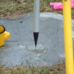
Found this one a few days ago. (F 559 1957)
The station I found was slightly tilted. When I returned home I noticed another logger has a F 559 RESET 1979 photo, which must have been nearby. The odd bit is there's no RESET in any of the lists I have and there's no comment the station was reset.
..think it might be H 559 RESET in the pic?
AA4342 STATION DESCRIPTION
AA4342
AA4342'DESCRIBED BY CALTRANS 1979 (CML)
AA4342'0.8 MILE (1.3 KM) EAST ALONG STATE HIGHWAY 58 FROM THE CALIFORNIA
AA4342'DEPARTMENT OF TRANSPORTATION MAINTENANCE STATION IN SIMMLER, 0.25 MILE
AA4342'(0.40 KM) EAST OF A RANCH HOUSE, 40 1/2 FEET NORTH OF THE CENTERLINE
AA4342'OF THE HIGHWAY, 0.5 FOOT (15.2 CM) SOUTH OF A FENCE, 1.0 FOOT (0.3 M)
AA4342'SOUTH OF A WITNESS POST, 0.9 FOOT (27.4 CM) HIGHER THAN THE HIGHWAY,
AA4342'AND SET IN THE TOP OF A CONCRETE POST PROJECTING 0.5 FOOT (15.2 CM)
AA4342'ABOVE THE GROUND.
-
I do believe I have found some benchmarks in Bermuda on the Old American Military Base
I know we're off-topic, but....do you have any photos? I know of some Tidal Benchmarks I'd like to look for when I get back there again..
-
>>>>>>>>>>>>>>>>>>>>>>>>>>>>>>>>>>>>>>>>>>>>>>>>>>>>>>>>>>>>>>>>>>>
My main concern is about logging. I hadn't considered letting the user log directly to NGS, but I suppose that's a possibility. (The submission form is at http://www.ngs.noaa.gov/ngs-cgi-bin/recvy_entry_www.prl, in case anyone hasn't seen it.)
I know people typically log to geocaching.com. >>>>>>>>>>>>>>>>>>>>>>>>>>>>>>>>>>>>>>>>>>>
>>>>>>>>>>>>>>>>>>>>>>>>>>>>>>>>>>>>>>>>>>>>>>>>>>
Vince
Vince,
I can't find a previous forum thread right now, but it is generally expected that a new benchmarker log quite a few marks into Geocache and then be very familiar with the above 'pinned' topics before attempting an official 'RECOVERY' with NGS.
Please note the emphasis I placed on the terms 'log' (what we do to report on our hobby activity), and 'RECOVERY' (information -hopefully not misinformation - which becomes part of an official document that can be very important to professionals in the field of surveying and engineering).
And there are a smattering of NGS marks that are physically located north of the Medicine Line.
kayakbird
Agreed - NGS recoveries are going into a database which is meant to be used by professionals, and you will often want to include updated descriptions, measuerments, etc. I've always wanted to review whatever notes I've taken & look over my photos before submitting an official recovery....not to mention that typing on those little phone screens seem to allow me to make mistakes
-
Are there boundary stones for the MD-DE lines?
Sure are - here's the first one: BOUNDARY MON INITIAL DE MD (HU1443).
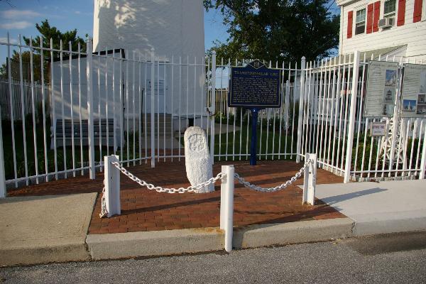
Seventhings visited quite a few of them awhile back & posted them with a lot of accompanying research on Waymarking - Ex: TP Line Mile 0, 1751, Delaware-Maryland
-
There seems to be a lot of fresh marks on the Eastern Shore to look for once you get settled in!
-
I don't think so - there were a huge amount of marks set during the war (especially in 1942)...
-
I look forward to seeing him show up in the BM hunting statistics over @ holoscenes.com !
-
I believe that is it - the 'Hippo' list
Thanks!
-
Does enybody know off-hand the current location of NGS's list of monumentation types? (formerly - www.ngs.noaa.gov/PC_PROD/DDPROC4.XX/dformat.documentation.html#A.12 ) Thanks!
-
Most of the BM's i've found aren't in the Geocaching outdated database (using primarily the Scaredy Cat Film BM Viewer to find the ones not listed by Geocaching). So, I don't think i'd be justified in reporting that I found the mark via Geocaching. And to be honest, i've gone to that as default with BM's that i've found via Geocaching via force of habit.
GEOCAC is just another 'agency' listed in the NGS database like State Highway Departments, State Geodetic Survey, US Power Squadron, etc. GEOCAC was set up for 'us' as a group to submit our findings, and, as stated, individually we can be identified in www.holoscenes.com if you like to keep track.
PS - we don't mention it a lot here, but there are other cool things if you poke around the site - including a BM Wiki!
-
It's been reported elsewhere here that NGS uploads have been spotty lately. Interestingly, the last example you linked to (TU0858) has an incorrect recovery - the reset disk is a different disk altogether, so J 22 is 'Not Found'.
NOAA Says No More Paper Maps Of US Waterways
in Benchmarking
Posted
..so I'm not the only one! I have a few really old official highway maps (pre WWII) - no Interstates, US Highway numbers* gone for 50 years - a different world!
* some referenced in NGS monumentation info