


Rumpled
-
Posts
104 -
Joined
-
Last visited
Posts posted by Rumpled
-
-
I'm pretty sure I would have found it here or a link to it from here.
I tried searching, but the search wants five letters, leaving out topo and kml.
Anyone know or remember where the link was for the kml that adds the topo overlay to GE?
Thanks
-
As I live in a desert, I've not encountered too much of this.
For the first picture, I might try skirting to the left; either in my 4x4 truck or on foot. Depending upon water depth, which is difficult to tell from pic.
For pic #2, I'd try to skirt either treeline where it might be a bit drier. Or sandals it straight up the middle.
I do a fair bit of trail running, and I typically just storm on thru any water and hose my shoes off later.
-
Could someone possibly link to or imbed the photos here?
-
I'm having a similar problem. I have a route query set to 3.11 miles and 250 either side. It only yields 28 caches on the preview and the "cloud" map of the route has returned to the world map after modifying. No filters were checked.
This is in a very cache dense area and should yield hundreds of caches.
I also wish those slider inputs could be done numerically.
-
Thanks all for the info.
I have no current plans to go to Mex; but if I do - looks like I've got help.
-
I'll give it a go.
I haven't found many BM's recently and not too many setting types overall.
We'll see how it goes.
-
Lucky !*%@^% to live so close to that!
HEY, you guys qualify for all four of my Benchmark Challenge caches!
Come and get 'em!
So, what is this challenge?
-
Great trip success and report. Reading your logs, I think it'd be good if you expanded a bit like you've done here. It would add to future viewers' appreciation.
In my log of HR0808 on O'Shaughnessy Dam at Hetch Hetchy, I wrote
"Setting: light structures
Stability: Mark of questionable or unknown stability"
I truly hope not - it's set into a dam that's 900 feet wide and 300+ feet tall.
I know that it will probably be breached in a few millenia (if not torn down); but I generally consider it a stable, heavy structure. Very similar to the situation here.
I notice that Klemmer and Wintertime have also visited this one.
-
Didn't I say to back up your own basemap? You only have yourself to blame.
Yes, I could not back it up. Yes, agreed.
Published firmware on that web site might make Magellan Lawyers try to shut down that site. Just like they have shut down many sites that have ever posted basemaps. There are some people who have many basemaps. I have many and might send you one, but I need to know what that filename was on your Green/Yellow which you thought was a Gold (any why do you mention Platinum which is the only unit with a Compass?)
I don't know what basemap filename I had. I believe that if Magellan won't support us, then supporting each other is good. I have two Meridians - a Platinum and a Yellow that until two days ago I thought was a Gold.
WHAT UNIT DO YOU NEED A BASEMAP FOR? Everyone else who might want to help you needs to know the truth.
I thought I clearly stated what unit I needed a basemap for. On my Yellow, when the basemap was lost on a stuck upload and I finally got the unit powered up again; it would not funcition and was stuck on an invalid basemap page. Once I got it working with the EU basemap, my topo detail maps worked fine.
I was given a tip on where to find a North American basemap that works.
Thanks to everyone for their help - I now have two working WAAS enabled Meridians.
-
I didn't even have to open up a hex file. Over at the Yahoo Meridian group there are fixed files to download. It basically took me all night last night; but I got the WAAS situation fixed. I did have to do the clear all memory, initialize and calibrate the compass on the Plati.
What I thought was a Gold is actually a Yellow - I ended up crashing it about four times and really thought I had bricked it.
I ended up losing the base map and the only one I could find online was the European basemap.
If anyone knows where to find or has the Green/Yellow 2meg basemap -I'd really appreciate it.
-
I've done a fair number by bike.
On some power trails it's almost annoying to stop every 528 feet to get a cache, hardly build up a rythym

Since I've found a good number near my house, by biking from home I find my rides to be longer and longer; with fewer "incentives" closer to the house.
The bike itself can be a muggle deflection tool. Just pretend to adjust something or take a water break or whatever.
-
As the owner of a Gold and a Plat; I've got a little work to do.
I think I need to update the Gold's firmware anyways, it's my little used backup/kid's unit.
So, if I've got this right; all I really need to do is change about 4 characters in the firmware? (skipping the longitudes)
ie this part
So you can change the 7A to 87 and the 86 to 8A
-
I understand Earthcache requirements for getting landowner permission. But, when it comes to the powers that be; all you are doing is making something of a online guidebook. Does everyone who posts info online for parks or who writes books or trailguides get permission to do so from NPS.
It seems a bit much to me; especially paying for a permit to tell people to pay an admission fee to a park to do the normal touristy things.
-
I'll be another to move off topic.
I haven't heard of the Old or New or New/Old parts of the Nut Tree - I haven't been there in over 20 years.
When I was a kid in the Bay Area my father would venture to Reno a lot on Army Reserve Duty. He would always stop and buy us gingerbread men from Nut Tree. Fond memories of that.
So, with the new and old etc I suppose it's had development like my other favorite roadside stand turned into a near mega corporation - Casa de Fruta.
I've got two Magellan Meridians, a gold and a platinum. I'll have to check into andy WASS problems.
-
My wife and kid are into pins big.
I go along for the ride as they go along for the BM'ing ride.
I'll have to grab one of these.
-
Actually, I couldn't find any photos that I took of a bearing tree.
But, I know where that one is and should see it again in August.
-
I'll have to check my records to check my records. I found and photographed a bearing tree while camping near Big Bear Lake, CA this past August.
I didn't search around for any other markers, though.
If I have coords, I'll waymark it.
-
I think this might be a new one
Southern California Edison Company
On a recent trip to Laughlin I happened upon this one and waymarked it
Currently waiting on approval; I'm assuming it'll be Black Dog Trackers approving it again - maybe you can create a new agency for me? I think that might be the third or fourth new agency I've needed over there.
Looking at the text stamped
RLS 7
2050
POL
Which is the designator? I'm kinda assuming RLS 2050 is the surveyor; so either POL or 7 would be the designator - I think 7
Well, here's the pic
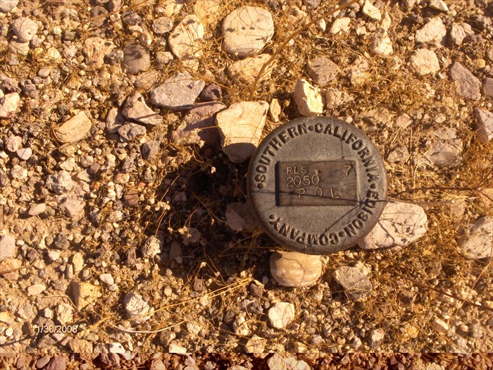
And the waymark link
-
In a hiking forum a picture was posted of a section monument about a foot high or so that has four sections listed on four sides, but it is not at that location.
Here's the original thread, it's about halfway down page 3; couldn't figure out how to post a single post. Credit to HikeUp, Matt and Hikin' Jim for the pics and maps
Any ideas why someone would go to the trouble of making the monument and putting it about a mile away?
Here's the monument

From the thread about it I got these coord off a map
N 34 16.031 W 118 16.550 more or less
Searching NGS dataheet retrieval finds nothing within 1.4 miles, and nothing that seems it would be this section marker in the spot it's in or where the sections meet.
The marker is at "C" in this map and the sections meet to the east at "G"
Another marker shown is Random Point. That's a good name.

So, any theories? My guess is that the marker was made and not used and then used elsewhere. That, or somone went to a lot of trouble to move it.
-
I've always wanted to try skijouring with my labs; but alas my older is 11 now and has arthritis.
I would be a bit afraid they'd pull me too fast; I've tried taking them along as I bike, but they pull too fast for me to ride if on the leash.
Off the leash it's great; and I've gotten them up to about 18 mph for a short stretch - they could hold 12 for awhile.
When in the snow with saucers, my chocolate will carry them back up the hill for people. He just thinks they are big frisbees.
Well, enough of dogs - they haven't taken any good pictures of benchmarks recently.
-
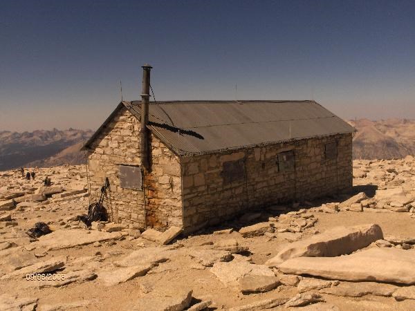
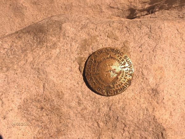
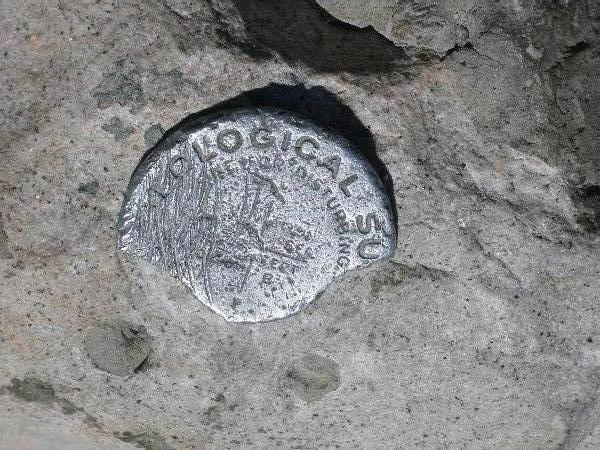
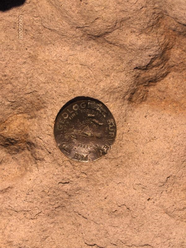
OK, here goes my report on the highest survey markers in the contintental U.S.
My hike to Mt Whitney.
It's the highest point in the continental United States; California; Inyo and Tulare Counties.
That makes these the highest possible benchmarks in the kiwer 48.
The elevation has been at various times reported between 14494 to 14505. I'm going with the highest myself.
Here's my trip experience.
Wow, this was one tough hike. My friends and I spent the night at Trail Camp and then summitted on this Saturday, Sept 6th. . We had hoped to downhike all the way down on the same day, but we were so bushed that we stayed at Trail Camp another night. A wise decision it turned out.
On the summit, all I wanted to do was go back down. I was feeling horrible, good sized headache and breathing hard. I got some real cursory pictures, signed the summit register (another waymakr to create) and looked at a couple of the benchmarks. Before heading down; I looked for the physical geocache up here; but only give it a minute and a half or so and retreated to lower elevations.
The weather couldn't haven't been any better. It didn't get below freezing, too hot, or have any precipitation the whole time. And barely a breeze at any time - no winds to speak of.
Now that I'm back near sea level, I can run over my photos and evaluate the summit markers. I made no measurements at the summit; I'm going with the assumption that they are all were the real surveyors said they were - altitude included. This high up it's just not right to call it elevation, we were at altitude! The ceiling for some small planes is below this level!
Here are the GC listed BM's for the summit massif. I'm using the datasheets from GC. Maybe not the most current. I did check GT1811 and 1992 is the current datasheet.
GT1811 Whitney 1950 This is the main station for the mountain. 1992 VERTCON of 14505 feet
This is the Big Kahuna. It is the main station and the highest VERTCON at 14505 feet.
The horrible thing here is that it is the only remaining mark that I did NOT recover.
I'm a bit bummed by that.

GT1812 Mt Whitney Cairn Reported as destroyed by 1962 Scaled 14505 feet
Everyone logging this one is wrong.
GT0238 K72 1992 VERTCON 14499.2 feet
I did recover this one.
GT1808 Mt Whitney Smithsonian House Scaled 14505 feet
Easiest recovery there, who can't see a building? This is now 99 years old. This is obviously ~20-30 feet lower than station marks.
GT0239 U43 1992 VERTCON 14499.6 feet
I did recover this one
GT1809 Plaque Near Whitney Scaled 14508 feet
Been missing since at least 1962. Everyone logging this is wrong. The plaque there now is not this one.
GT1810 14502 Scaled 14508 feet
Only about 2/3 of the marker is there. In my photo I could make out the 502 barely. Slightly questionable recovery here.
GT0237 14501 1986 VERTCON 14502.7
This is a tablet and reports are that it is not there.
GT1813 WHITNEY 14501 Scaled
I'm pretty sure I did recover this one, a stamping would be better.
Even though I camped for two nights within a couple hundred yards of the Azimuth mark; I did not attempt recovery as at 12200 feet the simplest of movements were difficult.
So, in the end - I've reocovered some pretty high markers at up to 14499.6 feet, though I missed the Big Kahuna at 14505.
-
On a hike not so long ago, I was suprised that Mt San Antonio (aka Baldy) didn't have a survey marker show up in the county lists downloaded from USGS. It's the highpoint of LA County, CA and on the border of San Bernardino County as well. I checked both counties.
Recently, another hiker reported this find

Not a Tri Mark and about the size of a quarter.
In a thread here
They also referenced this link
which listed a PID EV3735 for the peak.
I searched USGS for this PID and bracketed it from 3730-9 to see if there might be others; using destroyed as an option also. I also searched by the quad Mount San Antonio 1988 to see if there were other likely suspects.
EV3735 seemed the only real one with 34 and 36 being a short distance away. They (34 &36) seem to be on West Baldy. When I hiked there, I saw no markers - though I didn't search well as I thought there were none.
The datasheet has this
>EV3734 PEAK 11 SAN ANTONIO MOUNTAIN 34 17 13.4/117 39 15.4 3 D
>EV3734 PEAK 11 SAN ANTONIO MOUNTAIN 34 17 13.4/117 39 15.4 3 NN
>EV3735 OLD BALDY PEAK CAIRN 34 17 21.0/117 38 46.9 3 D
>EV3735 OLD BALDY PEAK CAIRN 34 17 21.0/117 38 46.9 3 NN
>EV3736 OLD BALDY SOUTHWEST PEAK 34 17 12.3/117 39 15.6 3 D
>EV3736 OLD BALDY SOUTHWEST PEAK 34 17 12.3/117 39 15.6 3 NN
With the D and NN representing "No Descriptive Text available" for Horiz and "No geodetic control at this mark" for Vert and Horiz
Looks like they are order 3 or 4?
From the limited description for EV3735, I would think no marker?; just a cairn?
Topo maps themselves seem to show Tri stations on both Baldy "Old Baldy 2 10064" and "West Baldy 9898"
As shown by my link here
Is it possible to get further info to solve this dilemma of whether or not this peak has a marker that's published?
-
I probably would have been better off saying that Klemmer was hiking up at high altitude.
Don't want to come off implying something else.
-
I just visited the highest ones in the Lower 48 two weeks ago.
Depending upon survey, they range between 14494 and 14502 or so.
I think I found four of them, but I think I missed two or three.
That'd be Mt Whitney in CA, named after a state geologist.
I'll post up some pictures later.
Where Is the Google Earth Topo kml?
in Benchmarking
Posted
foxtroxray,
Pretty sure I'm using yours. This came about because someone posted on some hiking sites that I frequent about a method to get topos on GE.
Here's the method
Blog About Topo Overlays
I added that I had a kml (l or z?) that was seamless and didn't require selecting each quad; but I couldn't remember where.
Now I know.
I will pass it on to those hiking sites, you may see a little more traffic.
Those threads are here
San Gabriel Mts
and here
San Jacinto Mt