


Wayfinders
-
Posts
212 -
Joined
-
Last visited
Posts posted by Wayfinders
-
-
When your back is aching from shovelling snow, you'll know your still in the northeast.
Call it what you want. As long as we still have pork roll, I'm cool with it.
-
Greetings
I heard on the news this morning that Cozine is reconsidering his plan to close the parks.
However he will not make the decision until the June deadline approaches.
News12.com
REgards
Uminski
WCBS News Radio 88 about say 5:15-5:30pm or so yesterday (heard it on my way home) said that Corzine said he's not going to close the parks. The radio claimed he was convinced by a group of 4th graders in Clinton, NJ who wrote him a note about a specific park many of them have gone to with pictures, etc. where they say something like, "by us and others not going, you're losing more money than you're saving by closing the park and doing a disservice to families". I find this quite hard to believe but that is what the radio said.
I'd believe that only if fourth graders could vote


Here is an article from the NY Times:
http://www.nytimes.com/2008/04/17/nyregion...ml?ref=nyregion
-
Here is a link to one I did here in NJ. There are some pictures on the cache page that show how the night tacks illuminate. This is a great cache, a lot of fun!
http://www.geocaching.com/seek/cache_detai...e1-161be6cd8dff
-
"Lisa Jackson, commissioner of the state Department of Environmental Protection, said those found using the parks would be asked to leave by state forestry police and possibly even ticketed if they resisted."
http://www.pennlive.com/news/expresstimes/....xml&coll=2
These are the public lands your tax dollars pay for? I wonder how "arrested for hiking" will look on my record....
I agree this is a ploy to push the toll increase, so in an effort to squash this proposal I just put $50 dollars on my ez-pass account. That should get me down the shore. One way.
-
I'm at a loss for and family-friendly words, so here's a copy of the article in the Courier:
By The Associated Press
The list of nine New Jersey state parks that would close under Gov. Jon
S. Corzine's proposed budget:
— Monmouth Battlefield State Park, 2,928 acres, Monmouth County. Visitor
center, restrooms, closed.
— Stephens State Park, 805 acres, Warren County. Camping area closed.
— High Point State Park, 15,827 acres, Sussex County. Swimming, camping,
interpretive center, office, closed. Trail access limited.
— Brendan T. Byrne State Forest (formerly Lebanon State Forest), 36,647
acres, Burlington County. Camping, group picnic area, Indian King Tavern,
office, closed. Trail access limited.
— Round Valley Recreation Area, 3,684 acres, Hunterdon County. Swimming,
camping, Wallace House, office, closed.
— Parvin State Park, 1,952 acres, Salem County. Swimming, camping,
interpretive center, office, closed.
— Jenny Jump State Forest, 4,288 acres, Warren County. Camping and
office, closed. Trail access limited.
— Worthington State Forest, 6,584 acres, Warren County. Camping and
office, closed. Trail access limited.
— Fort Mott State Park, 104 acres, Salem County. Hancock House, historic
sites, office, closed. Access to ferry service, open.
The list of three New Jersey state parks that would partially close
under the proposed budget:
— Ringwood State Park, 4,044 acres, Bergen and Passaic counties.
Shepherd Lake swimming area closed; Ringwood Manor, reduced hours. State
Botanical Gardens and Skylands Manor, open.
— D&R Canal State Park, 5,379 acres, central New Jersey. Bulls Island
Recreation Area closed to campers. Rockingham Historic Site and towpath,
open.
— Washington Crossing State Park, 3,126 acres, Mercer and Hunterdon
counties. Significantly reduced hours at Clark House, Johnson Ferry House
and the museum.
Winter hours at all remaining parks would be reduced. All but Liberty
and Island Beach state parks would be closed Mondays and Tuesdays from Nov.
1 through March 31.
http://www.c-n.com/apps/pbcs.dll/article?A...RONT01/80401009
-
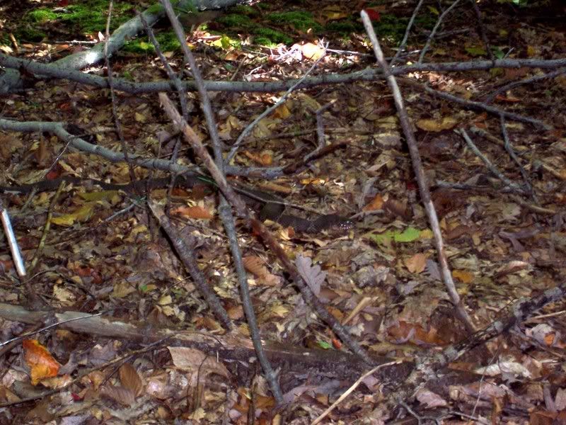
Ironically, near New Jersey's copper mine series. He sat there perfectly still. Glad my friend saw it because I'm colorblind. Without movement I very well could have stepped on him.
-
I can't even imagine what that would do to the surveying industry!
Relax. I've got an old K&E and a chain you can borrow.
-
You should bring an issue of Weird NJ with you and include it in the photo. If you send it to them there's a good chance you may get published.

-
Hey New York Cachers!
Anyone willing to make a friendly wager?
If New York wins the Superbowl I will hide a "NEW YORK GIANTS ROCK" cache right here in the heart of New England, but if New England wins, then a New York cacher needs to hide a "PERFECT PATRIOTS" cache in the NY/NJ area!
Anyone brave enough to take the challenge?
Just wondering........how are you going to put a cache in the heart of New England when you can no longer place WEBCAM CACHES?? Hmmm??
GO GIANTS!!!
-
I am really new at this and went to put in a waypoint. I entered in the UTM info of the northie and eastie but when I GOTO, it shows it is 6000 plus KMs away from where the actual cache is. Can someone help me in entering the right data. I am using a Lowrance IFinder Expedtion C.
I'm not sure where you live, but be careful not to mix up easties with westies.
-
Have you climbed Mt. Tammany yet?? You could climb up and get Rob's Invite Rob's Invite then take the blue trail around the mountain to the AT and grab Don't Let the Bears Get Ya. It's a good hike. I know I slept well afterwards!
-
First to find! First to find!!..........no skirt........THERE'S NO SKIRT!!
-
If I were the Reviewer, I would publish the cache on the grounds that it was moved 6 feet to the RIGHT....not the LEFT. This sick sense of humor explains why I am NOT a Reviewer.
Welcome to the insanity and good luck with your first cache!
-
It's entirely up to you. Typically, one (if any) FTF prize is left in the cache for the first finder. As for routine maintenance I simply watch the logs and see whats going into / out of the container. You can also get a good feel as to how your container is holding up. An occasional maintenance visit helps keep things neat and in order. Welcome!
-
If this one ever gets archived I already have a container ready to be placed in the area. The CO last logged on in May. Maybe he/she has had some correspondence with the Reviewer.....I dunno.
Edited to say I just realized I am slightly OT.
-
If the north arrow is referenced to a deed book and page, the Surveyor held the original magnetic observation as his basis of bearing. It is, after all just a reference. Where I live the declination is:
Declination = 12° 38' W changing by 0° 1' E/year
An angle of 12° 38' over 700' would result in an error of 154'.
What you could do is take a compass reading on your first cleared line and compare it to the survey bearing.
A "perch" is the same as a "pole" or a "rod" - 16.50'
-
Sounds like your doing the best you can with the equipment you have. I'd be careful using a compass. Look at the north arrow on the Surveyors map. Does it call NAD '83? Does it call for a recent magnetic observation?? Reference a deed book and page?? I'm just concerned about declination.
Check this out.
-
In my opinion, a cache at a roadside memorial is in poor taste. Although I understand the memorials are placed by those who grieve the loss of a loved one, and lately it seems to be more of a common act in the grieving process, I observe most people in that situation are not thinking as clearly as normal. In these parts it is commonplace. These memorials are starting to line our local roadways. They are a distraction to other drivers. I believe it was previously posted that they tend to populate in certain dangerous areas. They do, I’ve seen it.
Although accidents can happen anywhere, on the road they more typically happen at bad intersections and blind curves. Sometimes over bridges that freeze before the road surface. Along these roads, the road crews need to mow to keep the safest line of sight. Now they have to carefully mow around the memorial in a dangerous area. Drivers are distracted by the display adding to the danger. Do we need to pose more unnecessary risk by placing a cache there?. IMHO - no. Even if it’s in an area with a safe pull off, away from the dangers of traffic...why would I want to place (or seek) a cache at such a place of misfortune and sorrow?? I have never put a cache on my ignore list to date. Should one of these pop up in my area...it would be the first.
And if you should find my opinion somewhat cold hearted, know this: I perform funeral rituals and grave side services. I’ve seen too many times the sadness and emotion these families share, and I understand why they erect them. It’s just not for me. And to make a cache that is a FAKE memorial?? I won’t even go into how wrong I feel that is.
-
I'll let you know. Soon. Gonna fire off another email to Scottmandude...he wants to go but he's out of town a lot.
-
I've been known to bolt out of work myself to grab a cache.
My work attire is usually business casual, but sometimes suit and tie.
Ever slam your tie in an ammo box?? It's not pretty.
-
I was told you can do a land survey with a gpsr' I have garmin etrex vista cx, there is nothing in manual
about it ,i'm not for sure what a land survey is, but i beleive it has to do with triangulation
The best way to do this is to call a Professional Land Surveyor, ask him for the coordinates of his office, plug them into your garmin and follow the arrow to his place of business. There you can discuss price.
If you just want to FIND your corners you would need their state plane coordinates converted to Lat / Long. And that's only if your survey is recent and in that system. Even then, you are assuming the marker you may find to be correct. Depending on what you're doing, that could be a dangerous and costly assumption.
Even IF you had an expensive professional quality GPS receiver, YOU could not do an land survey. Only a professionally licensed Surveyor can do that.
I'm not trying to be a wise guy here......I've seen people try the very same thing and fail miserably. On the other hand, I did make money resolving the errors

-
I made a container like that out of 2" PVC and dropped a film canister down it. You held your finger over a hole in the bottom while you poured in the water and it worked perfectly. I wanted to use it in a multi called "Water you doing?" I wrote the coordinates on mylar......so everything was waterproof. Had it nice and camo'd up and ready to set out, when I discounted the idea due to the fact that it could be mistaken for a b*mb. Shame.
-
"Burying your PB jar cache in the sand on the beach of the nudist resort is a violation of the guidelines!"
-
i had to ask one guy if he was willing to keep beating on me until he killed me, and whether or not he was prepared to accept the kind of damage i was going to do to him in the meantime. "you'll win the fight", i told him, "but i'm going to hurt you."
he got back in his van and sped off.
That man was Chuck Norris.


Natureboy44 -- Finds #1000 !
in Northeast
Posted
Congrats NB! I remember when I started caching and ran into your evil hides along the Columbia Trail.
You had 666 finds then, I found that quite fitting. Still do. ;-)