


jmundinger
-
Posts
386 -
Joined
-
Last visited
Posts posted by jmundinger
-
-
It might not be as sophisticated as GSAK, but you can use MapSource - the program that came with your GPSr to edit the note. Download the cache to MapSource then open the properties for the waypoint. Edit the comment field in the waypoint properties window and resave the waypoint. Then send it to your GPSr. Be brief, use shorthand and use only the most important information because the size of the note field is limited, i.e. the GPSr might not accept all of the information that you typed into the comment field.
-
-
How do I know what firmware revision my Venture HC is?
Main Menu < Setup < System - from that page, use the menu button and then select "software version" from the drop-down menu.
-
My firmware upgrade to 3.3 is taking for ever, like 24 hours. Just bought the unit a couple of days ago, any ideas on why this is so!
No. But, as an alternative to using webupdater, you could go to the Garmin website and download the software directly and then run the software from your computer.
-
twice now I have downloaded coordinates into my gps, and some how the coordinates got changed slightlly in the process, leading to 2 hours of wild goose chase about a quarter mile from the right area. I'm baffled, any help wold be great!
As others have suggested, my first thought was that your gps was set to a map datum other than wgs84.
Here is something you might try. Download the cache to your computer and rename it - I'd suggest using MapSource, which should have come with your gps. Then, after also sending the cache to your gps, download it from your gps into MapSource. Then, compare the plot and the coordinates for each of the two points (they should be the same).
-
My wife and I recently started geocaching and immediatly loved it. I found a Lowrance ifinder H2O for $60.00 and we got started, the only thing I didn't like was the lcd screen, and if I was to download anything from my computer I would need to spend another $50.00 for the cable. So I found a refurbished Etrex Cx for $120.00 with all the cables. But I find the Lowrance to be more accurate, and I mean alot, like 50-90 feet.
I keep hoping something is not setup correctly. With the Lowrance we use the compass for findingthe cache, and the compas on the Etrex is not even close sometimes. I thought maybe someone with more GPS experience might be able to help, so here I am.
Why would you purchase a refurbished, discontinued model when, for the same price, you could have purchased a new Venture HC?

-
I have had a Venture HC for a few months now and I am getting the hang of it. The only thing I would like to do that would make it so much easier is to be able to find the nearest cache rather than spelling out the cache code. I know you can do this after you find one, but it doesn't always pull the one I want to go for next if there are more than a couple in an area.
I normally do it by going to the map and pointing to the cache on the map, but sometimes that is a little tricky and it involves scrolling through bunch of screens.
I just got the basic eTrex H for our Cub Scout pack and it has this feature and it is great! Right from the find waypoint screen you can scroll down to the nearest caches then search from the nearest 4-5. Why can't a more expensive model do the same thing?
Menu > Find > Geocaches and, when you get to that page, press the "menu" button and select "find nearest"
-
I have a garmin venture hc. Im having trouble figureing this thing out. What do i have to do to enter in an address? Where do i find apps to add to the device? Is Garmin the only place to get maps? I found where to buy maps but the are 100 bucks that seems like alot for the device
Here is a place to get maps
And, download the manual for the Legend C - it has the same functions as your gps and the manual for it was more complete.
-
I have a friends Magellan Meridian Gold. I enter a way point manualy, entering the exact Lat Lon of a cache as listed. After i save, it records and plots a different set of Lat Lon then I entered! I hit edit and it reverts back to what i entered. This means i need to figure out the diference and enter the wrong Lat/Lon to get the right one appearing.
Also, the amount it was off by on one side of Australia (Perth -.071Lat and +.092Lon consistantly ) differs from the other (Melbourne -.019 and -.012)
Is there a setting i have wrong or what's hapening???
HELP!
Scott
The gps is probably set to a different map datum than that used by the source for the cache coordinates.
-
I have the garmin etrex legend H gps (it's the blue one), and I bought it used with no cords...trying to find one. Someone said it's the 2.0 mini usb and I found them online, we even HAVE them, but there's no place to put it, that I can find. The only place I can find to put anything is at the top, and it's a flat square with 4 metal dots...anyone know what kind of cord I need???

If that unit requires a serial cable, I think you have an eTrex H (or, the original legend), not a eTrex legend H. The legend H uses a usb cable.
-
lee, I was holding it with my right hand, in no particular way (back of the device to the palm of my hand, so that I could take a peek at the map once in a while).
jmundinger, can you provide me any link for that product, so that I can find a place where it is sold?
-
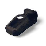
By the way, is there any accessory (Garmin or any other brand) that enables one to carry the GPS unit on the arm or wrist?
Made specifically for the eTrex series:
-
Thank you all for your replies.
I had this feeling that my unit was slower after the upgrade and I was just wondering if that's just me or if in fact there is a speed diference.
I still didn't downgrade it, but now I know it is possible.
By the way, the unit's software isn't the only thing that can be upgraded. I remember there was also an upgrade being done to the GPS chipset.
Can/should this also be downgraded? And how can I tell the type (B/G/M)?
I was one who advocated for the software 2.80/chipset 2.50 configuration with the Vista HCx. After a couple of the updates, I reverted to that configuration because I didn't like the way the newer versions worked - primarily issues related to multi-path and corresponding inaccuracies in track logs. However, I am now using 3.20/2.90 - which I think is the most current version and am very satisfied with it.
You can revert to the earlier versions but, when you do, it reverts the unit to the factory default settings, except for the welcome page, and erases all the waypoints, tracks, etc., i.e. everything on the internal memory. Download all of the data that you want to keep to your computer so that you can upload it back to the gpsr. Connect the gpsr to the computer and double-click the program for the firmware version you want to use. To downgrade the chipset, you have to have both the rgn file and the updater - preferably both in the same folder. To run it, drag the updater over the rgn file and webupdater will launch and revert the chipset.
-
Alternatively, to could you could use UTM coordinates and calculate the distance using the Pythagorean Theorem.
You got my interest. However, I suspect that UTM has even more issues than OSGB with respect to zone boundaries. I suspect that the same zone letter means the same latitude wherever you are in the World, but how do you deal with a change in numerical portion? For example, how do you calculate the distance between 30U 0632481, 5680051 and 31U 0385893, 5757484?
Also how do you deal with the problem of the overlap that arises from projecting the curved ground to a flat mapping? For example, you could have two sets of coordinates, with one from 30U being further east than one in 31U even though zone 31 is east of zone 30! It all seems instinctively very messy to me!
Geoff
Geoff - the solution that I suggested would work within a zone but probably would not work if the waypoints in question were in different zones.
-
I'm trying to create my own distance calculator, but I don't know the formulae for calculating the distance between two sets of coordinates. IIRC, the distance that corresponds to a degree of longitude depends upon the latitude with this being greatest at the equator. I suspect that (because the Earth is flattened at the poles) that distance per degree of latitude also depends on the latitude. So it's not the simple Pythagorean calculation that would apply to a plane - i.e. distance = sqrt((x2-x1)^2 + (y2-y1)^2)
Help!?!
TIA,
Geoff
The distance between two waypoints is calculated using the great circle formula.
1. Distance = acos(sin(lat1)*sin(lat2)+cos(lat1)*cos(lat2)*cos(lon1-lon2))
where all lat and longs are expressed in radians
2. Angle between two waypoints = mod(atan2(sin(lon1-lon2)*cos(lat2),cos(lat1)*sin(lat2)-sin(lat1)*cos(lat2)*cos(lon1-lon2)), 2*pi)
where all lat and longs are expressed in radians
3. A Nautical Mile is 1/60th of a degree or one minute of latitude. Converted to feet by multipling by 6076.11549
or at least that's what google says

Alternatively, to could you could use UTM coordinates and calculate the distance using the Pythagorean Theorem.
-
Grasscatcher, I understand your point about 1 meter, so I'll concede. However, I'm a mechanical engineering major and DMS is incredibly simple to me. (I just didn't know the UTM format, nor how to use it). 1 degree of latitude at the equator is 60 nautical miles, so one minute of latitude at the equator is 1 nautical mile.
A mechanical engineer ought to be able to think metric.

The UTM system uses 1 km grid squares and, as previously noted, the coordinates define a square meter. And, while we are on the subject, note that you have the option of setting your gps to display direction in mils rather than degrees. There are 6,400 mils in a circle. And, an angle of 1 mil defines an arc of 1 meter at a thousand meters.
-
If I just keep staring stupidly at the manual that came with it, the result will be the same.
Barb - actually reading the manual, preferably for comprehension, would be a significant improvement over simply staring at it.

Second, note that the manual that comes with the newer units is a little skimpy - but it still should be enough to get you started. The manual for the Legend C, a discontinued unit, is a lot more comprehensive. That older unit has the same functions as the unit that you bought. You can download a pdf file of that manual at:
https://buy.garmin.com/shop/store/manual.js...167&pID=255
Here are a few thoughts that might help you get started:
1. You have to press and hold the power button to turn the unit off/on. It takes a little while for the unit to actually turn on and then a bit longer for it to find the satellites. The first time you use it, it might take a half an hour to get a good lock on the satellites - turn it on and place it level in a spot where it the unit has an unobstructed view of the sky and leave it for a few minutes.
2. Familiarize yourself with the buttons - that is the basic way you have to communicate with the unit. The functions of these are briefly described in the manual. As you look at the unit, there are two buttons on the right side - the lower one is the power button(off/on or, if held briefly, turns on the backlight), the upper is the "page" button. (more on that one in a minute). On the left hand side of the unit, there are three buttons - the top two zoom in and out, used for changing scale on the map page. The lowest button is the menu key or, if held, will select the find page. On the face of the unit is a joystick - it functions like a mouse to move up/down, right/left and enter to perform various functions on the pages.
3. Familiarize yourself with the pages - there are several. The pages are all of the functions. Use the page button to scroll through the "main" pages. (you can add/remove pages and change the sequence of pages on the list of main pages - don't do that until you get familiar with the unit and have a sense how you want to use it and, if you do edit that list DO NOT remove the Menu page from the list). One of the main pages is the menu page. That page displays all of the pages that are not on the list of main pages. Navigate through that page with the joystick and select each page. Within each page, again use the joy stick to access the features and functions available on that page and press the menu button to access additional functions on that page.
4. It's just a piece of electronic equipment. Don't be intimidated by it
-
Brains (at least mine) don't work in D M S when trying to visualize distances......what distance you read is what distance you get with UTM......down to 1 number difference?? then you are within 3 ft. Kinda one of those DUH moments.....
UTM is also a lot easier to describe your location on a topo map than PLS.
-
What I don't understand is how they came up with UTMs in the first place; what GPS reads in UTM?
I have a couple of Garmins in the eTrex series and both of mine can be set to display utm coordinates.
-
Explain, please.
I entered the UTMs that I posted (as WGS84) in the link that I posted and got a set of Lat/Lons, in D-M-S that fall about 8 feet off of one of the roads through Greenmount Cem when viewed from Google Earth. What makes you concerned?
When I plug Z13 245590E, 4131613N, into your converter I get 37 17 46.6 lat, 107 52 12.596 lon.
Is that what you get?
Be sure that I've got the correct UTM numbers above.
That's what I got, assuming WGS84 datum
Degree, Minute, Second:
Latitude: 37° 17' 46.693" N
Longitude: 107° 52' 12.596" W
or,
Minute, Decimal:
Latitude: 37°17.77822279541
Longitude: -107°52.209932700309
That plots out in the middle of the river, west of the Riverview School.
If NAD27 data is assumed, I get a point about 600 ft to the north of that point, on the other side of the river.
-
I was given coordinates to a grave that I'd like to catalog near Durango, Colorado. The coordinates I received are:
13245590E
4131613N
just as typed. I have no idea if this is decimal degrees, degrees and decimal minutes, or D-M-S, so I thought I'd just enter them all to find out what puts me where I expect it should be; not too hard, huh?
The cemetery is basically,
37º 16' N
107º 53' W
I first assumed that the E and W were just a typo, so I went from there, and everything fell apart. Is there a coordinate system that uses a number like the first one that would be close to the cemetery as I show it above?
I agree. Those are UTM coordinates. And, if I had to guess, the datum is NAD 27.
I plotted the coordinates using USA Photomaps and the coordinates correspond to approximately 37 17.286 N 107 52.214. I'm pretty sure that USA Photomaps uses WGS 84, so those coordinates won't work for you. Besides, in USA Photomaps, the coordinates are in the middle of the Animas River. It got to Durango, but probably not to the cemetery that you are looking for.
-
Just about any handheld (non-auto) GPS will do this, but entering coordinates by hand is fraught with opportunity for error. I strongly suggest a unit with a USB cable. The eTrex Venture HC, the next model up from the eTrex H, has it.
I second this suggestion, and the difference in cost is about what you would have to pay to get the serial cable and usb adapter. For that additional cost, you also get MapSource and a base map (very simple), more functions and a unit that is a little easier to use.
-
I just bought a Garmin 265T and we tried some caches today. It seemed to bring us to a parking spot just off the road but not to a place within metres of the cache like it seemed when I went with a friend some time ago. Needless to say, parking a car and then looking around reveals a grand scale of possibilities. Am I doing something wrong, or is this 265 for vehicle usage and not for geocaching?
Any ideas or recommendations are welcome. Thanks.
It would be easier to cache with a gps unit that has a compass page (i.e. a unit designed for trail use) rather than a unit intended for use in a vehicle. However, I suspect that you can cache with that unit but you will have to change the settings from vehicle use to pedestrian use, assuming that unit has those options.
-
We bought a eTrax Legend HCx it holds 1000 waypoints and I am slowly entering them one at a time. My question is how do I drop a bunch at a time into the unit. Honestly the area I am trying to get in is Edmonton (as the kids have almost cleared our area of Leduc) and doing it one at a time seems redundant as I am positive that I am redoing half of the ones that are already in there every time I sit to do adds. I tried to check to boxes on the right and download all waypoints from one page but once I do that and it saves to my computer there is nothing to open that file? Please anyone who can give me dummy directions that wold be awesome!
That unit comes with MapSource. It is a very basic map but it does include the capability of transferring data back and forth between your computer and the gps. You could also use a piece of free software to do the job - EasyGPS. Build the waypoint file in one of those programs and then transfer the data to your gps.
If you are talking about waypoints for caches, you can download them directly to the gps or download them into either MapSource or EasyGPS and, if you wish, edit the note that will appear on the gps by editing the waypoint properties.
Many folks here use GSAK to manage their waypoint files. Someone will probably post with information about how to use that.


the gpsstore.com
in GPS technology and devices
Posted
The 60CX and 60 CSX are NOT the same units. The 60CX is a discontinued model and uses an older and less sensitive receiver.