

Butano
-
Posts
161 -
Joined
-
Last visited
Posts posted by Butano
-
-
There is an "X" near the BM lettering. The X marks the actual position of the benchmark. But I have found that sometimes that is not completely accurate. Look at the datasheet for the benchmark for the accuracy and the go to description. I have found sometimes the coordinates listed are more accurate than the marks on the map, and sometimes the mark is more accurate.
-
I was thinking something like a dog collar, but am not aware of any that might have an API that you could access (I didn't look either). Sorry for not doing the legwork (but then maybe I could work at your company
 , but take a look at this sight http://www.programmableweb.com/news/51-gps-apis-breadcrumbs-ipoki-and-waze/2013/10/16 and see if there is something that jumps out at you. Lots of different APIs, might give you a hint for GPS that you could use. Maybe even use a smartphone and accessing an app on there. Just a couple of ideas.
 -
OK, I see the problem. The coordinates you are entering are N 41 63.691. That means North, 41 degrees, 63.691 minutes. Since there are 60 minutes in a degree, it is normalizing it, adding one to the degrees to make it 42 degrees, and then subtracting 60 from the minutes to make it 3.691. What is displayed does match what you entered (same location). But that 63.691 value looks suspicious to me. Make sure that is what you really wanted, and if it is, then the web site is working as designed.
-
What coordinates are you trying to use? Make sure that you use a minus sign or a W for the longitude, otherwise you will be on the wrong side of the earth. Also make sure that the coordinates are in the right format. Typically you will want to use degrees and minutes (xx xx.xxx).
-
The first file, 34525324347_Montpelier.gpx, contains the actual cache description and location, and is probably the one that you want. The second file contains the additional waypoints associated with the caches. These additional waypoints may be parking locations, stages of a multi-cache, or whatever the cache owner has decided to add to the cache page. For instance, this Earth Cache is located at N 38° 35.763 W 122° 34.229. That location and the description would be located in the first file. Also associated with the cache is a parking location (just above the logs on the cache page). That location would be located in the second file.
Hope that helps.

-
That is very cool.
 I have an Arduino. I have been using it to control my Christmas lights, but thinking about some application for Geocaching too. Images of Dr. Who come to mind. But this sounds like a good idea. Like the Morse code portion of the it too. I would be interested in seeing something.
 -
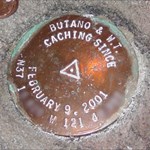
But where's the benchmark? Cool witness "post" though.
-
I agree with team tisri. It is probably a rounding error. I would suspect that it has been happening all along and you didn't notice it. Sometimes it would happen, other times not. I would give some of the ones that you know were correct in the past and try it again just to see. If you enter a "new" value in, does that change now?
-
If you are looking for a generic XML editor (GPX is a type of XML file), give XML Notepad a shot. I use it quite a bit when editing XML files, though not often for GPX in particular. Here is a link to the file on Microsoft. http://www.microsoft.com/en-us/download/details.aspx?id=7973
-
Based on your last statement this may not be the case, but when you are on the page that says no matches found, go to options, and then Spell. Make sure that you don't have anything typed in there. I have been caught by that one. Doesn't seem to start over when you think it should.
-
I will give it a try!
-
Sure I will give the contest a shot. I spend time both in Colorado and California, so maybe that will give me a little advantage?
-
The datum does matter. When I first started geocaching I was using a map with a different datum. That put the cache on the wrong side of a slough. Took me about 3 tries before I figured out my problem. There should be a choice for WGS84 on your GPS. That is the system used for GC.com. If you truly don't have a WGS84, you could use NAD27, but don't expect to get too close. I am not sure how close WGS72 is to WGS84, but it may be closer.
The three letter at the name of the datum indicate a name of the datum, the last two digits indicate the year that it applies to. NAD is North American Datum, WGS is World Geodetic System. There are many others. The last two digits indicate the year that the data was measure, or put into use. 1927, 1984, etc. There is a WGS96 system out there, but it doesn't seem to have caught on.
Good Luck!
-
If you use GSAK there is a macro that will generate a epub format. The macro is listed here. I think that will do what you need. There is other software that is needed as well, so read the whole forum. I haven't used this macro, but have used the one for the Kindle. It is kind of nice.
-
I don't consider any of the above solutions as actually paperless. True paperless means you can hook it up to your computer and upload the field notes file to GC (or GASK). These methods allow you to read the info on a device in the field.
Er, no, actually paperless means that you do not use paper, irrespective of how you get your logs to GC so long as you do not use paper.
Thats true but the Kindle doesn't not allow you to log the cache so is is not paperless.
I haven't actually tried it, but there is the experimental browser on the Kindle, so theoretically you could log your finds using that. A very separate step from looking at the information through the eBook format. The little bit I have played with the browser, it looked pretty basic. You might need to use the WAP version of GC.com to be successful. My Kindle is WiFi only, so I wouldn't be able to use it out in the field until I hit a McDonald's.

-
Actually it isn't too difficult. If you are using GSAK, then there is a macro for generating mobipocket formatted file. That can be found here in the GSAK forums. You will also need to download the mobigen executable described in the thread. After running the macro you will end up with a file, You can then e-mail the file your Kindle (something like MyKindle@kindle.com). Then the next time that you synch the Kindle, it will show up.
-
Sounds like you may have figured out a solution. But the main problem that you are having is that the .loc file format does not include the scription or other information, just the basic location information.
-
The computer has detected (or thought it detected) an error on the USB port. What you can do there is to right click on the item that has the yellow exclamation mark and click uninstall. This will remove that port from the list. Then go to the Action menu item and click Scan for hardware changes. This should pick up the port that you just uninstalled and reinstall the drivers for it. Hopefully that will take care of the problem. Good luck!
-
You might try doing a master reset as well. I believe that you hold down both soft buttons (just above the screen) while powering the unit on. The Colorado Wiki that was mentioned previously would have the correct instructions if that isn't it. http://garmincolorado.wikispaces.com/
-
If you look at the pocket query build page, the fourth section down is labeled "That (and)". There is an option for "Is not active". You can select that and it will give you the disabled and archived caches. But beware, you can't select that option and the "Is active" option together since a cache cannot be both not active and active. So you will need to create a separate query for that. I have one that I run that includes "is not active" and "Updated in the last 7 days" so I get the most recent updates and not a whole bunch of archived caches from 2000. Then I have that set up to run twice a week, just to be sure that I get everything that gets archived. You may want to run it without the last 7 days initially to get your database initialized. Pump that into GSAK and you will be ready to go!
-
Not sure if you found web page or not, but there is a ton of information there about the Colorados. http://garmincolorado.wikispaces.com/.
My answer to the first one was going to be to calibrate your compass. Guess you did that. I often turn my compass off and rely on my movements to get the direction. Since the compass has to be recalibrated so often, it is just easier (shouldn't be that way, but there it is).
It sounds like you have figured out how to put caches on the Colorado - by uploading a GPX file to it. The only way to delete a cache is to delete (or modify) that file. You will need to connect it to a computer to do that. Unfortunately there is no on-the-fly way to delete the cache.
My screen does not turn black, but there is an image of the GPSr hooked to a computer when I do that. Couldn't guess why yours would not show that. But it seems to still be working. And yes, it is normal for the GPSr to shut off when it is disconnected from the computer, at least mine does that as well. The way that it recognizes a new geocache file is during the bootup process. So it needs to go through that when a new file is loaded.
Hope that helps!
-
The only way to delete a cache is to remove the file that contains the cache. This is done when you have the GPS hooked up to your computer. So out in the field, you can't do that. But you can mark one as found and then it won't show up in your list of unfound caches (the default listing).
See this Colorado GPS wiki page for a lot of good information about the Colorado, more than just the Geocaching page that I am point at here.
I like my Colorado, though there are a lot of people who complain about it. A couple of problems, but overall it has been a lot of fun to use.
-
I got a request too. Really emphasized that I wanted a bit more benchmarking support as well.
-
This code looks so similar to the GPX format that pocket queries use that I wonder why Nokia just didn't use that format.
Take a look at GPSBabel. It allows you to convert between various formats. Included in the conversion capabilities is the LMX format (looks like it is called Nokia Landmark Exchange). With this program you will be able to import a pocket query and convert to the LMX format. That should help you convert even faster.
I have not tried this particular conversion, but the other conversions are very stable and are used extensively in other software like GSAK and Google Earth.
Good Luck!
 , but take a look at this sight
  I have an Arduino. I have been using it to control my Christmas lights, but thinking about some application for Geocaching too. Images of Dr. Who come to mind. But this sounds like a good idea. Like the Morse code portion of the it too. I would be interested in seeing something.
Anyone Going to Maui?
in West and Southwest
Posted
Hi McIrish. We will be in Maui in June, and found some caching. Which cache are you wanting someone to take a look at?
Butano